|
Various Contributors
The Illustrated London News, 22 July 1944
Cover: The First Entry of Canadians into Caen. Features include: Our Notebook; Book Review: "The Bank of England: 1694 - 1944" by Reginald Saw; The Great World War: Moving on in Italy (inc maps); Books of the Day; and The World of Science: Wood Comes of Age. Pictorial Journals include: In Liberated Caen: The Mayor Hoisting the Tricolour; Caen After the Battle: The Key City of Lower Normandy, whose Capture Marked a Valorous British Victory; Two Aerial Photos: German Atlantic Wall, Eastern Section of the Cherbourg Peninsula; On the Western Front (Battle of Normandy): War and Its Aftermath; On the Western Front: Scenes From the Battle Zones of British and American Armies in Normandy; The Red Army Surges On: Important Cities in the Path of Battle; A Lancashire Fusilier's V.C.: Fusilier (Francis Arthur) Jefferson, Single-Handed, Breaking Up an Enemy Tank Attack (illustrated by Captain Bryan de Grineau); The Onward Advance of Gen. Alexander's Armies: War Scenes at Castiglione, Lake Trasimeno, The French Entry into Siena; Mediaeval San Gimignano and Its Towers; The War in Burma: The Clearing of the Kohima-Imphal Road; The Japanese Main Fleet Caught Napping - Another U.S. Sea Victory (Battle of Philippine Sea); New Additions to our Fighting Power: Flying Bombs from Start to Finish; A Threatened View - Durham Cathedral from River and Railway (illustrated by Sir Muirhead Bone); and War's Trail of Devastation in Normandy: Historic Buildings Wrecked in Fierce Armoured Battles on the Allied Front. Binding sound. Clean and unmarked with minimal wear. A quality copy. Book

|
|
|
Various Contributors
The Illustrated London News, 23 September 1944: The Invasion of Holland
Cover: Le Touquet, France Canadian Soldiers Walking Along Promenade. Features include: Our Notebook; Book Review: "Norfolk Portraits" by R.W. Ketton-Cremer; The Great World War: Is This the Final Round? (inc maps); Books of the Day; and The World of Science: The Problem of Migrating Birds. Pictorial Journals include: Stubborn Resistance - American Troops in Moving Up for the Final Assault; The Greatest of Airborne Operations - The Invasion of Holland; Canals and Rivers of the Netherlands, Scene of a Vital Battle (inc map); Le Havre: The British Capture of the Important Enemy-Held Port; Infantry and Flame-Throwers in Action: Some of the Prisoners; The Triumphant Advance of the Allies: Scenes of Liberated France and Belgium; The Dutch Landscape Covered with Grounded and Falling Allied Parachutes; The First Penetration By U.S. Troops of the Siegfried Line; The A.V.R.E.: A British Mortar Tank Designed for Breaching Fortifications; The Battle of Britain Commemoration Service in Westminster Abbey on Sunday, September17, 1944; Secrets of the Flying Bomb: Constructional Details Revealed; The Mystery Structure Near St. Omer - Believed a Long-Range V-2 Base; The Quebec Conference, 1944; War Items of Interest; Pencil Studies of Gandhi and Jinnah, Who Recently Met in Bombay (illus. by Feliks Topolski); and Norman Wilkinson's Exhibition of "War at Sea" Paintings in London. Advertising cover: moderate to excessive wear, with prior owners ink stamp with some writing centre front cover. Page 339/340 missing. Page 361/362 loose but present. Covers loose and taped at fold. Contents clean and unmarked. A worthy reading copy. Book

|
|
|
Various Contributors
The Illustrated London News, 3 March 1945
Cover: A Triumph of Road-making: The First Allied Convoy to China to Break the Japanese Blockade. Features include: Our Notebook; Book Review: "Persons and Places" by George Santayana; The Great World War: The American Passage of the Roer (inc maps); Books of the Day; and The World of Science: The Locust's Year of Decision. Pictorial Journals include: The Rocket That Would Not Go Up! - Photos of an ill-fated rocked experiement by Herr Johannes Winkler in 1932; U-Boat Warfare - 1939 - 1945: A Survey of Changing German Submarines and Tactics in a Never-Ceasing Battle (Illus. by G.H. Davis); War Scraps: Incidents at the Front and Behind the Lines; On the Western Front: The American Advance into Germany; Battle Incidents with the Third and Seventh U.S. Armies; The Battle for Goch: British Troops in the Wrecked German Fortress Town; General Crerar's Offensive: The Storming of Cleve (Illus. by Capt. Bryan de Grineau); General Crerar's Offensive: British Troops in Mortal Combat With the Germans in the Reichswald (Illus. by Capt. Bryan de Grineau); The Zeitz Synthetic Oil Plant: Before the R.A.F. Attack - And After; War in the Pacific: Luzon Island and Iwo Jima; With the Red Army: Scenes From Liberated Poznan; Bombed Bath: Proposals for Replanning; and Masterpieces of Painting From the Cook Collection. 8" opening to page 241/242. Remaining contents clean and unmarked with minimal wear. A worthy copy. Book

|
|
|
Various Contributors
The Illustrated London News, Saturday, June 17, 1939 - Cover Photos of the King and Queen with President And Mrs. Roosevelt
36 pages. Features: Photos of the memorial services for the "Thetis" victims; Photos of Axis Activities - "Volunteers" return from Spain - Italy's Navy Day - Kondor Legion goose-steps past Hitler; Maps of the strenuous Royal Tour; Cross-section illustration and photos of their Majesties' "Royal Yacht" for their return to England in the "Empress of Britain"; Great photos of unusulally-placed bird nests; Amazing illustrations of the feet of various Australian animals; Colour photos of pageantry at the Aldershot Tattoo; Photos of the Royal Tour through the Rockies from Banff to the Pacific; Five photos of the Royals in British Columbia; Photos of the Royals returning eastward across Canada to Niagara; The King and Queen in Washington - photos; The Royals in New York City; Classy two-color ad for Wills's Gold Flake cigarettes; and more. Average wear. Unmarked. First three pages loose but present. Pages 1127-28 and 1131-32 and any pages after 1134 are not included. Despite its deficiencies, still a worthy copy. Magazine

|
|
|
VATICAN MAPS.
The Gallery of Maps in the Vatican.
Modena: Franco Cosimo Panini 1994. 3 volumes quarto. Original black cloth spines lettered in gilt. Housed in the original black cloth slipcase. Volume one text; volume two with colour reproductions of maps and various other artworks; volume three with 40 folded maps. Other than the most minor of scuffing a fine copy. A handsome comprehensive publication of the maps and associated items housed in the Vatican collections. With parallel Italian and English text. Modena: Franco Cosimo Panini, hardcover
Bookseller reference : 137737

|
|
|
VAUTRE Le Général Bon de
Genie du Whist méconnu jusqu'à present, quoique joué avec une espèce de fureur par toute l'Europe, avec ses explications et des maximes certaines pour gagner. Deuxième édition
Paris Ledoyen s.d. [1839] in-18 br., couv. impr
Bookseller reference : 11981
|
|
|
VAUTHEY, P, Docteur (Pour la notice médicale) -Cartes & Plans de E. FONNE
Guide pratique de VICHY et environs - La Saison, La cure, Les Eaux, Notice médicale, Les Fêtes, Promenades, Excursions
LYON, guides Pol - In-16 - 7 Edition, vers 1914 - Brochée - 7 plans, 4 cartes dont 1 HT dépliante, 2 profils de route, Gravures en texte - 92 pages + environ 60 pages de publicités régionales, certaines illustrées - Propre
Bookseller reference : 13093
|
|
|
VAUCLUSE.
Nouvelle carte départementale. Vaucluse.
1910 carte en coul., rempl. de 60X80 cms, couverture imprimée. Paris André Lesot (ca.1910),
Bookseller reference : 6936
|
|
|
VAUGONDY, ROBERT de - RUSSIA.
Partie Occidentale de L'Empire de Russie, ou se trouve distinguée La Russie Européenne...(Paris), 1750.
A large engraved cont. handcoloured map of the Northern part of Russia from Novaja Semlja in the north to the Caspian Meer in the South, from Finland to Jakusskkáy, measuring 48,5 x 62 cm. Folded in center. A few tears in margins.
Bookseller reference : 16523
|
|
|
VAUBAN par Adrien MELLION.
Vauban, l'homme de guerre, l'homme d'état, l'homme privé. Portrait gravé, cartes.
Paris, Librairie Générale des Publications Populaires 1886. Bel exemplaire relié, rel. demi toile avec coins, gd in-8, 143 pages.
Bookseller reference : AUB-3781
|
|
|
Vaugondy, Robert de
Karte von Rußland: Partie Occidentale de l´Empire de Russie, ou se trouve distinguee la Russie Europeenne.
O. O. [um 1750]. Grenzkolorierte Kupferstich-Karte mit Kartusche links oben. Blattgröße: 49,5 x 65,5 cm. Am Kopf bis in den Plattenrand beschnitten und etwas wasserrandig. An den Rändern stellenweise etwas bestoßen und mittig am Fuß mit kleinem Darstellungsverlust.
Bookseller reference : 35070

|
|
|
VAUGONDY, ROBERT de - RUSSIA.
Partie Occidentale de L'Empire de Russie, ou se trouve distinguée La Russie Européenne...(Paris), 1750.
A large engraved cont. handcoloured map of the Northern part of Russia from Novaja Semlja in the north to the Caspian Meer in the South, from Finland to Jakusskkáy, measuring 48,5 x 62 cm. Folded in center. A few tears in margins.
|
|
|
Vaugondy, Robert de.
Antiquor[um] Imperiorum Tabula [...]. [Paris], Robert de Vaugondy, 1757.
Engraved map (73 x 52 cm), hand-coloured in outline. This finely engraved map, published in Vaugondy’s “Atlas Universel”, extends to the Caspian Sea in the north, in the west to show Greece, east to the Indus River, and south to include the Red Sea and the Nile River valley. Almost the whole of Arabia is blank and unexplored, but parts of Oman and the cities and places along the Arabian Gulf are indicated. In good condition. National Maritime Museum Cat. I, 317. Al Ankary 185.
|
|
|
VAYRON (François Benjamin).
Les étrangers à Paris. Visite avec itinéraire à ses principaux monuments.
Paris, G. Gautier, 1855. En 4 feuilles montées sur carton fort doublé de percaline moirée et repliées, de 495 x 630 mm.
Bookseller reference : LBW-5731

|
|
|
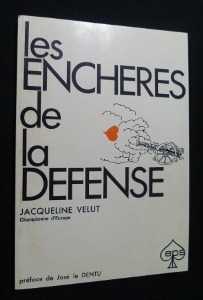
Velut Jacqueline
Les Enchères de la Défense
Les Editions de la presse spécialisée Broché 1971 In-8, (18x12.5 cm), broché, 90 pages, préface de José le Dentu ; plats légèrement défraîchis, bon état. Livraison a domicile (La Poste) ou en Mondial Relay sur simple demande.
Bookseller reference : nf185
|
|
|
VELICKOVIC (Vladimir).
Menu illustré d'une gravure originale signée.
Paris Société Les Amis du livre contemporain 2003 1 vol. Broché Menu dépliant sur Arches illustré d'une lithographie (35 x 25 cm) signée par Vladimir Velickovic. En parfait état.
Bookseller reference : 109143
|
|
|
VELICKOVIC (Vladimir).
Menu illustré d'une gravure originale signée.
Paris Société Les Amis du livre contemporain 2003 1 vol. Broché Menu dépliant sur Arches illustré d'une lithographie (35 x 25 cm) signée par Vladimir Velickovic. En parfait état.
Bookseller reference : 109143
|
|
|
VENO, Robert
La prestidigitation facile avec le cours Magica. Cours complet en 12 leçons
Couverture souple A, Mayette 1954 Paris 24x16 cm
Bookseller reference : 1868
|
|
|
VENDEE
Nouvelle carte d?partementale. Sans date.
1 feuille repli?e 80x60 cm.
|
|
|
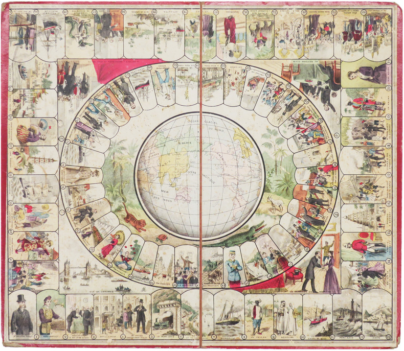
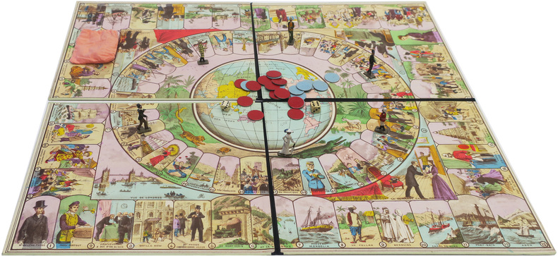
VERNE (Jules).
[Le Tour du monde en quatre-vingts jours d'après Jules Verne].
[Paris, Les Jeux et Jouets Français, vers 1915]. 485 x 559 mm ; en deux sections montée sur carton, et pouvant être repliées.
Bookseller reference : LBW-8568
|
|
|
VERRUA. MANUSCRIT.
[Plan de la forteresse de Verrua sur le Pô, près de Crescentino].
1705. En quatre feuilles jointes de 1,14 x 0,81 m.
Bookseller reference : LBW-4126

|
|
|
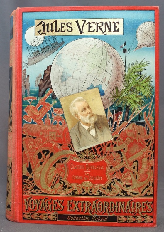
VERNE Jules:
Claudius Bombarnac - Le château des Carpathes.
Paris, Bibliothèque d'éducation et de récréation - Les Voyages extraordinaires, J. Hetzel et Cie, [1892]. Grand in-8 de [8]-285-[7]-199-[2]-8 (catalogue) pages, cartonnage polychrome d'éditeur "au portrait collé", dos au phare, tranches dorées. Dos passé, rares et pâles rousseurs, coins inférieurs à peine frottés, gouttière impeccable.
Bookseller reference : 10955
|
|
|
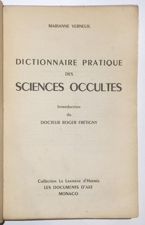
Verneuil, Marianne :
Dictionnaire pratique des Sciences Occultes. Introduction du Dr Roger Frétigny.
Monaco, Les Documents d’Art, 1950, gr. in-8, br., 489 pp., nombreuses figures.
Bookseller reference : 821
|
|
|
VERNE, Jules - Dessins de P. Philippoteaux - Fac-similé et cartes par Matthis et Morieu
Histoire générale des grands voyages et des grands voyageurs. Les grands navigateurs du XVIIIe siècle.
2010 Editions Atlas - 2010 - In-4, cartonnage illustré en couleurs et en doré de l'éditeur; tranches dorées - 410 p. - Nombreuses illustrations in et hors texte en N&B + 66 fac-similés et cartes
Bookseller reference : 119018

|
|
|
VERNE (Jules).
Le Tour du monde en quatre-vingts jours, d'après Jules Verne.
[Paris], Les Jeux et Jouets Français, [vers 1915]. Boîte de jeu cartonnée de 25,2 x 33,6 x 4,2 cm ; grande lithographie illustrée en couleurs sur le couvercle.
Bookseller reference : LBW-8567
|
|
|
VERSINI Georges
LE BRIDGE
1968 broché in-octavo tellière (paperback), dos blanc (white spine), couverture verte (green cover), illustrations : figures et tableaux (pictures and tables), 128 pages, 1968 Paris Presse Universitaires de France,
Bookseller reference : 4459
|
|
|
VERAME Jean.
Les merveilleuses cartes à jouer du XIXè siècle.
Paris, Nathan, 1989. Grand in-4 : cartonnage noir bradel, titre en rouge en long, bien complet de sa jaquette illustrée, gardes illustrées (cartes en couleurs).
Bookseller reference : 20231
|
|
|
VERNET (Patrick).
Menu illustré d'une gravure originale signée.
Paris Les Impénitents 1981 2 vol. Broché Menu imprimé sur Arches et illustré d'une eau-forte en couleurs (6 x 10 cm) signée par Patrick Vernet. En parfait état.
Bookseller reference : 109106
|
|
|
VERNET (Patrick).
Menu illustré d'une gravure originale signée.
Paris Les Impénitents 1981 2 vol. Broché Menu imprimé sur Arches et illustré d'une eau-forte en couleurs (6 x 10 cm) signée par Patrick Vernet. En parfait état.
Bookseller reference : 109106
|
|
|
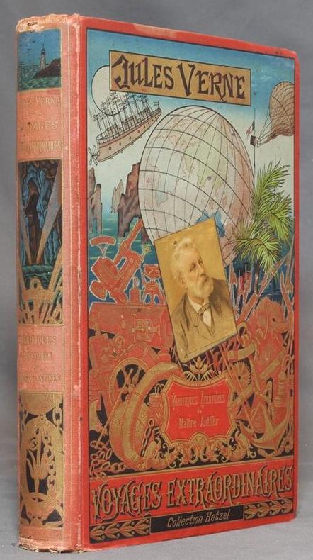
VERNE Jules:
Mirifiques aventures de Maître Antifer.
Paris, Bibliothèque d'éducation et de récréation - Les Voyages extraordinaires, J. Hetzel et Cie, 1894. Grand in-8 de [4]-420-[2]-8 (catalogue HF) pages, cartonnage polychrome d'éditeur "au portrait collé", dos au phare, second plat type Lenègre "e", tranches dorées. Auréole au coin supérieur des 80 dernières pages, mors, coiffes et coins inférieurs frottés, coins supérieurs un peu tapés, rousseurs se limitant aux premiers feuillets. Lenègre relieur.
Bookseller reference : 12400
|
|
|
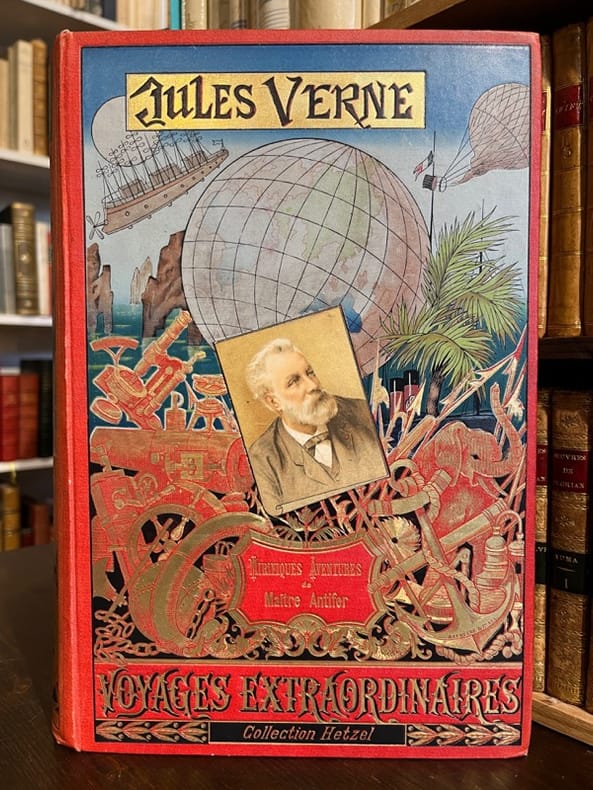
VERNE Jules:
Mirifiques aventures de Maître Antifer.
Paris, Bibliothèque d'éducation et de récréation - Les Voyages extraordinaires, J. Hetzel et Cie, 1894. Grand in-8 de [4]-420-[2]-8 (catalogue HF) pages, cartonnage polychrome d'éditeur "au portrait collé", dos au phare, second plat type Lenègre "e", tranches dorées. Lenègre relieur.
Bookseller reference : 20069
|
|
|
VER ELST, Andre.
Oude Belgische Beroepen in beeld -- Anciens Metiers belges en images.
Zaltbommel, Bibliotheque Europeenne-Europese Bibliotheek, 1978. Hardcover in-8 oblong (21x15cm), 168 pp. entierement illustrees en n&b, cartonnage illustre de l"editeur.- ISBN 9028800638
Bookseller reference : 31676
|
|
|
VERNIQUET - LAGRIVE
Plan de Paris, avec détails historiques de ses agrandissemens et de ses embellissemens, depuis Jules César jusqu'à ce jour
chez Debray A Paris, chez Debray, 1819. In-4 relié cartonnage vert de l'époque de 2, 40, 8, 8, 8, 8 et 8 pages.Ce plan gravé et réduit géométriquement d'après MM Verniquet, Architecte, et Lagrive, Ingénieur, s'étend au-delà des limites nouvellements fixées ; ou sont figurées divers embranchements et bassins des Canaux de l'Ourcq et de l'Yvette tant projetés qu'exécutés, avec leur description ; l'indice de principaux monumens et Etablissemens publics, tant anciens que nouveaux, qui sont établis dans cette vaste cité ; suivi de quelques notes véridiques des Evènemens extraordinaires arrivés dans cette grande ville. Bien complet des 4 plans dépliants en couleurs, ainsi que des 4 tableaux : Du plan de St Denis, lieu destiné depuis plusieurs siècles à la sépulture des Princes français. Du plan ou carte générale du canal de l'Ourcq à Paris, conçu en 1520, où plus de 22 millions ont déjà été employés. D'un plan et description de la Scie mécanique, destinée à récéper les pilotis au fond de l'eau, sans bâtardeaux ni épuisemens dans les travaux hydraulyques, et au moyen de laquelle on économise un tiers dans les dépenses, d'après MM. Perronet, Voclio et Cessart, célèbres ingénieurs de France, méritant d'être connus. D'un plan du premier Pont construit à Paris par ce procédé, avec description. Notes de l'éditeur sur quelques articles des embellissemens de Paris. Précis historique des canaux de l'Ourcq, de Saint Denis et de Saint Maur, à Paris. Analyse des canaux, des rivières de l'Yvette, de la Bièvre, de l'Orge, de la Juine et de l'Essone. Des rousseurs néanmoins bon exemplaire pour cet ouvrage intéressant sur les canaux de PARIS.
Bookseller reference : 99916570

|
|
|
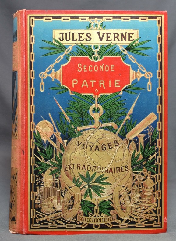
VERNE Jules:
Seconde patrie.
Paris, Bibliothèque d'éducation et de récréation - Les Voyages extraordinaires, J. Hetzel et Cie, [1898]. Grand in-8 de [4]-IV-471-4 (catalogue BH) pages, cartonnage polychrome "au globe doré" de type 3, dos au phare, second plat type Engel "h", tranches dorées. Dos passé, avec petits accrocs en tête et en queue.
Bookseller reference : 11863
|
|
|
Verame, Jean
Sublimes cartes à jouer
Editions du Félin 2007 In-4 relié 33,6 cm sur 26,8. 253 pages. Bon état d’occasion.
Bookseller reference : 135801

|
|
|
VERNE (Jules).
Voyage autour du monde en 80 jours, d'après Jules Verne. Jeu amusant et instructif.
[vers 1915]. Boîte cartonnée de 26,3 x 34,8 x 4,2 cm ; grande lithographie illustrée en couleurs sur le couvercle.
Bookseller reference : LBW-8569

|
|
|
VERDUN DE LA CRENNE Jean-René de; BORDA Jean-Charles, Chevalier de; PINGRE Alexandre Guy, Chancelier:
Voyage fait par ordre du Roi en 1771 et 1772, en diverses parties de l'Europe, de l'Afrique et de l'Amérique; Pour vérifier l'utilité de plusieurs Méthodes & Instrumens, servant à déterminer la Latitude & la Longitude, tant du Vaisseau que des Côtes, Isles & Ecueils qu'on reconnoît: Suivi de Recherches pour rectifier les cartes hydrographiques.
Paris, de l'Imprimerie Royale, 1778. 2 volumes in-4 de [4]-389-[1]-XIX-[3]; [8]-500-XXXII pages, plein veau marbré brun, dos à nerfs ornés de filets et fleurons dorés, pièces de titre en maroquin rouge, tranches mouchetées, petits accrocs aux coiffes supérieures, épidermures, coupes et coins frottés, tampon sur les pages de titre, quelques pâles rousseurs.
Bookseller reference : 8670

|
|
|
VER ELST, Andre.
Oude Belgische Beroepen in beeld -- Anciens Metiers belges en images.
Hardcover in-8 oblong (21x15cm), 168 pp. entierement illustrees en n&b, cartonnage illustre de l"editeur.- ISBN 9028800638 Excellent etat - VG++. [NV-29] Text in French + Flemish
|
|
|
VERAME Jean.
Les merveilleuses cartes à jouer du XIXè siècle.
Paris, Nathan, 1989. Grand in-4 : cartonnage noir bradel, titre en rouge en long, bien complet de sa jaquette illustrée, gardes illustrées (cartes en couleurs). Bel exemplaire. Recherches historiques sur les jeux de cartes.
|
|
|
Verhoeven, F.R.J
Islam. Its Origin and Spread in Words, Maps and Pictures. By F.R.J. Verhoeven.
London: Routledge & Kegan Paul 1962. 87, 32 Seiten. 8° (17,5 - 22,5 cm). Orig.-Leinenband mit Orig.-Schutzumschlag. [Hardcover / fest gebunden].
Bookseller reference : 3075172

|
|
|
VERNIQUET - LAGRIVE
Plan de Paris, avec détails historiques de ses agrandissemens et de ses embellissemens, depuis Jules César jusqu'à ce jour
A Paris, chez Debray, 1819. In-4 relié cartonnage vert de l'époque de 2, 40, 8, 8, 8, 8 et 8 pages.Ce plan gravé et réduit géométriquement d'après MM Verniquet, Architecte, et Lagrive, Ingénieur, s'étend au-delà des limites nouvellements fixées ; ou sont figurées divers embranchements et bassins des Canaux de l'Ourcq et de l'Yvette tant projetés qu'exécutés, avec leur description ; l'indice de principaux monumens et Etablissemens publics, tant anciens que nouveaux, qui sont établis dans cette vaste cité ; suivi de quelques notes véridiques des Evènemens extraordinaires arrivés dans cette grande ville. Bien complet des 4 plans dépliants en couleurs, ainsi que des 4 tableaux : Du plan de St Denis, lieu destiné depuis plusieurs siècles à la sépulture des Princes français. Du plan ou carte générale du canal de l'Ourcq à Paris, conçu en 1520, où plus de 22 millions ont déjà été employés. D'un plan et description de la Scie mécanique, destinée à récéper les pilotis au fond de l'eau, sans bâtardeaux ni épuisemens dans les travaux hydraulyques, et au moyen de laquelle on économise un tiers dans les dépenses, d'après MM. Perronet, Voclio et Cessart, célèbres ingénieurs de France, méritant d'être connus. D'un plan du premier Pont construit à Paris par ce procédé, avec description. Notes de l'éditeur sur quelques articles des embellissemens de Paris. Précis historique des canaux de l'Ourcq, de Saint Denis et de Saint Maur, à Paris. Analyse des canaux, des rivières de l'Yvette, de la Bièvre, de l'Orge, de la Juine et de l'Essone. Des rousseurs néanmoins bon exemplaire pour cet ouvrage intéressant sur les canaux de PARIS.

|
|
|
Verrill A. Hyatt. Illustrated by Black & White Sketches and Maps
The American Indian - North South and Central America
New York: D. Appleton Published in June 1943. New Home Library 1927. Cloth. Slight Soil to Covers. Good/No Jacket. Reprint. D. Appleton published June 1943 by New Home Library. Black and white sketches and maps. Slight soil to covers all good. 485 pages. Native Ame ricans history Western Americana Americana. Hard Cover. D. Appleton hardcover
Bookseller reference : 000015
|
|
|
Vestal Stanley Smith Getlar Illustrator & Annand George maps
The Missouri
Univ of Nebraska Press 1945. GOOD. 1945 SC. Wear shelfwear on wraps. Flat square clean. Still has life! Univ of Nebraska Press paperback
Bookseller reference : 8228
|
|
|
VEYRENC (Pierre).
L'ARDECHE AUTREFOIS. Images retrouvées.
Roanne, Horvath, collection "vie quotidienne autrefois", 1986, 1 br., couverture illustrée. in-8 de 167 pp., nombreuses reproductions de cartes postales anciennes ;
Bookseller reference : 5551
|
|
|
VEYRENC (Pierre).
Une histoire de l'Ardèche en images.
Ailhon, Septéditions, collection "Régions passions", 2007, 1 br., couverture illustrée. in-8 carré de 114 pp., nombreuses reproductions de cartes postales anciennes, dessins de Jean Chièze (reproductions) ;
Bookseller reference : 10263
|
|
|
VIARD.
AUCH (Gers).
Paris, Benard, [circa 1850]. 210 x 299 mm.
Bookseller reference : LBW-559
|
|
|
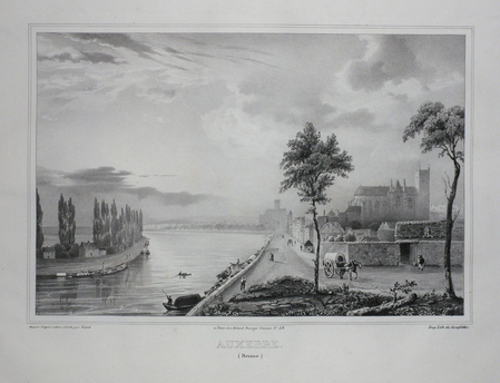
VIARD;
AUXERRE (Yonne).
Paris Benard circa 1850 220 x 291 mm.
Bookseller reference : LBW03d59
|
|
|
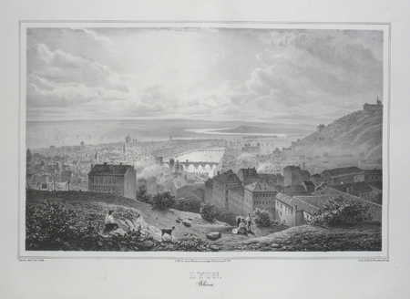
VIARD.
LYON (Rhône).
Paris, Benard, [circa 1850]. 217 x 302 mm.
Bookseller reference : LBW03d52
|
|
|
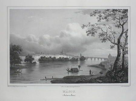
VIARD;
MACON (Saône et Loire).
Paris Benard circa 1850 210 x 289 mm.
Bookseller reference : LBW03d50
|
|
|
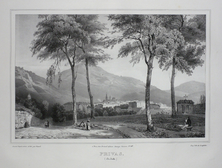
VIARD;
PRIVAS (Ardèche).
Paris Benard circa 1850 225 x 298 mm.
Bookseller reference : LBW03d60
|
|
 Receive by email
 Download as PDF document
 RSS feed


