|
Time Traveler Maps Creator
The Colorado Plateau: Map & Guide to Public Lands on the Colorado Plateau & its Borderlands
Time Traveler Maps 2004-06-01. 2nd. Map. Used:Good. Time Traveler Maps unknown
Bookseller reference : DADAX1892040166 ISBN : 1892040166 9781892040169
|
|
|
Tirion Isaak Pugsley William H. William Howard donor WH. Pugsley Collection of Early Canadian Maps W. H.
Nieuwe kaart van kanada : de landen aan de Hudsons-Baay en de noordwestelyke deelen van Noord-Amerika 1769 Leather Bound
2019. Leather Bound. New. Leather Binding on Spine and Corners with Golden Leaf Printing on round Spine extra customization on request like complete leather Golden Screen printing in Front Color Leather Colored book etc. Reprinted in 2019 with the help of original edition published long back 1769. This book is printed in black & white sewing binding for longer life Printed on high quality Paper re-sized as per Current standards professionally processed without changing its contents. As these are old books we processed each page manually and make them readable but in some cases some pages which are blur or missing or black spots. If it is multi volume set then it is only single volume if you wish to order a specific or all the volumes you may contact us. We expect that you will understand our compulsion in these books. We found this book important for the readers who want to know more about our old treasure so we brought it back to the shelves. Hope you will like it and give your comments and suggestions. Lang: - Dutch. EXTRA 10 DAYS APART FROM THE NORMAL SHIPPING PERIOD WILL BE REQUIRED FOR LEATHER BOUND BOOKS. COMPLETE LEATHER WILL COST YOU EXTRA US$ 25 APART FROM THE LEATHER BOUND BOOKS. hardcover
Bookseller reference : LB1111007011002
|
|
|
Tirion Isaak Pugsley William H. William Howard donor WH. Pugsley Collection of Early Canadian Maps W. H.
Nieuwe kaart van kanada : de landen aan de Hudsons-Baay en de noordwestelyke deelen van Noord-Amerika 1769 FULL LEATHER BOUND
2019. SUPER DELUXE EDITION. New. Antique look with Golden Leaf Printing and embossing with round Spine completely handmade bindingextra customization on request like Color Leather Colored book special gold leaf printing etc. Reprinted in 2019 with the help of original edition published long back 1769. This book is printed in black & white sewing binding for longer life Printed on high quality Paper re-sized as per Current standards professionally processed without changing its contents. As these are old books we processed each page manually and make them readable but in some cases some pages which are blur or missing or black spots. If it is multi volume set then it is only single volume if you wish to order a specific or all the volumes you may contact us. We expect that you will understand our compulsion in these books. We found this book important for the readers who want to know more about our old treasure in old look so we brought it back to the shelves. Hope you will like it and give your comments and suggestions. Lang: - Dutch. EXTRA 10 DAYS APART FROM THE NORMAL SHIPPING PERIOD WILL BE REQUIRED. Normal Hardbound Edition is also available on request. unknown
Bookseller reference : SD1111007011002
|
|
|
Tirion Isaak Pugsley William H. William Howard donor WH. Pugsley Collection of Early Canadian Maps W. H.
Nieuwe kaart van kanada : de landen aan de Hudsons-Baay en de noordwestelyke deelen van Noord-Amerika 1769
2019. Paperback. New. Lang: - Dutch. Reprinted in 2019 with the help of original edition published long back 1769. This book is Printed in black & white sewing binding for longer life with Matt laminated multi-Colour Soft Cover HARDCOVER EDITION IS ALSO AVAILABLE Printed on high quality Paper re-sized as per Current standards professionally processed without changing its contents. As these are old books we processed each page manually and make them readable but in some cases some pages which are blur or missing or black spots. If it is multi volume set then it is only single volume if you wish to order a specific or all the volumes you may contact us. We expect that you will understand our compulsion in these books. We found this book important for the readers who want to know more about our old treasure so we brought it back to the shelves. Any type of Customisation is possible with extra charges. Hope you will like it and give your comments and suggestions. paperback
Bookseller reference : PB1111007011002
|
|
|
Tirion Isaak Pugsley William H. William Howard donor WH. Pugsley Collection of Early Canadian Maps W. H.
Nieuwe kaart van kanada : de landen aan de Hudsons-Baay en de noordwestelyke deelen van Noord-Amerika 1769 Hardcover
2019. Hardcover. New. Lang: - Dutch. Reprinted in 2019 with the help of original edition published long back 1769. This book is Printed in black & white Hardcover sewing binding for longer life with Matt laminated multi-Colour Dust Cover Printed on high quality Paper re-sized as per Current standards professionally processed without changing its contents. As these are old books we processed each page manually and make them readable but in some cases some pages which are blur or missing or black spots. If it is multi volume set then it is only single volume if you wish to order a specific or all the volumes you may contact us. We expect that you will understand our compulsion in these books. We found this book important for the readers who want to know more about our old treasure so we brought it back to the shelves. Any type of Customisation is possible with extra charges. Hope you will like it and give your comments and suggestions. hardcover
Bookseller reference : 1111007011002
|
|
|
TIRION (Isaak).
[MARTINIQUE] Het westindisch eiland Martenique.
Amsterdam, [circa 1760]. 309 x 368 mm.
Bookseller reference : LBW-4527

|
|
|
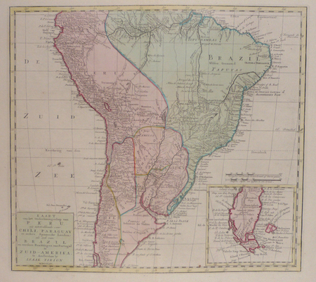
TIRION (Isaak).
Kaart van het onderkoningschap van Peru, ... Chili, Paraguay ... Brazil ... in Zuid-Amerika.
Amsterdam, 1765. 360 x 398 mm.
Bookseller reference : LBW02482
|
|
|
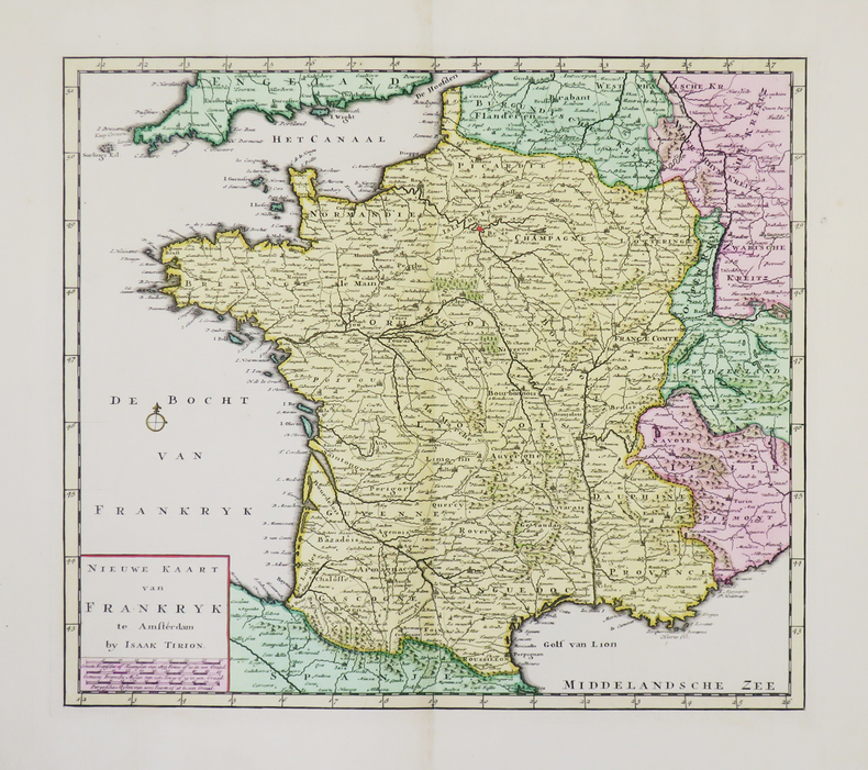
TIRION (Isaak).
Nieuwe kaart van Frankryk.
Amsterdam, [circa 1730]. 329 x 375 mm.
Bookseller reference : LBW-4941
|
|
|
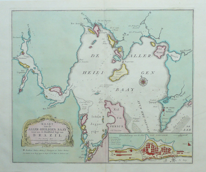
TIRION (Isaak);
[BRESIL] Kaart van de aller-heiligen baay waar aan de Hoofdstad legt van Brazil.
Amsterdam circa 1760 344 x 407 mm.
Bookseller reference : LBW-1307
|
|
|
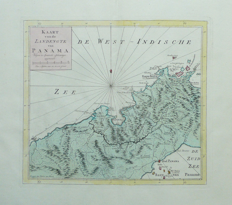
TIRION (Isaak);
[PANAMA] Kaart van de landengte van Panama.
Amsterdam circa 1760 270 x 303 mm.
Bookseller reference : LBW-1366
|
|
|
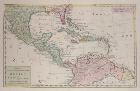
TIRION (Isaak);
Kaart van de onderkoningschappen van Mexico en Nieuw Granada in de Spaansche West-Indien.
Amsterdam 1765 298 x 476 mm.
Bookseller reference : LBW024ac
|
|
|
TIRION (Isaak);
Nieuwe kaart van het westelykste deel der weereld ... naar Westindie.
Amsterdam 1754 340 x 362 mm.
Bookseller reference : LBW0247b
|
|
|
TIRPENNE & MONTHELIER.
LYON (Rhône).
Paris, Benard, [circa 1850]. 221 x 292 mm.
Bookseller reference : LBW03d51

|
|
|
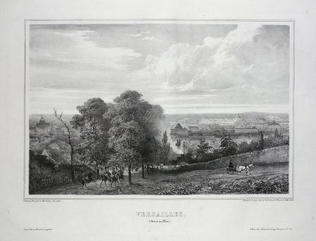
TIRPENNE & MONTHELIER.
VERSAILLES (Seine et Oise).
Paris, Benard, [circa 1850]. 222 x 293 mm.
Bookseller reference : LBW03d74
|
|
|
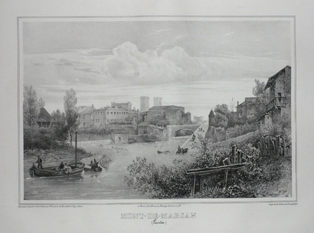
TIRPENNE;MONTHELIER;
MONT-DE-MARSAN (Landes).
Paris Benard circa 1850 221 x 295 mm.
Bookseller reference : LBW03d6e
|
|
|
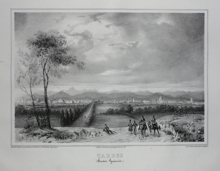
TIRPENNE;MONTHELIER;
TARBES (Hautes Pyrénnées).
Paris Benard circa 1850 219 x 281 mm.
Bookseller reference : LBW03d5d
|
|
|
TISSOT
Tours de cartes, recueil complet
Paris Delarue s.d. (vers 1890) in-8 br., couv. illustrée
Bookseller reference : 17049
|
|
|
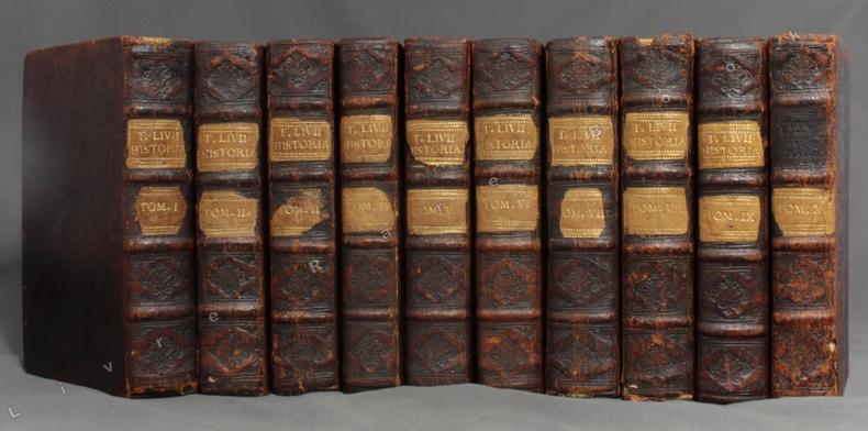
TITE-LIVE; CLERICUS Joannes (préf. et notes):
Titi Livii historiarum quod exstat, cum integiris Joannis Freinshemii supplementis...
Amstelaedami, Apud Henricum Wetstenium, 1710. 10 vol. in-8 de [30]-455 + 490 + 470 + 446 + 460 + 495 + 506 + 496 + 504 + 363 pages. Pleine basane marron, dos à nerfs ornés de filets et fleurons à froid, pièces de titre et tomaison blondes. Dos frottés, accroc aux coiffes sup. des vol. 1 et 7, accroc aux coiffes inf. des vol. 1 et 8, coiffe inf. vol. 7 manquante, mors 1er plat fendus en leur part. inf. sur les vol. 7 et 10, pièce de titre manquante au vol. 10.
Bookseller reference : 2869
|
|
|
TOCQUET Robert
La prestidigitation à la porté de tous.
Paris, N.O.E., 1977. 14 x 22, 191 pp., broché, état moyen (couverture défraîchie).
Bookseller reference : 36707
|
|
|
TOCQUET Robert
Les tours de carte à la porté de tous.
Paris, N.O.E., 1977. 14 x 22, 189 pp., broché, état moyen (couverture défraîchie).
Bookseller reference : 36708
|
|
|
TOCQUET Robert
LES TOURS DE CARTES A LA PORTEE DE TOUS
1977 broché in-octavo, couverture recto ornée dune illustration photographique, illustrations : frontispice et figures in-texte, 189 pages, 1977 Paris Productions de Paris-N.O.E.,
Bookseller reference : 5315
|
|
|
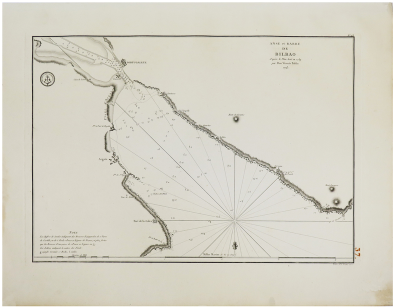
TOFIÑO de SAN MIGUEL (Don Vicente).
[PAYS BASQUE] Anse et barre de Bilbao d'après le plan levé en 1789 par Don Vicente Tofiño. 1793.
1793. 367 x 523mm.
Bookseller reference : LBW-1807
|
|
|
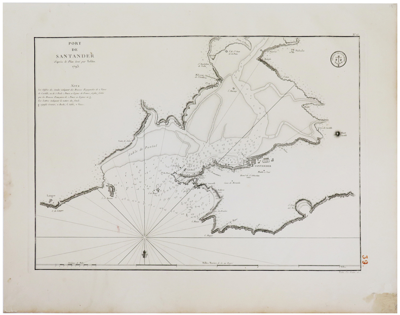
TOFIÑO de SAN MIGUEL (Don Vicente).
[PAYS BASQUE] Port de Santander d'après le plan levé par Tofiño. 1793.
1793. 372 x 526 mm.
Bookseller reference : LBW-1804
|
|
|
TOFIÑO de SAN MIGUEL (Don Vicente).
[PAYS BASQUE] Port de Santoña d'après le plan levé en 1789 par Tofiño. 1793.
1793. 372 x 527 mm.
Bookseller reference : LBW-1803

|
|
|
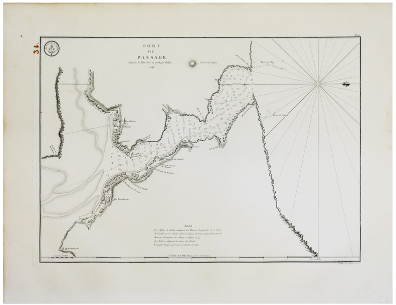
TOFIÑO de SAN MIGUEL (Don Vicente).
[PAYS BASQUE] Port du Passage d'après le plan levé en 1788 par Tofiño. 1793.
1793. 369 x 525 mm.
Bookseller reference : LBW-1806
|
|
|
Togni, Roberto - Forni, Gaetano - Pisani, Francesca
Guida ai musei etnografici italiani. Agricoltura, pesca, alimentazione e artigianato.
cm. 17 x 24, 340 pp. con 269 ill. n.t. di cui 47 a colori. Biblioteca di ?Lares? Il sorgere in qualche decennio di molte centinaia di musei attinenti le tradizioni popolari costituisce il pi? straordinario processo di musealizzazione di tutti i tempi. Qui per la prima volta viene analizzato, sotto il profilo storico-antropologico con ampissimo respiro pluridisciplinare, il loro ricco contenuto e, per ciascuno di essi, vengono fornite le caratteristiche e le informazioni logistiche essenziali. N? viene tralasciata una sintetica comparazione con i musei di questi tipo degli altri Paesi. Un manuale prezioso per le pi? diverse categorie di specialisti: museologi, etnologi, insegnanti, amministratori pubblici, architetti, storici ecc. The birth of several hundred museums pertaining to popular traditions within a matter of decades constitutes the most extraordinary process of 'museum-consciousness' of all times. For the first time under an historical-anthropological profile with ample multi-disciplinary views their rich contents are closely examined and their distinctive features plus essential logistical information are provided for each one. A synthetic comparison between similar museums in other countries is also included. A precious manual for the various categories of specialists: museum scholars, ethnologists, teachers, public administrators, architects, historians etc. 801 gr. 340 p.
|
|
|
Toland John author; Kuhl Jerome maps
THE BATTLE OF THE BULGE LANDMARK BOOKS 114
New York: Landmark Books Random House 1966. Hardcover. Octavo; G-/no DJ; Hardcover w/out DJ; Spine white with red print; Boards in illustrated cloth wear to corners and spine caps toning to spine edgewear/shelfwear; Text block has name in ink on front endpapers cracked hinges front and rear clean text light age-toning to paper; 178 pages frontispiece illustrated b&w. FP New Rockville Stock. <br/><br/> Landmark Books, Random House hardcover
Bookseller reference : 15-81-1326637
|
|
|
Toland John author; Kuhl Jerome maps
THE BATTLE OF THE BULGE LANDMARK BOOKS 114
New York: Landmark Books Random House 1966. Hardcover. Octavo; G-/no DJ; Hardcover w/out DJ; Spine white with red print; Boards in illustrated cloth wear to corners and spine caps toning to spine edgewear/shelfwear; Text block has name in ink on front endpapers cracked hinges front and rear clean text light age-toning to paper; 178 pages frontispiece illustrated b&w. 1326637. FP New Rockville Stock. Landmark Books, Random House hardcover books
Bookseller reference : 1326637
|
|
|
Tolkien J R R And Tolkien Christopher Introduction Commentary Index Maps
Unfinished Tales of Numenor and Middle-Earth
Houghton Mifflin Company 1980 Illus. by LRShelf. American ed. Hard cover. Very Good. Very Good in Fair jacket Very good in fair dust jacket. Inconsequential staining on rear board adjacent to spine. Sewn binding. Green cloth-bound with silver and metallic-green on spine and front cover. 472 p. LRShelf; First printing of First American edition. Foldout map attached to RFEP. DJ has edge nicks moisture wrinkles and staining on inside. Houghton Mifflin Company hardcover
Bookseller reference : Alibris.0001591 ISBN : 0395299179 9780395299173

|
|
|
Tolkien J. R. R. Edited With Intro. Commentary Index Maps By Christopher Tolkien
Unfinished Tales
NY: Houghton Mifflin 1980 1980. First US Edition. Cloth 8vo 472 pp. foldout map at rear. Very Good w. covers a bit dull spine slightly cocked tiny bottom edge stain page edges dusty; in jacket w. spine faded a few tiny chips and closed edge tears. 1st Edition. Hardcover. NY: Houghton Mifflin, 1980 Hardcover
Bookseller reference : B2309
|
|
|
TOLOMEO Claudio
LA GEOGRAFIA… nuovamente tradotta di greco in italiano da Girolamo Ruscelli
In 4° (234 x 163 mm), 3 parti in 1 volume.; [8], 358, [2] pagine; [28] carte; 47, [49] pagine, 64 carte geografiche a doppia pagina delle quali 27 raffiguranti il mondo antico e 37 raffiguranti il mondo moderno con la descrizione al retro, 12 xilografie e diagrammi nel testo, marche tipografiche (alcuni difetti.). Solida legatura coeva in pergamena con unghie (sguardie nuove).

|
|
|
Tolomeo, Claudio (Ptolomaeus, Claudius)
Ptolemaei Tabulae cosmographicae. Volume primo: Facsimile dell edizione del 1486. Volume secondo: Studio e traduzione
<p>2 volumi in folio atlantico, 42 cm, rilegatura in carta pergamenta con titoli e fregi impressi a secco, cofanetto editoriale in seta con illustrazione e titolo in oro. Vol. I: (c. 200 n.n); Vol. II: X, 307 , . Il primo volume stampato a 5 colori su carta filigranata è la riproduzione anastatica dell'edizione incunabula del 1486 con numerose illustrazioni e carte geografiche anche a doppia pagina. Il secondo volume "Studio e Traduzione" a cura di Sante Bortolani. Edizione di pregio, rilegata a mano e limitata a 2999 esemplari (il nostro n°1238)<strong></strong></p>

|
|
|
Tom Harrison Maps
Ansel Adams Wilderness Trail Map Tom Harrison Maps
2015-04-04. New. Ships with Tracking Number! INTERNATIONAL WORLDWIDE Shipping available. May be re-issue. Buy with confidence excellent customer service! unknown
Bookseller reference : 0981834426n ISBN : 0981834426 9780981834429

|
|
|
Tom Harrison Maps; Tom Harrison Editor; Tom Harrison Illustrator;
Ansel Adams Wilderness Trail Map Tom Harrison Maps
Marketscope Books 2010-05-01. Map. Used:Good. Marketscope Books unknown
Bookseller reference : DADAX0981834426 ISBN : 0981834426 9780981834429

|
|
|
Tom Harrison Maps
Cuyamaca Rancho State Park Trail Map Tom Harrison Maps
2003-09-04. New. Ships with Tracking Number! INTERNATIONAL WORLDWIDE Shipping available. May be re-issue. Buy with confidence excellent customer service! unknown
Bookseller reference : 1877689793n ISBN : 1877689793 9781877689796

|
|
|
Tom Harrison Maps
Cuyamaca Rancho State Park Trail Map
Marketscope Books 2003-06-06. Map. Good. Marketscope Books unknown
Bookseller reference : SONG1877689793 ISBN : 1877689793 9781877689796
|
|
|
Tom Harrison Maps
Death Valley National Park Recreation Map
Marketscope Books 2008-10-01. Map. Used:Good. Marketscope Books unknown
Bookseller reference : DADAX1877689572 ISBN : 1877689572 9781877689574
|
|
|
Tom Harrison Maps Firm
Emigrant Wilderness Trail Map: Shaded-relief topo map
Marketscope Books 2002-01-02. Unknown Binding. Good. Marketscope Books unknown
Bookseller reference : SONG1877689734 ISBN : 1877689734 9781877689734
|
|
|
Tom Harrison Maps Firm
Half Dome: Glacier Point Yosemite Creek Tenaya Lake Little Yosemite Valley trail map Tom Harrison Maps
2000-04-03. New. Ships with Tracking Number! INTERNATIONAL WORLDWIDE Shipping available. May be re-issue. Buy with confidence excellent customer service! unknown
Bookseller reference : 187768970Xn ISBN : 187768970x 9781877689703

|
|
|
Tom Harrison Maps Firm
Half Dome: Glacier Point Yosemite Creek Tenaya Lake Little Yosemite Valley trail map
Marketscope Books 2000-01-02. Map. Good. Marketscope Books unknown
Bookseller reference : SONG187768970X ISBN : 187768970X 9781877689703
|
|
|
Tom Harrison Maps
Joshua Tree National Park Recreation Map Tom Harrison Maps
2010-02-01. New. Ships with Tracking Number! INTERNATIONAL WORLDWIDE Shipping available. May be re-issue. Buy with confidence excellent customer service! unknown
Bookseller reference : 187768953Xn ISBN : 187768953x 9781877689536

|
|
|
Tom Harrison Maps
Joshua Tree National Park Recreation Map
Marketscope Books 2010-03-01. Map. Used:Good. Marketscope Books unknown
Bookseller reference : DADAX187768953X ISBN : 187768953X 9781877689536

|
|
|
Tom Harrison Maps Firm
Lake Tahoe Recreation Map
Tom Harrison Maps 2007. Map. New. 2nd edition. 1 pages. 9.40x4.40x0.20 inches. Tom Harrison Maps unknown
Bookseller reference : 2-1877689599 ISBN : 1877689599 9781877689598
|
|
|
Tom Harrison Maps Firm Tom Harrison Editor Tom Harrison Illustrator
Lake Tahoe Recreation Map
Marketscope Books 2009-01-14. 2. Map. Good. Marketscope Books unknown
Bookseller reference : SONG1877689599 ISBN : 1877689599 9781877689598
|
|
|
Tom Harrison Maps
Malibu Creek State Park Trail Map Tom Harrison Maps
2005-02-01. New. Ships with Tracking Number! INTERNATIONAL WORLDWIDE Shipping available. May be re-issue. Buy with confidence excellent customer service! unknown
Bookseller reference : 1877689866n ISBN : 1877689866 9781877689864

|
|
|
Tom Harrison Maps
Malibu Creek State Park Trail Map
Marketscope Books 2005-01-02. Map. Good. Marketscope Books unknown
Bookseller reference : SONG1877689866 ISBN : 1877689866 9781877689864
|
|
|
Tom Harrison Maps Firm Tom Harrison Editor Tom Harrison Illustrator
Mammoth high country trail map: Waterproof tearproof
Marketscope Books 2008-09-26. 2. Map. Good. Marketscope Books unknown
Bookseller reference : SONG1877689564 ISBN : 1877689564 9781877689567
|
|
|
Tom Harrison Maps
Mineral King Trail Map: Bearpaw Meadow Franklin Pass Little Five Lakes Hockett Meadow High Sierra Trail Funston Meadow Silver City Chag
Marketscope Books 2004-07-01. Map. Used:Good. Marketscope Books unknown
Bookseller reference : SONG1877689831 ISBN : 1877689831 9781877689833
|
|
|
Tom Harrison Maps Firm
Mono Divide high country trail map
Hourglass Book Pub 1999. Map. New. 1 pages. 7.00x4.50x0.30 inches. Hourglass Book Pub unknown
Bookseller reference : 2-1877689467 ISBN : 1877689467 9781877689468
|
|
|
Tom Harrison Maps
Mono Divide high country trail map Tom Harrison Maps
Tom Harrison Maps 2011-01-04. Map. Used:Good. Tom Harrison Maps unknown
Bookseller reference : DADAX1877689467 ISBN : 1877689467 9781877689468
|
|
 Receive by email
 Download as PDF document
 RSS feed


