|
Sakkas George K.
Crete in Colour : A Tourist Guide Book.
Athens: Artemis Pub 1972 Short interesting guide book to Crete. Pbk. 120p. plates some col. maps of Crete and street map of Iraklion. Very Good. Artemis Pub unknown
Bookseller reference : 14736
|
|
|
Sakkas George K.
Crete in Colour : A Tourist Guide Book.
Athens: Artemis Pub 1972 Short interesting guide book to Crete. Pbk. 120p. plates some col. maps of Crete and street map of Iraklion Condition : Good. Very Good. Artemis Pub unknown
Bookseller reference : 14737
|
|
|
Sakkas George K.
Crete in Colour : A Tourist Guide Book.
Athens: Artemis Pub 1972 Short interesting guide book to Crete. Pbk. 120p. plates some col. maps of Crete and street map of Iraklion. Very Good. Artemis Pub unknown
Bookseller reference : 14735
|
|
|
Sakkas,George K.
Crete in Colour : A Tourist Guide Book.
Short interesting guide book to Crete. 120p. plates (some col.) maps of Crete and street map of Iraklion. Vintage copyY) Book
|
|
|
Sale, Richard ; Rudd, Peter
The Visitor's Guide to the Italian Lakes
No marks or inscriptions to contents. A very clean very tight copy with bright unmarked red cloth boards, discolouration to small part of upper rear corner and no bumping to corners. Dust jacket price clipped but not marked or torn or creased with general traces of storage. 256pp. Detailed guide to the Italian Lakes - Orta, Maggiore, Lugano, Como and Garda and the surrounding area. Well illustrated.

|
|
|
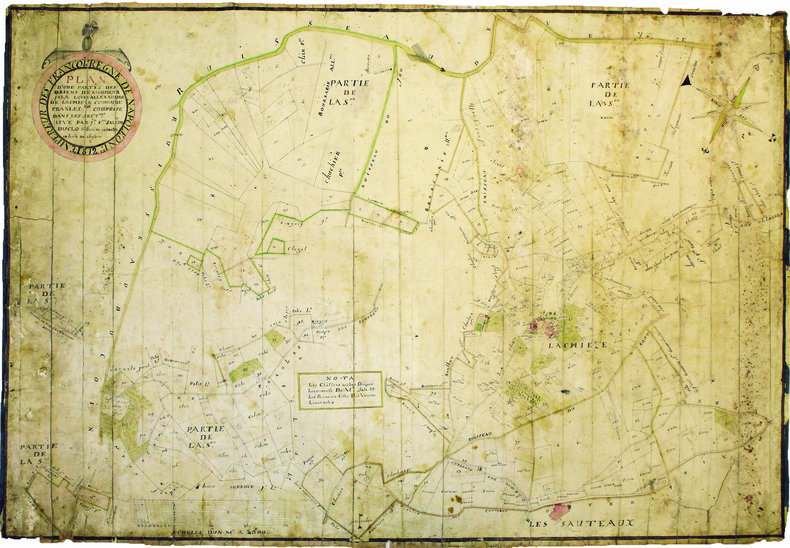
SALEON DUCLO (Jean-François). MANUSCRIT.
Plan d'une partie des biens de monsieur Jala Louis Allexandre de Lachieze, commune de Pranles comprise dans les sectons levé par Jn Fois Saléon Duclo géomètre du cadastre de la ville de Cheylard.
1812. 560 x 825 mm.
Bookseller reference : LBW-4182
|
|
|
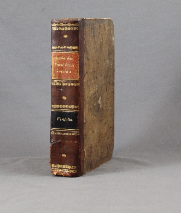
SALMON Thomas:
Lo stato presente du tutti i paesi, e popoli del mondo naturale, politico, e morale, con nuove osservazioni, e correzioni degli antichi, e moderni viaggiatori. Volume X. Dei circoli susseguenti dell'Imperio, cioe' Svevia, alto, e basso Reno, e Vestfalia e delle dieci provincie dei Paesi Bassi austriaci, e francesi.
Venezia, Giambatista Albrizzi, 1740. In-8 de [12]-502-[2]p. demi-basane brune, dos lisse, filets et fleurons dorés, pièces de titre et tomaison noir et orange (un mors fendu tristement recollé, coins tapés, rousseurs, annotations).
Bookseller reference : 6334
|
|
|
Salvador, I.
Geschichte der RÖmerherrschaft in JudÄa und der ZerstÖrung Jerusalems [Vol. 2 ONLY]
[Vol.2 ONLY]. 8' 483pp. glit hardcover. cover slightly worn. ex library with usual words. a few pencil marks on inner cover. some aging marks on pages. a couple of maps added. else in fair condition.
|
|
|
Samson, Pet. Heinr. [Peter Heinrich]
Die Entwickelung der Freien und Hansestadt Hamburg von der Entstehung bis auf die Gegenwart in geschichtl. Grundzügen, Sagen u. Biographien, nach den Quellen chronologisch geordnet.
Hamburg, Carl Pottier, 1886. VIII, 119 S. Mit 1 gefalt. farb. lithograph. Straßenplan. HLn. d. Zt.
Bookseller reference : 17370

|
|
|
Samuel Bagster
ILLUSTRATIONS TO THE HOLY SCRIPTURES Consisting of Eighteen Maps and Plans
London: Samuel Bagster and Sons 1856. Undated but Plan of Jerusalem dated 1837 and inscription to the front free end paper dated 1859 Copac suggests 1856. The maps state "Engraved for Bagster's English Version of the Polyglott Bible" and have evidently been borrowed from that work to make up this small book of maps. Title page explanatory list; follwed by 12 leaves of engraved maps printed to one side only consisting of double and single page maps most of which hand-coloured. All present in accordance with the explanatory list but not bound in the same order. Original red-coated end papers all edges dyed red. Original quarter tan morocco over pink cloth boards with gilt lettering to the upper board. Very good a few ink marks - more so to the rear board. Contents good and tight all maps in very good clean condition the small private stamp of H. E. Spencer near contemporary has been liberally applied to the front blank and title pages. A very good copy - scarce Copac lists only three copies. Hard Cover. Very Good. 12mo. Samuel Bagster and Sons Hardcover
Bookseller reference : 023880

|
|
|
Samuel Eliot & Commager Henry Steele Morrison Morison; Illustrator Maps Photos
The Growth Of The American Republic: Volume Two.
Oxford University Press 1942. Hardcover. Acceptable. Disclaimer:A readable copy. All pages are intact and the cover is intact. Pages can include considerable notes-in pen or highlighter-but the notes cannot obscure the text. At ThriftBooks our motto is: Read More Spend Less.Dust jacket quality is not guaranteed. Oxford University Press hardcover
Bookseller reference : GB00226EPM4I5N00

|
|
|
Samuel Merwin endpapers of maps with former owner stamp & some fox Beautiful coloured frontispiece with small stain at top pag
Silk A Legend as narrated in the journals & correspondence of Jan Po
Houghton Mifflin Printed in Great Britain. HBNoDJ 1923 1st editionGreen Silk Covers lettered in Gold GiltCover some stains & small amount clear tape & some wear Hinge starting slightly interior Nice & TightVG-/G- AS-IS NODJ. Houghton Mifflin, Printed in Great Britain unknown
Bookseller reference : 7552
|
|
|
Sanborn Anne Fay; Maps Illustrator
Transylvania and the Hungarian-Rumanian Problem: A Symposium Compiled by the Danubian/Research and Information Center. Ed by Anne Fay Sanborn
Danubian Pr 1979-09-01. Hardcover. Very Good. Hardcover no marks noted in text no dj cover stainedAND AS ALWAYS SHIPPED IN 24 HOURS; and emailed to you a USPS tracking number on all orders; all books are sanitized and cleaned for your protection before mailing Danubian Pr hardcover
Bookseller reference : 121120020 ISBN : 0879340215 9780879340216
|
|
|
Sanborn Anne Fay; Maps Illustrator
Transylvania and the Hungarian-Rumanian Problem: A Symposium Compiled by the Danubian/Research and Information Center. Ed by Anne Fay Sanborn
Danubian Pr 1979-09-01. Hardcover. Very Good. Hardcover with dj no marks noted in textAND AS ALWAYS SHIPPED IN 24 HOURS; and emailed to you a USPS tracking number on all orders; all books are sanitized and cleaned for your protection before mailing Danubian Pr hardcover
Bookseller reference : 121120024 ISBN : 0879340215 9780879340216
|
|
|
SANDBY (Thomas) & SANDBY (Paul).
[GRAND PARC de WINDSOR] View from the north side of the Virginia river, near the Manour Lodge.
London, John Boydell, March the 2.d 1772. 335 x 563 mm.
Bookseller reference : LBW-6246

|
|
|
SANDEMANN;
ORLEANS (Loiret).
Paris Benard circa 1850 216 x 295 mm.
Bookseller reference : LBW03d6b

|
|
|
Sanderson Ivan T. chapter head drawings by F. Enderoth Saunders maps and charts by the author Dust Wrapper design by Samuel H.
FOLLOW THE WHALE
Boston: Little Brown and Company 1956. Fair in Fair dust jacket. 1956. First Edition. Hardcover. First edition stated. "From time immemorial man has pursued the whale. This is the story of the peoples who have engaged in that pursuit---its historical cultural and economic consequences". 423 pages illustrated with maps including the endpapers charts and drawings general whaling chronology note on maps appendixes bibliography by periods and subjects index. Otherwise VG copy light wear very light bumping to some corners with owner's name and date to the front free endpaper and pencil annotations to the margins of a dozen or two pages scattered throughout the book in worn/torn/chipped especially to the spine head/etc Good at best Dust Wrapper. . Little Brown and Company [1956] hardcover
Bookseller reference : 53121

|
|
|
SANDMANN.
MELUN (Seine et Marne).
Paris, Benard, [circa 1850]. 212 x 298 mm.
Bookseller reference : LBW03d75
|
|
|
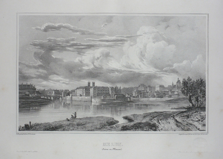
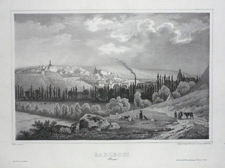
SANDMANN;
BAR-LE-DUC (Meuse).
Paris Benard circa 1850 222 x 295 mm.
Bookseller reference : LBW03d58
|
|
|
SANDMANN;
LILLE (Nord).
Paris Benard circa 1850 225 x 292 mm.
Bookseller reference : LBW03d78
|
|
|
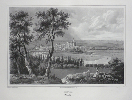
SANDMANN;
METZ (Moselle).
Paris Benard circa 1850 224 x 292 mm.
Bookseller reference : LBW03d4f
|
|
|
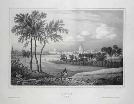
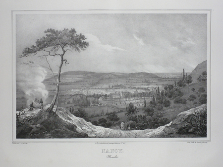
SANDMANN;
NANCY (Meurthe).
Paris Benard circa 1850 218 x 293 mm.
Bookseller reference : LBW03d4e
|
|
|
SANDMANN;
STRASBOURG (Bas-Rhin).
Paris Benard circa 1850 217 x 294 mm.
Bookseller reference : LBW03d4d

|
|
|
SANDRART Joachim von (Francoforte 1606 - Norimberga 1688)
Recentis Romae Ichonographia ...
Grande pianta della città, stampata su due fogli reali, copia di quella realizzata da Giovan Battista Falda nel 1667 per papa Alessandro VII. Pianta a proiezione mista, orientata con il nord a sinistra. Topograficamente la carta del Sandrart è fedele a quella del Falda; le modifiche sostanziali sono nei cartigli, con le scritte in tedesco, e nella dedica a papa Innocenzo XI. Il cartiglio di destra raffigura gli stemmi dei Rioni, mentre in basso al centro sono incise delle piccole vedute delle sette chiese giubilari. Incisa a quattro mani con Johannes Meyer, questa pianta risulta per l’eleganza del segno, più raffinata rispetto al Falda, intagliata dal francese Lhuiler. "Copia della pianta piccola del Falda incisa dal Meyer che si firma in basso a sinistra Iohann Meyer fecit Tiguri. IN alto a sinistra, in luogo della dedica fatta dal Falda ad Alessandro VII, compare quella ad Innocenzo XI (1676-89) con la data 1677 e più in basso il nome di Ioachini Sandrart. La pianta è probabilmente anche contenuta nell'opera del Sandrart Der Alten und neue, pubblicata a Norimberga nel 1768" (cfr. Marigliani p. 219). Acquaforte, con margini, in eccellente stato di conservazione. Rara. Large plan of the city, printed on two real sheets, copy of the one made by Giovan Battista Falda in 1667 for Pope Alexander VII. Mixed projection map, oriented with north on the left. Topographically, Sandrart's map is faithful to Falda's; the substantial changes are in the cartouches, with the German inscriptions, and in the dedication to Pope Innocezo XI. The right-hand cartouche depicts the coats of arms of the Rioni, while small views of the seven Jubilee churches are engraved in the bottom centre. Engraved by four hands with Johannes Meyer, this plan is more refined in the elegance of its sign than the Falda, carved by the Frenchman Lhuiler. "Copy of Falda's small plan engraved by Meyer, signed at lower left Iohann Meyer fecit Tiguri. In the upper left corner, instead of the dedication made by Falda to Alexander VII, the dedication to Innocent XI (1676-89) appears with the date 1677 and lower down the name of Ioachini Sandrart. The plan is probably also contained in Sandrart's work Der Alten und neue, published in Nuremberg in 1768' (cf. Marigliani p. 219). Sandrart carved this plan together with Johannes Meyer; the result is a far more refained work compared to that of Falda, carved by Lhuiler. Etching, with margins, in excellent condition. Rare. Huelsen (1915): n. 119; Scaccia Scarafoni (1939): n. 200; A. P. Frutaz, "Le piante di Roma", CLVI ; TIB p. 317, 281 C1. C. Marigliani, "Le Piante di Roma delle collezioni private", tav. 126.

|
|
|
SANDS M. Et Mme H. et BOLAND Henri
Guides-Joanne : Angleterre , Écosse , Irlande . Complet De Sa Carte Indépendante En Fin D'ouvrage
Paris - Londres - New York Hachette & Cie 1908 In 16 Collection " Des Guides-Joanne " avec 7 plans et 10 cartes en couleurs dont certaines dépliantes . Nombreuses publicités , notamment d'hôtels mais aussi de Michelin , de chocolat Menier etc . Illustré de photographies en noir et blanc .- 190 p. + 152 p. , 450 gr.
Bookseller reference : 015241

|
|
|
SANDS M. Et Mme H. et BOLAND Henri
Guides-Joanne : Angleterre , Écosse , Irlande . Complet De Sa Carte Indépendante En Fin D'ouvrage
Collection " Des Guides-Joanne " avec 7 plans et 10 cartes en couleurs dont certaines dépliantes . Nombreuses publicités , notamment d'hôtels mais aussi de Michelin , de chocolat Menier etc . Illustré de photographies en noir et blanc .- 190 p. + 152 p. , 450 gr.

|
|
|
sans auteur
CARTE DEPARTEMENTALE DE LOIRE-ATLANTIQUE
1970 carte papier en couleurs (map in paper in colours) - repliée sous une chemise orange éditeur in-octavo (folding under editor jacket), couverture imprimée (cover printed), dimensions (size in Inches) : 75,50 centimètres de largeur (width : 29,72) sur 56 de hauteur (height :22,04 ), sans date (les années 1950) à Paris Editions Géographiques André Lesot - Imprimerie Gaillac-Monrocq et Compagnie,
Bookseller reference : 9208
|
|
|
sans auteur
L'AVENIR PAR LES CARTES
1973 broché (paperback) in-octavo, dos blanc (white spine), première de couverture illustrée en couleurs (front cover illustrated in colours), tranches lisses (edges smooth), sans illustration (no illustration), 189 pages, 1973 à Paris Editions Albin Michel,
Bookseller reference : 10988
|
|
|
sans nom
PUZZLE VINTAGE LAROUSSE DU XXEME SIECLE carte n°32 EUROPE et n°33 AFRIQUE
Larousse, 1950 environ, boite en bon état ( arêtes des coins frottées) contenant 2 puzzles en bois: l'Afrique et l'Europe. Ce sont les cartes du Larousse du XXeme siecle. Les puzzles sont en excellent état, et complets.
Bookseller reference : 8820
|
|
|
Sanson Nicolas Pugsley William H. William Howard donor WH. Pugsley Collection of Early Canadian Maps W. H.
Le Canada ou Nouvelle France &c. : tiree de diverses relations des Francois Anglois Hollandois &c. 1667 Leather Bound
2019. Leather Bound. New. Leather Binding on Spine and Corners with Golden Leaf Printing on round Spine extra customization on request like complete leather Golden Screen printing in Front Color Leather Colored book etc. Reprinted in 2019 with the help of original edition published long back 1667. This book is printed in black & white sewing binding for longer life Printed on high quality Paper re-sized as per Current standards professionally processed without changing its contents. As these are old books we processed each page manually and make them readable but in some cases some pages which are blur or missing or black spots. If it is multi volume set then it is only single volume if you wish to order a specific or all the volumes you may contact us. We expect that you will understand our compulsion in these books. We found this book important for the readers who want to know more about our old treasure so we brought it back to the shelves. Hope you will like it and give your comments and suggestions. Lang: - freeng. EXTRA 10 DAYS APART FROM THE NORMAL SHIPPING PERIOD WILL BE REQUIRED FOR LEATHER BOUND BOOKS. COMPLETE LEATHER WILL COST YOU EXTRA US$ 25 APART FROM THE LEATHER BOUND BOOKS. hardcover
Bookseller reference : LB1111007010808
|
|
|
Sanson Nicolas Pugsley William H. William Howard donor WH. Pugsley Collection of Early Canadian Maps W. H.
Le Canada ou Nouvelle France &c. : tiree de diverses relations des Francois Anglois Hollandois &c. 1667 FULL LEATHER BOUND
2019. SUPER DELUXE EDITION. New. Antique look with Golden Leaf Printing and embossing with round Spine completely handmade bindingextra customization on request like Color Leather Colored book special gold leaf printing etc. Reprinted in 2019 with the help of original edition published long back 1667. This book is printed in black & white sewing binding for longer life Printed on high quality Paper re-sized as per Current standards professionally processed without changing its contents. As these are old books we processed each page manually and make them readable but in some cases some pages which are blur or missing or black spots. If it is multi volume set then it is only single volume if you wish to order a specific or all the volumes you may contact us. We expect that you will understand our compulsion in these books. We found this book important for the readers who want to know more about our old treasure in old look so we brought it back to the shelves. Hope you will like it and give your comments and suggestions. Lang: - freeng. EXTRA 10 DAYS APART FROM THE NORMAL SHIPPING PERIOD WILL BE REQUIRED. Normal Hardbound Edition is also available on request. unknown
Bookseller reference : SD1111007010808
|
|
|
Sanson Nicolas Pugsley William H. William Howard donor WH. Pugsley Collection of Early Canadian Maps W. H.
Le Canada ou Nouvelle France &c. : tiree de diverses relations des Francois Anglois Hollandois &c. 1667
2019. Paperback. New. Lang: - freeng. Reprinted in 2019 with the help of original edition published long back 1667. This book is Printed in black & white sewing binding for longer life with Matt laminated multi-Colour Soft Cover HARDCOVER EDITION IS ALSO AVAILABLE Printed on high quality Paper re-sized as per Current standards professionally processed without changing its contents. As these are old books we processed each page manually and make them readable but in some cases some pages which are blur or missing or black spots. If it is multi volume set then it is only single volume if you wish to order a specific or all the volumes you may contact us. We expect that you will understand our compulsion in these books. We found this book important for the readers who want to know more about our old treasure so we brought it back to the shelves. Any type of Customisation is possible with extra charges. Hope you will like it and give your comments and suggestions. paperback
Bookseller reference : PB1111007010808
|
|
|
Sanson Nicolas Pugsley William H. William Howard donor WH. Pugsley Collection of Early Canadian Maps W. H.
Le Canada ou Nouvelle France &c. : tiree de diverses relations des Francois Anglois Hollandois &c. 1667 Hardcover
2019. Hardcover. New. Lang: - freeng. Reprinted in 2019 with the help of original edition published long back 1667. This book is Printed in black & white Hardcover sewing binding for longer life with Matt laminated multi-Colour Dust Cover Printed on high quality Paper re-sized as per Current standards professionally processed without changing its contents. As these are old books we processed each page manually and make them readable but in some cases some pages which are blur or missing or black spots. If it is multi volume set then it is only single volume if you wish to order a specific or all the volumes you may contact us. We expect that you will understand our compulsion in these books. We found this book important for the readers who want to know more about our old treasure so we brought it back to the shelves. Any type of Customisation is possible with extra charges. Hope you will like it and give your comments and suggestions. hardcover
Bookseller reference : 1111007010808
|
|
|
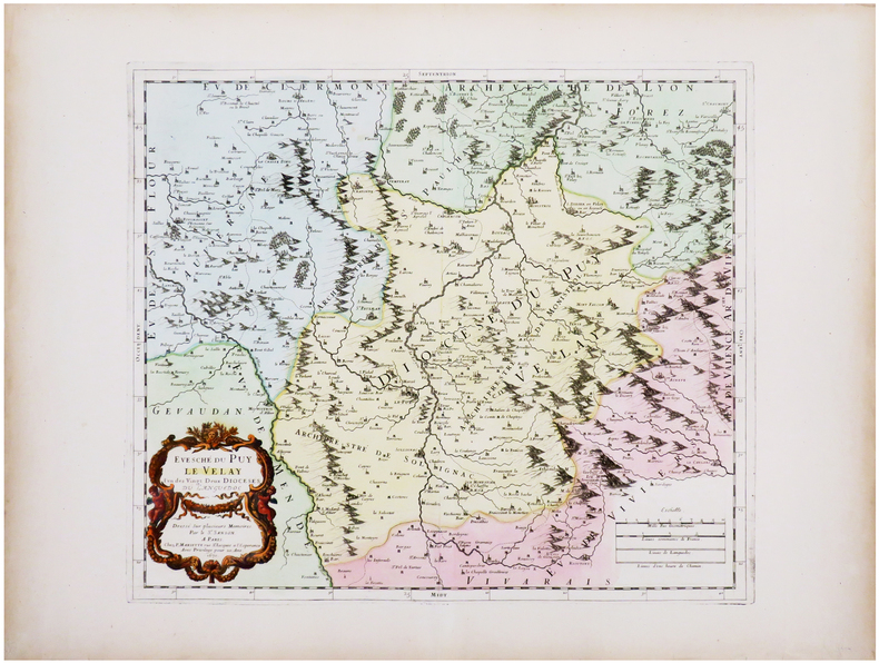
SANSON (Guillaume) & SANSON d'ABBEVILLE (Nicolas).
[LE PUY-en-VELAY] Évesché du Puy Le Velay l'un des vingt deux diocèses du Languedoc.
Paris, P. Mariette, 1670. 367 x 423 mm.
Bookseller reference : LBW-7226
|
|
|
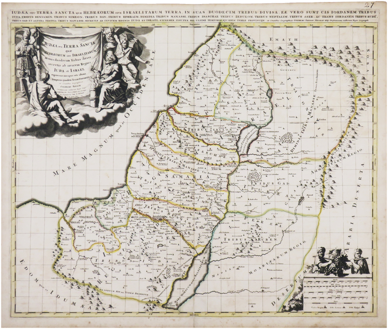
SANSON (Guillaume).
Judæa seu Terra Sancta quæ Hebræorum sive Israelitarum in suas duodecim tribus divisa.
Amsterdam, Pierre Schenk, [circa 1700]. 487 x 577 mm.
Bookseller reference : LBW-8050
|
|
|
SANSON d'ABBEVILLE (Nicolas) & COVENS (Jean) & MORTIER (Pierre).
Romani imperii qua occidens est, descriptio geographica.
Amsterdam, J. Covens et C. Mortier, [circa 1720]. 400 x 501 mm.
Bookseller reference : LBW-464
|
|
|
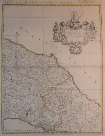
SANSON d'ABBEVILLE (Nicolas) & COVENS et MORTIER.
[TOSCANE/ETATS DE L'EGLISE] Estats de l'Eglise et de Toscane.
Amsterdam, Covens et Mortier, [circa 1710]. 580 x 445 mm.
Bookseller reference : LBW04176
|
|
|
SANSON d'ABBEVILLE (Nicolas) & JAILLOT (Alexis-Hubert).
[CATALOGNE] Principauté de Catalogne où sont compris les comtés de Roussillon et de Cerdagne divisés en leurs vigueries.
Paris, H. Jaillot, 1696. En deux feuilles jointes formant une carte de 565 x 868 mm.
Bookseller reference : LBW-6394

|
|
|
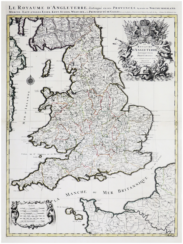
SANSON d'ABBEVILLE (Nicolas) & JAILLOT (Alexis-Hubert).
Le Royaume d'Angleterre distingué en ses provinces.
Paris, H. Jaillot, 1693. En deux feuilles jointes formant une carte de 785 x 584 mm.
Bookseller reference : LBW-6390
|
|
|
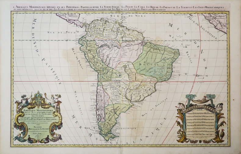
SANSON d'ABBEVILLE (Nicolas) & JAILLOT (Hubert).
Amérique méridionale divisée en ses principales parties où sont distingués les uns des autres les estats suivant qu'ils appartiennent présentement aux François, Castillans, Portugais, Hollandois, &c.
Paris, H. Jaillot, 1691. En deux feuilles jointes de 573 x 884 mm.
Bookseller reference : LBW-3673
|
|
|
SANSON d'ABBEVILLE (Nicolas) & SCHENK (Petrus).
[PAYS-BAS] Le cours de la rivière du Rhein depuis sa source jusques à son emboucheure où sont distingués toutes les estats et souverainetés.
Amsterdam, Pierre Schenk, [circa 1700]. 472 x 575 mm.
Bookseller reference : LBW0416f

|
|
|
SANSON d'ABBEVILLE (Nicolas) & TAVERNIER (Melchior).
[ROUTES des POSTES] Carte géographicque des postes qui traversent la France.
[Paris, Melchior Tavernier, 1632-1637]. 412 x 532 mm.
Bookseller reference : LBW-1373

|
|
|
SANSON d'ABBEVILLE (Nicolas).
[AFRIQUE MÉRIDIONALE] Basse Æthiopie qui comprend les royaume de Congo, coste, et pays des Cafres, empires du Monomotapa, et Monoemugi.
Paris, P. Mariette, 1655. 419 x 556 mm.
Bookseller reference : LBW-4533

|
|
|
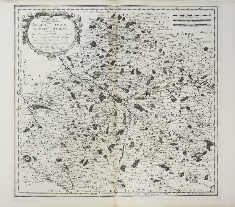
SANSON d'ABBEVILLE (Nicolas).
[AMIENS] Ambiani. Archid.conné d'Amiens, de l'évesché d'Amiens où sont les ball.ge et eslection d'Amiens.
Paris, P. Mariette, 1667. 394 x 411 mm.
Bookseller reference : LBW-3639
|
|
|
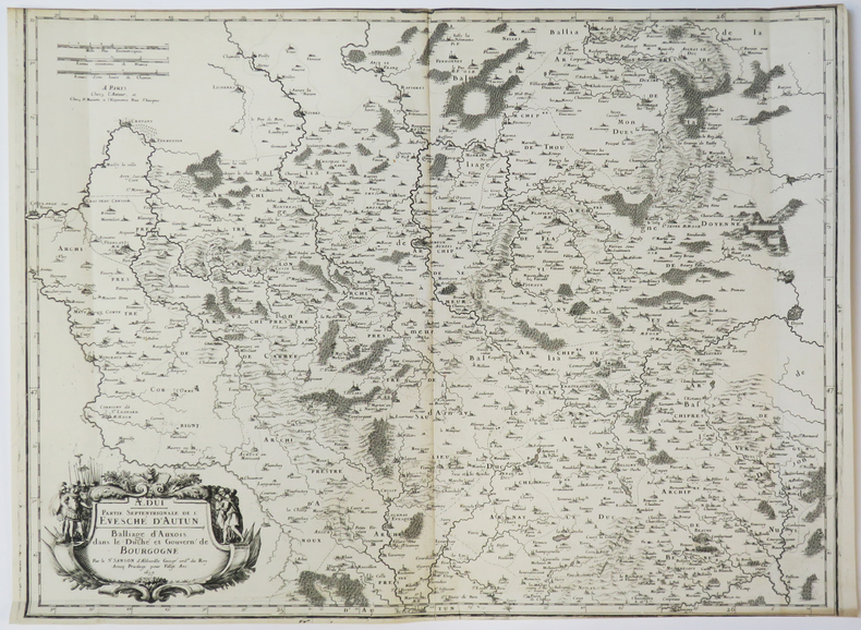
SANSON d'ABBEVILLE (Nicolas).
[AUXOIS] Ædui. Partie septentrionale de l'évesché d'Autun. Balliage d'Auxois dans le duché et gouvern. de Bourgogne.
Paris, chez l'auteur, 1659. 427 x 557 mm.
Bookseller reference : LBW-3641
|
|
|
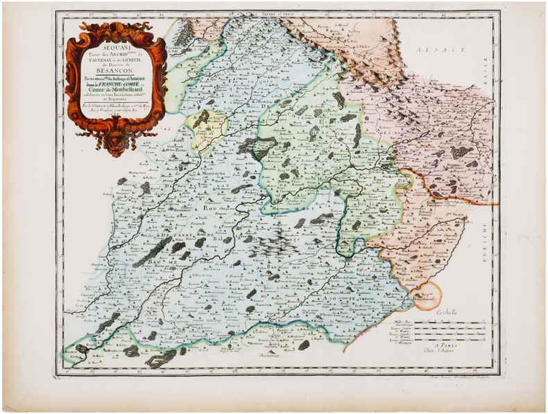
SANSON d'ABBEVILLE (Nicolas).
[BESANÇON/MONTBÉLIARD] Sequani. Partie des archid.connés de Favernay et de Luxeuil du diœcèse de Besançon. Partie orientale du balliage d'Amont dans la Franche Comté, et comté de Monbelliard.
Paris, chez l'auteur, 1679. 397 x 484 mm.
Bookseller reference : LBW-7225
|
|
|
SANSON d'ABBEVILLE (Nicolas).
[BLOIS & VENDÔME] Carnutes. Partie mérid.le de l'évesché de Chartres. Balliages de Blois et de Vendosme. Eslections de Chau-dun de Vendosme et de Blois.
Paris, P. Mariette, 1660. 411 x 564 mm.
Bookseller reference : LBW-3467

|
|
|
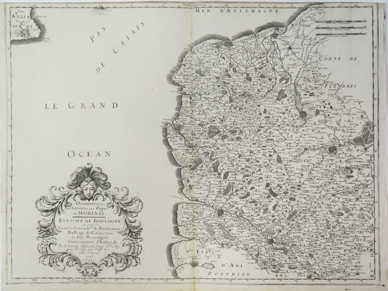
SANSON d'ABBEVILLE (Nicolas).
[BOULOGNE/MER] Oromansaci, et Gesoriacus Pagus in Morinis. Evesché de Boulogne où sont les comté et sénesch.ssée de Boulenois. Balliage de Calais dans le Pays Reconquis. Souveraineté d'Ardres, &c.
Paris, chez l'auteur, 1656. 415 x 550 mm.
Bookseller reference : LBW-3430
|
|
|
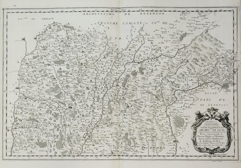
SANSON d'ABBEVILLE (Nicolas).
[BRESSE/BUGEY/VALROMEY] Insubres in Segusiani. Partie du diœcèse et archev.ché de Lyon. Partie septentrionale de Bresse, Bugey, et Valromey, divisée en leurs mandements. Le balliage de Gex.
Paris, P. Mariette, 1660. 354 x 555 mm.
Bookseller reference : LBW-3667
|
|
|
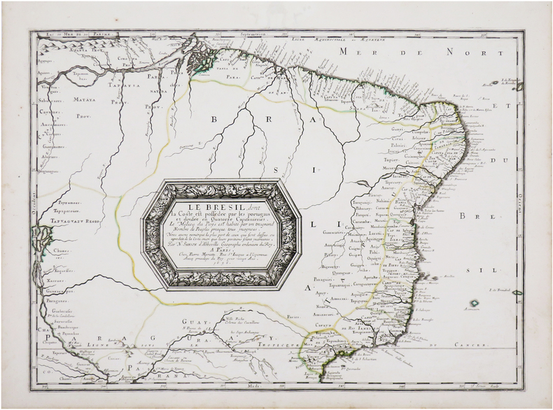
SANSON d'ABBEVILLE (Nicolas).
[BRÉSIL] Le Brésil, dont la coste est possédée par les portugais et divisée en quatorze capitanieries. Le milieu du pays est habité par un très grand nombre de peuples presque tous incogneus.
Paris, Pierre Mariette, 1656 [1658]. 394 x 542 mm.
Bookseller reference : LBW-7142
|
|
 Receive by email
 Download as PDF document
 RSS feed


