|
|
|
Seutter, Matthias
Lüneburg, eine alte ehemals Herzoglich, nunmehro Churfürstl. Hanoversche wohlberühmte Statt in Nidersaechsischen Crays. Teilkolorierter Kupferstich.
Augsburg, [ca. 1760]. 50 x 56,5 cm. Unter Passpartout. Gerahmt.
Bookseller reference : 86611

|
|
|
Seutter, Matthäus
Borussiae Regnum sub fortissimo Tutamine et justissimo Regimine Serenissimi ac Potentissimi Princips Friderici Wilhelmi. Altkolor. Kupferstich, mit Nebenkarte des Fürstentums Neuchatel, üppiger heraldischer Titelkartusche mit dem allegor. überhöhten Portr. Friedrich Wilhelms I., Meilenzeiger u. kleiner Windrose.
Augsburg, [ca. 1730]. 49,5 x 58 cm im Rahmen (57 x 66 cm). (Mit handschriftl. Pagina 22 (oben rechts) von alter Hand.
Bookseller reference : 76480

|
|
|
SEVIM TEKELI.
Map of Japan by Mahmud of Kashgar; The oldest map of Japan drawn by a Turk, Mahmud Kashgar.
Fine English Paperback. Pbo. 12mo. (17 x 11 cm). In English. 16 p., 1 map. Map of Japan by Mahmud of Kashgar; The oldest map of Japan drawn by a Turk, Mahmud Kashgar.
|
|
|
SEVIM TEKELI.
The oldest map of Japan drawn by a Turk Mahmud of Kashgar. The map of America by Pirî Reis.
Fine English Paperback. Pbo. Roy. 8vo. (24 x 17 cm). In English. 20 p., 1 map. The oldest map of Japan drawn by a Turk Mahmud of Kashgar. The map of America by Pirî Reis.
|
|
|
SEVIM TEKELI.
The oldest map of Japan drawn by a Turk Mahmud of Kashgar. The map of America by Pirî Reis.
Fine English Paperback. Pbo. Roy. 8vo. (24 x 17 cm). In English. 20 p., 1 map. The oldest map of Japan drawn by a Turk Mahmud of Kashgar. The map of America by Pirî Reis.
|
|
|
SEVRES
Carte au 1/20 000?me. Fin XIXe.
Une feuille. 64x46 cm.
|
|
|
Seyer, Rev. Samuel.
MEMOIRS HISTORICAL AND TOPOGRAPHICAL OF BRISTOL AND IT'S NEIGHBOURHOOD, From the Earliest Period Down to the Present Time. Two Volumes.
Two Volumes. pp. 535; 602, (8) + Engraved title + 35 plates. With engraved illustrations in the text. Illustrated with numerous full page engravings and lithographs of views, buildings, maps, drawings, etc. One plate in hand color. Marbled endpapers. Text and plates have some foxing. Some offsetting from plates. Top edges gold. Deckle edges. 4to. 290 mm. Half leather over marbled boards. Raised bands. Spines decorated and lettered in gold. Inked ownership of Miss Ann Willcox on top of preface pages and elsewhere. Bookplate of Redmond Conyngham in both volumes. Redmond Conygham (1781-1846) was born in Philadelphia. He inherited from his paternal grandfather an estate in the county Donegal, Ireland, yielding L2,000 a year, and subsequently spent some time in Ireland. During his stay abroad he became intimate with Curran, Grattan, and other prominent Irishmen, including his cousin, William Conyngham Plunket, afterward lord-chancellor of Ireland. On his return to the U.S. he settled in Luzerne County, Pennsylvania, and was active in state and local politics. He then removed to Lancaster County, where he devoted much of his leisure to antiquarian research. Issued as a limited edition, less than 500 copies were printed. A very good copy of this handsome and informative book. Scarce. **PRICE JUST REDUCED! LivRm
|
|
|
SEYIR, HIDRIGRAFI VE OSINIOGRAFI DAIRESI BASKANLIGI.
Seyir, Hidrografi ve Osinografi Dairesi Baskanligi seyir haritalari ve notik yayinlar katalogu.
Fair English Paperback. Pbo. Roy. 8vo. (23 x 16 cm). In Turkish. With folding plans. Navigational maps, nautical charts and publications catalogue of department of course, hydrography and oceanography of Naval Forces. Seyir, Hidrografi ve Osinografi Dairesi Baskanligi seyir haritalari ve notik yayinlar katalogu.
|
|
|
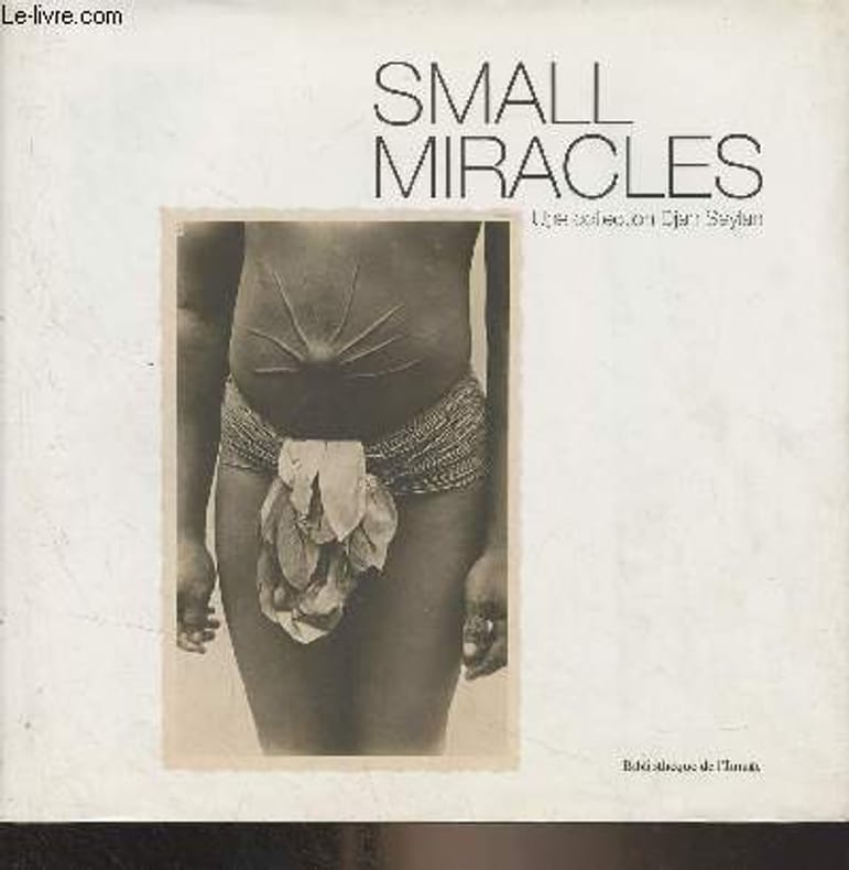
Seylan Djan
Small Miracles - Cartes postales exotiques 1895-1920
Bibliothèque de l'image. 2014. In-8. Relié. Bon état, Couv. convenable, Dos satisfaisant, Intérieur frais. 187 pages - nombreuses photos en noir et blanc et en couleurs hors texte. Jaquette légèrement passée et déchirée en coiffe de pied.. Avec Jaquette. . . Classification Dewey : 741.68-Illustrations des cartes postales
Bookseller reference : R300323394
|
|
|
Seymour William/Stirling David foreword/Watson WFN. maps W. F.
British Special Forces
London: Sidgwick & Jackson 1985. 1st printing. VG/VG dust jacket blind stamp on title page. xxvi 334 p. maps footnotes biblio index 8vo; Sidgwick & Jackson hardcover
Bookseller reference : 46135 ISBN : 0283988738 9780283988738

|
|
|
Seymour William; maps and illustrations by W F N Watson
Great Sieges of History
Brassey's UK 1991 1991. First Edition. Hardcover. Very Good Condition/No Dust Jacket. Navy cloth gilt lettering numerous maps 338pp. Covers clean and firm with lightly bumped lower corners binding sound pages clean no inscriptions. First ed. No dust-jacket. Quantity Available: 1. Shipped Weight: 1-2kg. Pictures of this item not already displayed here available upon request. Inventory No: 65014080274. This book is heavier than 1kg and may incur additional delivery charges on some delivery services to some locations. Brassey's (UK), 1991 hardcover
Bookseller reference : 65014080274

|
|
|
SEYMOUR WILLIAM & WATSON W. F. N. Maps
Yours to Reason Why: Decision in Battle
Book Club / Sidgwick &Jackson 1982. Super octavo hardcover VG in d/w VG; all our specials have minimal description to keep listing them viable. They are at least reading copies complete and in reasonable condition but usually secondhand; frequently they are superior examples. Ordering more than one book will reduce your overall postage costs. Book Club / Sidgwick &Jackson 1982 hardcover
Bookseller reference : 218203
|
|
|
Shane A. Thomas DipPubPol PhD MAPS
How to Write Health Sciences Papers Dissertations and Theses
Churchill Livingstone. Paperback. GOOD. Spine creases wear to binding and pages from reading. May contain limited notes underlining or highlighting that does affect the text. Possible ex library copy will have the markings and stickers associated from the library. Accessories such as CD codes toys may not be included. Churchill Livingstone paperback
Bookseller reference : 3198573235 ISBN : 0443062838 9780443062834

|
|
|
Shane A. Thomas DipPubPol PhD MAPS
How to Write Health Sciences Papers Dissertations and Theses
Churchill Livingstone 05/04/2000. Paperback. Used; Good. Includes Notes and/or Highlights WE SHIP WITHIN 24 HRS FROM LONDON UK 98% OF OUR ORDERS ARE RECEIVED WITHIN 7-10 DAYS. We believe you will be completely satisfied with our quick and reliable service. All orders are dispatched as swiftly as possible! Buy with confidence! Churchill Livingstone paperback
Bookseller reference : 3548684 ISBN : 0443062838 9780443062834
|
|
|
Shane A. Thomas DipPubPol PhD MAPS
How to Write Health Sciences Papers Dissertations and Theses 1e
2000-06-03. New. Ships with Tracking Number! INTERNATIONAL WORLDWIDE Shipping available. May be re-issue. Buy with confidence excellent customer service! unknown
Bookseller reference : 0443062838n ISBN : 0443062838 9780443062834

|
|
|
Shane A. Thomas DipPubPol PhD MAPS
How to Write Health Sciences Papers Dissertations and Theses
Churchill Livingstone 05/04/2000. Paperback. Used; Good. WE SHIP WITHIN 24 HRS FROM LONDON UK 98% OF OUR ORDERS ARE RECEIVED WITHIN 7-10 DAYS. We believe you will be completely satisfied with our quick and reliable service. All orders are dispatched as swiftly as possible! Buy with confidence! Churchill Livingstone paperback
Bookseller reference : mon0000846528 ISBN : 0443062838 9780443062834
|
|
|
Shane A. Thomas DipPubPol PhD MAPS
How to Write Health Sciences Papers Dissertations and Theses 1e
Churchill Livingstone 2000-06-20. 1. Paperback. Used:Good. Churchill Livingstone paperback
Bookseller reference : DADAX0443062838 ISBN : 0443062838 9780443062834
|
|
|
Shane A. Thomas DipPubPol PhD MAPS
How to Write Health Sciences Papers Dissertations and Theses
Churchill Livingstone 2000-06-06. Paperback. Good. Churchill Livingstone paperback
Bookseller reference : SONG0443062838 ISBN : 0443062838 9780443062834
|
|
|
Sharer, Robert; Sylvanus Morley
The Ancient Maya
A clean, unmarked book with a tight binding. Previous owner's name or label inside. 708 pages. Many b&w photos and illustrations.

|
|
|
SHAW (Thomas), M.D.
Voyages dans plusieurs provinces de la Barbarie et du Levant : contenant des observations géographiques, physiques, physiologiques et mêlées sur les royaumes d Alger et de Tunis, la Syrie, L Égypte et l Arabie Pétrée avec des cartes et des figures.
La HAYE ,Jean Neaulme, 1743, deux volumes in 4° (260x210mm) reliés plein veau marbré, dos orné à 5 nerfs, pièce de titre, tranches rouges ,(2 plats détachés),coiffes arasées, coins usés, papier bruni ,Épître à Frédéric roi de Prusse imprimé en rouge et noir, XLIV-414pp./IV-192 pp., à la suite extraits de plusieurs auteurs anciens et autres pièces ,178 pp. ,orné de 12 cartes dont 9 dépliantes et 21 planches dont 5 dépliantes, une planche de musique et un fragment de la célèbre carte de Peutinger , ex-libris de Charles Kettaneh Première édition en français,
Bookseller reference : PHO-1218
|
|
|
Shell.
Road Map of the Gulf. [Middle East], Hunting Surveys Ltd., 1970s.
Laminated folding map. Ca. 910 x 580 mm. Scale 1:1,500,000. Captions in English and Arabic. Road map of the Gulf region with 7 inset plans of Manama, Doha, Abu Dhabi, Kuwait, Dubai, Mutrah and Muscat. Apart from main and secondary roads and railways, the chart details larger and smaller towns, pipelines and oil fields. - Pierced near corners. Otherwise well preserved.
|
|
|
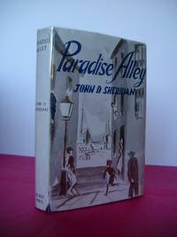
Sheridan John D.
PARADISE ALLEY A Novel
Dublin: The Talbot Press 1945. 273 pages. Original dust jacket bright without browning; a little rubbing and general wear lightly scuffed to head/tail of the spine and corners small chip to centre of front spine fold and several marginal tears repaired to the reverse with archival materials now protected in a clear removable archival sleeve. Hard-back binding very good. Contents clean and tight no inscriptions no foxing. A fine first edition copy in a very good jacket. Scarce first edition. First Edition. Hardback. Fine/Very Good. 8vo. The Talbot Press Hardcover
Bookseller reference : 023064
|
|
|
Sherman James E. and Barbara H. Maps by Don Percious
Ghost Towns of Arizona
Norman OK: University of Oklahoma Press 1969. 2nd printing 1970. GOOD only with top-to-bottom crease to rear board; head and heel of spine and corners of boards lightly bumped page edges dusty. Lacks jacket. ix 208 pp. illus. Hardcover. Good/No Jacket. 4to. University of Oklahoma Press Hardcover
Bookseller reference : 289666 ISBN : 0806108428 9780806108421
|
|
|
Sherman James E. & Barbara H. Maps by Jim Cooper
Ghost Towns and Mining Camps on New Mexico
Norman: University of Oklahoma 1975. First edition. Wraps. Very Good. 4to 270 pp. illus. Spine slightly creased wrappers sunned and a bit edgeworn with small spot on front date in ink on halftitle. University of Oklahoma paperback
Bookseller reference : 8036 ISBN : 0806111062 9780806111063

|
|
|
Sherman James E./Sherman Barbara H./Percious Don maps
Ghost Towns of Arizona
Norman: University of Oklahoma Press 1972. 4th paperback printing. Very Good. x 214 p. photos maps biblio index 4to paperback; University of Oklahoma Press paperback
Bookseller reference : 14535 ISBN : 0806108436 9780806108438

|
|
|
Sherman Paddy; John A. Hall maps
Cloud Walkers; Six Climbs on Major Canadian Peaks
Toronto: Macmillan of Canada. Very Good in Good dust jacket. 1965. First Edition. Hardcover. Price clipped DJ is chipped with light creasing 1 short tear bottom back cover. ; A tight solid book. Only light wear to book.; B&W Photographs; 8vo 8" - 9" tall; 161 pages; Third person accounts of ascents of Robson Logan Slesse Fairweather Waddington and Howson mountain peaks in the Canadian Rockies. . Macmillan of Canada hardcover
Bookseller reference : 14721
|
|
|
Sherrill, Captain C. O.
MILITARY MAP READING. Fourth Edition. Adopted by the War Department for use by the Organized Militia. Army Service Schools. U.S. Marine Corps.
63p. + Plus three folding maps. Text illustrated with maps, charts, drawings and diagrams. 8vo. Original full red cloth binding, very slightly soiled. Nice copy. First issued in 1909. WWI 5
|
|
|
Shuckford, Samuel (1693-1754); Creighton, James.
THE SACRED AND PROFANE HISTORY OF THE WORLD CONNECTED, FROM THE CREATION OF THE WORLD to the Dissolution of the Assyrian Empire at the Death of Sardanapalus, and to the Declensions of the Kingdoms of Judah and Israel under the Reigns of Ahaz and Pekah: Including the Dissertation on the Creation and Fall of Man. Revised, Corrected and Greatly Improved, by James Creighton. Four Volumes In Two. The First American from the Fifth London Edition.
Four volumes in two. Two folding maps and one single full page map (as called for in OCLC). Deckled edges. Foxed. Mildly XLib. XLib stamp of the A.R. Wentz Library Lutheran Theological Seminary Gettysburg, PA on top edges and verso of the dedication page. 8vo. 235 mm. S&S/AI 17982. First American from the fifth London edition. Original boards and label binding, broken. Best to consider as virtually disbound. Text very good. PAIMP 24
|
|
|
Sibree, Jas. Jr. F.R.G.S.
Colour Map of Madagascar - Unexplored Territories Indicated: Circa 1902
Outside dimensions 14.5" x 10.5". Circa 1902. Centerfold. Light wear. Please see our photo for details. Book

|
|
|
SICKLER Friedrich Charles Louis
Veduta di Roma ad Monte Mario
Schematica veduta a contorno di Roma da Monte Mario, pubblicata nel 1816, e ristampata più volte assieme al testo esplicativo, che, priva di finalità artistiche, era indirizzata, come avverte l'autore, "à l'usage des voyageurs". Si tratta del "Pantogramma des Environs de Rome destiné à faire suite au Plan Topographique due même pays" di F. Ch. L. Sickler, Membre de l'Academie des Antiquités à Rome". Nelle otto fitte righe presenti nella parte superiore dell'incisione, oblunga e in tre rami, sono riportati i nomi degli antichi popoli del Lazio, delle località e paesi dei dintorni, antichi e moderni, i monumenti più importanti, le chiese, molti palazzi e le strade principali del centro cittadino.Acquaforte, impressa su carta vergata coeva, più volte ripiegata, leggere ossidazioni per il resto in ottimo stato di conservazione. Schematic view of Rome from Monte Mario, published in 1816, that was realized "à l'usage des voyageurs". Taken from the "Pantogramma des Environs de Rome destiné à faire suite au Plan Topographique due même pays" by F. Ch. L. Sickler, Membre de l'Academie des Antiquités à Rome ".In the eight dense lines in the upper part of the engraving are listed the names of the ancient peoples of Lazio, the localities and villages of the surroundings, ancient and modern, the most important monuments, churches, many palaces and streets of the city center.Etching, printed on contemporary laid paper and folded, some foxing otherwise very good. Frutaz p. 12; Roma Veduta pp. 88-89; Arrigoni Bertarelli n. 208.

|
|
|
SIEGFRIED (André)
La Suisse, démocratie-témoin. Etude. Edition revue et augmentée. Cartes.
Neuchâtel, éd. de la Baconnière 1956. Bel exemplaire relié, reliure soignée demi-parchemin, dos avec titres, in-8, 252 pages avec préface, introduction, conclusion, cartes, index des cartes, table.
Bookseller reference : AUB-7162
|
|
|
Siegfried Hermann:
Topographischer Atlas der Schweiz im Maßstab der Original-Aufnahmen nach dem Bundesgesetze von 18. Dezember 1868 vom eidgenössischen Stabsbüreau veröffentlicht (351 cartes).
351 cartes au format (sauf exception) d'environ 40 x 30 cm. Feuillets de titre et de présentations avec déchirures, certaines cartes en état moyen (rousseurs, déchirures, parfois avec manques), la plus grande partie néanmoins dans un état tout à fait satisfaisant (voir images).
Bookseller reference : 22007

|
|
|
SIEGFRIED, Oberst (Hermann).
Zeichenerklaerung zur Topographischen Atlas der Schweiz. Atlas topographique de la Suisse. Cartes dites “Siegfried” 25: 000, 1 à 548, dont il manque 4 cartes, la 119 - 476bis1 - 479 et 484, 39 cartes sont en deux ou trois feuilles, il y a une feuille de légendes et explications des signes et une de la répartition des régions, l’ensemble comprend 599 feuilles.
Bern, Eidg. Stadtsbureau 1922-1928, 530x425mm, L’ensemble des cartes sont réparties en 7 cartables avec fermoirs en tissus, toutes les cartes sont en très bel état.
Bookseller reference : 111599

|
|
|
Siegner, Otto and Heffe, Jacques
La Suisse
No marks or inscriptions. No creasing to covers or to spine. A very clean very tight copy with bright unmarked boards and no bumping to corners. Dust jacket not price clipped with chips, creases and tears to edges and a little colour loss to front. 239pp. Well over 200 full-size photographic plates, mainly black & white plus a few colour. Seven introductory pages of text in French.

|
|
|
Sigmund William F./Hoover Jr. Gene maps
Europe Under X-Ray
NY: Blue Ribbon Books 1940. 1st edition. Good. 24 p. maps clear red 'x-ray' overlays 4to oblong spiral bound; Blue Ribbon Books paperback
Bookseller reference : 30363
|
|
|
SIGNED & Inscribed by Author Andy Griffin. Illustrated in b/w with Photos & Maps Etc. with Preface by Author
Gypsy Jaunts: Good Times Live ForeverSpecial Advance Issue - Set No. 1. Free Fun and Adventure.in Southern California for Families Groups Visitors Teenagers-Senior Citizens The fun and adventure experiences featured in "Gypsy Jaunts" are
Gypsy Jaunts. Reseda CA Andrew M. Griffin 1964 SOFTCOVER 1964 1st Edition NF/GOOD AS-IS SOFTCOVER Pages are bound into three ring binder. White Binder with Gold Gilt has Slight creases is lightly soiled & has edge wear. Interior is clean and all the pages are free of tears.Special Advance Issue - Set No. 1. 5 1/2 in X 8 3/4 . .The fun and adventure experiences featured in "Gypsy Jaunts" are with a few exceptions absolutely free of any costs except the cost of gasoline for your car Includes Beale�s Cut The Dump Steckel Park Gaviota Beach Lytle Creek Canyon Kern County Pioneer Village UCLA Northwest of Idyllwild Port of Long Beach Santa Barbara Proctor & Gamble Factory Tour 3 Rings Horse Ranch Ramona Land Tucker Bird. Signed by Author. First Edition. Soft Cover. Gypsy Jaunts., Reseda, CA Andrew M. Griffin paperback
Bookseller reference : 26130
|
|
|
SILIOTTI Alberto
EGYPTE, TERRE DES PHARAONS
PARIS, Librairie Gründ, 1994In folio, cartonnage bleu, titre frappé or au dos de l'ouvrage, sous jaquette pelliculée illustrée en couleurs du célèbre masque funéraire en or de Toutankhamon, titre imprimé au dosTraduction française de Marie-Paule DUVERNEL'ouvrage est illustré de superbes planches photographiques en couleurs dans et en pleine page et in plano de Luca ROSSI. Les cartes et dessins en noir dans et hors le texte sont de Monica FALCONE et Cristina FRANCO,In fine, un glossaire illustré, une table des provinces de l'Egypte ancienne, une bibliographie et un indexOuvrage d'une grande qualité, superbe état de fraîcheur, proche du neuf
Bookseller reference : 2050
|
|
|
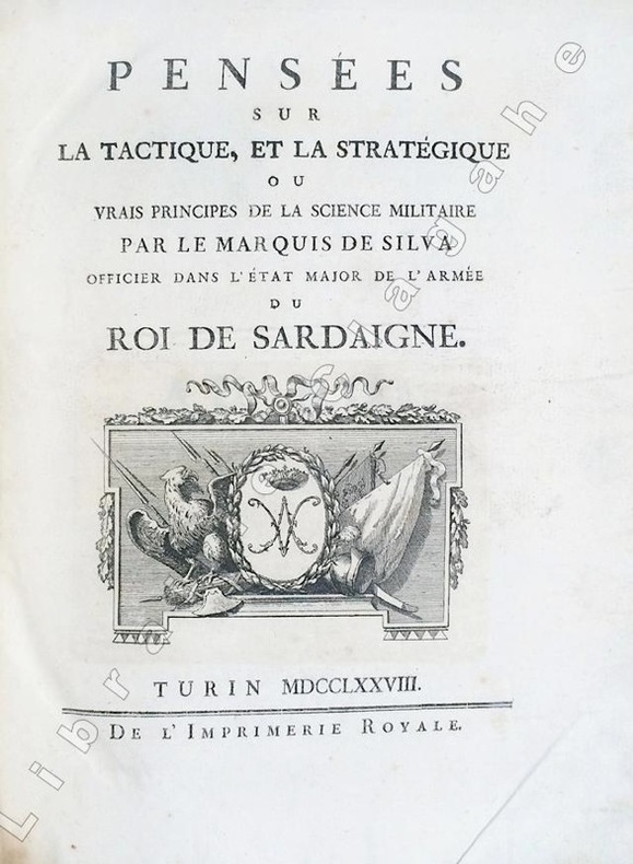
Silva, Marquis de :
Pensées sur la tactique et la stratégie ou vrais principes de la science militaire.
Turin, Imprimerie Royale, 1778 ; in-4 ; demi-veau glacé havane, dos à faux-nerfs dorés et palettes décoratives, pièce de titre vert-pistache, tranches mouchetées de bleu (reliure de l'époque) ; (14), 359, (1 bl.) ; (4), 55, (1) pp. et 30 planches gravées dépliantes.SUIVI DE : "CONSIDERATIONS SUR LA GUERRE DE 1769 ENTRE LES RUSSES ET LES TURCS. Nouvelle édition corrigée et augmentée de plusieurs notes historiques."
Bookseller reference : 6494
|
|
|
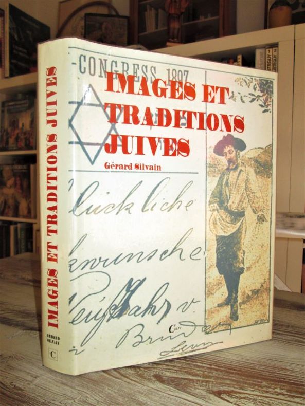
SILVAIN (Gérard).
Images et traditions juives. Un millier de cartes postales, 1897-1917, pour servir à l'histoire de la Diaspora.
P., Celiv, 1997. In-4 relié (33 x 24 cm), jaquette imprimée, 478 pages, préface d'Alain Poher, très nombreuses illustrations en noir et en couleurs. Reliure pleine toile bleue de l'éditeur, jaquette illustrée en couleurs. Les Juifs à travers la carte postale. « L'auteur possède quelques milliers de cartes postales juives tant sephardim (du pourtour méditerranéen) qu'ashkenazim (originaires d'Europe centrale) constituant autant de témoignages ethnographiques inédits. L'ouvrage qu'il présente donne une image de la Diaspora à partir des cartes postales publiées en vingt années, de 1897 à 1917. » (Henri Raczymow).-2580g.C. - Excellent état.
Bookseller reference : 27081
|
|
|
SILVAIN Gérard
Deux destins en diaspora, 1897-1947 - 50 ans de mémoires juives à travers un millier de cartes postales
1984, Albin Michel, in-4 pleine toile marron de 239+239 pages, jaquette illustrée, plus de 1000 illustrations et documents, préface de Pierre Bourget. Moi, Myriam Attias, juive sépharade, moi Yosef Lewski, juif ashkénaze. | Etat : Bon état général (Ref.: G3809)
Bookseller reference : 33268
|
|
|
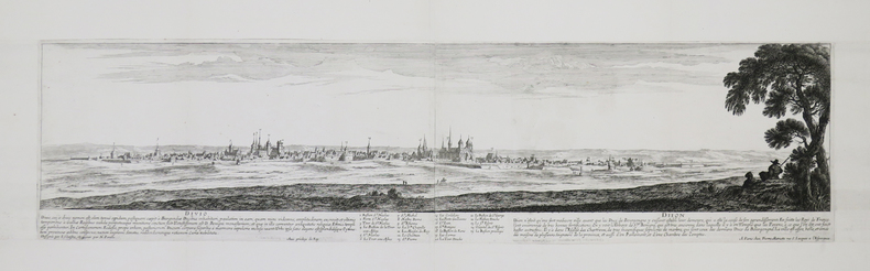
SILVESTRE (Israël).
[DIJON] Divio – Dijon. Dessignée par I. Silvestre, et gravée par N. Perelle. Avec privilège du roy. A Paris chez Pierre Mariette rue S. Jacques à l’Espérance.
[circa 1650]. En deux feuilles jointes de 200 x 795 mm.
Bookseller reference : LBW-4403
|
|
|
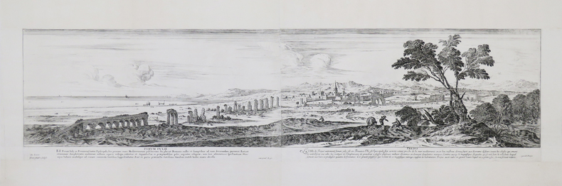
SILVESTRE (Israël).
[FRÉJUS] Forum Iulii – Frejus. De Lincler. Israel Silvestre sculpsit. Cum privil. Regis. excudit Parisiis.
[circa 1650]. En deux feuilles jointes de 215 x 820 mm.
Bookseller reference : LBW-4405
|
|
|
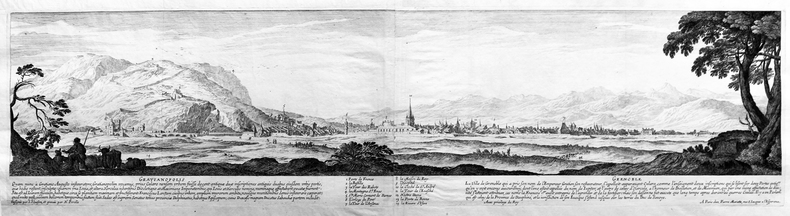
SILVESTRE (Israël).
[GRENOBLE] Gratianopolis – Grenoble. Dessignée par I. Silvestre, et gravée par N. Perelle. Avec privilège du roy. A Paris chez Pierre Mariette, rue S. Jacques à l’Espérance.
[circa 1650]. En deux feuilles jointes de 200 x 780 mm.
Bookseller reference : LBW-4398
|
|
|
SILVESTRE (Israël).
[METZ] Profil de la ville de Metz en Lorraine veue du costé de la porte Mazel.
Paris, Israel Silvestre, 1667. En deux feuilles jointes de 400 x 1286 mm.
Bookseller reference : LBW-4500

|
|
|
SILVESTRE (Israël).
[ROME] Chapelle bastie à Ste Marie Major à Rome par Paul Vme très-superbement comme il se voit par l’extérieur. Goyran sculp.
[circa 1650]. 335 x 450 mm.
Bookseller reference : LBW-4407

|
|
|
SILVESTRE Israel (Nancy, 1621 - Parigi, 1691).
(Panorama di Roma)
Acquaforte, 1645/50 circa, firmata in lastra in basso a destra..Inusuale veduta panoramica della città, con vista su vari monumenti, descritti in basso in un legenda di 9 punti, riportata in basso in italiano e francese e che comprende: 1. Vestigij del Tempio della Pace . 2. Chiesa di S.ta Francesca Romana . 3. Vigna Fanesia . 4. Vestigij del Palazzo Maggiore. 5. Vestigij della Casa di Cicerone. 6. St. Maria liberatrice . 7. St. Pietro Montorio. 8. Frontespitio dell'Acqua Paula. 9. Colonne restate del Tempio di Giove Statore. La Basilica, in primo piano, è disegnata con grande dettaglio, come pure il panorama della città, dove sono riconoscibili numerose opere architettoniche. Come per il panorama generale di Roma, anche questa veduta generale venne probabilmente incisa "da un disegno eseguito ad vivum da L. de Lincher, un disegnatore francese poco noto che fu attivo in quegli anni a Roma e fornì i sui disegni a diversi incisori fra i quali anche il conterraneo Francois Collignon" (cfr. Barbara Jatta in "Roma Veduta" p. 164),Il Silvestre, incisore e disegnatore, nasce a Nancy nel 1621. Tra il 1638 e il 1641 viaggiò in Italia; si hanno notizie della sua presenza nella Penisola ancora nel 1643 e nel 1653. Il suo stile fu, all’inizio, piuttosto sciolto, ma dal 1643 in poi divenne più raffinato e delicato, acquisendo accuratezza e precisione senza essere asciutto, risultando a volte simile a quello di Jacques Callot o di Stefano della Bella, con i quali ebbe rapporti di amicizia. Accanto alle testimonianze per la Roma antica mostrò ben presto un grandissimo interesse per la città "moderna", divenendo uno dei precursori del vedutismo - non solo nel campo incisorio - anticipando artisti come Lievin Cruyl e Gaspar van Wittel. Bellissima prova, con ampli margini, pieghe verticali dovute alla conservazione - più volte ripiegata e conservata il album - in ottimo stato di conservazione. Rara. Etching, circa 1645/50, signed on the lower right-hand plate. Unusual panoramic view of the city, with a view of various monuments, described in a 9-point legend at the bottom in Italian and French, including: 1. Vestigij del Tempio della Pace . 2. Chiesa di S.ta Francesca Romana . 3. Vigna Fanesia . 4. Vestigij del Palazzo Maggiore. 5. Vestigij della Casa di Cicerone. 6. St. Maria liberatrice . 7. St. Pietro Montorio. 8. Frontespitio dell'Acqua Paula. 9. Colonne restate del Tempio di Giove Statore. The Basilica, in the foreground, is drawn in great detail, as is the panorama of the city, where numerous architectural works are recognisable. As with the general view of Rome, this panorama was probably engraved "from a drawing made ad vivum by L. de Lincher, a little-known French draughtsman who was active in Rome in those years and supplied his drawings to various engravers, including his fellow countryman Francois Collignon" (cf. Barbara Jatta in "Roma Veduta" p. 164). Silvestre, engraver and draughtsman, was born in Nancy in 1621. Between 1638 and 1641 he travelled in Italy; there are records of his presence in the Peninsula again in 1643 and 1653. His style was rather loose at first, but from 1643 onwards it became more refined and delicate, acquiring accuracy and precision without being dry, sometimes resembling that of Jacques Callot or Stefano della Bella, with whom he was friends. Alongside the evidence for ancient Rome, he soon showed great interest in the "modern" city, becoming one of the forerunners of vedutism - not only in the field of engraving - anticipating artists such as Lievin Cruyl and Gaspar van Wittel. Beautiful proof, with wide margins, vertical folds due to storage - folded several times and stored in the album - in excellent condition. Rare.

|
|
|
SILVESTRE Israel (Nancy, 1621 - Parigi, 1691).
Panorama di Roma da Monte Mario
Acquaforte, 1642, firmata in lastra in basso.Bellissima prova, impressa su carta vergata coeva, con ampi margini, in perfetto stato di conservazione.Inusuale veduta panoramica della città, presa dalle pendici di Monte Mario. La Basilica, in primo piano, è disegnata con grande dettaglio, come pure il panorama della città, dove sono riconoscibili numerose opere architettoniche. "L'incisione è la prima grande veduta di Roma realizzata da Israel Silvestre pochi anni dopo il suo arrivo in città. Questa è ripresa dalle pendici di Monte Mario e il panorama spazia dalla Porta del Popolo al complesso del Vaticano. Il formato oblungo e la scelta del punto di vista verrà largamente ripreso dagli artisti successivi. La veduta venne incisa da un disegno eseguito ad vivum da L. de Lincher, un disegnatore francese poco noto che fu attivo in quegli anni a Roma e fornì i sui disegni a diversi incisori fra i quali anche il conterraneo Francois Collignon" (cfr. Barbara Jatta in "Roma Veduta" p. 164),Il Silvestre, incisore e disegnatore, nasce a Nancy nel 1621. Tra il 1638 e il 1641 viaggiò in Italia; si hanno notizie della sua presenza nella Penisola ancora nel 1643 e nel 1653. Il suo stile fu, all’inizio, piuttosto sciolto, ma dal 1643 in poi divenne più raffinato e delicato, acquisendo accuratezza e precisione senza essere asciutto, risultando a volte simile a quello di Jacques Callot o di Stefano della Bella, con i quali ebbe rapporti di amicizia. Accanto alle testimonianze per la Roma antica mostrò ben presto un grandissimo interesse per la città "moderna", divenendo uno dei precursori del vedutismo - non solo nel campo incisorio - anticipando artisti come Lievin Cruyl e Gaspar van Wittel.Primo, in ordine cronologico, dei quattro panorami dedicati dall’artista francese alla città. Molto rara. Bibliografia Le Blanc III, p. 508, 224; Roma Veduta, pp. 164-165, n. 24; Faucheaux, Catalogue raisonné de l’oeuvre d’Israel Silvestre, 28 II/II. Etching, 1642, signed on lower plate.Beautiful work, printed on contemporary laid paper, wide margins, in very good condition. First, in chronological order, of the four panoramas dedicated by the French artist to the city. The engraving is the first large view of Rome made by Israel Silvestre a few years after his arrival in the city. This is taken from the slopes of Monte Mario and the panorama ranges from the Porta del Popolo to the Vatican complex. The oblong format and the choice of the viewpoint will be largely taken up by the artists who followed. The view was engraved from a drawing made ad vivum by L. de Lincher, a little-known French artist who was active in Rome in those years and supplied his drawings to various engravers, including his fellow countryman Francois Collignon (cf. Barbara Jatta in "Roma Veduta" p. 164) Silvestre, engraver and draftsman, was born in Nancy in 1621. Between 1638 and 1641 he travelled in Italy; we have news of his presence in the Peninsula still in 1643 and 1653. His style was, at the beginning, rather loose, but from 1643 onwards he became more refined and delicate, acquiring accuracy and precision without being dry, sometimes similar to that of Jacques Callot or Stefano della Bella, with whom he had friendly relations. Alongside the evidence for ancient Rome, he soon showed great interest in the 'modern' city, becoming one of the precursors of vedutism - not only in the field of engraving - anticipating artists such as Lievin Vruyl and Gaspar van Wittel. Literature Le Blanc III, p. 508, 224; Roma Veduta, pp. 164-165, n. 24; Faucheaux, Catalogue raisonné de l’oeuvre d’Israel Silvestre, 28 II/II.

|
|
|
SILVESTRE Israel (Nancy, 1621 - Parigi, 1691).
Veduta del Campo Vaccino, e duna parte delle Città, di Roma….
Acquaforte, 1652 circa, priva di firma in lastra dove troviamo la sola indicazione del privilegio. Bellissima prova, impressa su carta vergata coeva, con margini, in perfetto stato di conservazione. Veduta panoramica di Roma raffigurante presa dagli Orti Farnesiani, con il Foro Romano in primo piano. LO stemma araldico di Luigi XIV, con le armi di Francia e Navarra, è inciso al centro con la scritta Dédié au Roy. “L’impianto di questa veduta di Campo Vaccino, dedicata a Luigi XIV, che spazia dal Campidoglio alla Basilica di Massenzio, appartiene alla seconda fase della sua produzione, contraddistinta dall’estrema precisione nella rappresentazione degli edifici. È probabile che l’artista abbia scelto come punto di vista gli Horti Farnesiani sul Palatino che gli permettevano una visione dall’alto della città. Oltre alla raffigurazione dei monumenti antichi, la veduta è caratterizzata, seppure in secondo piano, dalla presenza di numerose architetture moderne della zona nord-orientale di Roma, tra le quali la chiesa di S. Maria di Loreto, Villa Medici, il Quirinale e il palazzo del cardinale Mazzarino alle Quattro Fontane” (cfr. Barbara Jatta in "Roma Veduta" p. 167). Il Silvestre, incisore e disegnatore, nasce a Nancy nel 1621. Tra il 1638 e il 1641 viaggiò in Italia; si hanno notizie della sua presenza nella Penisola ancora nel 1643 e nel 1653. Il suo stile fu, all’inizio, piuttosto sciolto, ma dal 1643 in poi divenne più raffinato e delicato, acquisendo accuratezza e precisione senza essere asciutto, risultando a volte simile a quello di Jacques Callot o di Stefano della Bella, con i quali ebbe rapporti di amicizia. Accanto alle testimonianze per la Roma antica mostrò ben presto un grandissimo interesse per la città "moderna", divenendo uno dei precursori del vedutismo - non solo nel campo incisorio - anticipando artisti come Lievin Cruyl e Gaspar van Wittel. Bibliografia Le Blanc III, p. 508, 228; Roma Veduta (2000), p. 167, n. 26; Faucheaux, Catalogue raisonné de l’oeuvre d’Israel Silvestre, 32.1; C. Marigliani, Le Piante di Roma delle collezioni private, tav. 122 Etching, about 1652, without signature on the plate where we find only the indication of the privilege. Beautiful proof, printed on contemporary laid paper, later hand colour, with margins, in perfect condition. Panoramic view of Rome taken from the Orti Farnesiani, with the Roman Forum in the foreground. The heraldic coat of arms of Louis XIV, with the arms of France and Navarre, is engraved in the center with the inscription Dédié au Roy. The layout of this view of Campo Vaccino, dedicated to Louis XIV, ranging from the Capitol to the Basilica of Maxentius, belongs to the second phase of his production, marked by extreme precision in the representation of the buildings. It is likely that the artist chose as a point of view the Horti Farnesiani on the Palatine, which allowed him a view of the city from above. In addition to the depiction of ancient monuments, the view is characterized, albeit in the background, by the presence of numerous modern buildings in the north-eastern area of Rome, including the church of S. Maria di Loreto, Villa Medici, the Quirinale and the palace of Cardinal Mazzarino at the Quattro Fontane (see Barbara Jatta in "Roma Veduta" p. 167). Silvestre, engraver and draftsman, was born in Nancy in 1621. Between 1638 and 1641 he traveled in Italy; we have news of his presence in the Peninsula again in 1643 and 1653. His style was, at the beginning, rather loose, but from 1643 onwards became more refined and delicate, acquiring accuracy and precision without being dry, resulting sometimes similar to that of Jacques Callot or Stefano della Bella, with whom he had relationships of friendship. Alongside the evidence for ancient Rome soon showed a great interest in the city "modern", becoming one of the precursors of vedutismo - not only in the field of engraving - anticipating artists such as Lievin Cruyl and Gaspar van Wittel. Literature Le Blanc III, p. 508, 228; Roma Veduta, p. 167, n. 26; Faucheaux, Catalogue raisonné de l'oeuvre d'Israel Silvestre, 32.1; C. Marigliani, "Le Piante di Roma delle collezioni private", n. 122.

|
|
|
SILVESTRE Israel (Nancy, 1621 - Parigi, 1691).
Vedute della Chiesa di S.to Pietro in Vaticano, et del Palazzo Papale, ed altri luoghi, disegnate in Roma fuori della porta
Acquaforte, 1652, firmata e datata in lastra in basso a sinistra Israel SIlvestre delineavit et sculpt. l'anne 1652 in Parigi. Bellissima prova, impressa su carta vergata coeva, con ampi margini, in perfetto stato di conservazione. Inusuale veduta panoramica della città, presa dalle pendici colle Vaticano - fuori da Porta Cavalleggeri come indicato nel titolo - con un magnifico e accurato dettaglio della Basilica Vaticana prima del colonnato del Bernini (1665). In alto al centro, in un cartiglio con lo stemma araldico di Louis Hesselin troviamo la dedica di Jean Vivot: Illustrissimo Nobillissimoque Domino. D. Hesselin Regi il Secretioribus Consilijs, Palatij, et Camerae denariorum Magistro Observantissimus Seruus J. Viuot Dicat. È probabile che Vivot, un comune gentiluomo della camera del Re, nominato nel 1670 custode dell'antiquariato, abbia commissionato al Silvestre questa veduta per dedicarla a Louis Hesselin, Seigneur de Condé aristocratico francese, funzionario del governo, mecenate e collezionista. Il Silvestre, incisore e disegnatore, nasce a Nancy nel 1621. Tra il 1638 e il 1641 viaggiò in Italia; si hanno notizie della sua presenza nella Penisola ancora nel 1643 e nel 1653. Il suo stile fu, all’inizio, piuttosto sciolto, ma dal 1643 in poi divenne più raffinato e delicato, acquisendo accuratezza e precisione senza essere asciutto, risultando a volte simile a quello di Jacques Callot o di Stefano della Bella, con i quali ebbe rapporti di amicizia. Accanto alle testimonianze per la Roma antica mostrò ben presto un grandissimo interesse per la città "moderna", divenendo uno dei precursori del vedutismo - non solo nel campo incisorio - anticipando artisti come Lievin Cruyl e Gaspar van Wittel. Bibliografia L. E. Faucheux, Catalogue raisonné de toutes les estampes qui forment l'oeuvre d'Israel Silvestre: précédé d'une notice sur sa vie (1857), n. 31.1; F. Baré, Israël Silvestre et sa famille, suivi du catalogue de son oeuvre (1885), n. 768. Etching, 1652, signed and dated on the plate at lower left Israel SIlvestre delineavit et sculpt. l'anne 1652 in Parigi. Beautiful proof, printed on contemporary laid paper, with wide margins, in perfect condition. Unusual panoramic view of the city, taken from the slopes of the Vatican hill - outside Porta Cavallegeri as indicated in the title - with a magnificent and accurate detail of the Vatican Basilica before Bernini's colonnade (1665). In the upper center, in a cartouche with the heraldic coat of arms of Louis Hesselin we find the dedication of Jean Vivot: Illustrissimo Nobillissimoque Domino. D. Hesselin Regi the Secretioribus Consilijs, Palatij, et Camerae denariorum Magistro Observantissimus Seruus J. Viuot Dicat. It is likely that Vivot, a common gentleman of the King's chamber, appointed in 1670 as keeper of antiques, commissioned Silvestre this view to dedicate it to Louis Hesselin, Seigneur de Condé French aristocrat, government official, patron and collector. Silvestre, engraver and draftsman, was born in Nancy in 1621. Between 1638 and 1641 he traveled in Italy; we have news of his presence in the Peninsula again in 1643 and 1653. His style was, at the beginning, rather loose, but from 1643 onwards became more refined and delicate, acquiring accuracy and precision without being dry, resulting sometimes similar to that of Jacques Callot or Stefano della Bella, with whom he had relationships of friendship. Alongside the evidence for ancient Rome soon showed a great interest in the city "modern", becoming one of the precursors of vedutismo - not only in the field of engraving - anticipating artists such as Lievin Cruyl and Gaspar van Wittel. Literature L. E. Faucheux, Catalogue raisonné de toutes les estampes qui forment l'oeuvre d'Israel Silvestre: précédé d'une notice sur sa vie (1857), n. 31.1; F. Baré, Israël Silvestre et sa famille, suivi du catalogue de son oeuvre (1885), n. 768.

|
|
|
SILVESTRE Israel (Nancy, 1621 - Parigi, 1691).
Vue de Rome et du derrière de l'Eglise St Pierre prise sur les hauteurs du mont Vatican hors la ville
Acquaforte, 1646 circa, firmata in lastra in basso a sinistra. Bellissima prova, impressa su carta vergata coeva, con ampi margini, in perfetto stato di conservazione. Inusuale veduta panoramica della città, presa dal colle Vaticano. La Basilica, in primo piano, è disegnata con grande dettaglio, come pure il panorama della città, dove sono riconoscibili numerose opere architettoniche. “È insolita la scelta del punto di vista di questa veduta romano, presa dal colle Vaticano, dietro la Basilica di San Pietro. Anche in quest’opera, sempre molto particolareggiata secondo lo stile tipico dell’artista, è forte l’influsso delle incisioni di Callot, sia nel linguaggio che nella costruzione della veduta, come ci conferma la quinta in primo piano con le mura vaticane"(cfr. Barbara Jatta in "Roma Veduta" p. 168). Il Silvestre, incisore e disegnatore, nasce a Nancy nel 1621. Tra il 1638 e il 1641 viaggiò in Italia; si hanno notizie della sua presenza nella Penisola ancora nel 1643 e nel 1653. Il suo stile fu, all’inizio, piuttosto sciolto, ma dal 1643 in poi divenne più raffinato e delicato, acquisendo accuratezza e precisione senza essere asciutto, risultando a volte simile a quello di Jacques Callot o di Stefano della Bella, con i quali ebbe rapporti di amicizia. Accanto alle testimonianze per la Roma antica mostrò ben presto un grandissimo interesse per la città "moderna", divenendo uno dei precursori del vedutismo - non solo nel campo incisorio - anticipando artisti come Lievin Cruyl e Gaspar van Wittel. Bibliografia Le Blanc III, p. 508, 225; Roma Veduta, pp. 168-169, n. 27; L. E. Faucheux, Catalogue raisonné de toutes les estampes qui forment l'oeuvre d'Israel Silvestre: précédé d'une notice sur sa vie (1857), n. 29.1; F. Baré, Israël Silvestre et sa famille, suivi du catalogue de son oeuvre (1885), n. 766. Etching, circa 1646, signed in plate at lower left. Beautiful proof, printed on contemporary laid paper, with wide margins, in perfect condition. Unusual panoramic view of the city, taken from the Vatican Hill. The Basilica, in the foreground, is drawn with great detail, as well as the panorama of the city, where many architectural works are recognizable. The choice of the point of view of this Roman view, taken from the Vatican Hill, behind St. Peter's Basilica, is unusual. Also in this work, always very detailed according to the typical style of the artist, the influence of Callot's engravings is strong, both in the language and in the construction of the view, as confirmed by the foreground with the Vatican walls (see Barbara Jatta in "Roma Veduta" p. 168). Silvestre, engraver and draftsman, was born in Nancy in 1621. Between 1638 and 1641 he traveled in Italy; we have news of his presence in the Peninsula again in 1643 and 1653. His style was, at the beginning, rather loose, but from 1643 onwards became more refined and delicate, acquiring accuracy and precision without being dry, resulting sometimes similar to that of Jacques Callot or Stefano della Bella, with whom he had relationships of friendship. Alongside the evidence for ancient Rome soon showed a great interest in the city "modern", becoming one of the precursors of vedutismo - not only in the field of engraving - anticipating artists such as Lievin Cruyl and Gaspar van Wittel. Literature Le Blanc III, p. 508, 225; Roma Veduta, pp. 168-169, n. 27; L. E. Faucheux, Catalogue raisonné de toutes les estampes qui forment l'oeuvre d'Israel Silvestre: précédé d'une notice sur sa vie (1857), n. 29.1; F. Baré, Israël Silvestre et sa famille, suivi du catalogue de son oeuvre (1885), n. 766.

|
|
|
 Receive by email
 Download as PDF document
 RSS feed


