|
Rizzi Zannoni de la Société Royale de Gottingue
CARTE DES ROYAUMES DU PORTUGAL ET D'ALGARVE, Dressé sur les Mémoires Topographiques de D. Vasquez de Cozuela, sur celles du P. Lacerdaet plusieurs autyes par M. Rizzi Zannoni de la Société Royale de Gottingue.
Bordeaux Lattré 1780 une carte ancienne colorée d'époque en vert , rouge et jaune, cartouche non coloré, gravée par Arrivet. Format total : 50 centimètres de haut par 39 centimètres de large, 1780 Bordeaux Lattré Editeur,
Bookseller reference : 27626
|
|
|
Rizzi Zannoni de la Société Royale de Gottingue
CARTE DE L'ALLEMAGNE DIVISÉE PAR CERCLES, Par M. Rizzi Zannoni de la Société Royale de Gottingue.
Paris Lattré 1780 une carte ancienne colorée d'époque en vert , rouge et jaune, cartouche non coloré, gravée par Arrivet. Format total : 50 centimètres de haut par 39 centimètres de large, 1780 Paris Lattré Editeur,
Bookseller reference : 27625
|
|
|
RIZZI ZANONNI GÉOGRAPHE
CARTE : MAPA DOS REYNOS DE PORTUGAL E ALGARVE , par RIZZI ZANONNI GÉOGRAPHE - 1771
Paris Lattré 1771 1 carte ancienne colorée d'époque en vert , rouge et jaune, cartouche non coloré, gravée par Arrivet. Format total : 50 centimètres de haut par 39 centimètres de large, 1771 Paris Lattré Editeur,
Bookseller reference : 27444
|
|
|
Rizzi Zannoni de la Société Royale de Gottingue
CARTE DE L'ITALIE (EN 2 FEUILLES) DIVISÉE EN SES DIFFÉRENS ÉTATS. DRESSÉE D'APRÉS LES MEILLEURES CARTES APPUYÉE SUR LES OBSERVATIONS ASTRONOMIQUES, Par M. Rizzi Zannoni de la Société Royale de Gottingue.
Paris Lattré 1780 en 2 feuilles : carte ancienne colorée d'époque en vert , rouge et jaune, cartouche non coloré, gravée par Arrivet. Format total : 50 centimètres de haut par 39 centimètres de large, 1780 Paris Lattré Editeur,
Bookseller reference : 27416
|
|
|
Road maps
Mixer's Motor Maps and Tours
NY: New England Hotels Pub. Co. 1925. 1st. Good/None. Nice early road maps with profiles of towns ads. Unpaginated easily 300 pages in limp cloth. Covers a little wrinkled but internally VG. Record # 68249 New England Hotels Pub. Co. hardcover
Bookseller reference : 68249
|
|
|
Road Maps Aa
Pays De Loire AA Road Map France AA Road Map France Series
2001-03-31. Good. Ships with Tracking Number! INTERNATIONAL WORLDWIDE Shipping available. May not contain Access Codes or Supplements. May be re-issue. May be ex-library. Shipping & Handling by region. Buy with confidence excellent customer service! unknown
Bookseller reference : 0749528540 ISBN : 0749528540 9780749528546

|
|
|
Roadmaker Maps
Grays Harbor County
Roadmaker Maps. 2005 Street Atlas VG light bump on lower corner Roadmaker Maps unknown
Bookseller reference : 14262
|
|
|
Roadrunner Maps
Kitsap County Street Atlas 2004
Roadrunner Maps. Hardcover. GOOD. Spine creases wear to binding and pages from reading. May contain limited notes underlining or highlighting that does affect the text. Possible ex library copy will have the markings and stickers associated from the library. Accessories such as CD codes toys may not be included. Roadrunner Maps hardcover
Bookseller reference : 3198494444 ISBN : 1884957587 9781884957581
|
|
|
Roadrunner Maps
Kitsap County Street Atlas 2004
Roadrunner Maps 2003-01-01. Hardcover. Good. Roadrunner Maps hardcover
Bookseller reference : SONG1884957587 ISBN : 1884957587 9781884957581
|
|
|
Roadrunner Maps Firm
The Roadrunner five county street atlas: Kitsap Jefferson Mason Thurston Lewis
Roadrunner Maps 2001. Spiral-bound. Good. Disclaimer:A copy that has been read but remains in clean condition. All pages are intact and the cover is intact. The spine may show signs of wear. Pages can include limited notes and highlighting and the copy can include previous owner inscriptions. At ThriftBooks our motto is: Read More Spend Less.Dust jacket quality is not guaranteed. Roadrunner Maps unknown
Bookseller reference : G1884957579I3N00 ISBN : 1884957579 9781884957574

|
|
|
Roadrunner Maps Firm
The Roadrunner five county street atlas: Kitsap Jefferson Mason Thurston Lewis
Roadrunner Maps 2001-01-01. 2002 ed. Unknown Binding. Good. Roadrunner Maps unknown
Bookseller reference : SONG1884957579 ISBN : 1884957579 9781884957574
|
|
|
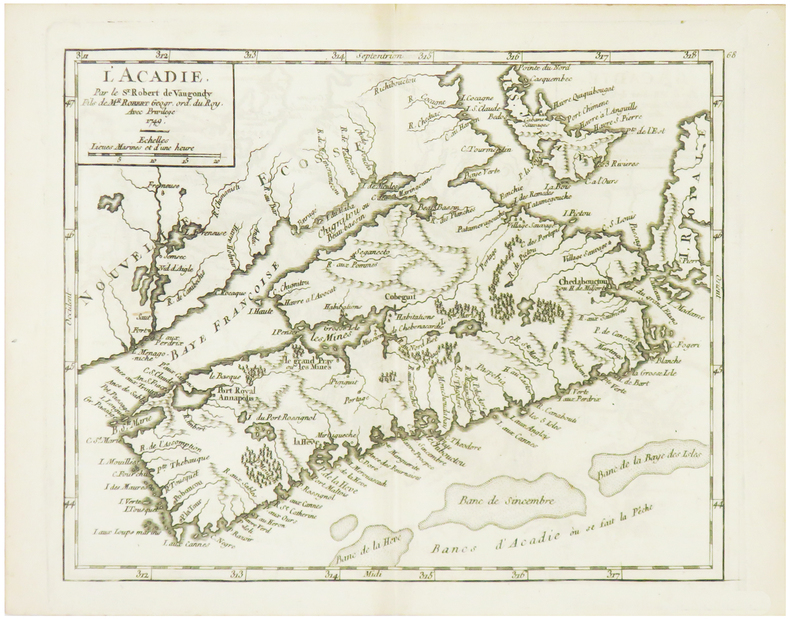
ROBERT de VAUGONDY (Didier).
[ACADIE] L'Acadie.
1749. 162 x 202 mm.
Bookseller reference : LBW024d5
|
|
|
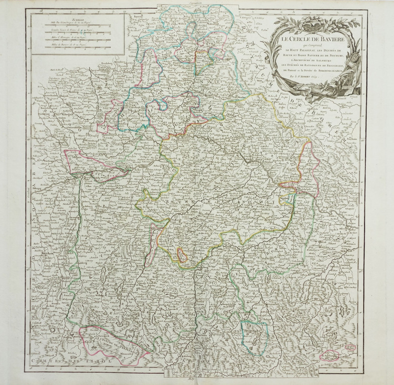
ROBERT de VAUGONDY (Didier).
[BAVIERE] Le Cercle de Bavière qui comprend le Haut Palatinat, Les duchés de Haute et Basse Bavière et de Neuburg, l'archevêché de Salzburg, les évêchés de Ratisbonne, de Freisingen, de Passaui et la prévôté de Berchtolsgaden.
vers 1768. 500 x 448 mm.
Bookseller reference : LBW-1957
|
|
|
ROBERT de VAUGONDY (Didier);
[BELGIQUE] La principauté de Liège et le duché de Limbourg.
1754 486 x 454 mm.
Bookseller reference : LBW03937
|
|
|
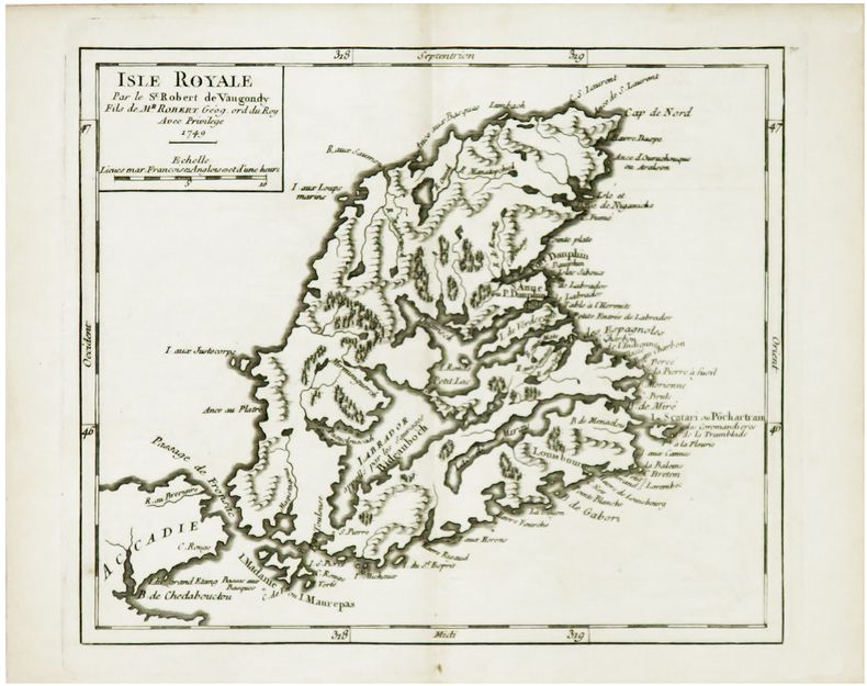
ROBERT de VAUGONDY (Didier).
[CAP-BRETON] Isle Royale.
1749. 163 x 192 mm.
Bookseller reference : LBW024d6
|
|
|
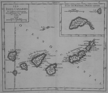
ROBERT de VAUGONDY (Didier).
[CANARIES] Les Isles Canaries.
1749. 163 x 191 mm.
Bookseller reference : LBW024fd
|
|
|
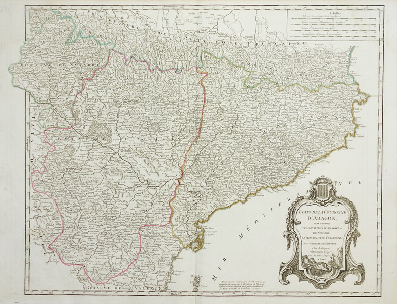
ROBERT de VAUGONDY (Didier).
[CATALOGNE] Etats de la couronne d'Aragon, où se trouvent les royaumes d'Aragon et de Navarre, la principauté de Catalogne.
vers 1780. 480 x 620 mm.
Bookseller reference : LBW-1951
|
|
|
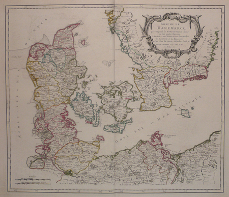
ROBERT de VAUGONDY (Didier);
[DANEMARK] Royaume de Danemarck, qui comprend le Nort-Jutland divisé en ses quatre diocèses, le Sud-Jutland divisé en ses deux duchés de Sleswick et de Holstein, et les isles de Fionie, Selande, Laland, &c.
1750 485 x 565 mm.
Bookseller reference : LBW03943
|
|
|
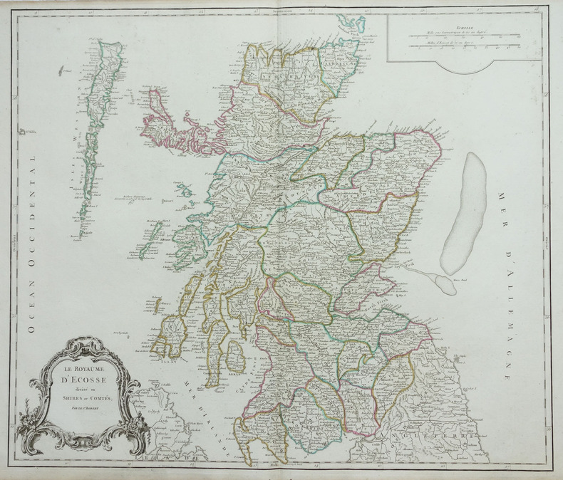
ROBERT de VAUGONDY (Didier).
[ECOSSE] Le Royaume d'Ecosse divisé en shires ou comtés.
1768. 485 x 570 mm.
Bookseller reference : LBW-1892
|
|
|
ROBERT de VAUGONDY (Didier).
[ESTONIE/LETTONIE/LITUANIE] Curlande, Livonie, Ingrie et partie méridionale de Finlande.
1748. 163 x 184 mm.
Bookseller reference : LBW027c3

|
|
|
ROBERT de VAUGONDY (Didier).
[GALICE] Partie septentrionale des états de Castille où se trouve le royaume de Gallice.
1749. 165 x 193 mm.
Bookseller reference : LBW024f5

|
|
|
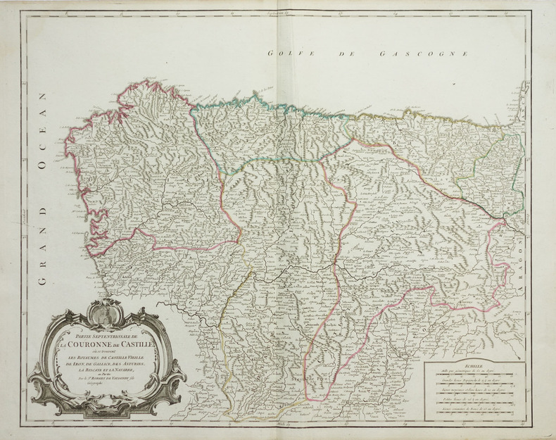
ROBERT de VAUGONDY (Didier).
[GALICE/PAYS BASQUE] Partie septentrionale de la couronne de Castille où se trouvent les royaumes de Castille Vieille, de Léon, de Gallice, des Asturies, la Biscaye et la Navarre, en partie.
vers 1768. 480 x 590 mm.
Bookseller reference : LBW-1919
|
|
|
ROBIQUET (Aimé).
[GOLFE du LION] Côtes de France sur la Méditerranée. Golfe de Lyon d'après les travaux exécutés dans les années 1839 à 1846.
Paris, Robiquet, 1856. 610 x 894 mm.
Bookseller reference : LBW-8305

|
|
|
ROBERT de VAUGONDY (Didier).
[GUYANE] Partie orientale de la Terre Ferme où l'on trouve la Guiane. Partie orientale du Fl. Maragnon ou Amazone.
1749. 160 x 224 mm.
Bookseller reference : LBW-4796

|
|
|
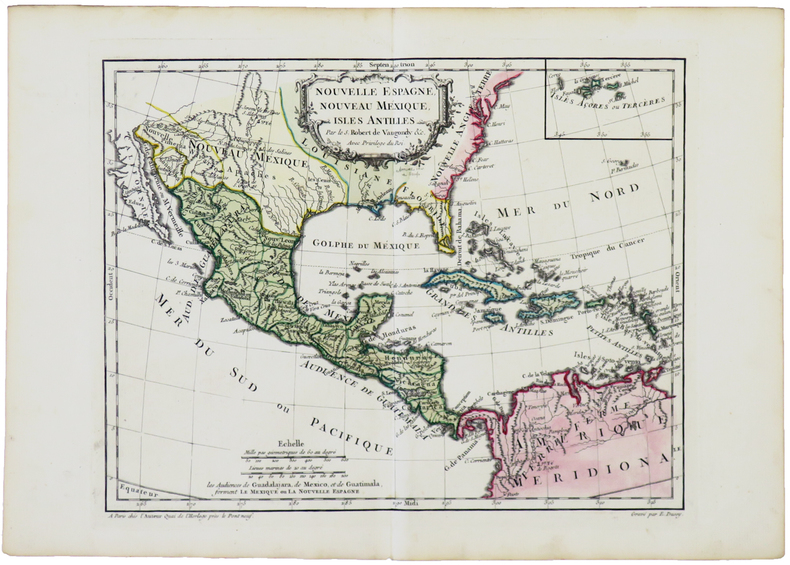
ROBERT de VAUGONDY (Didier).
[MEXIQUE] Nouvelle Espagne, Nouveau Mexique, Isles Antilles.
[1762]. 237 x 306 mm.
Bookseller reference : LBW-5041
|
|
|
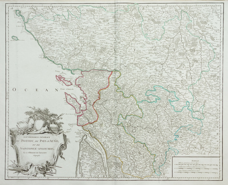
ROBERT de VAUGONDY (Didier).
[POITOU] Gouvernemens généraux du Poitou, du pays d'Aunis, et de Saintonge-Angoumois.
vers 1768. 480 x 589 mm.
Bookseller reference : LBW-1955
|
|
|
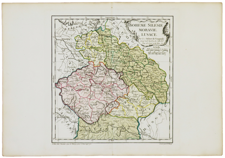
ROBERT de VAUGONDY (Didier).
[RÉPUBLIQUE TCHÈQUE] Bohême Silésie, Moravie, Lusace.
Paris, chez l'auteur, [1762]. 240 x 229 mm.
Bookseller reference : LBW-5040
|
|
|
ROBERT de VAUGONDY (Didier).
[TERRE-NEUVE] Isle de Terre-Neuve.
1749. 171 x 190 mm.
Bookseller reference : LBW024d7

|
|
|
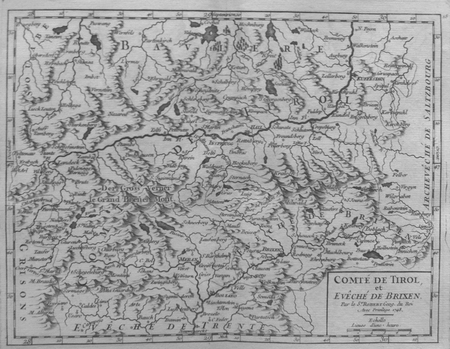
ROBERT de VAUGONDY (Didier);
[TYROL] Comté de Tirol et évêché de Brixen.
1748 161 x 211 mm.
Bookseller reference : LBW027ac
|
|
|
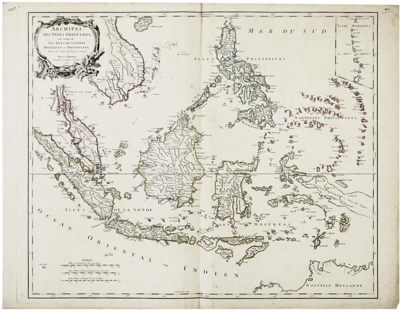
ROBERT de VAUGONDY (Didier).
Archipel des Indes Orientales, qui comprend les isles de la Sonde, Moluques et Philippines.
Venise, P. Santini, 1778. 481 x 590 mm.
Bookseller reference : LBW-795

|
|
|
ROBERT de VAUGONDY (Didier).
Archipel des Indes Orientales, qui comprend les isles de la Sonde, Moluques et Philippines.
1750. 480 x 592 mm.
Bookseller reference : LBW-6421
|
|
|
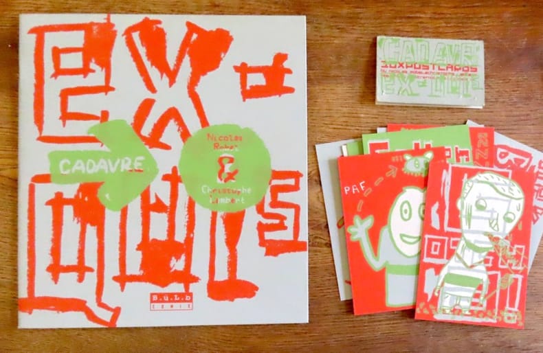
Robel Nicolas, Lambert Christophe:
Cadavre exquis / avec 10 cartes postales.
B.ü.L.b Comix, 2000. In-4 broché, couverture à grands rabats. On joint les 10 cartes au format 9 x 13 cm.
Bookseller reference : 19488
|
|
|
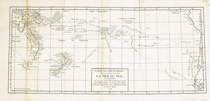
ROBERT de VAUGONDY (Didier);
Carte des découvertes faites en 1765, 67 et 69 dans la mer du Sud.
1774 235 x 535 mm.
Bookseller reference : LBW-611
|
|
|
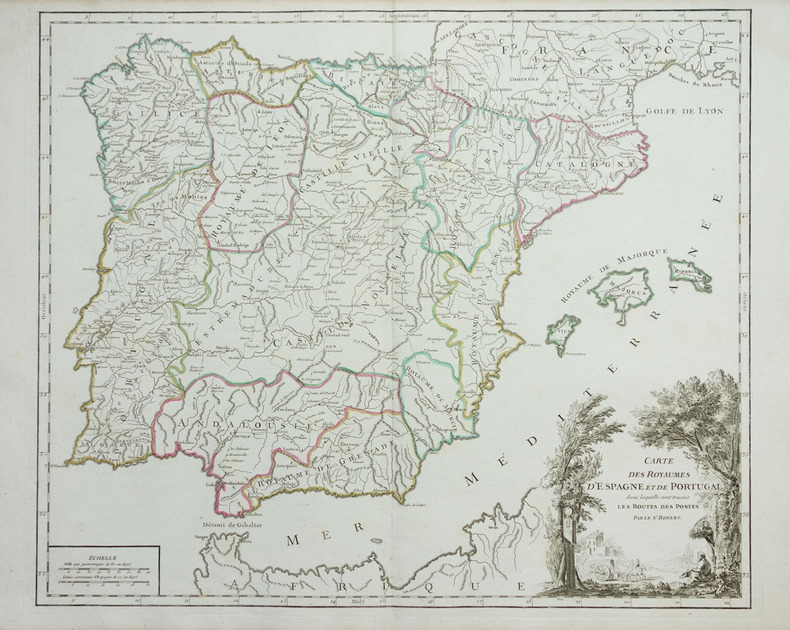
ROBERT de VAUGONDY (Didier).
Carte des royaumes d'Espagne et de Portugal dans laquelle sont tracées les routes des postes.
vers 1768. 480 x 575 mm.
Bookseller reference : LBW-1948
|
|
|
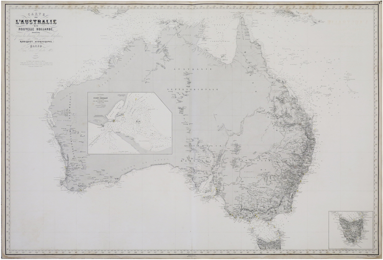
ROBIQUET (Aimé).
Carte de l'Australie ou Nouvelle Hollande, dressée d'après les derniers documents anglais.
Paris, 1863. 0,68 x 1 m.
Bookseller reference : LBW-6812
|
|
|
ROBERT de VAUGONDY (Didier).
Congo ou Basse Guinée.
1749. 165 x 170 mm.
Bookseller reference : LBW024c2
|
|
|
ROBERT DE VAUGONDY (Didier)
Gouvernement général d'Orléanois. où se trouvent l'Orléanois propre, le Blaisois, le Gâtinois, et la Beauce, qui comprend le Vendômois, le Dunois, et le pays chartrain. Par le Sr Robert de Vaugondy fils
[Paris], 1753 carte in-folio (52 x 67 cm), contours rehaussés de couleurs, en feuille.
Bookseller reference : 223214
|
|
|
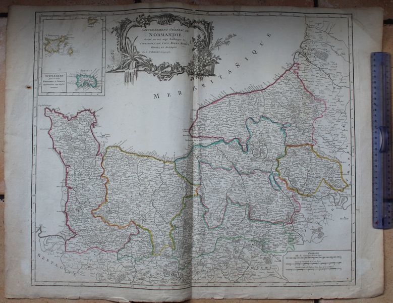
ROBERT DE VAUGONDY (Gilles).
Gouvernement Général de Normandie, divisé en sept baillages, de Coutances, Caen, Caux, Rouen, Evreux, Gisors, et Alençon. Par le Sr Robert Géographe.
S.l. (Paris), Robert, circa 1750. Carte : 77 cm x 56 cm. Titre dans un beau cartouche gravé, limites colorées, pliure centrale, petites déchirures réparées en marge, manque de papier marginal réparé en haut de la pliure.
Bookseller reference : 17617
|
|
|
ROBERT de VAUGONDY (Didier).
Hémisphère céleste Arctique ou septentrional - Hémisphère céleste Antarctique ou austral.
Paris, Sr. Delamarche, 1763. Deux feuilles, chacune de 672 x 637 mm.
Bookseller reference : LBW-6255

|
|
|
Roberta Bernstein , Edith Devaney
Jasper Johns : Une forme de ressemblance avec le vrai
, Fonds Mercator 2017, 2017 Hardcover, 263 pages, Texte en Francais, 300 x 280 mm, Tres belle exemplaire ! Beaucoup illustrations de couleur,. ISBN 9789462301894.
Bookseller reference : 56174
|
|
|
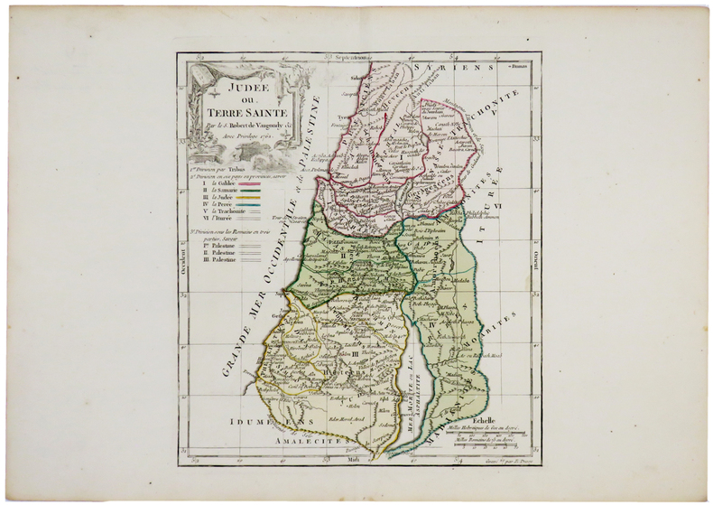
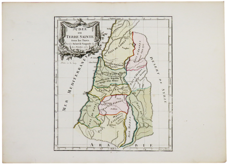
ROBERT de VAUGONDY (Didier).
Judée ou Terre Sainte.
Paris, chez l'auteur, 1762. 242 x 214 mm.
Bookseller reference : LBW-5171

|
|
|
ROBERT de VAUGONDY (Didier).
Judée ou Terre Sainte.
Paris, chez l'auteur, 1762. 242 x 213 mm.
Bookseller reference : LBW-5143
|
|
|
ROBERT de VAUGONDY (Didier).
Judée ou Terre Sainte.
Paris, chez l'auteur, 1762. 241 x 212 mm.
Bookseller reference : LBW-5174
|
|
|
ROBERT de VAUGONDY (Didier).
Judée ou Terre Sainte.
Paris, chez l'auteur, 1762. 242 x 214 mm.
Bookseller reference : LBW-5187

|
|
|
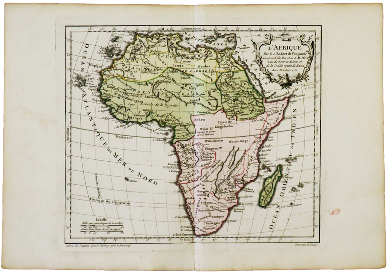
ROBERT de VAUGONDY (Didier).
L'Afrique.
Paris, chez l'auteur, [1762]. 238 x 280 mm.
Bookseller reference : LBW-4994
|
|
|
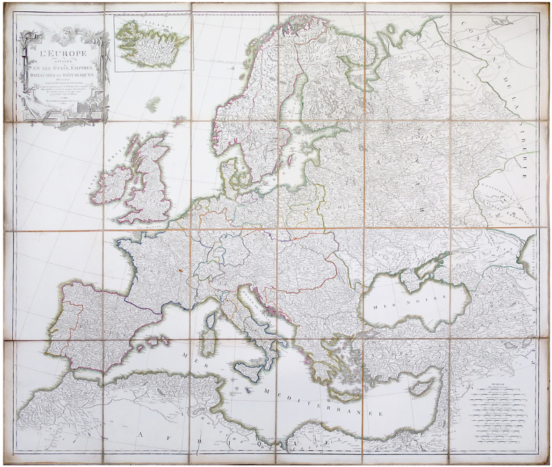
ROBERT de VAUGONDY (Didier).
L'Europe divisée en ses états, empires, royaumes et républiques.
Paris, C.F. Delamarche, [circa 1805]. En 24 sections montées sur toile et pliées, formant une carte de 1 x 1,14 m.
Bookseller reference : LBW-6489
|
|
|
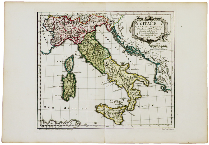
ROBERT de VAUGONDY (Didier).
L'Italie.
Paris, chez l'auteur, [1762]. 240 x 280 mm.
Bookseller reference : LBW-5043
|
|
|
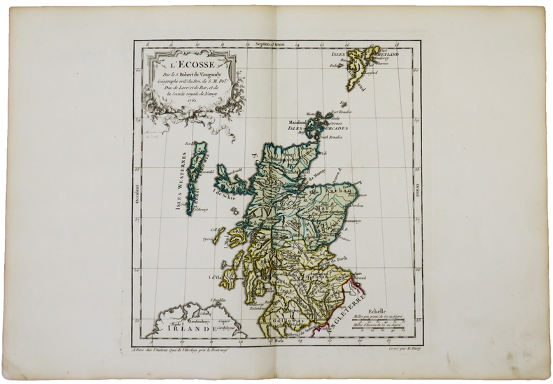
ROBERT de VAUGONDY (Didier).
L'Écosse.
Paris, chez l'auteur, 1762. 238 x 223 mm.
Bookseller reference : LBW-5022
|
|
|
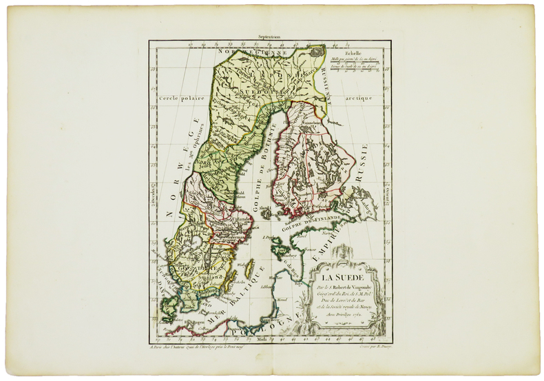
ROBERT de VAUGONDY (Didier).
La Suède.
Paris, chez l'auteur, 1762. 238 x 190 mm.
Bookseller reference : LBW-5024
|
|
|
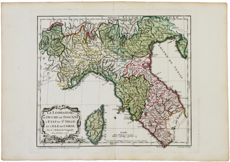
ROBERT de VAUGONDY (Didier).
La Lombardie, le Duché de Toscane, l'État du St. Siège, et l'isle de Corse.
Paris, chez l'auteur, 1762. 239 x 280 mm.
Bookseller reference : LBW-5044
|
|
 Receive by email
 Download as PDF document
 RSS feed


