|
Regards. Gérant : Zeyons
Regards En couverture : Les dessous des cartes. Révélations sur la presse françaiseM. Boussac - M. Dubridet veut fonder un journal (Louis Maréchot) - Les journaux communistes et démocratiques mènent l'offensive - Au service de la vérité (Serge Zeyons, photos Jacques Kanapa) - Les journaux qui vous défendent, vous conseillent, vous distraient - Des ouvriers imprimeurs vous racontent (eux-même) la naissance de "Regards" - Le journal des lecteurs. L'insigne, nouvelle de Paul Saux - Travailleurs de France - Gosses de Paris et d'ailleurs - Akoutou, et le préjugé du Zoe, nouvelle de Fozoo Ekabe (Cameroun) - Vallauris la pacifique (reportage photo André Villers) - Poèmes pour la paix - Une petite ville - Dans le monde des champignons - ...
n° 371 - novembre 1953 - nouvelle série - revue illustrée - in-4 broché - 50 pages
Bookseller reference : 60930
|
|
|
REGNE Jean
R?pertoire des plans cadastraux parcellaires de l'Ard?che. Lettre-pr?face de Marc Bloch.
Broch?. 70 pages. Couverture en mauvais ?tat. Importantes rousseurs.
|
|
|
REGUIN Olivier:
Saint-Georges. Village, prieuré et seigneurie à la fin du Moyen Age.
Lausanne, Bibliothèque Historique Vaudoise, 2000. In-8 broché de 219 pages, couverture illustrée en couleurs.
Bookseller reference : 1104

|
|
|
REICH HANS/ VALK MAPS.
KINDEREN UIT HEEL DE WERELD.
Den Haag Nederlandse Boekenclub 1958. . Gebonden originele geillustreerde uitgeversomslag in kleur 185x235cm 119pp rijkelijk geillustreerd z/w. Den Haag, Nederlandse Boekenclub, 1958. unknown
Bookseller reference : 9746
|
|
|
Reich, Erhard - Ortelius, Abraham
Palatinatus Bavariae descriptio, Erhardo Reych Tirolense Auctore. [um 1590]. [Altkolorierter Original-Kupferstich, gerahmt / old colored original copper engraving, framed]
o.J. Abraham Ortelius, geboren am 4. oder 14. April 1527 in Antwerpen, gestorben am 28. Juni 1598 ebenda. Flämischer Geograph und Kartograf. [3 Warenabbildungen]
Bookseller reference : 59507BB

|
|
|
REICH, HANS/ VALK, MAPS.
KINDEREN UIT HEEL DE WERELD.
, Den Haag, Nederlandse Boekenclub, 1958., Gebonden, originele geillustreerde uitgeversomslag in kleur, 18,5x23,5cm, 119pp, rijkelijk geillustreerd z/w.
Bookseller reference : 9746
|
|
|
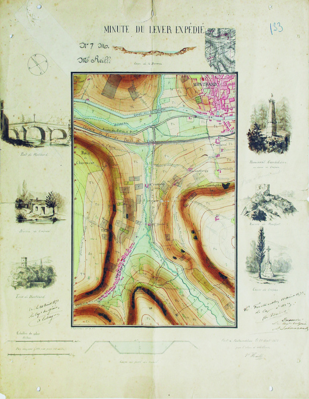
REILLE (Victor).
Minute du lever expédié.
Fontainebleau, 1871. 47,8 x 38,3 cm.
Bookseller reference : LBW-6565
|
|
|
Reilly, Franz Johann Joseph von
Das Herzogthum Geldern. Kurbrandenburgischen Antheils mit dem Fürstenthume Mörs. Nro. 268 (um 1790). [Altkolorierter Kupferstich, gerahmt / handcoloured copper engraving, framed].
o.J. [3 Warenabbildungen] (Franz Johann Joseph von Reilly, geb. 18.08.1766 in Wien, gest, 06.07.1820 ebenda, österreichischer Verleger, Kartograf
Bookseller reference : 66102CB

|
|
|
Reilly, Franz Johann Joseph von
Das Koenigreich Sklavonien und Herzogthum Syrmien (No. 3). Teilkolorierte Kupferstichkarte aus "Schauplatz der fünf Theile der Welt".
Wien, Reilly, ca. 1789. 20 x 29 cm (Blattgröße 22 x 32 cm).
Bookseller reference : 110609

|
|
|
Reilly, Franz Johann Joseph von
Der gefürsteten Grafschaft Tirol Viertel Unterinn und Wipp-Thal. Teilkolorierte Kupferstichkarte (No. 146) aus "Schauplatz der fünf Theile der Welt".
Wien, Reilly, ca. 1791. 22 x 29 cm (Blattgröße 24 x 32 cm).
Bookseller reference : 110618

|
|
|
Reilly, Franz Johann Joseph von:
Das Koenigreich Sklavonien und Herzogthum Syrmien (No. 3). Teilkolorierte Kupferstichkarte aus "Schauplatz der fünf Theile der Welt".
20 x 29 cm (Blattgröße 22 x 32 cm). *Reilly ist bekannt für seine exakten Detailkarten, die vorliegende Karte Slowenien mit Belgrad im Osten und die Kleine Walachei mit Kialiova im Westen (linke Ecke oben mit leichtem Fleck). - Map from the Atlas of Reilly`s "Schauplatz der fünf Theile der Welt", which appeared 1789 to 1806 in 3 parts with more than 1000 maps of Europe. This atlas is famous for his exact and detailed maps. - Original copperplate engraving [Vienna, about 1789]. Some original colouring, good condition. Landkarten de
|
|
|
Reilly, Franz Johann Joseph von:
Der gefürsteten Grafschaft Tirol Viertel Unterinn und Wipp-Thal. Teilkolorierte Kupferstichkarte (No. 146) aus "Schauplatz der fünf Theile der Welt".
22 x 29 cm (Blattgröße 24 x 32 cm). *Reilly ist bekannt für seine exakten Detailkarten, die vorliegende Karte zeigt das Österreichische Teilgebiet Unterinn mit Kufstein im Norden. - Map from the Atlas of Reilly`s "Schauplatz der fünf Theile der Welt", which appeared 1789 to 1806 in 3 parts with more than 1000 maps of Europe. This atlas is famous for his exact and detailed maps. - Original copperplate engraving [Vienna, 1789]. Some original colouring, good condition. Landkarten de
|
|
|
Reilly, Franz Johann Joseph von:
Die Markgrafschaft Niederlausitz chursächsischen und preussischen Antheils und in ihre Kreise eingetheilt. Nro 104"
22 x 29 cm. Blattgröße 30 x 42 cm. Teilkolorierte Kupferstichkarte. *Reilly ist bekannt für seine exakten Detailkarten, die vorliegende Karte zeigt das Gebiet der Niederlausitz mit Lübben, Spreewald, Cottbus und Guben. Aus dem Werk "Aus: Schauplatz der fünf Theile der Welt". - Sehr gut erhalten. Landkarten de
|
|
|
Reilly, Franz Johann Joseph von:
Generalkarte von Spanien und Portugal. Landkarte No. 524 aus dem Atlas von Reilly "Schauplatz der fünf Theile der Welt" (1789-1806).
23 x 28 cm (Blattgröße 33 x 52 cm). Teilkolorierte Kupferstichkarte. *Reilly ist bekannt für seine exakten Detailkarten, die vorliegende Karte zeigt die gesamte Iberische Halbinsel. - Sehr gut erhalten. - Map from the Atlas of Franz Johann Joseph von Reilly "Schauplatz der fünf Theile der Welt", which appeared 1789 to 1806 in 3 parts with more than 1000 maps of Europe. This atlas is famous for his exact and detailed maps. Here one map of the Iberian part - No. 524 (General map of Spain and Portugal). - Fine condition. Landkarten de
|
|
|
Reilly, Franz Johann Joseph von:
Karte von dem Königreiche Slavonien. Neunzehende Schulkarte ... aus "Schul Atlas" herausgegeben von F.I.I. von Reilly und zu finden im Verlage des Herausgebers.
Blattgröße 30 x 44,5 cm. Teilkolorierte Kupferstichkarte. *Reilly ist bekannt für seine exakten Detailkarten, die vorliegende Karte zeigt das gesamte Slavonien in Flächenkolorit. - Karte aus dem Schul-Atlas "Schulkarte zu ... der Erdbeschreibung zum Gebrauche der studirenden Jugend in den Kaiserlichen Königlichen Staaten". Dieser frühe Österreichische Schulatlas wurde von dem Landkartenstecher Reilly angefertigt und ist recht selten. Die Karten sind hier etwas größer als in seinem gleichzeitig begonnenen Hauptwerk "Schauplatz ...". - Leicht gebräunt, insgesamt gut erhalten. Landkarten de
|
|
|
Reilly, Franz Johann Joseph von:
Karte von den Königreichen Gallizien und Lodomerien den Herzogthümern Auschwitz und Zator und der Landschaft Bukovina. Zwanzigste Schulkarte ... aus "Schul Atlas" herausgegeben von F.I.I. von Reilly und zu finden im Verlage des Herausgebers.
Blattgröße 30 x 44,5 cm. Teilkolorierte Kupferstichkarte. *Reilly ist bekannt für seine exakten Detailkarten, die vorliegende Karte mit Grenz- und Flächenkolorit. - Karte aus dem Schul-Atlas "Schulkarte zu ... der Erdbeschreibung zum Gebrauche der studirenden Jugend in den Kaiserlichen Königlichen Staaten". Dieser frühe Österreichische Schulatlas wurde von dem Landkartenstecher Reilly angefertigt und ist recht selten. Die Karten sind hier etwas größer als in seinem gleichzeitig begonnenen Hauptwerk "Schauplatz ...". - Leicht gebräunt, insgesamt gut erhalten. Landkarten de
|
|
|
Reilly, Franz Johann Joseph von:
Karte von Europa überhaupt und der Östreichischen Monarchie insbesondere. Zweyte Schulkarte ... aus "Schul Atlas" herausgegeben von F.I.I. von Reilly und zu finden im Verlage des Herausgebers.
Blattgröße 30 x 44,5 cm. Teilkolorierte Kupferstichkarte. *Reilly ist bekannt für seine exakten Detailkarten, die vorliegende Karte zeigt Europa. - Karte aus dem Schul-Atlas "Schulkarte zu ... der Erdbeschreibung zum Gebrauche der studirenden Jugend in den Kaiserlichen Königlichen Staaten". Dieser frühe Österreichische Schulatlas wurde von dem Landkartenstecher Reilly angefertigt und ist recht selten. Die Karten sind hier etwas größer als in seinem gleichzeitig begonnenen Hauptwerk "Schauplatz ...". - Sehr gut erhalten. Landkarten de
|
|
|
Reilly, Franz Johann Joseph von:
Karte von Oberhungarn in die zween Kreise diesseits und jenseits der Theyss abgetheilt. Siebenzehende Schulkarte ... aus "Schul Atlas" herausgegeben von F.I.I. von Reilly und zu finden im Verlage des Herausgebers.
Blattgröße 30 x 44,5 cm. Teilkolorierte Kupferstichkarte. *Reilly ist bekannt für seine exakten Detailkarten, die vorliegende Karte zeigt das östliche Ungarn. - Karte aus dem Schul-Atlas "Schulkarte zu ... der Erdbeschreibung zum Gebrauche der studirenden Jugend in den Kaiserlichen Königlichen Staaten". Dieser frühe Österreichische Schulatlas wurde von dem Landkartenstecher Reilly angefertigt und ist recht selten. Die Karten sind hier etwas größer als in seinem gleichzeitig begonnenen Hauptwerk "Schauplatz ...". - Leicht gebräunt, insgesamt gut erhalten. Landkarten de
|
|
|
Reilly, Franz Johann Joseph von:
Karte von Oberoestreich oder der Grafschaft Tirol. Sechste Schulkarte ... aus "Schul Atlas" herausgegeben von F.I.I. von Reilly und zu finden im Verlage des Herausgebers.
Blattgröße 29,5 x 40 cm. Teilkolorierte Kupferstichkarte. *Reilly ist bekannt für seine exakten Detailkarten, die vorliegende Karte zeigt Gebiet Tirol vom von der Bayerischen und Schwäbischen Grenze im Norden bis zum Gardasee im Süden mit leichtem Grenz- und Flächenkolorit. - Karte aus dem Schul-Atlas "Schulkarte zu ... der Erdbeschreibung zum Gebrauche der studirenden Jugend in den Kaiserlichen Königlichen Staaten". Dieser frühe Österreichische Schulatlas wurde von dem Landkartenstecher Reilly angefertigt und ist recht selten. Die Karten sind hier etwas größer als in seinem gleichzeitig begonnenen Hauptwerk "Schauplatz ...". - Sehr gut erhalten. Landkarten de
|
|
|
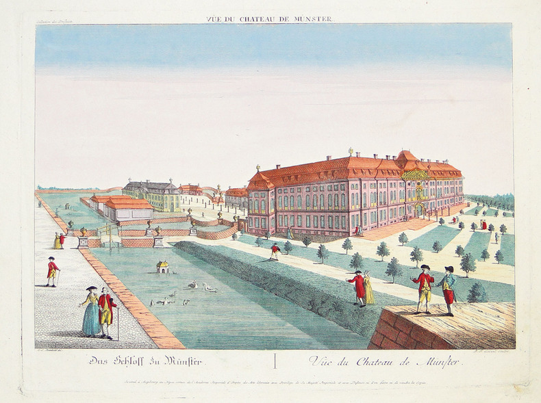
REINHOLD (Christian Ludolph) & LEIZELT (Balthasar Friedrich).
[MÜNSTER] Vüe du château de Münster.
Augsbourg, Négoce commun de l'Académie Impériale d'Empire des Arts Libéraux, [circa 1790]. 307 x 400 mm.
Bookseller reference : LBW-2792
|
|
|
Reischauer Edwin O. & Fairbank John K. and 80 plates charts maps tbls
East Asia: The Modern Transformation History of East Asian Civilization Volume II
Hardcover. Very Good. hardcover
Bookseller reference : FY-CCOI-PYW8
|
|
|
REMIREMONT
Carte d'Etat-Major au 1/200 000e. Fin XIXe.
1 feuille repli?e. 32x49 cm.
|
|
|
Remond (Martial) :
La Kabylie. Préface de Marcel Larnaude. Ouvrage orné de 16 hors-texte et de 17 cartes et itinéraires. Dessins de Mme Kleiss-Herzig - Photos de l'auteur.
Alger, Editions Baconnier, 1937 ; in-8 (205 mm), broché ; 157, [1] pp., 16 ff. hors-texte de photographies en héliogravures, portraits, scènes et paysages, couverture illustrée d'un portrait en couleur par Mme Yvonne Kleiss-Herzig.
Bookseller reference : 20384

|
|
|
REMONDINI Tipografia (Bassano 1650 - 1860)
Carte generale du globe terrestre construite & publiee par le S.r Jsaac Brouckner geographe de S.M.I.C. exaninee & approuvee
Raro planisfero pubblicato a Venezia dalla tipografia Remondini ed occasionalmente inserito nel Dizionario geografico portatile, 1761.Interessante mappa del mondo presentata nella proiezione di Mercator e centrata sull'Australia.La Groenlandia è mostrata collegata al Nord America. Il titolo riporta che la mappa fu approvata da Daniel Bernoulli (1700-1782), medico, fisico e matematico olandese, attivo a San Pietroburgo e in Svizzera. Acquaforte, consuete pieghe di carta, leggere ossidazioni, per il resto in ottimo stato di conservazione. Unusual world map by Remondini, taken from Dizionario Geografico portatile. After Isaac Brouckner.Attractive Italian world map presented in Mercator's projection and centered on Australia. Featuring the voyage of Spanberg, among others in the years of 1709-1739. Greenland is shown connected to North America. According to the title the map was approved by Daniel Bernoulli (1700-1782), Dutch physician, physicist and mathematician, active in St. Petersburg and Switzerland.Printed by Remondini, who was a famous publisher of prints and books all with a popular character. He flourished in Bassano in 1661 and was active until 1860.Founded by Giovanni Antonio Remondini (1634 - 1711), the house reached its peak in the second half of the eighteenth century, under the leadership of Joseph Remondini (1745 - 1811).

|
|
|
Renati Des Cartes
"Geometria"" Renati Des-Cartes 1659
2019. Paperback. New. Reprinted in 2019 with the help of original edition published long back 1659. This book is Printed in black & white sewing binding for longer life with Matt laminated multi-Colour Soft Cover HARDCOVER EDITION IS ALSO AVAILABLE Printed on high quality Paper re-sized as per Current standards professionally processed without changing its contents. As these are old books we processed each page manually and make them readable but in some cases some pages which are blur or missing or black spots. If it is multi volume set then it is only single volume if you wish to order a specific or all the volumes you may contact us. We expect that you will understand our compulsion in these books. We found this book important for the readers who want to know more about our old treasure so we brought it back to the shelves. Any type of Customisation is possible with extra charges. Hope you will like it and give your comments and suggestions. paperback
Bookseller reference : PB1111015585471
|
|
|
Renati Des Cartes
"Geometria"" Renati Des-Cartes 1659 Leather Bound
2019. Leather Bound. New. Leather Binding on Spine and Corners with Golden Leaf Printing on round Spine extra customization on request like complete leather Golden Screen printing in Front Color Leather Colored book etc. Reprinted in 2019 with the help of original edition published long back 1659. This book is printed in black & white sewing binding for longer life Printed on high quality Paper re-sized as per Current standards professionally processed without changing its contents. As these are old books we processed each page manually and make them readable but in some cases some pages which are blur or missing or black spots. If it is multi volume set then it is only single volume if you wish to order a specific or all the volumes you may contact us. We expect that you will understand our compulsion in these books. We found this book important for the readers who want to know more about our old treasure so we brought it back to the shelves. Hope you will like it and give your comments and suggestions. Lang: - . EXTRA 10 DAYS APART FROM THE NORMAL SHIPPING PERIOD WILL BE REQUIRED FOR LEATHER BOUND BOOKS. COMPLETE LEATHER WILL COST YOU EXTRA US$ 25 APART FROM THE LEATHER BOUND BOOKS. hardcover
Bookseller reference : LB1111015585471
|
|
|
Renati Des Cartes
"Geometria"" Renati Des-Cartes 1659 FULL LEATHER BOUND
2019. SUPER DELUXE EDITION. New. Antique look with Golden Leaf Printing and embossing with round Spine completely handmade bindingextra customization on request like Color Leather Colored book special gold leaf printing etc. Reprinted in 2019 with the help of original edition published long back 1659. This book is printed in black & white sewing binding for longer life Printed on high quality Paper re-sized as per Current standards professionally processed without changing its contents. As these are old books we processed each page manually and make them readable but in some cases some pages which are blur or missing or black spots. If it is multi volume set then it is only single volume if you wish to order a specific or all the volumes you may contact us. We expect that you will understand our compulsion in these books. We found this book important for the readers who want to know more about our old treasure in old look so we brought it back to the shelves. Hope you will like it and give your comments and suggestions. EXTRA 10 DAYS APART FROM THE NORMAL SHIPPING PERIOD WILL BE REQUIRED. Normal Hardbound Edition is also available on request. unknown
Bookseller reference : SD1111015585471
|
|
|
Renati Des Cartes
"Geometria"" Renati Des-Cartes 1659 Hardcover
2019. Hardcover. New. Reprinted in 2019 with the help of original edition published long back 1659. This book is Printed in black & white Hardcover sewing binding for longer life with Matt laminated multi-Colour Dust Cover Printed on high quality Paper re-sized as per Current standards professionally processed without changing its contents. As these are old books we processed each page manually and make them readable but in some cases some pages which are blur or missing or black spots. If it is multi volume set then it is only single volume if you wish to order a specific or all the volumes you may contact us. We expect that you will understand our compulsion in these books. We found this book important for the readers who want to know more about our old treasure so we brought it back to the shelves. Any type of Customisation is possible with extra charges. Hope you will like it and give your comments and suggestions. hardcover
Bookseller reference : 1111015585471
|
|
|
Renati Des Cartes
Musicae compendium 1656 Hardcover
2017. Hardcover. New. Size: 14.34 x 22.59 cms Lang: - Latin Pages 42. Reprinted in 2017 with the help of original edition published long back 1656. This book is Printed in black & white Hardcover sewing binding for longer life with Matt laminated multi-Colour Dust Cover Printed on high quality Paper re-sized as per Current standards professionally processed without changing its contents. As these are old books we processed each page manually and make them readable but in some cases some pages which are blur or missing or black spots. If it is multi volume set then it is only single volume if you wish to order a specific or all the volumes you may contact us. We expect that you will understand our compulsion in these books. We found this book important for the readers who want to know more about our old treasure so we brought it back to the shelves. Hope you will like it and give your comments and suggestions. hardcover
Bookseller reference : 1111004040010 ISBN : 888800694919x 8888006949

|
|
|
Renati Des Cartes
Musicae compendium 1656
2017. Softcover. New. Size: 13.34 x 21.59 cms Lang: - Latin Pages 42. Reprinted in 2017 with the help of original edition published long back 1656. This book is Printed in black & white sewing binding for longer life with Matt laminated multi-Colour Soft Cover HARDCOVER EDITION IS ALSO AVAILABLE Printed on high quality Paper re-sized as per Current standards professionally processed without changing its contents. As these are old books we processed each page manually and make them readable but in some cases some pages which are blur or missing or black spots. If it is multi volume set then it is only single volume if you wish to order a specific or all the volumes you may contact us. We expect that you will understand our compulsion in these books. We found this book important for the readers who want to know more about our old treasure so we brought it back to the shelves. Hope you will like it and give your comments and suggestions. paperback
Bookseller reference : PB1111004040010 ISBN : 4444006600899 4444006600

|
|
|
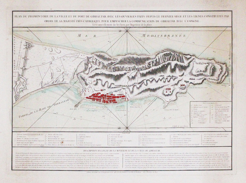
RENAUD (Chevalier).
[GIBRALTAR] Plan du promontoire, de la ville et du port de Gibraltar avec les ouvrages faits depuis le dernier siège et les lignes construites par ordre de Sa Majesté Très Catholique, pour empescher la communication de Gibraltar avec l'Espagne. Levé nouvellement sur les lieux par l'ingénieur de la place.
Paris, Lattré, [circa 1780]. 400 x 550 mm.
Bookseller reference : LBW-3315
|
|
|
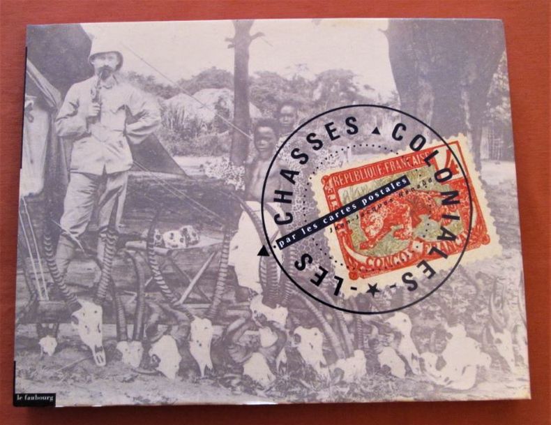
RENAUD (Jean-Jacques)
Les chasses coloniales par les cartes postales. (Chasse en Afrique).
Le Faubourg (1 janvier 1993). In-4 à l'talienne, reliure pleine toile et jaquette illustrée (22 x 28,7 cm), 139 pages, album de reproductions photographiques sur cartes postalezs anciennes, sur le thème de la chasse en Afrique.- Ce livre présente une série de cartes postales des colonies françaises correspondant à la période de 1900 à 1920. 995g.- Etat neuf.
Bookseller reference : 30147
|
|
|
RENAUD Alexandre (traduction)
UTAH BEACH à Cherbourg : toute la bataille du Cotentin, 6 juin - 1er juillet 1944.
Editions Leclerc Imprimeur, Saint-Lo, Edité en Amérique par La Division historique du Département de l'Armée, traduit par Alexandre Renaud, sans date, VIII-197 p. et XIV cartes in fine, demi-maroquin à coins marron, environ 28x22cm. Une tache discrète sur le mors-peau du premier plat, premier plat d'origine découpé et contrecollé, un dessin au stylo sur la page de titre, de pâles rousseurs, certaines pages sont un peu froissées, la carte I a été restaurée, de petites déchirures sur les bords des cartes. Bon état pour le reste.
Bookseller reference : 117558

|
|
|
RENAUD Jean-Jacques
Les chasses coloniales par les cartes postales.
Paris: Editions Le Faubourg, 1993 in-4 oblong, 139 pages, nomb. illustrations en noir. Cartonné, jaquette. très bon état. Cartes postales anciennes sur la chasse dans les colonies d'Afrique et d'Asie. ** Oblong 4to. 139 pp., num. monochrome ills. Hb., d.w., very fine. A collection of ancient postal cards with hunting scenes in colonial days in Africa and Asia.
Bookseller reference : 1236874
|
|
|
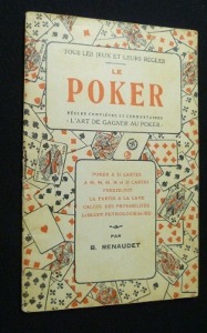
RENAUDET (B.)
Tous les jeux de cartes et leurs règles
Paris, S. Bornemann, 1941. In-8 broché, couv. ill. Fig. in-t. Très bon état (tampon sur 1er plat).Règles et variantes de : Manille, Piquet, L'Ecarté, Poker, Baccara, Belotte, Bridge...
Bookseller reference : 8230
|
|
|
RENAUDET B
Jeux de cartes pour joueurs nombreuxA jouer en famille et en société.
broché - 11,5x17,5 - 31 pp - sans date - éditions S. BORNEMANN, Paris.
Bookseller reference : 1919
|
|
|
RENAUDET B
La manille manille parlée - manille muette - manille avec un mort - le dix sept - manille à l'envers - manille aux enchères - manille de misère - manille à deux joueurs.règles complètes et commentairesLa science du jeu
broché - 11,5x17,5 - 31 pp - sans date - éditions S. BORNEMANN, Paris.
Bookseller reference : 1920
|
|
|
Renaudet B.
Le poker, règles complètes et commentaires. L'art de gagner au poker
Bornemann Tous les jeux et leurs règles Broché In-8, (18x11.5 cm), broché, couverture illustrée, 31 pages, sans date, poker à 52 cartes, à 48, 44, 36 et 32 cartes, freeze-out, la partie à la cave, calcul des probabilités, le bluff, physiologie du jeu ; plats jaunis et légèrement défraîchis, assez bon état. Livraison a domicile (La Poste) ou en Mondial Relay sur simple demande.
Bookseller reference : nf174
|
|
|
RENAUDET B.
Tous les jeux et leurs règles : Le piquet, règles complètes et commentaires, le piquet à 2 joueurs, le piquet à 3 joueurs, le piquet à 4 joueurs, le rubicon, la capote. La science du jeu.
Paris, Librairie S. Bornemann, s.d. 11 x 18, 32 pp., quelques illustrations, broché, bon état (couverture défraîchie).
Bookseller reference : 23686
|
|
|
Rene Albrecht Carrie Maps
Europe after 1815 with Maps Third Edition Paperback Rene Albrecht-Carrie
acceptable. B001BCCWP2 unknown
Bookseller reference : U5-wT14-0509
|
|
|
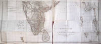
Rennell James
Description historique et g�ographique de l'Indostan traduite de l'anglais par J.B. Bouscheseiche sur la septi�me et derni�re �dition � laquelle on a joint des M�langes d'Histoire et de Statistique sur l'Inde traduits par J. Cast�ra. Atlas
Paris: Buisson Bosange Masson et Besson Treuttel et W�rtz 1800. Livre. Bon. Demi-cuir. Ed. originale. In-8. Paris Buisson Bosange Masson et Besson Treuttel et W�rtz Imp. de Poign�e an VIII 1800. 4 volumes dont un d'atlas. Volumes de texte : 205 x 14 cm R in-8 XXXVIII - 299 2 pp. 410 pp. 362 pp. reliure de l'�poque en demi-basane fauve dos lisses richement orn�s pi�ces de titre et de tomaison toutes tranches jaunes. Volume d'Atlas : 29 x 23 cm R in-4 39 pp. - 11 cartes la plupart d�pliantes et certaines finement rehauss�es de couleurs reliure de l'�poque en demi veau glac� dos lisse orne de filets et fleurons dor�s pi�ce de titre tranches marbr�es. Edition originale de la traduction. Ex-libris h�raldique du comte de Fortis sur chaque premier contreplat des volumes de texte ex-libris h�raldique du vicomte de Bastard d'Estang ch�teau de Dobert sur le 1er contreplat du volume d'Atlas. Bon exemplaire pour le texte magr� les plats frott�s deux coiffes l�g�rement accident�es et des �pidermures et des trous de vers sur les mors tr�s rares rousseurs sur les premiers feuillets. L'atlas tr�s bien reli� comporte tout juste quelques rousseurs dans certaines marges des cartes et constitue un bel exemplaire. Buisson, Bosange, Masson et Besson, Treuttel et W�rtz Hardcover
Bookseller reference : 0651
|
|
|
RENNES
Carte couleurs au 1/200 000?me France en 48 feuilles. Carte n? 14. Sans date.
Une feuille 100x44 cm.
|
|
|
RENOY (Georges)
Bruxelles sous Léopold Ier - 25 ans de cartes porcelaine 1840-1865
Bruxelles, Crédit Communal de Belgique, s.d. In-4 broché, couv. ill. : Grand Café des Mille Colonnes, 192 p. Nombreuses reproductions de cartes en couleurs. Très bon état.
Bookseller reference : 14329
|
|
|
RENOY Georges
"Bruxelles sous Léopold Ier; 25 ans de cartes porcelaine, 1840-1865."
Bruxelles, Crédit Communal de Belgique, 1979. 21 x 30, 192 pp., très nombreuses illustrations en couleurs et en N/B, broché, bon état.
Bookseller reference : 101.308
|
|
|
RENOY Georges
"Bruxelles sous Léopold Ier; 25 ans de cartes porcelaine, 1840-1865."
Bruxelles, Crédit Communal de Belgique, 1979. 21 x 30, 192 pp., très nombreuses illustrations en couleurs et en N/B, broché, bon état (1 pli à la couverture).
Bookseller reference : 101.309
|
|
|
Renoy. Georges.
Brussel onder Leopold I. 25 jaar porseleinenkaarten 1840-1865.
, Brussel, Gemeentekrediet, 1979 , Ingenaaid, In-4, 192 pp., talrijke ills. in zw/w en in kleur, goede staat. ISBN X.
Bookseller reference : 18102
|
|
|
René BOUGARD ( lieutenant de vaisseau ), Cartographe.
Le petit flambeau de la mer ou le veritable guide des pilotes cotiers ; Où il est clairement enseigné la maniere de naviguer le long de toutes les Côtes de France, d'Angleterre, d'Irlande, d'Espagne, de Portugal, d'Italie, de Sicile, de Malte, de Corse & de Sardaigne, & autres isles de Detroit, & des cotes de Barbarie, depuis le Cap Bon jusqu'au Cap Verd comme aussi toutes les demonstrations des cotes de la maniere qu'elles paroissent de la mer, avec l'heure des marées en chaque port, & la chute des courans; de plus les sondes & profondeurs qui se rencontrent tant dedans que dehors le canal, la qualité des fonds avec tous les dangers qui y sont. Les plans & baies des principaux ports & havres y sont demontrés d'une maniere fort intelligible
René BOUGARD ( lieutenant de vaisseau ), Cartographe. Le petit flambeau de la mer ou le veritable guide des pilotes cotiers ; Où il est clairement enseigné la maniere de naviguer le long de toutes les Côtes de France, d'Angleterre, d'Irlande, d'Espagne, de Portugal, d'Italie, de Sicile, de Malte, de Corse & de Sardaigne, & autres isles de Detroit, & des cotes de Barbarie, depuis le Cap Bon jusqu'au Cap Verd comme aussi toutes les demonstrations des cotes de la maniere qu'elles paroissent de la mer, avec l'heure des marées en chaque port, & la chute des courans; de plus les sondes & profondeurs qui se rencontrent tant dedans que dehors le canal, la qualité des fonds avec tous les dangers qui y sont. Les plans & baies des principaux ports & havres y sont demontrés d'une maniere fort intelligible comme aussi tous les amers, & plusieurs autres plans et baies qui se rencontrent en allant aux Indes Orientales & une table des variations qui se trouvent tant en allant que revenant des Indes. Derniere edition par le feu Sieur Bougard, Lieutenant sur les vaisseaux du Roi revu, corrigé & augmenté. 1742, Au Havre de Grace chez la Veuve de Guillaume Gruchet, Imprimeur & marchand libraire; Avec privilege du Roy. 1 vol. in-8 relié de 415 pages + table non chiffrée. Reliure de l'époque plein vélin. Petits manques de vélin en bordure inférieure des plats, habiles restaurations au papier japonais au niveau de la jointure du premier cahier et dernier cahier. Exemplaire de fait bien solidaire. Le corpus est en bon état, mais comprendre nombreuses annotations et notes manuscrites dans les marges, cet exemplaire a du être utile à plus d'un marin sur des siècles. Quelques mouillures sur certaines jointures de pages en début d'exemplaire. Nombreuses figures de contours et 68 cartes gravées sur bois dans le texte. Le routier le plus célèbre de la fin du XVIIe siècle fut Le Petit Flambeau de la mer du Normand R. Bougard maitre de navire au Havre, lieutenant de vaisseau du roi. Le Petit Flambeau de la mer connut de nombreuses éditions sans changements, douze au Havre entre 1684 et 1789, deux à Saint-Malo en 1785 et 1817 ainsi qu'une traduction anglaise avec des cartes différentes en 1801. C'est un manuel de cabotage comprenant des descriptions de côtes et des instructions succinctes pour entrer dans les ports. Ce fut le manuel de navigation le plus célèbre dans les écoles d'hydrographie. Le présent manuel est orné de nombreuses vignettes gravées sur bois, représentant des îles, côtes et ports d'Irlande, d'Angleterre, de France, Portugal, Espagne, Italie, Sicile, Malte, Afrique(Ile Bourbon etc) et Inde. Rare édition du routier le plus célèbre de la fin du XVIIe siècle. restauré
Bookseller reference : 000227
|
|
|
Reported by EBUL'ULA MARDIN, (Turkish jurist, academician and politician), (1881-1957).
[UNPUBLISHED AND RARE MANUSCRIPT NOTES ON THE OTTOMAN AND TURKISH LAND LAW] Toprak hukuku, 1942-1943.
Very Good Turkish Paperback. A manuscript notebook. Roy. 8vo. (23 x 16 cm). In Turkish (Modern). 145, [10] p., schemes. Toprak hukuku, 1942-1943. These extremely rare and unpublished manuscript notes on 'land law' or 'real property law', were taken by a student between the years of 1942-44 during Mardin's lessons in Istanbul University. Very legible script. Fine manuscript with extra papers inside. Mardin was a Turkish jurist, academician and politician. He was one of the ends of the Ottoman Empire and the firsts of Turkish Republic lawyers. He worked as a lecturer at Istanbul University during his whole life, where he graduated, and became a professor of the Civil Law. He ws born in Shkodra. Extremely rare.
|
|
|
Reps, John W.
Cities on Stone: Nineteenth Century Lithograph Images of the Urban West
A clean, unmarked book with a tight binding. 100 pages. 10 3/4"w x 8 1/2"h.

|
|
|
RETHEL
Carte au 1/200 000e. Sans date.
Une feuille 32x50 cm.
|
|
 Receive by email
 Download as PDF document
 RSS feed


