|
De L`Isle (Delisle), Guillaume:
Carte du Bourdelois, du Perigord et des Provinces voisines. Teilkolorierte Kupferstichkarte mit Grenz- und Flächenkolorit.
71 x 64 cm (Blattgröße: 76 x 80,5 cm). *Frühe Delisle-Karte, eine zweite (größere) Variante unter diesem Titel (und in gleichem Maßstab). Sie ist größer als die andere Karte (nochmals aufgeklappt) und enthält den gesamten Südwesten Frankreichs. Die Karte zeigt das Gebiet des Bordeaux Weines und Perigord mit den Flußgebiet der Garonne und reicht südlich bis zur Spanischen Grenze. Es sind die Städte Bordeaux (im nördl. Teil) sowie Bayonne und Toulouse im südlichen Teil bis an die Pyrenäen enthalten. - Guillaume Delisle (1675-1726) war ein französischer Kartograph aus Paris. Delisle war der erste, der eine wissenschaftlich vergleichende Geographie anbahnte, indem er bei seinen Werken auch Reiseberichte und die Werke von Naturforschern benutzte. Er gab zahlreiche Landkarten heraus, die sich durch Eleganz und Schärfe von den früheren Karten unterschieden. - Der breite weiße Rand wurde zeitgenössisch eigens aufmontiert. Im Mittelfalz unten mit Einriß im weißen Rand. Seitliche Ränder mit Altersbräunung. Insgesamt gut erhalten. / Early print of this Delisle map. The large white edges were mounted separate in contemporarily time. A small tear in outline margin, altogether in good condition. Landkarten de
|
|
|
De L`Isle (Delisle), Guillaume:
Carte du Béarn de La Bigorre de l`Armagnac et des Pays Voisins. Kupferstichkarte mit Flächenkolorit.
48 x 63 cm (Blattgröße: 54,5 x 81 cm). *Frühe Delisle-Karte, zeigt einen Teil des französischen Westens. Die Provinzen mit Flächenkolorit, davon eine im Westen von Hand im Kolorit über den Plattenrand hinaus konturiert und koloriert. - Guillaume Delisle (1675-1726) war ein französischer Kartograph aus Paris. Delisle war der erste, der eine wissenschaftlich vergleichende Geographie anbahnte, indem er bei seinen Werken auch Reiseberichte und die Werke von Naturforschern benutzte. Er gab zahlreiche Landkarten heraus, die sich durch Eleganz und Schärfe von den früheren Karten unterschieden. - Gut erhalten. / Early print of this Delisle map. Good condition. Landkarten de
|
|
|
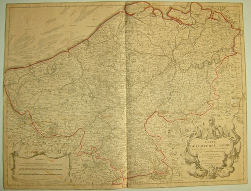
De L`Isle (Delisle), Guillaume:
Carte du Comte de Flandre. Dressée sur differens morceaux levez sur les lieux fixéz par les Observations Astronomiques. Altkolorierte Kupferstichkarte.
48,5 x 65 cm (Blattgröße ca. 54,5 x 80 cm). *Frühe Delisle-Karte, zeigt Belgien. - Guillaume Delisle (1675-1726) war ein französischer Kartograph aus Paris. Delisle war der erste, der eine wissenschaftlich vergleichende Geographie anbahnte, indem er bei seinen Werken auch Reiseberichte und die Werke von Naturforschern benutzte. Er gab zahlreiche Landkarten heraus, die sich durch Eleganz und Schärfe von den früheren Karten unterschieden. - Der breite weiße Rand wurde zeitgenössisch eigens aufmontiert, vermutlich wegen der enormen Blattgröße. Sauber und gut erhalten. / Early print of this Delisle map. The large white edges were mounted separate in contemporarily time (probably because of the enormous sheet size). Very good condition. Landkarten de
|
|
|
De L`Isle (Delisle), Guillaume:
Carte du Royaume de Danemarc. Kupferstichkarte mit Grenzkolorit.
48 x 63 cm (Blattgröße: 54,5 x 81 cm). *Frühe Delisle-Karte, zeigt Dänemark mit Holstein im Süden sowie den östlichen Inseln und Südschweden. - Guillaume Delisle (1675-1726) war ein französischer Kartograph aus Paris. Delisle war der erste, der eine wissenschaftlich vergleichende Geographie anbahnte, indem er bei seinen Werken auch Reiseberichte und die Werke von Naturforschern benutzte. Er gab zahlreiche Landkarten heraus, die sich durch Eleganz und Schärfe von den früheren Karten unterschieden. - Der breite weiße Rand wurde zeitgenössisch eigens aufmontiert, vermutlich wegen der enormen Blattgröße. Sauber und gut erhalten. / Early print of this Delisle map. The large white edges were mounted separate in contemporarily time (probably because of the large sheet size). Very good condition. Landkarten de
|
|
|
De L`Isle (Delisle), Guillaume:
Carte Particulière d`Anjou et de Touraine ou de la Partie Meridionale de la Generalite de Tours. Teilkolorierte Kupferstichkarte.
48,5 x 66 cm (Blattgröße: 54,5 x 81 cm). *Frühe Delisle-Karte, zeigt detailliert das Flussgebiet des Anjou südlich Tours in der Bretagne. - Guillaume Delisle (1675-1726) war ein französischer Kartograph aus Paris. Delisle war der erste, der eine wissenschaftlich vergleichende Geographie anbahnte, indem er bei seinen Werken auch Reiseberichte und die Werke von Naturforschern benutzte. Er gab zahlreiche Landkarten heraus, die sich durch Eleganz und Schärfe von den früheren Karten unterschieden. - Der breite weiße Rand wurde zeitgenössisch eigens aufmontiert. Sauber und sehr gut erhalten. / Early print of this Delisle map. The large white edges were mounted separate in contemporarily time. Good condition. Landkarten de
|
|
|
De L`Isle (Delisle), Guillaume:
La France. Dressée sur un grand nombre de Cartes particulieres manuscrites ou imprimée levées sur les lieux. Teilkolorierte Kupferstichkarte.
49 x 67 cm (Blattgröße: 54,5 x 81 cm). *Frühe Delisle-Karte, zeigt detailliert das gesamte Frankreich. Große Titelkartusche unten links. - Guillaume Delisle (1675-1726) war ein französischer Kartograph aus Paris. Delisle war der erste, der eine wissenschaftlich vergleichende Geographie anbahnte, indem er bei seinen Werken auch Reiseberichte und die Werke von Naturforschern benutzte. Er gab zahlreiche Landkarten heraus, die sich durch Eleganz und Schärfe von den früheren Karten unterschieden. - Der breite weiße Rand wurde zeitgenössisch eigens aufmontiert. Linker Außenrand mit kleinem Tintenfleckchen, insgesamt sauber und gut erhalten. / Early print of this Delisle map. The large white edges were mounted separate in contemporarily time. Good condition. Landkarten de
|
|
|
De L`Isle (Delisle), Guillaume:
Partie Septentrionale De La Souabe. Par Guillaume De l`Isle Geographe de L`Academie Royale des Sciences. Altkolorierte Kupferstichkarte.
47,5 x 63,5 cm (Blattgröße: 55 x 81 cm). *Frühe Delisle-Karte, zeigt das nordwestliche Württemberg und Mittelfranken von Stuttgart bis Nürnberg in der West-Ost-Erstreckung und von Winsheim bis Göppingen in der Nord-Süd-Erstreckung. - Guillaume Delisle (1675-1726) war ein französischer Kartograph aus Paris. Delisle war der erste, der eine wissenschaftlich vergleichende Geographie anbahnte, indem er bei seinen Werken auch Reiseberichte und die Werke von Naturforschern benutzte. Er gab zahlreiche Landkarten heraus, die sich durch Eleganz und Schärfe von den früheren Karten unterschieden. - Der breite weiße Rand wurde zeitgenössisch eigens aufmontiert, vermutlich wegen der enormen Blattgröße. Sauber und gut erhalten. / Early print of this Delisle map. The large white edges were mounted separate in contemporarily time (probably because of the enormous sheet size). Very good condition. Landkarten de
|
|
|
DE LA FOSSE, J. B. ingénieur géographe
Carte de France divisée en ses Provinces et Gouvernement militaires avec toutes les Principales Routes du Royaume et Assujettie aux Observations de Mrs de l'Académie des Sciences.
1 très grande carte dépliante au format 132 x 100,5 cm (en 4 feuilles jointes), frontières des provinces coloriées, portraits des rois de France gravés sur les marges verticales, Chez l'Auteur, Paris, 1776 Belle et très grande carte de France, imprimée en 4 feuilles réunies et rehaussées en couleurs à l'époque (infime fente en pliure centrale, fente avec très petit accroc sans manque sur pliure en queue, petites piqûres d'aiguille en coins). Rare. Français

|
|
|
DE LA SOMME A LA MER
Carte Taride au 1/200 000?. Sans date.
Une feuille 50x84 cm repli?e en pochette.
|
|
|
DE ROSSI Giuseppe (Roma 1560 - 1639)
(Emisfero Orientale)
Foglio contenente sei fusi del Globo Terrestre, edito da Giuseppe de Rossi a Roma nel 1615.Il foglio costituisce la metà, raffigurante l'emisfero orientale, del celebre ed importante Globo Terrestre della tipografia De Rossi, replica italiana del più famoso globo di Jodocus Hondius, stampato ad Amsterdam nel 1601. La carta si estende dalle isole dell'Atlantico alle Indie Orientali, comprendendo le isole di Giappone (parzialmente tagliato) e Corea (qui appunto rappresentata come isola).Il solo set completo di gore di globo del de Rossi è oggi conservato alla Libray of Congress di Washington (https://www.loc.gov/item/2008627640/), mentre il solo foglio che contiene le gore qui mancanti, che coprono l'emisfero occidentale, è conservato al Marietim Museum di Rotterdam (WAE840).Sono invece noti alcuni esemplari del globo montati, tra cui quello della collezione Schmidt di Vienna, e quello del Maritime Museum di Greenwich.La peculiarità assoluta del nostro esemplare sta nel fatto che riporta in calce un imprint sconosciuto alla letteratura, Dominicus de Rubeis formis Romae ad Templum S. Marie de Pace. Domenico de Rossi, figlio o nipote di Giuseppe, è attivo a Roma nella seconda metà del XVII secolo. Fiorini (1899) descrive di Domenico de Rossi la sola ristampa del globo di Mattheus Greuter (1638) datata al 1695. Il globo terrestre di Giuseppe de Rossi – uno dei primi stampati in Italia – è una replica molto accurata dell’esemplare realizzato ad Amsterdam nel 1601 da Jodocus Hondius. Giuseppe de Rossi utilizzò le mappe di Hondius, apprezzate per la loro qualità, ma il globo è interamente realizzato in Italia e dedicato a un nobiluomo romano, come possiamo vedere dal cartiglio sul globo stesso: Ill.mo viro optimarumque artium amatori et Fautori D Paulo Mellino Romano Iosephus de Rubeis Mediolanensis devoti animi monumentum dat dicatque.Il cartiglio con dedica rivela anche la firma dell’artista e chiarifica le sue origini: Giuseppe infatti era conosciuto nella Roma dell’inizio del Seicento quale membro della nota famiglia de Rossi, già famosa a Milano per le sue stampe e mappe.Il globo presenta un secondo ampio cartiglio – nell’Oceano Pacifico – con le spiegazioni di Hondius e la data in cui è stato stampato in Italia: I[odocus] Hondius Lectori S[alutem]. In locorum longitudine hactenus mirifice peccatum esse omnibus hydrographiae peritis satis superque constat [...] Longitudinem incepimus non ab insulis fortunatis, ut Ptolemeus, sed ab ijs quae Açores vocantur, quod acus nautica ibi recte in Septentrionem vergat. Vale. Anno 1615.Un terzo cartiglio a sud dello Stretto di Magellano ci fa comprendere le conoscenze geografiche degli inizi del XVII secolo: TERRA AUSTRALIS NONDUM COGNITA (terra non ancora conosciuta).Foglio di estrema rarità.Bibliografia: Fiorini, Sfere Celesti e Terrestri di Autore Italiano, Roma 1899, pp. 271-272, 293, 369; E. L. Stevenson, Terrestrial and Celestial Globes, New Haven 1921, vol II, p. 13; P. van der Krogt, Globi Neerlandici, Utrecht 1993; The World In Your Hands. An Exhibition of Globes and Planetaria, exhibition’s catalogue of Christies Great Room in London and Museum Boerhaave in Leiden, 1995, p.42, n° 4.11; Sfere del cielo sfere della terra, exhibition’s catalogue edited by M. Milansei & R. Schmidt, Correr Museum, Venice 2007, pp. 50 and 59; Dekker, E. Globes at Greenwich (Oxford, 1999), pp. 357-9 & 482-4. Engraved plate showing 6 globe gores published by Giuseppe de Rossi in 1615, covering the Eastern Hemisphere, extended from Atlantic Ocena to the Far East. Including the Japan and Korea, here depicted as an insula (Corea ins.).This is the half set of the globe gores by Giuseppe de Rossi, known complete only for the example of the Library of Congress, while the sheet with the Western Hemisphere is preserved in the Maritiem Museum of Rotterdam. (WAE840).The peculiarity of our example is the imprint Dominicus de Rubeis formis Romae ad Templum S. Marie de Pace, not know in the literature. Domenico was the son or nephew of Giuseppe, active in Rome in the second half of 17th century.Fiorini (1899) listed by Domenico de Rossi only the late issue of the globe gores by Mattheus Greuter (1638).The terrestrial globe by Giuseppe de Rossi – one of the first printed in Italy – is a very accurate replica of the one made in Amsterdam in 1601 by Jodocus Hondius, who realized just few very detailed globes. Giuseppe de Rossi uses Hondius maps, appreciated for their quality, but the globe is entirely created in Italy and dedicated to a Roman nobleman, as we can see in the cartouche on the globe itself: Ill.mo viro optimarumque / artium amatori et Fau- / tori D Paulo Mellino Roma- / no Iosephus de Rubeis Mediolanensis devoti / animi monu- / mentum dat / dicatque. The cartouche with dedication includes also the artist’s signature and explains his origin: Giuseppe was renowned in Rome in early 17th century as a member of the well-known de Rossi family, already famous in Milan for its prints and maps.The globe bears a second large cartouche – in the Pacific Ocean – with the Hondius’ explanation and the date in which it has been printed in Italy: I[odocus] Hondius Lectori S[alutem]. / In locorum longitudine hactenus mirifice peccatum esse omnibus hydrographiae peritis satis / superque constat [...] Longitudinem / incepimus non ab insulis fortunatis, ut Ptolemeus, sed ab / ijs quae Açores vocantur, quod acus nautica ibi recte in Se- / ptentrionem vergat. Vale. / Anno 1615.A third cartouche under the Strait of Magellan let us understand the geographical knowledges of the early 17th century: TERRA AUSTRALIS NONDUM COGNITA.Very similar examples are housed at Correr Museum in Venice and in the Rudolf Schmidt’s Collection.Literature Fiorini, Sfere Celesti e Terrestri di Autore Italiano, Roma 1899, pp. 271-272, 293, 369; E. L. Stevenson, Terrestrial and Celestial Globes, New Haven 1921, vol II, p. 13; P. van der Krogt, Globi Neerlandici, Utrecht 1993; The World In Your Hands. An Exhibition of Globes and Planetaria, exhibition’s catalogue of Christies Great Room in London and Museum Boerhaave in Leiden, 1995, p.42, n° 4.11; Sfere del cielo sfere della terra, exhibition’s catalogue edited by M. Milansei & R. Schmidt, Correr Museum, Venice 2007, pp. 50 and 59; Dekker, E. Globes at Greenwich (Oxford, 1999), pp. 357-9 & 482-4.

|
|
|
De Simencourt
CARTE ITINERAIRE COMPLETE DE LA FRANCE Indiquant Les Routes Royales Avec Leur Continuation Jusque Dans Les Pays Limitrophes . Relais Et Bureaux De Poste Eaux Minerales Rivieres Et Canaux Navigables.
Paris: A. Logerot 1844. A fine map hand-coloured in outline sectioned linen-backed in original slip-case with title label to the outside slip-case worn and rubbed and cracked along some joints The map measures 96 x 66cm. In very good condition with the paper bright A fine copy of this rare map. Map. Fine. A. Logerot Hardcover
Referenz des Buchhändlers : 009581

|
|
|
De Weerd Major HA. Laim Dunne maps H. A.
Great Soldiers of World War II
W.W.Norton & Company c1944. Hardbound. VERY GOOD / Poor dj. Tight faintest age tanning of pages clean square.Slight softening and wear of spine ends and owner's name inside cover. Dust jacket is present but clipped age soiled worn at hinges and missing chunks at top and bottom edges. Chapters on: Gamelin de Gaulle Wavell Rommel Montgomery Hitler Churchill Timoshenko MacArthur Chiang Kai-Shek and Eisenhower. "A WARTIME BOOK" notice printed on back of title page. 320 indexed pages including Bibliography 40 contemporary black and white photos and 12 maps and charts Western Front Battle of Flanders and Battle of France Libyan Campaign Ethopian CampaignTobruk2 El Alamein Wareth and Wadi Akarit Moscow SW Pacific North Africa2. W.W.Norton & Company hardcover
Referenz des Buchhändlers : 1DT035
|
|
|
de Wilde John C.;Popper David H. & Clark Eunice Pictorial Charts by Irving Geis & Maps by Richard Ely Falconer
Handbook of the War
Boston MA: Houghton Mifflin Co. 1939. First Edition. Hardcover. Very Good. Size=Large 8vo. Data Tables/Charts & Maps. full book description Houghton Mifflin Co. Boston MA 1939. 1st Edition VG Hard Cover No Dust Jacket. Size=Large 8vo 248ppIndex. Data Tables/Charts & Maps. A few foxing specklesfrom dust on top page ends o.w. clean & tight. NO ink names etc. WWII-Europe; Statistical Data SELLING WORLDWIDE SINCE 1987. WE ALWAYS PACK WITH GREAT CARE! Houghton Mifflin Co. hardcover
Referenz des Buchhändlers : CONROY066342I
|
|
|
Deacon, George Edward Raven (Hrsg.)
Die Meere der Welt. Ihre Eroberungen, ihre Geheimnisse. Deutsche Bearbeitung: Günter Dietrich
Stuttgart: Chr. Belser, 1963. 1. Aufl., 297 S. mit zahlreichen Abbildungen und Karten, gebunden, Orig.-Leinen mit Deckelvignette,
Referenz des Buchhändlers : 44912

|
|
|
Deacon, George Edward Raven [Hrsg.]
Die Meere der Welt. Ihre Eroberung, ihre Geheimnisse. Herausgegeber: George E. R. Deacon. Deutsche Bearbeitung: Günter Dietrich.
Stuttgart : Belser, 1963. 1. Aufl., 297 S. mit zahlreichen Abbildungen (z.T. farb.) ; 29 cm, gebunden, Orig.-Leinen mit Orig.-Schutzumschlag,
Referenz des Buchhändlers : 49258

|
|
|
DECARIS (Albert).
[ÎLE de la CITÉ] [Le Pont Neuf et l'Île de la Cité].
[1950]. 645 x 495 mm.
Referenz des Buchhändlers : LBW-8449

|
|
|
DEFOSSEUX (Joachim) & DELARUELLE (Louis Joseph). MANUSCRIT.
[Plan d'une propriété à Lambersart].
1748. 420 x 551 mm, encadrement sous verre moderne.
Referenz des Buchhändlers : LBW-4170

|
|
|
DEFOE (Daniel)
La vie et les aventures surpernantes de Robinson Crusoé contenant son retour dans son île & les nouveaux voyages, le tout écrit par lui-même. Traduit de l'anglais. Illustré de gravures et cartes dépliantes hors texte. Contient les réflexion sérieuses et importantes de Robinson Crusoe faites pendant les avantures surprenantes de sa vie avec sa vision du monde angélique.
A Amsterdam chez l'Honoré et Châtelain 1720-1721. 3 bons volumes reliés, reliures plein parchemin d'époque, forts in-12, XII + 629 pages + planches, VIII + 588 pages + planches et XXXIV + 632 pages + planches. Reliure usagée du vol. 1, manque de la page de titre et traces d'usage ; sinon minimes défauts.
Referenz des Buchhändlers : AUB-5483
|
|
|
DEFOSSEZ L.
Les cartes géographiques et leurs projections usuelles. Actualités scientifiques.
Paris, Gauthier-Villars, 1910. "12 x 19, 119 pp., 2 planches dépliantes, 21 figures, broché, bon état (dos légèrement recollé; cachet d'ex-propriétaire)."
Referenz des Buchhändlers : 91151
|
|
|
Dejollier, Rene.
pensee de Namur.
S.l., Wesmael-Charlier, 1980 Broche, couvert. illustr., 166pp., 20x27cm., ills. en n/b., bon etat, dos peu ambime.
Referenz des Buchhändlers : 29950
|
|
|
DELAFOSSE (Jean-Baptiste).
[ANJOU & TOURAINE] Carte des provinces d'Anjou et de Touraine dressée suivant les nouvelles observations de M.rs de l'Accadémie Royale des Sciences. Par J.B. Delafosse.
1780. 511 x 720 mm ; repliée sous couverture cartonnée recouverte de papier bleu de l'époque (200 x 126 mm) ; étiquette sur le premier plat portant le titre manuscrit à l'encre.
Referenz des Buchhändlers : LBW-8432

|
|
|
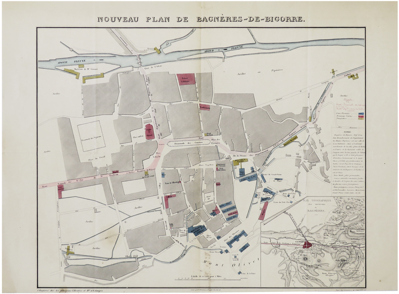
DELAMARE (F.).
[BAGNÈRES-de-BIGORRE] Nouveau plan de Bagnères-de-Bigorre.
Bagnères, chez les principaux Libraires et M.ds d'Estampes, [circa 1850]. 425 x 498 mm.
Referenz des Buchhändlers : LBW-7416
|
|
|
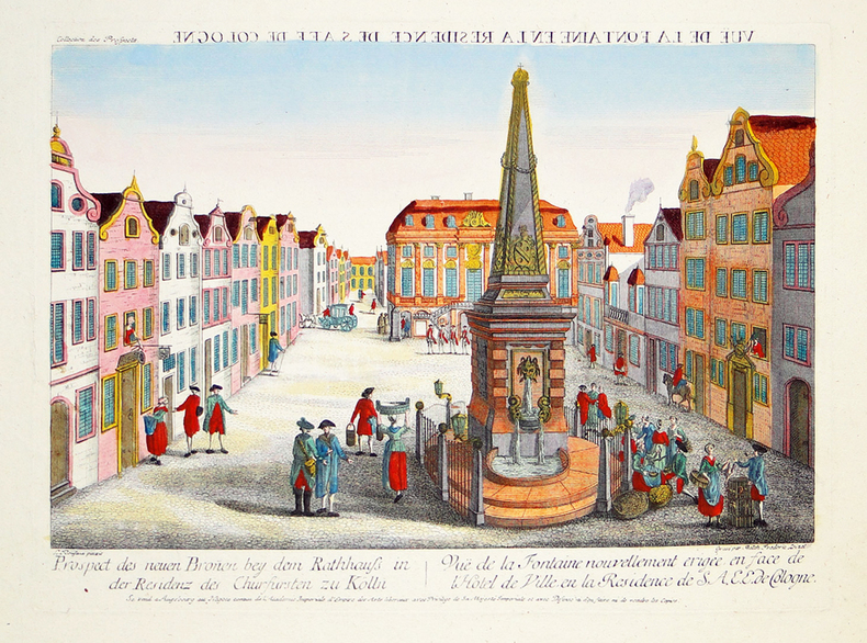
DELSENBACH (Johann Adam) & LEIZELT (Balthasar Friedrich).
[BONN] Vuë de la fontaine en la résidence de S.A.E.E. de Cologne.
Augsbourg, Négoce commun de l'Académie Impériale d'Empire des Arts Libéraux, [circa 1780]. 295 x 395 mm.
Referenz des Buchhändlers : LBW-2791
|
|
|
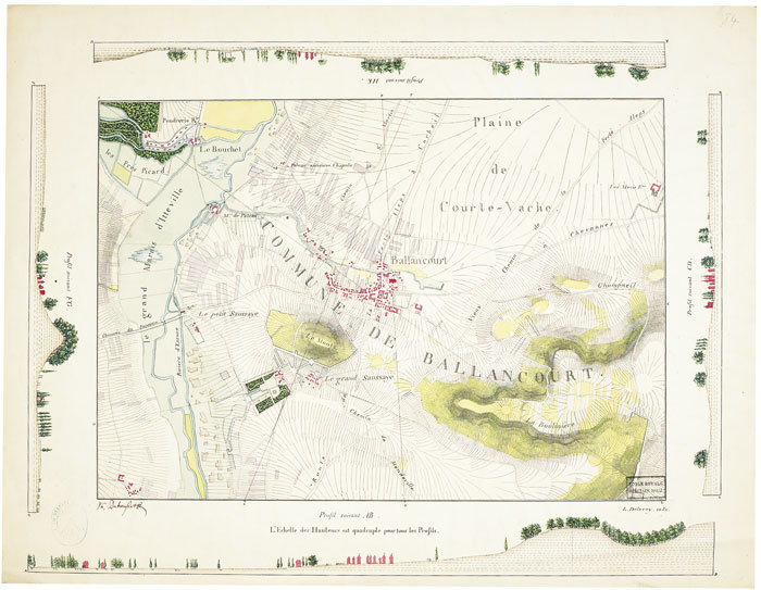
DELÉCEY de CHANGEY (Louis-Charles). MANUSCRIT.
[Carte de la région de Ballancourt-sur-Essonne].
1826. 421 x 546 mm.
Referenz des Buchhändlers : LBW-549
|
|
|
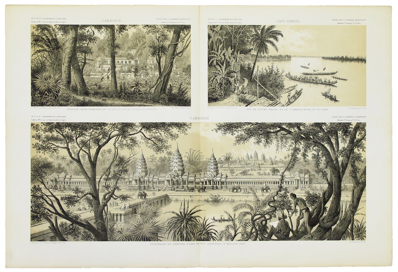
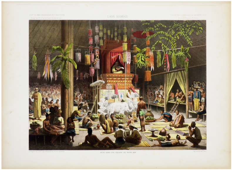
DELAPORTE (Louis) & GARNIER (Francis).
[CAMBODGE/ANGKOR] Colonnade de l'entrée ouest et vue générale d'Angcor Wat - Angcor Thom : Phimanacas (ruines du palais des rois d'Angcor) - Vue de Stunc Trenc et de l'embouchure du Se Cong.
Paris, [1873]. 433 x 639 mm.
Referenz des Buchhändlers : LBW-4908
|
|
|
DELAGRIVE (Jean, abbé).
[COUR des AIDES] Carte des jurisdictions ressortissantes en la Cour des Aydes de Paris. Élections, greniers à sel, juges des traites foraines, des dépôts des sels et de la marque des fers et prévôtés du Clermontois.
1747. 520 x 684 mm.
Referenz des Buchhändlers : LBW-8197

|
|
|
DELAFOSSE (Jean-Baptiste).
[DANEMARK] Carte du royaume de Danemarck divisé en ses différents états.
Paris, Mondhare, 1780. 514 x 626 mm.
Referenz des Buchhändlers : LBW-5245

|
|
|
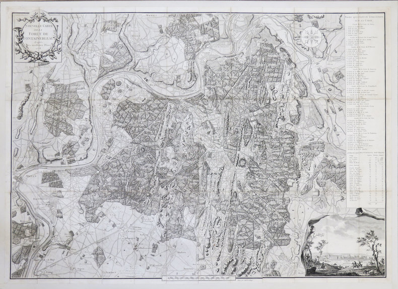
DELAHAYE (Guillaume-Nicolas).
[FORÊT de FONTAINEBLEAU] Nouvelle Carte de la forêt de Fontainebleau d'après les meilleurs plans.
1778. En 36 sections jointes et montées sur toile de 592 x 827 mm.
Referenz des Buchhändlers : LBW-3554
|
|
|
DELAFOSSE (Denis ?).
[FRANCHE-COMTÉ] Carte du gouvernement général du Comté de Bourgogne ou Franche-Comté divisée en baillages et territoires. Assujétie aux observations astronomiques et aux opérations trigonométriques de Messieurs de l'Académie Royale des Sciences. Dressée et gravée par D.s Delafosse Géog.e.
Paris, le S. Daumont, 1761. 685 x 493 mm ; repliée sous couverture cartonnée recouverte de papier bleu de l'époque (195 x 125 mm) ; étiquette sur le premier plat portant le titre manuscrit à l'encre.
Referenz des Buchhändlers : LBW-8447

|
|
|
DELESSE (Achille).
[HYDROLOGIE] Carte hydrologique de la ville de Paris.
Paris, F. Savy, 1858. En 18 sections montées sur toile et pliées, formant un plan de 0,96 x 1,33 m ; sous étui en percaline noire de l'époque avec titre en lettres dorées au dos.
Referenz des Buchhändlers : LBW-6122

|
|
|
DELAPORTE (Louis) & GARNIER (Francis).
[LAOS] Laos siamois. Fête dans une pagode de Nong Kay.
[Paris, 1873]. 296 x 382 mm.
Referenz des Buchhändlers : LBW-2764
|
|
|
DELAFOSSE (Denis ?).
[MAINE & PERCHE] Carte du gouvernement général du Maine et Perche.
Paris, Basset, 1773. 495 x 700 mm ; repliée sous couverture cartonnée recouverte de papier saumon de l'époque (201 x 125 mm) ; étiquette sur le premier plat portant le titre manuscrit à l'encre.
Referenz des Buchhändlers : LBW-8459

|
|
|
DELAFOSSE (Denis ?).
[NIVERNAIS] Duché et gouvernement général de Nivernois.
Paris, Daumont, 1760. 493 x 617 mm ; repliée sous couverture cartonnée recouverte de papier bleu de l'époque (200 x 127 mm) ; étiquette sur le premier plat portant le titre manuscrit à l'encre.
Referenz des Buchhändlers : LBW-8450

|
|
|
DELSENBACH (Johann Adam) & LEIZELT (Balthasar Friedrich).
[NUREMBERG] Façade de l'église de S. Laurent à Nuremberg.
Augsbourg, Négoce commun de l'Académie Impériale d'Empire des Arts Libéraux, [circa 1780]. 295 x 395 mm.
Referenz des Buchhändlers : LBW-2790

|
|
|
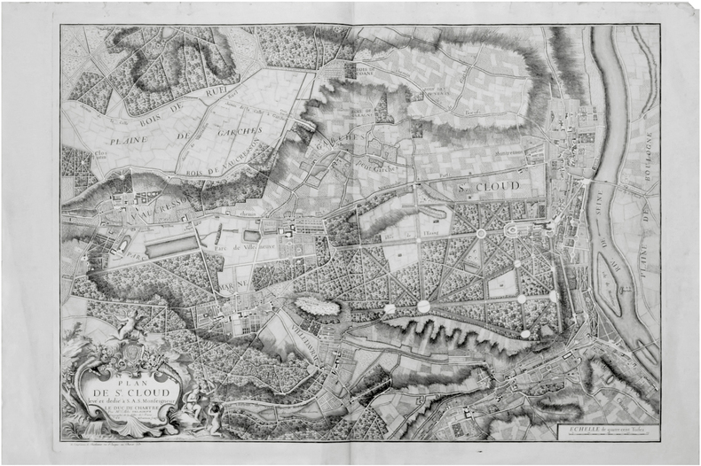
DELAGRIVE (Jean, abbé).
[SAINT-CLOUD] Plan de St. Cloud levé et dédié à S.A.S. Monseigneur le duc de Chartre.
Paris, Charbonnier, 1744. 595 x 845 mm.
Referenz des Buchhändlers : LBW-7309
|
|
|
DELAROCHE-PONCIÉ (Ferdinand-Antoine-Jules).
[SAINT-PIERRE-et-MIQUELON] Plan de l'île S.t Pierre (côte méridionale de Terre-Neuve).
[Paris], Dépôt-Général de la Marine, 1843. 880 x 589 mm.
Referenz des Buchhändlers : LBW-8309

|
|
|
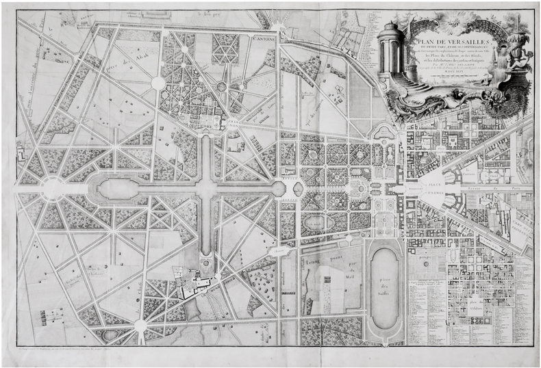
DELAGRIVE (Jean, abbé).
[VERSAILLES] Plan de Versailles, du Petit Parc, et de ses dépendances où sont marqués les emplacemens de chaque maison de cette ville, les plans du château, et des hôtels, et les distributions des jardins et bosquets.
Paris, Fourneau, 1746. 607 x 921 mm.
Referenz des Buchhändlers : LBW-7308
|
|
|
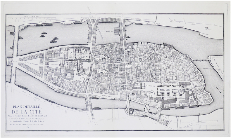
DELAGRIVE (Jean, abbé).
[ÎLE de la CITÉ] Plan détaillé de la Cité.
Paris, [1754]. 475 x 810 mm ; sur papier fort, doublé d'un papier Japon.
Referenz des Buchhändlers : LBW-7848
|
|
|
Delamarre, Mariel Jean-Brunhes - Deffontaines, Pierre Cartes de Jacques Bertin -
Atlas Aérien - France - Tome II - Bretagne - Val de Loire - Sologne et Berry - Entre Loire et Gironde
PARIS, N.R.F./Editions Gallimard , 1957 - In-4 - Reliure pleine toile sous jaquette illustrée (accroc) - 192 pages , 268 photographies et 3 cartes en noir et blanc - bon exemplaire - Envoi rapide et soigné
Referenz des Buchhändlers : 27386
|
|
|
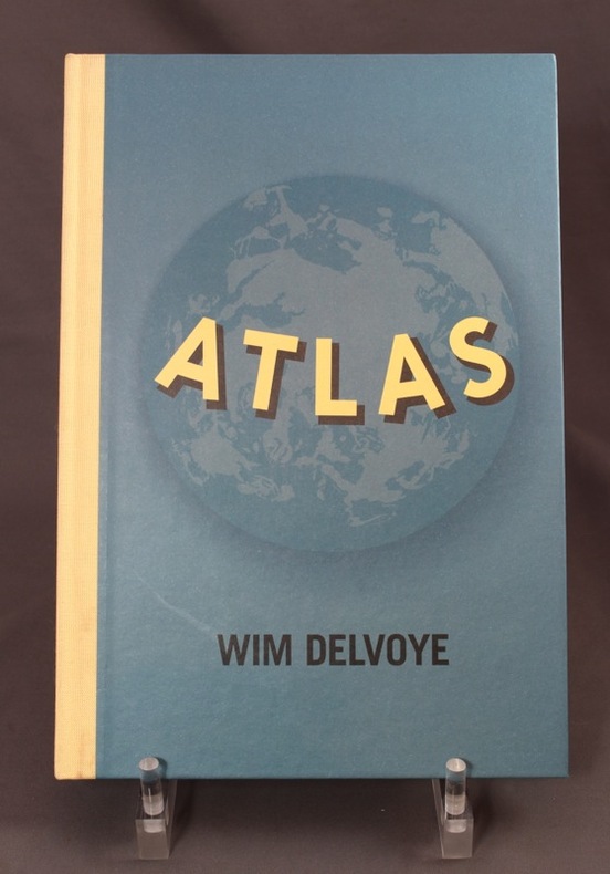
DELVOYE Wim; TADDEI J.-F.; VAN DEN ABEELE L.:
Atlas.
Nantes, Fonds régional d'art contemporain des Pays-de-la-Loire, Michel Baverey éditeur, 1999. In-4 non paginé, cartonnage bleu illustré d'éditeur, dos de toile écrue. A l'état de neuf.
Referenz des Buchhändlers : 7674
|
|
|
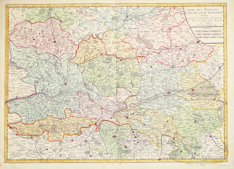
DELAFOSSE (Jean-Baptiste).
Carte des provinces d'Anjou et de Touraine dressée suivant les nouvelles observations de M.rs de l'Accadémie Royale des Sciences.
1780. 506 x 715 mm.
Referenz des Buchhändlers : LBW-2695
|
|
|
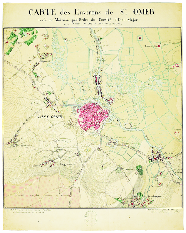
DELÉCEY de CHANGEY (Louis-Charles). MANUSCRIT.
Carte des environs de St. Omer, levée en mai 1830, par ordre du comité d’État-Major, pour l’Atlas de M.gr le duc de Bordeaux.
1830. 410 x 410 mm.
Referenz des Buchhändlers : LBW-4145
|
|
|
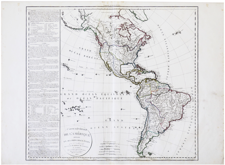
DELAMARCHE (Félix).
Carte générale de l'Amérique divisée en ses principaux états.
Paris, chez l'auteur, 1825. 548 x 600 mm + tableau de 420 x 545 mm.
Referenz des Buchhändlers : LBW-6176
|
|
|
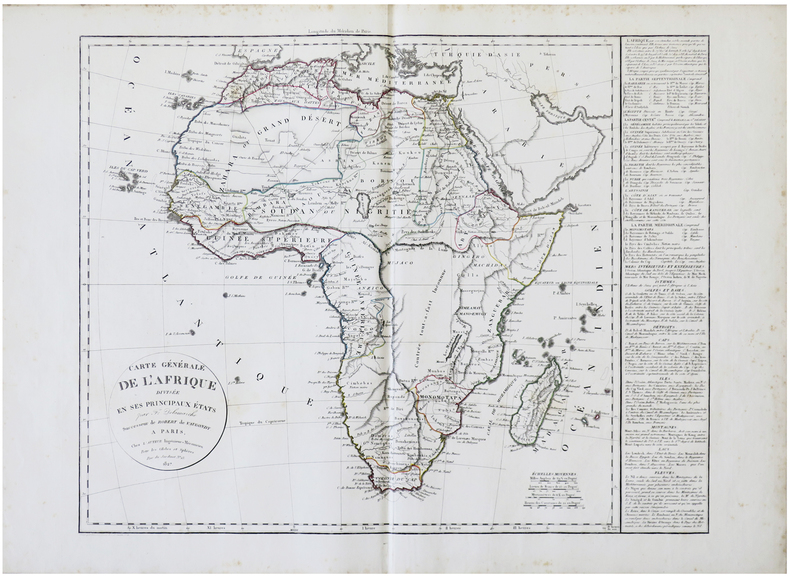
DELAMARCHE (Félix).
Carte générale de l'Afrique divisée en ses principaux états.
Paris, chez l'auteur, 1827. 503 x 627 mm + tableau de 412 x 542 mm.
Referenz des Buchhändlers : LBW-6177
|
|
|
DELAMARCHE (Félix).
Carte générale de l'Europe divisée en ses différens états.
Paris, chez l'auteur, 1828. 507 x 632 mm + tableau de 395 x 543 mm.
Referenz des Buchhändlers : LBW-6184

|
|
|
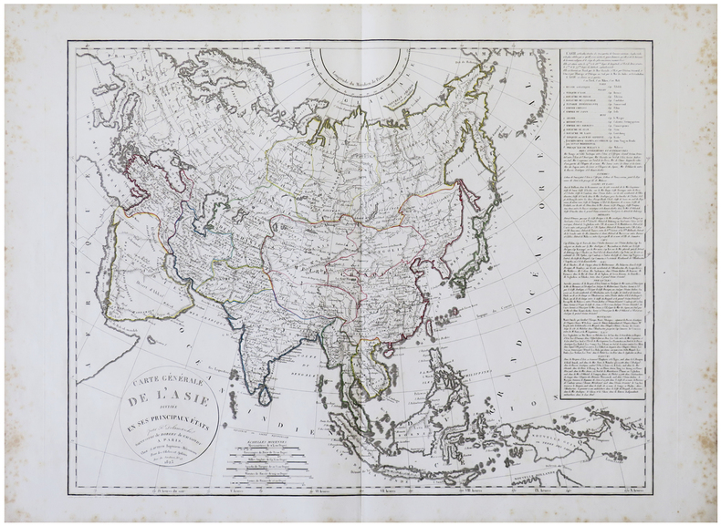
DELAMARCHE (Félix).
Carte générale de l'Asie divisée en ses principaux états.
Paris, chez l'auteur, 1825. 500 x 641 mm + tableau de 409 x 537 mm.
Referenz des Buchhändlers : LBW-6189
|
|
|
DELISLE, Guillaume ; [ De L'Isle, Guillaume ]
Carte du Comté de Flandres dressée sur differens morceaux levez sur les lieux fixéz par les Observations Astronomiques.
carte au format 645 x 49 cm., frontières rehaussée en couleur, par Guillaume De l'Isle, de l'Académie Royale des Sciences à Paris, Chez l'Auteur sur le Quai de l'Horloge, 1704
Referenz des Buchhändlers : 26466
|
|
|
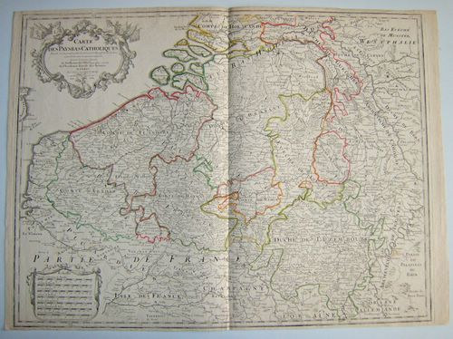
DELISLE, Guillaume ; [ De L'Isle, Guillaume ]
Carte des Pays Bas Catholiques dressée sur un grand nombre de cartes particulières faites sur les lieux où les limites sont exactement marquées, suivant les derniers Traitéz
Carte au format 66 x 48 cm, frontières rehaussée en couleur, par Guillaume De l'Isle, de l'Académie Royale des Sciences à Paris, Chez l'Auteur sur le Quai de l'Horloge, 1702
Referenz des Buchhändlers : 26467
|
|
|
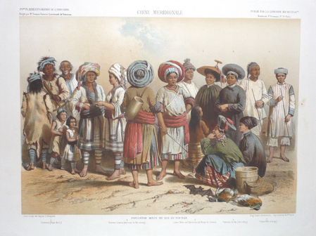
DELAPORTE (Louis) & GARNIER (Francis).
Chine méridionale. Population mixte du sud du Yun-Nan.
Paris, [1873]. 273 x 385 mm.
Referenz des Buchhändlers : LBW027b5
|
|
|
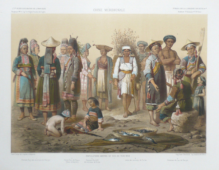
DELAPORTE (Louis) & GARNIER (Francis).
Chine méridionale. Populations mixtes du sud du Yun-Nan.
Paris, [1873]. 290 x 382 mm.
Referenz des Buchhändlers : LBW061c3
|
|
 Per e-mail erhalten
 Als pdf-Dokument herunterladen
 RSS feed


