|
|
|
David Watson Maps by Rosemary Watson
Family-Friendly Walks Cartmel Peninsula. Map Guide
Sheet map. As New. unknown
书商的参考编号 : ria9780956521873_rkm ???????? : 0956521878 9780956521873

|
|
|
David Watson Maps by Rosemary Watson
Walks from the Keswick Launch. Map Guide
Sheet map. New. unknown
书商的参考编号 : ria9780956521859_new ???????? : 0956521851 9780956521859
|
|
|
David Watson Maps by Rosemary Watson
Walks from the Keswick Launch. Map Guide
Sheet map. As New. unknown
书商的参考编号 : ria9780956521859_rkm ???????? : 0956521851 9780956521859
|
|
|
David, Joy (editor)
The Hidden Places of North Yorkshire
No marks or inscriptions to contents. No creasing to front cover or to spine, small crease to lower corner of rear cover. A very clean very tight copy with bright boards, slight damp effect to part of rear fore-edge and no bumping to corners. Fold-out map at rear in excellent condition. 216pp. An easily used book which takes you on a gentle meander through the beautiful countryside of North Yorkshire. As well as some of the well-known tourist attractions are those little known features which are so easily missed.

|
|
|
Davidson B.; photos maps drawings Illustrator
THE LOST CITIES OF AFRICA K4
Little Brown and Company 1959-01-01. Paperback. Very Good. Little, Brown and Company paperback
书商的参考编号 : 200605031
|
|
|
Davidson, Marshall B. and McTigue, Bernard.
TREASURES OF THE NEW YORK PUBLIC LIBRARY.
304 p. Numerous photographic illustrations by Jonathan Wallen. 4to. Original full cloth binding. Dust jacket. First Edition. Published at $60.00. Fascinating tour through the collections of one of the greatest American libraries. The New York Public Library houses more than 8 million volumes, 23 million manuscripts and half a million recordings. Includes: Washington's Farewell Address; the first Gutenberg B ible ever brought to this hemisphere; rare globes and maps; musical scores; and much more. A lavish history. **PRICE JUST REDUCED! REF1
|
|
|
Davis Burke/Palacios Rafael D. maps
Jeb Stuart: The Last Cavalier
NY: Rinehart & Co. 1957. 1st printing. VG/no dust jacket gift inscription on front endpaper. 14 462 p. photos maps notes biblio index 8vo; Rinehart & Co. hardcover
书商的参考编号 : 53858

|
|
|
DAVIS Julia; Frederic Taubes illus.; George Annand maps
Rivers of America: The Shenandoah
New York: Farrar & Rinehart 1945. First Edition. Octavo 20.5cm; bright blue cloth stamped in gilt on spine with darker blue label; blue and yellow pictorial dustwrapper; pictorial pastedowns; 374pp. Dustwrapper soiled; chips and small tears along extremities; material loss at crown and heel of spine; mild soiling to textblock edge else interiors clean and sound. Very Good or Better in Very Good dustwrapper. Gift label tipped to front pastedown. The enduring Rivers of America series is noted for taking a more artistic approach to the individual histories of America's rivers. This book is Julia Davis's testimony of the Shenandoah River the people who settled in its valley and the wars fought along its banks. Of particular interest to today's local historians may be the three literary Valley Tours which lend an authentic WWII-era perspective on the area and local attitudes particularly towards industrial development e.g. American Viscose and race relations e.g. Storer College. With b/w text-illustrations throughout. Printed on lower quality "Wartime" stock. Farrar & Rinehart unknown
书商的参考编号 : 46981

|
|
|
Davis William C.; Maps 46 Illus & 8
Battle At Bull Run A History of the First Major Campaign of the Civil War
Norwalk CT: Easton Press. Fine with no dust jacket. 1996. Full Leather. Fine full leather edition no names or other marks. ; 8vo 8" - 9" tall; 298 pages . Easton Press hardcover
书商的参考编号 : 23672

|
|
|
Davison, Brian K.
The Observer's Book of Castles
185 pages. Most people are attracted by the brooding majesty or picturesque ruins of castles. This work provides a wealth of detailed information about them, often illustrated by fascinating historical anecdotes. With 46 line drawings, 12 black and white illustrations and 3 maps. Dust jacket bright with light wear and price clipped. Book
|
|
|
Dawson Robert K. maps"
Collection of 18 English County Maps Plus Reports for Cumberland Lancashire Leicestershire Norfolk Northamptonshire Northumberland Nottinghamshire Shropshire Somersetshire Staffordshire & Suffolk"
collection of 18 hand coloured folding maps including Derbyshire Devonshire Durham Essex Hampshire Kent Lancashire Leicestershire Norfolk Northamptonshire Northumberland Nottinghamshire Shropshire Somersetshire Staffordshire Suffolk Surrey & Sussex each are by Robert K. Dawson 1798‱861 - an English surveyor and cartographer. Plus reports from some of the counties reports signed L. B. Allen or J. G. S. Lefevre" hardcover
书商的参考编号 : 61842
|
|
|
Dawson (Tom & Judy)
The Hochman Encyclopedia of American Playing Cards.
STAMFORD U.S. Games Systems 2000 Un volume in-4°, 324 pp., couverture illustrée en couleurs. (couverture un peu voilée). Ouvrage de référence sur la carte à jouer américaine abondamment illustrée (figures en noir, 24 planches d' illustrations en couleurs). Exemplaire enrichi d'un hommage signé des auteurs. On joint : " American playing cards PRICE GUIDE, based upon The Hochman encyclopedia of american playing cards by Tom and Judy Dawson", october 2000, U.S. GAMES SYSTEMS, Stamford, in-4°, 36 pp., agrafé.
书商的参考编号 : 023774 ???????? : 1572812990
|
|
|
Dawson George M. Geological Survey Maps.
Maps to accompany Annual Report. New Series Volume VII 1894. Geological Survey of Canada.
Ottawa: Dawson 1896. . 7 maps in a brown printed envelope. Some wear to edges of envelope maps are in fine condition. Maps are: 556. British Columbia - Kamloops Sheet - Geology / 557. British Columbia - Kamloops Sheet - Topography Economic Minerals and Glacial Striae / 567. British Columbia Finlay and Omenica Rivers / 571. Province of Quebec Montreal Sheet Eastern Township Map / 561. New Brunswick and Nova Scotia Sheet Cumberland Coal-field Sheet - Surface Geology / 562. New Brunswick Richibucto Sheet / 563. New Brunswick and Prince Edward Island Buctouche Sheet. <br/><br/> Ottawa: Dawson, 1896. unknown
书商的参考编号 : 55794

|
|
|
Dawson, Joan
The Mapmakers' Legacy: Nineteenth (19th) Century Nova Scotia Through Maps
152 pages. Bibliography. Index. Wonderfully illustrated, often in colour. Printed upon glossy stock. Handsomely produced. "Plot's Nova Scotia's growth through the careful examination and analysis of maps from the nineteenth century. An exciting time in Nova Scotia's history, this period saw the first serious attempts to gain knowledge of the entire province, its resources and its inhabitants. Traces developments in our province that today are taken for granted." - from back cover. Clean, bright and unmarked with light wear. A high-quality copy. Book

|
|
|
Day, J.H.; Farstad, L.; Laird, D.G.
Soil Survey - Southeast Vancouver Island and Gulf Islands, British Columbia
104 page softcover book plus three large colour maps entitled: Soil Map of Vancouver Island - Duncan/Nanaimo; Courtenay/Campbell; Qualicum/Alberni. Stored in slip case. Report No. 6 of the British Columbia Soil Survey 1959. Gift inscription upon front panel of slip case. Prior owner's name upon each component of contents. Average wear to maps and book. Taped tear along bottom edge of slip case which remains functional. Good working copy of this excellent reference. Book
|
|
|
de Bouman de Ryckholt, Miguel
Prentbriefkaarten: kastelen België = Cartes postales: chateaux Belgique = Post cards: castles Belgium Chateaux Belgique - Kastelen Belgie - Belgium Castles. / Cartes postales anciennes Chateaux Belgique - Prentbriefkaarten Kastelen Belgie - Postcards collection Belgium Castles. set 6 VOLUMES
, Bruxelles, Retro, edition, 1998., Plats de carton origenaux, set 6 volumes ensemble( A-Z), compleet. 21,5x 30,5cm, 208pp, 208pp, 208pp, 208pp,208pp, 208pp, illustration, cartes postales anciennes.
书商的参考编号 : 5319
|
|
|
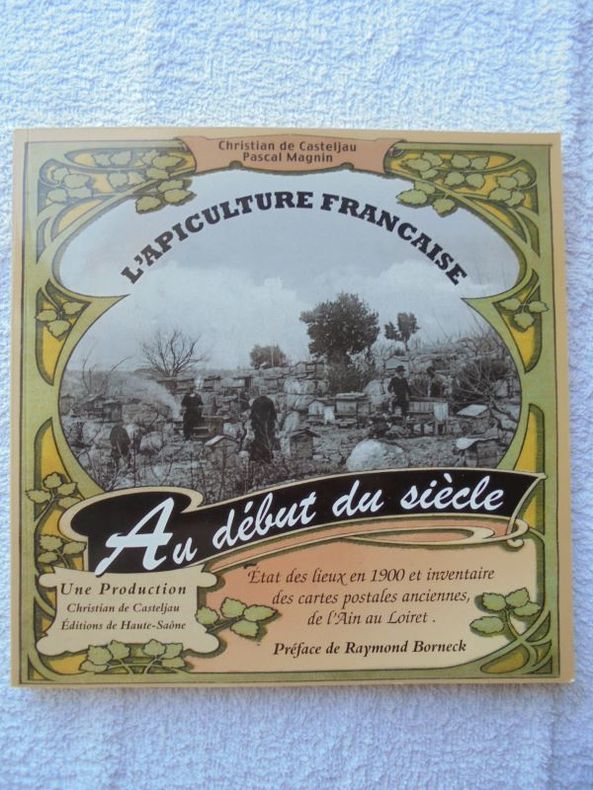
DE CASTELJAU Christian et Pascal MAGNIN.
L'apiculture française au début du siècle.
brochés - 20,5x20,5 - Editions HAUTE - SAÔNE.
书商的参考编号 : 19095
|
|
|
DE CROZAT
Manuel de géographie par demandes et par réponses.
Huitième édition augmentée du c de toutes les villes de France, avec les départements dans lesquels elles sont situées, et leurs distances de Paris en lieus de poste, du tableau des principales villes du monde avec leurs distances de la capitale, du traité de la sphère, d’un aperçu de géologie, du siège des Evêchés, cours royales, divisions militaires, de la population, des chefs lieux de préfectures, sous préfectures etc. d’un manuel de géographie ancienne, terminée par le tableau des mœurs, usages et coutumes des peuples des 5 parties du monde par M de FORIS. Cartes gravées, frontispice, titre, 444 pages A Paris chez MORONVAL 1831 in 12 demi cuir rouge, reliure muette. 1) astronomie et sphère: 9 figures en une planche. 2) carte de l’Europe. 3) cartes de l’Asie. 4) Cartes de l’Afrique- de l’Amérique septentrionale et méridionale en une planche dépliante. 5) carte de l’Océanie ou cinquième partie du monde 6) carte du monde connu des anciens. Cartes gravées par HOCQUART.
书商的参考编号 : 11966
|
|
|
DE DION-BOUTON.
Carte Routière De Dion-Bouton. Rouen.
Puteaux, De Dion-Bouton, sd. Carte entoilée de 81x95 cm, enroulée sur deux tringles de bois noirci.
书商的参考编号 : 6950
|
|
|
DE FER (Nicolas).
Dieppe. Ville de Normandie au Pais de Caux. Port de Mer. Située sur la rivière que forme les 3 ruisseaux de St Sens de NeufChastel et d'Eaulne... Elle fut bombardée par les Anglois l'An 1694.
Sans nom ni date (circa 1715). Gravure en noir mise en couleurs postérieurement, 345 x 276 mm, très bon état.
书商的参考编号 : 21651

|
|
|
DE FER (Nicolas).
Dieppe. Ville de Normandie au Pays de Caux. port de Mer Située sur la Rivière que forme les 3 Ruisseaux de St Sens de Neuf-Chastel et d'Eaulne... Elle fut Bombardée par les Anglois l'An 1694.
Sans nom ni date (circa 1702). Gravure en noir, 345 x 256 mm, très bon état.
书商的参考编号 : 21653

|
|
|
DE FER Nicolas (1646-1720 circa)
Mappe-Monde, ou Carte Generale De La Terre, Divisee En Deux Hemispheres…
Bell'esemplare della mappa murale del mondo di De Fer, pubblicata per la prima volta nel 1700. Il testo rileva che la mappa è una riduzione della mappa murale in quattro fogli del mondo dello stesso autore, pubblicata per la prima volta nel 1695. De Fer afferma che questa mappa è la prima a tenere conto delle osservazioni astronomiche della Royal Academy of Sciences. Sembrerebbe, infatti, che l'autore abbia consultato diverse fonti per meglio realizzare California, Giappone e Australia.L'Australia è mostrata come incompleta e ancora attaccata alla nuova Guinea. La Nuova Zelanda viene realizzata solo a grandi linee. Il fiume Mississippi ha la sua confluenza con il Golfo del Messico considerevolmente più ad ovest rispetto al suo vero corso. Sono inseriti molti altri nomi di luoghi e il commento scientifico è notevolmente dettagliato.Incisa da Johannes Van Loon, la mappa include vignette che mostrano tuoni, fulmini, tempeste e maree, vulcani, ecc. Le osservazioni celesti sono mostrate nella parte superiore. Acquaforte, bella coloritura coeva, in buono stato di conservazione. Rara. Nice example of De Fer's wall map of the world, first published in 1700. The text notes that the map is a reduction of De Fer's 4 sheet wall map of the world, first issued in 1695. De Fer states that this map is the first map to be prepared based upon the astronomical observations of the Royal Academy of Sciences. In fact, it would appear that different sources entirely have been consulted for California, Japan and Australia.Australia is shown as substantially incomplete and still attached to new Guinea. New Zealand appears in partial outline. The conjectural land bridge from Asia to America is still in evidence. The Mississippi River has its confluence with the Gulf of Mexico considerably west of its true course, based upon La Salle's eroneous reports. There are many more place names on this 2 sheet edition of the wall map. The scientific comentary is quite remarkable and detailed.Engraved by Van Loon, the map includes vignettes show thunder, lightening, tempests and tides, volcanoes, etc. Celestial observations are shown at the top. Etching with fine original colour, good condition. Rare. Shirley, The Mapping of the World, n. 600.

|
|
|
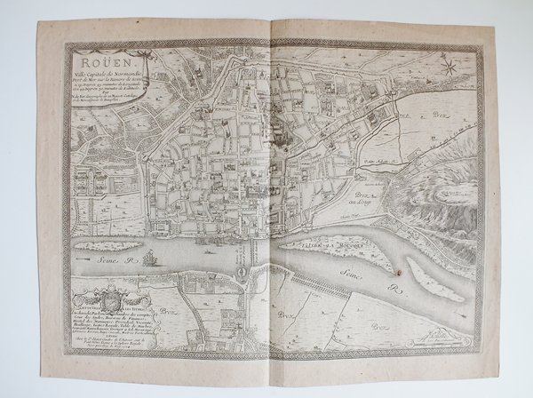
DE FER, Nicolas
Roüen Ville Capitale de Normandie [ Carte - Plan ]. A 15 degrez 45 minutes de Longitude et a 49 degrez 30 minutes de Latitude.
Carte gravée au format 60 x 46 cm, Chez le Sr Danet, Gendre de l'Auteur sur le Pont Notre Dame à la Sphère Royale, 1724, à l'échelle de 500 pas communs
书商的参考编号 : 26462
|
|
|
DE FER, Nicolas
Roüen Ville Capitale de Normandie [ Carte - Plan ]. A 15 degrez 45 minutes de Longitude et a 49 degrez 30 minutes de Latitude.
Carte gravée au format 60 x 46 cm, Chez le Sr Danet, Gendre de l'Auteur sur le Pont Notre Dame à la Sphère Royale, 1724, à l'échelle de 500 pas communs Belle carte gravée de Rouen (une très petite brûlure, bel état par ailleurs) Français

|
|
|
De Franciscis, Alfonso
Guide with Reconstructions : Pompeii Herculaneum - Past and Present
No inscriptions or marks. No creasing to covers or to spine. A very clean very firm copy with bright unmarked red pvc bevelled-edge boards and no bumping to corners. Spiral binding in excellent condition. Dust jacket not price clipped or marked or torn or creased. 90pp. This guide to this ancient city which was destroyed by the volcanic action of Vesuvius in 79 AD, is well illustrated including a large number of full page photographs of scenes as they are now with coloured acetate overlays indicating their likely appearance before the eruption.

|
|
|
De L`Isle (Delisle), Guillaume:
Carte d`Artois. Kupferstichkarte mit Grenzkolorit.
48 x 60 cm (Blattgröße: 54,5 x 81 cm). *Frühe Delisle-Karte, zeigt den Nordosten von Frankreich südlich Calais mit dem östlich angrenzenden Gebiet von Belgien. - Guillaume Delisle (1675-1726) war ein französischer Kartograph aus Paris. Delisle war der erste, der eine wissenschaftlich vergleichende Geographie anbahnte, indem er bei seinen Werken auch Reiseberichte und die Werke von Naturforschern benutzte. Er gab zahlreiche Landkarten heraus, die sich durch Eleganz und Schärfe von den früheren Karten unterschieden. - Der breite weiße Rand wurde zeitgenössisch eigens aufmontiert, vermutlich wegen der enormen Blattgröße. Sauber und gut erhalten. / Early print of this Delisle map. The large white edges were mounted separate in contemporarily time (probably because of the large sheet size). Very good condition. Landkarten de
|
|
|
De L`Isle (Delisle), Guillaume:
Carte de France. Dressée pour l`usage du Roy. Teilkolorierte Kupferstichkarte.
48,5 x 62 cm (Blattgröße: 54,5 x 80 cm). *Frühe Delisle-Karte, zeigt detailliert das gesamte Frankreich. Bereits 1703 war eine erste Frankreichkarte von Delisle erschienen, die vorliegende wurde neu gefertigt in veränderter Form und etwas kleinerem Maßstab (also in größerer Darstellung). Titelkartusche unten links. - Guillaume Delisle (1675-1726) war ein französischer Kartograph aus Paris. Delisle war der erste, der eine wissenschaftlich vergleichende Geographie anbahnte, indem er bei seinen Werken auch Reiseberichte und die Werke von Naturforschern benutzte. Er gab zahlreiche Landkarten heraus, die sich durch Eleganz und Schärfe von den früheren Karten unterschieden. - Sauber und sehr gut erhalten. / Early print of this Delisle map. Good condition. Landkarten de
|
|
|
De L`Isle (Delisle), Guillaume:
Carte de la Beau ce du Gatinois de la Sologne et Pays voisin dans la Generalité d`Orleans. Kupferstichkarte mit Grenzkolorit.
49,5 x 62 cm (Blattgröße: 54,5 x 81 cm). *Frühe Delisle-Karte, zeigt das Gebiet um die Loire, im Zentrum die Stadt Orleans. - Guillaume Delisle (1675-1726) war ein französischer Kartograph aus Paris. Delisle war der erste, der eine wissenschaftlich vergleichende Geographie anbahnte, indem er bei seinen Werken auch Reiseberichte und die Werke von Naturforschern benutzte. Er gab zahlreiche Landkarten heraus, die sich durch Eleganz und Schärfe von den früheren Karten unterschieden. - Der breite weiße Rand wurde zeitgenössisch eigens aufmontiert, vermutlich wegen der enormen Blattgröße. Sauber und gut erhalten. / Early print of this Delisle map. The large white edges were mounted separate in contemporarily time (probably because of the large sheet size). Very good condition. Landkarten de
|
|
|
De L`Isle (Delisle), Guillaume:
Carte de la Prevosté et Vicomté de Paris Dressée sur un grand nombre de Memoires particuliers. Kupferstichkarte.
49,5 x 64 cm (Blattgröße: 54,5 x 81 cm). *Frühe Delisle-Karte, zeigt das Gebiet um Paris. Unkoloriert (nur die Stadt Paris ist rot markiert). - Guillaume Delisle (1675-1726) war ein französischer Kartograph aus Paris. Delisle war der erste, der eine wissenschaftlich vergleichende Geographie anbahnte, indem er bei seinen Werken auch Reiseberichte und die Werke von Naturforschern benutzte. Er gab zahlreiche Landkarten heraus, die sich durch Eleganz und Schärfe von den früheren Karten unterschieden. - Der breite weiße Rand wurde zeitgenössisch eigens aufmontiert. Sauber und sehr gut erhalten. / Early print of this Delisle map. The large white edges were mounted separate in contemporarily time. Good condition. Landkarten de
|
|
|
De L`Isle (Delisle), Guillaume:
Carte des couronnes du Nord. Dedie au tres Puissant et tres Invincible Prince Charles XII, Roy de Suede, des Gots et des Vandales, Grand Duc de Finlande &c. Altkolorierte Kupferstichkarte.
45 x 62 cm (Blattgröße ca. 55 x 80 cm). *Frühe Delisle-Karte, zeigt das nördliche Finnland, Schweden und Norwegen. - Guillaume Delisle (1675-1726) war ein französischer Kartograph aus Paris. Delisle war der erste, der eine wissenschaftlich vergleichende Geographie anbahnte, indem er bei seinen Werken auch Reiseberichte und die Werke von Naturforschern benutzte. Er gab zahlreiche Landkarten heraus, die sich durch Eleganz und Schärfe von den früheren Karten unterschieden. - Der breite weiße Rand wurde zeitgenössisch eigens aufmontiert, vermutlich wegen der enormen Blattgröße. Sauber und gut erhalten. / Early print of this Delisle map. The large white edges were mounted separate in contemporarily time (probably because of the enormous sheet size). Very good condition. Landkarten de
|
|
|
De L`Isle (Delisle), Guillaume:
Carte du Bourdelois, du Perigord et des Provinces voisines. Teilkolorierte Kupferstichkarte mit Grenz- und Flächenkolorit.
71 x 64 cm (Blattgröße: 76 x 80,5 cm). *Frühe Delisle-Karte, eine zweite (größere) Variante unter diesem Titel (und in gleichem Maßstab). Sie ist größer als die andere Karte (nochmals aufgeklappt) und enthält den gesamten Südwesten Frankreichs. Die Karte zeigt das Gebiet des Bordeaux Weines und Perigord mit den Flußgebiet der Garonne und reicht südlich bis zur Spanischen Grenze. Es sind die Städte Bordeaux (im nördl. Teil) sowie Bayonne und Toulouse im südlichen Teil bis an die Pyrenäen enthalten. - Guillaume Delisle (1675-1726) war ein französischer Kartograph aus Paris. Delisle war der erste, der eine wissenschaftlich vergleichende Geographie anbahnte, indem er bei seinen Werken auch Reiseberichte und die Werke von Naturforschern benutzte. Er gab zahlreiche Landkarten heraus, die sich durch Eleganz und Schärfe von den früheren Karten unterschieden. - Der breite weiße Rand wurde zeitgenössisch eigens aufmontiert. Im Mittelfalz unten mit Einriß im weißen Rand. Seitliche Ränder mit Altersbräunung. Insgesamt gut erhalten. / Early print of this Delisle map. The large white edges were mounted separate in contemporarily time. A small tear in outline margin, altogether in good condition. Landkarten de
|
|
|
De L`Isle (Delisle), Guillaume:
Carte du Béarn de La Bigorre de l`Armagnac et des Pays Voisins. Kupferstichkarte mit Flächenkolorit.
48 x 63 cm (Blattgröße: 54,5 x 81 cm). *Frühe Delisle-Karte, zeigt einen Teil des französischen Westens. Die Provinzen mit Flächenkolorit, davon eine im Westen von Hand im Kolorit über den Plattenrand hinaus konturiert und koloriert. - Guillaume Delisle (1675-1726) war ein französischer Kartograph aus Paris. Delisle war der erste, der eine wissenschaftlich vergleichende Geographie anbahnte, indem er bei seinen Werken auch Reiseberichte und die Werke von Naturforschern benutzte. Er gab zahlreiche Landkarten heraus, die sich durch Eleganz und Schärfe von den früheren Karten unterschieden. - Gut erhalten. / Early print of this Delisle map. Good condition. Landkarten de
|
|
|
De L`Isle (Delisle), Guillaume:
Carte du Comte de Flandre. Dressée sur differens morceaux levez sur les lieux fixéz par les Observations Astronomiques. Altkolorierte Kupferstichkarte.
48,5 x 65 cm (Blattgröße ca. 54,5 x 80 cm). *Frühe Delisle-Karte, zeigt Belgien. - Guillaume Delisle (1675-1726) war ein französischer Kartograph aus Paris. Delisle war der erste, der eine wissenschaftlich vergleichende Geographie anbahnte, indem er bei seinen Werken auch Reiseberichte und die Werke von Naturforschern benutzte. Er gab zahlreiche Landkarten heraus, die sich durch Eleganz und Schärfe von den früheren Karten unterschieden. - Der breite weiße Rand wurde zeitgenössisch eigens aufmontiert, vermutlich wegen der enormen Blattgröße. Sauber und gut erhalten. / Early print of this Delisle map. The large white edges were mounted separate in contemporarily time (probably because of the enormous sheet size). Very good condition. Landkarten de
|
|
|
De L`Isle (Delisle), Guillaume:
Carte du Royaume de Danemarc. Kupferstichkarte mit Grenzkolorit.
48 x 63 cm (Blattgröße: 54,5 x 81 cm). *Frühe Delisle-Karte, zeigt Dänemark mit Holstein im Süden sowie den östlichen Inseln und Südschweden. - Guillaume Delisle (1675-1726) war ein französischer Kartograph aus Paris. Delisle war der erste, der eine wissenschaftlich vergleichende Geographie anbahnte, indem er bei seinen Werken auch Reiseberichte und die Werke von Naturforschern benutzte. Er gab zahlreiche Landkarten heraus, die sich durch Eleganz und Schärfe von den früheren Karten unterschieden. - Der breite weiße Rand wurde zeitgenössisch eigens aufmontiert, vermutlich wegen der enormen Blattgröße. Sauber und gut erhalten. / Early print of this Delisle map. The large white edges were mounted separate in contemporarily time (probably because of the large sheet size). Very good condition. Landkarten de
|
|
|
De L`Isle (Delisle), Guillaume:
Carte Particulière d`Anjou et de Touraine ou de la Partie Meridionale de la Generalite de Tours. Teilkolorierte Kupferstichkarte.
48,5 x 66 cm (Blattgröße: 54,5 x 81 cm). *Frühe Delisle-Karte, zeigt detailliert das Flussgebiet des Anjou südlich Tours in der Bretagne. - Guillaume Delisle (1675-1726) war ein französischer Kartograph aus Paris. Delisle war der erste, der eine wissenschaftlich vergleichende Geographie anbahnte, indem er bei seinen Werken auch Reiseberichte und die Werke von Naturforschern benutzte. Er gab zahlreiche Landkarten heraus, die sich durch Eleganz und Schärfe von den früheren Karten unterschieden. - Der breite weiße Rand wurde zeitgenössisch eigens aufmontiert. Sauber und sehr gut erhalten. / Early print of this Delisle map. The large white edges were mounted separate in contemporarily time. Good condition. Landkarten de
|
|
|
De L`Isle (Delisle), Guillaume:
La France. Dressée sur un grand nombre de Cartes particulieres manuscrites ou imprimée levées sur les lieux. Teilkolorierte Kupferstichkarte.
49 x 67 cm (Blattgröße: 54,5 x 81 cm). *Frühe Delisle-Karte, zeigt detailliert das gesamte Frankreich. Große Titelkartusche unten links. - Guillaume Delisle (1675-1726) war ein französischer Kartograph aus Paris. Delisle war der erste, der eine wissenschaftlich vergleichende Geographie anbahnte, indem er bei seinen Werken auch Reiseberichte und die Werke von Naturforschern benutzte. Er gab zahlreiche Landkarten heraus, die sich durch Eleganz und Schärfe von den früheren Karten unterschieden. - Der breite weiße Rand wurde zeitgenössisch eigens aufmontiert. Linker Außenrand mit kleinem Tintenfleckchen, insgesamt sauber und gut erhalten. / Early print of this Delisle map. The large white edges were mounted separate in contemporarily time. Good condition. Landkarten de
|
|
|
De L`Isle (Delisle), Guillaume:
Partie Septentrionale De La Souabe. Par Guillaume De l`Isle Geographe de L`Academie Royale des Sciences. Altkolorierte Kupferstichkarte.
47,5 x 63,5 cm (Blattgröße: 55 x 81 cm). *Frühe Delisle-Karte, zeigt das nordwestliche Württemberg und Mittelfranken von Stuttgart bis Nürnberg in der West-Ost-Erstreckung und von Winsheim bis Göppingen in der Nord-Süd-Erstreckung. - Guillaume Delisle (1675-1726) war ein französischer Kartograph aus Paris. Delisle war der erste, der eine wissenschaftlich vergleichende Geographie anbahnte, indem er bei seinen Werken auch Reiseberichte und die Werke von Naturforschern benutzte. Er gab zahlreiche Landkarten heraus, die sich durch Eleganz und Schärfe von den früheren Karten unterschieden. - Der breite weiße Rand wurde zeitgenössisch eigens aufmontiert, vermutlich wegen der enormen Blattgröße. Sauber und gut erhalten. / Early print of this Delisle map. The large white edges were mounted separate in contemporarily time (probably because of the enormous sheet size). Very good condition. Landkarten de
|
|
|
DE LA FOSSE, J. B. ingénieur géographe
Carte de France divisée en ses Provinces et Gouvernement militaires avec toutes les Principales Routes du Royaume et Assujettie aux Observations de Mrs de l'Académie des Sciences.
1 très grande carte dépliante au format 132 x 100,5 cm (en 4 feuilles jointes), frontières des provinces coloriées, portraits des rois de France gravés sur les marges verticales, Chez l'Auteur, Paris, 1776
书商的参考编号 : 26461

|
|
|
DE LA FOSSE, J. B. ingénieur géographe
Carte de France divisée en ses Provinces et Gouvernement militaires avec toutes les Principales Routes du Royaume et Assujettie aux Observations de Mrs de l'Académie des Sciences.
1 très grande carte dépliante au format 132 x 100,5 cm (en 4 feuilles jointes), frontières des provinces coloriées, portraits des rois de France gravés sur les marges verticales, Chez l'Auteur, Paris, 1776 Belle et très grande carte de France, imprimée en 4 feuilles réunies et rehaussées en couleurs à l'époque (infime fente en pliure centrale, fente avec très petit accroc sans manque sur pliure en queue, petites piqûres d'aiguille en coins). Rare. Français

|
|
|
DE LA SOMME A LA MER
Carte Taride au 1/200 000?. Sans date.
Une feuille 50x84 cm repli?e en pochette.
|
|
|
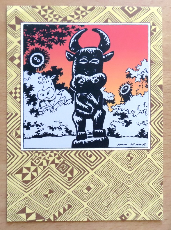
De Moor Johan:
Ex-libris.
Ex-libris au format 15 x 21.
书商的参考编号 : 23827
|
|
|
DE ROSSI Giuseppe (Roma 1560 - 1639)
(Emisfero Orientale)
Foglio contenente sei fusi del Globo Terrestre, edito da Giuseppe de Rossi a Roma nel 1615.Il foglio costituisce la metà, raffigurante l'emisfero orientale, del celebre ed importante Globo Terrestre della tipografia De Rossi, replica italiana del più famoso globo di Jodocus Hondius, stampato ad Amsterdam nel 1601. La carta si estende dalle isole dell'Atlantico alle Indie Orientali, comprendendo le isole di Giappone (parzialmente tagliato) e Corea (qui appunto rappresentata come isola).Il solo set completo di gore di globo del de Rossi è oggi conservato alla Libray of Congress di Washington (https://www.loc.gov/item/2008627640/), mentre il solo foglio che contiene le gore qui mancanti, che coprono l'emisfero occidentale, è conservato al Marietim Museum di Rotterdam (WAE840).Sono invece noti alcuni esemplari del globo montati, tra cui quello della collezione Schmidt di Vienna, e quello del Maritime Museum di Greenwich.La peculiarità assoluta del nostro esemplare sta nel fatto che riporta in calce un imprint sconosciuto alla letteratura, Dominicus de Rubeis formis Romae ad Templum S. Marie de Pace. Domenico de Rossi, figlio o nipote di Giuseppe, è attivo a Roma nella seconda metà del XVII secolo. Fiorini (1899) descrive di Domenico de Rossi la sola ristampa del globo di Mattheus Greuter (1638) datata al 1695. Il globo terrestre di Giuseppe de Rossi – uno dei primi stampati in Italia – è una replica molto accurata dell’esemplare realizzato ad Amsterdam nel 1601 da Jodocus Hondius. Giuseppe de Rossi utilizzò le mappe di Hondius, apprezzate per la loro qualità, ma il globo è interamente realizzato in Italia e dedicato a un nobiluomo romano, come possiamo vedere dal cartiglio sul globo stesso: Ill.mo viro optimarumque artium amatori et Fautori D Paulo Mellino Romano Iosephus de Rubeis Mediolanensis devoti animi monumentum dat dicatque.Il cartiglio con dedica rivela anche la firma dell’artista e chiarifica le sue origini: Giuseppe infatti era conosciuto nella Roma dell’inizio del Seicento quale membro della nota famiglia de Rossi, già famosa a Milano per le sue stampe e mappe.Il globo presenta un secondo ampio cartiglio – nell’Oceano Pacifico – con le spiegazioni di Hondius e la data in cui è stato stampato in Italia: I[odocus] Hondius Lectori S[alutem]. In locorum longitudine hactenus mirifice peccatum esse omnibus hydrographiae peritis satis superque constat [...] Longitudinem incepimus non ab insulis fortunatis, ut Ptolemeus, sed ab ijs quae Açores vocantur, quod acus nautica ibi recte in Septentrionem vergat. Vale. Anno 1615.Un terzo cartiglio a sud dello Stretto di Magellano ci fa comprendere le conoscenze geografiche degli inizi del XVII secolo: TERRA AUSTRALIS NONDUM COGNITA (terra non ancora conosciuta).Foglio di estrema rarità.Bibliografia: Fiorini, Sfere Celesti e Terrestri di Autore Italiano, Roma 1899, pp. 271-272, 293, 369; E. L. Stevenson, Terrestrial and Celestial Globes, New Haven 1921, vol II, p. 13; P. van der Krogt, Globi Neerlandici, Utrecht 1993; The World In Your Hands. An Exhibition of Globes and Planetaria, exhibition’s catalogue of Christies Great Room in London and Museum Boerhaave in Leiden, 1995, p.42, n° 4.11; Sfere del cielo sfere della terra, exhibition’s catalogue edited by M. Milansei & R. Schmidt, Correr Museum, Venice 2007, pp. 50 and 59; Dekker, E. Globes at Greenwich (Oxford, 1999), pp. 357-9 & 482-4. Engraved plate showing 6 globe gores published by Giuseppe de Rossi in 1615, covering the Eastern Hemisphere, extended from Atlantic Ocena to the Far East. Including the Japan and Korea, here depicted as an insula (Corea ins.).This is the half set of the globe gores by Giuseppe de Rossi, known complete only for the example of the Library of Congress, while the sheet with the Western Hemisphere is preserved in the Maritiem Museum of Rotterdam. (WAE840).The peculiarity of our example is the imprint Dominicus de Rubeis formis Romae ad Templum S. Marie de Pace, not know in the literature. Domenico was the son or nephew of Giuseppe, active in Rome in the second half of 17th century.Fiorini (1899) listed by Domenico de Rossi only the late issue of the globe gores by Mattheus Greuter (1638).The terrestrial globe by Giuseppe de Rossi – one of the first printed in Italy – is a very accurate replica of the one made in Amsterdam in 1601 by Jodocus Hondius, who realized just few very detailed globes. Giuseppe de Rossi uses Hondius maps, appreciated for their quality, but the globe is entirely created in Italy and dedicated to a Roman nobleman, as we can see in the cartouche on the globe itself: Ill.mo viro optimarumque / artium amatori et Fau- / tori D Paulo Mellino Roma- / no Iosephus de Rubeis Mediolanensis devoti / animi monu- / mentum dat / dicatque. The cartouche with dedication includes also the artist’s signature and explains his origin: Giuseppe was renowned in Rome in early 17th century as a member of the well-known de Rossi family, already famous in Milan for its prints and maps.The globe bears a second large cartouche – in the Pacific Ocean – with the Hondius’ explanation and the date in which it has been printed in Italy: I[odocus] Hondius Lectori S[alutem]. / In locorum longitudine hactenus mirifice peccatum esse omnibus hydrographiae peritis satis / superque constat [...] Longitudinem / incepimus non ab insulis fortunatis, ut Ptolemeus, sed ab / ijs quae Açores vocantur, quod acus nautica ibi recte in Se- / ptentrionem vergat. Vale. / Anno 1615.A third cartouche under the Strait of Magellan let us understand the geographical knowledges of the early 17th century: TERRA AUSTRALIS NONDUM COGNITA.Very similar examples are housed at Correr Museum in Venice and in the Rudolf Schmidt’s Collection.Literature Fiorini, Sfere Celesti e Terrestri di Autore Italiano, Roma 1899, pp. 271-272, 293, 369; E. L. Stevenson, Terrestrial and Celestial Globes, New Haven 1921, vol II, p. 13; P. van der Krogt, Globi Neerlandici, Utrecht 1993; The World In Your Hands. An Exhibition of Globes and Planetaria, exhibition’s catalogue of Christies Great Room in London and Museum Boerhaave in Leiden, 1995, p.42, n° 4.11; Sfere del cielo sfere della terra, exhibition’s catalogue edited by M. Milansei & R. Schmidt, Correr Museum, Venice 2007, pp. 50 and 59; Dekker, E. Globes at Greenwich (Oxford, 1999), pp. 357-9 & 482-4.

|
|
|
De Simencourt
CARTE ITINERAIRE COMPLETE DE LA FRANCE Indiquant Les Routes Royales Avec Leur Continuation Jusque Dans Les Pays Limitrophes . Relais Et Bureaux De Poste Eaux Minerales Rivieres Et Canaux Navigables.
Paris: A. Logerot 1844. A fine map hand-coloured in outline sectioned linen-backed in original slip-case with title label to the outside slip-case worn and rubbed and cracked along some joints The map measures 96 x 66cm. In very good condition with the paper bright A fine copy of this rare map. Map. Fine. A. Logerot Hardcover
书商的参考编号 : 009581

|
|
|
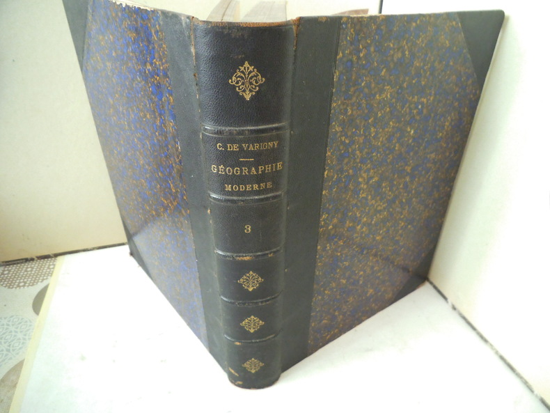
DE VARIGNY C.
ASIE
Nouvelle géographie moderne des cinq parties du monde. ASIE un volume in 4 demi-chagrin bleu à nerfs et à coins, titre, fers dorés. Faux-titre, frontispice, titre, 324 pages, tranches marbrées. Complet des 10 cartes, hors-texte, en couleurs ; Nombreuses gravures hors-texte, et en tête. Asie Mahométane (ouest) Asie Anglaise, Asie Russe, Asie bouddhiste (Est) Empire de Chine- Thibet-Mongolie-Turkestan chinois-Mongolie-Mandchourie-Corée-Empire du Japon-Indo-Chine (Annam, Tonkin, Cochinchine, Cambodge, Siam, Birmanie. Coins légèrement émoussés sinon bon exemplaire. Librairie illustrée 1890.
书商的参考编号 : 12039
|
|
|
de VAUCHELLE.
[PICARDIE] Carte de la Picardie divisée en ses différentes juridictions.
Amiens, Agnes, 1778. 525 x 665 mm.
书商的参考编号 : LBW-7185

|
|
|
de VAUCHELLES.
[ARTOIS] Carte de la province d'Artois, parties septentrionalles de la Picardie et Pays reconquis, suivant les nouvelles observations. Par M.r de Vauchelles.
Arras, En la Cité, 1778. 540 x 659 mm ; repliée sous couverture cartonnée recouverte de papier bleu de l'époque (202 x 130 mm) ; étiquette sur le premier plat portant le titre manuscrit à l'encre.
书商的参考编号 : LBW-8442

|
|
|
DE VAUGONDY Robert, Géographe Ordinaire du Roy , Corrigés par LAMARCHE Géographe successeur de Vaugondy - gravée par E. DUSSY
Carte du : LANGUEDOC, DAUPHINÉ, PROVENCE, par le Sieur DE VAUGONDY Robert, Géographe Ordinaire du Roy , Corrigés par LAMARCHE Géographe successeur de Vaugondy , 1790
Paris LAMARCHE successeur de Vaugondy 1790 carte ancienne colorée d'époque en vert , rouge et jaune, cartouche non coloré, gravée par E. DUSSY. Format total : 27 centimètres de haut par 39,8 centimètres de large, 1790 Paris : chez l'Auteur LAMARCHE successeur de Vaugondy Editeur,
书商的参考编号 : 27630
|
|
|
DE VAUGONDY Robert, Géographe Ordinaire du Roy - gravée par E. DUSSY
CARTE : LES SUISSES ET LES GRISONS AVEC LEURS ALLIÉS ET LEURS SUJETS, par Robert de Vaugondy, tiré du "Nouvel atlas portatif destiné principalement pour l'instruction de la jeunesse, et précédé d'un discours sur l'étude de la géographie", par le S. Robert de Vaugondy, 1762 Paris : chez l'Auteur ( Robert de Vaugondy) Editeur,
Paris chez l'Auteur ( Robert de Vaugondy) Editeur, 1762 carte ancienne colorée d'époque en vert , rouge et jaune, cartouche non coloré, gravée par E. DUSSY. Format total : 27 centimètres de haut par 39,8 centimètres de large, 1762 Paris : chez l'Auteur ( Robert de Vaugondy) Editeur,
书商的参考编号 : 27387
|
|
|
DE VAUGONDY Robert, Géographe Ordinaire du Roy - gravée par E. DUSSY
CARTE DE : "LANGUEDOC, DAUPHINE, PROVENCE", par Robert de Vaugondy, tiré du "Nouvel atlas portatif destiné principalement pour l'instruction de la jeunesse, et précédé d'un discours sur l'étude de la géographie", par le S. Robert de Vaugondy, 1762 Paris : chez l'Auteur ( Robert de Vaugondy) Editeur,
Paris chez l'Auteur ( Robert de Vaugondy) Editeur, 1762 carte ancienne colorée d'époque en vert , rouge et jaune, cartouche non coloré, gravée par E. DUSSY. Format total : 27 centimètres de haut par 39,8 centimètres de large, 1762 Paris : chez l'Auteur ( Robert de Vaugondy) Editeur,
书商的参考编号 : 28256
|
|
|
DE VAUGONDY Robert, Géographe Ordinaire du Roy - gravée par E. DUSSY
CARTE DE : FLANDRE FRANCOISE, PICARDIE ET ARTOIS, ISLE DE FRANCE, ORLÉANOIS, CHAMPAGNE, LORRAINE, ET ALSACE, par Robert de Vaugondy, tiré du "Nouvel atlas portatif destiné principalement pour l'instruction de la jeunesse, et précédé d'un discours sur l'étude de la géographie", par le S. Robert de Vaugondy, 1762 Paris : chez l'Auteur ( Robert de Vaugondy) Editeur,
Paris chez l'Auteur ( Robert de Vaugondy) Editeur, 1762 carte ancienne colorée d'époque en vert , rouge et jaune, cartouche non coloré, gravée par E. DUSSY. Format total : 27 centimètres de haut par 39,8 centimètres de large, 1762 Paris : chez l'Auteur ( Robert de Vaugondy) Editeur,
书商的参考编号 : 27397
|
|
|
 ?????????
 ?????PDF???
 RSS feed


