|
|
|
CRANGA
Le canton de Tramayes en 1900... à travers les cartes postales.
Editions de Saint-Seine-l'Abbaye, 1984, 105 p., broché, bon état.
Bookseller reference : 87058
|
|
|
Cranny, Michael W.; Garrod, Stan; McGuire, Margit; Birchell, Gary
Pacific Rim Discovery - Student Resource
96 pages. Gazetteer. Maps and abundant colour illustrations and photos throughout. Bit of liquid paper atop front free endpaper otherwise clean and unmarked with moderate wear. Binding tight. A quality copy. Book

|
|
|
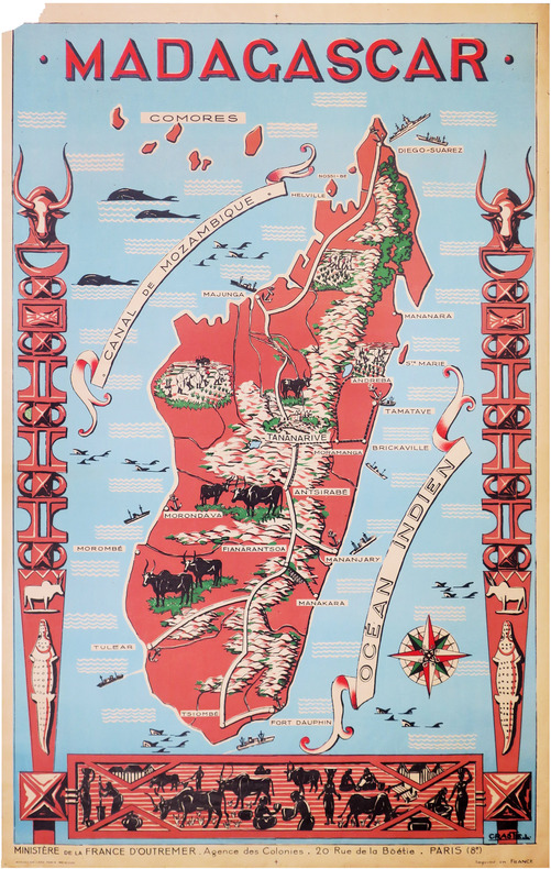
CRASTE (Léo).
[MADAGASCAR] Madagascar.
Paris, Affiches Gaillard, [vers 1950]. 1,16 x 0,74 m ; sur papier fin.
Bookseller reference : LBW-8591
|
|
|
Created by PopOut Maps
Berlin PopOut Map
Sheet map. New. Explore the vibrant city of Berlin with the help of this genuinely pocket-sized pop-up map. Small in size yet big on detail this compact dependable Berlin city map will ensure you don't miss a thing. Includes two pop-up maps covering Berlin Charlottenburg & Mitte Additional maps covering unknown
Bookseller reference : ria9781910218464_new ISBN : 1910218464 9781910218464
|
|
|
Created by PopOut Maps
Berlin PopOut Map
Sheet map. As New. Explore the vibrant city of Berlin with the help of this genuinely pocket-sized pop-up map. Small in size yet big on detail this compact dependable Berlin city map will ensure you don't miss a thing. Includes two pop-up maps covering Berlin Charlottenburg & Mitte Additional maps covering unknown
Bookseller reference : ria9781910218464_rkm ISBN : 1910218464 9781910218464
|
|
|
Created by PopOut Maps
Manchester PopOut Map
Hardback. New. Discover energetic Manchester with the help of this genuinely pocket-sized pop-up map. Small in size yet big on detail this compact dependable Manchester city map will ensure you don't miss a thing. Includes a PopOut map - a detailed street map of the city centre as well as Salford Quays and m hardcover
Bookseller reference : ria9781910218617_new ISBN : 1910218618 9781910218617
|
|
|
Created by PopOut Maps
Manchester PopOut Map
Hardback. As New. Discover energetic Manchester with the help of this genuinely pocket-sized pop-up map. Small in size yet big on detail this compact dependable Manchester city map will ensure you don't miss a thing. Includes a PopOut map - a detailed street map of the city centre as well as Salford Quays and m hardcover
Bookseller reference : ria9781910218617_rkm ISBN : 1910218618 9781910218617
|
|
|
Created by PopOut Maps
Prague PopOut Map
Paperback. New. Discover the Czech capital of Prague in all its historic beauty with the help of this genuinely pocket-sized pop-up map. Small in size yet big on detail this compact dependable Prague city map will ensure you don't miss a thing. Includes 2 PopOut maps - a detailed street map of Prague city centr paperback
Bookseller reference : ria9781910218815_new ISBN : 1910218812 9781910218815
|
|
|
Created by PopOut Maps
Prague PopOut Map
Paperback. As New. Discover the Czech capital of Prague in all its historic beauty with the help of this genuinely pocket-sized pop-up map. Small in size yet big on detail this compact dependable Prague city map will ensure you don't miss a thing. Includes 2 PopOut maps - a detailed street map of Prague city centr paperback
Bookseller reference : ria9781910218815_rkm ISBN : 1910218812 9781910218815
|
|
|
Created by International Travel Maps
South Korea / Seoul 2017
Sheet map. New. unknown
Bookseller reference : ria9781553412762_new ISBN : 1553412761 9781553412762
|
|
|
Created by International Travel Maps
South Korea / Seoul 2017
Sheet map. As New. unknown
Bookseller reference : ria9781553412762_rkm ISBN : 1553412761 9781553412762
|
|
|
Creator Compass Maps
Insideout New Orleans City Guide Insideout City Guide: New Orleans
Map Group Inc 2005-04-09. Paperback. Good. Map Group Inc paperback
Bookseller reference : SONG184587000X ISBN : 184587000X 9781845870003

|
|
|
Creator Compass Maps
Insideout Hong Kong City Guide Insideout City Guide: Hong Kong
Map Group Inc 2006-02-28. Hardcover. Good. Map Group Inc hardcover
Bookseller reference : SONG1904766722 ISBN : 1904766722 9781904766728

|
|
|
Creator Compass Maps
Insideout San Francisco City Guide San Francisco Insideout City Guide
Map Group Inc 2006-02-09. Hardcover. Good. Map Group Inc hardcover
Bookseller reference : SONG1904766641 ISBN : 1904766641 9781904766643

|
|
|
Creator Ltd. Compass Maps
Berlin Insideout City Guide Insideout City Guide: Berlin
Very Good. Used book in very good condition. Some cover wear may contain a few marks. 100% guaranteed. 060220 unknown
Bookseller reference : 1904766005[vg] ISBN : 1904766005 9781904766001

|
|
|
Creator Ltd. Compass Maps
Insideout Berlin City Guide Insideout City Guide: Berlin
Map Group Inc 2003-12. Paperback. Good. Map Group Inc paperback
Bookseller reference : SONG1904766005 ISBN : 1904766005 9781904766001
|
|
|
Creator Streetwise Maps
Streetwise Orlando
Streetwise Maps 2001-07-01. Map. Good. Streetwise Maps unknown
Bookseller reference : SONG1886705402 ISBN : 1886705402 9781886705401

|
|
|
Creator Time Traveler Maps
The Colorado Plateau: Map & Guide to Public Lands on the Colorado Plateau & its Borderlands
Time Traveler Maps 2004-06. Map. Good. Time Traveler Maps unknown
Bookseller reference : SONG1892040166 ISBN : 1892040166 9781892040169
|
|
|
Creighton, John
Cheshire: A Portrait in Words and Pictures
Neat inscription to front end paper. No other marks or inscriptions. Very minor creasing to lower corner of front cover, none to rear or to spine. A very clean very tight copy with bright unmarked boards, a trace of sunning to lower front edge and no bumping to corners. 156pp. A guide to Cheshire, its history, its places to visit and its industry and industrial heritage. Well illustrated.

|
|
|
CREPY (Etienne-Louis).
Carte nouvelle des environs de Paris contenant aussy la Brie.
Paris, Crépy, 1753. En 16 sections montées sur toile et pliées, formant une carte de 503 x 718 mm.
Bookseller reference : LBW-747
|
|
|
Crestin-Billet Frédérique
La Folie des cartes à jouer
Flammarion 2002 In-18 broché 14 cm sur 14. 377 pages. Très bon état d’occasion.
Bookseller reference : 98198
|
|
|
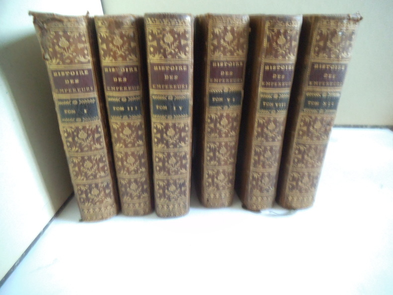
CREVIER
Histoire des empereurs romains
depuis Auguste jusqu’à Constantin.6 volumes en 6 tomes sur 12.Tomes 1,3,4,6,8,12,in 12 plein veau glacé fauve,pièce de titre chagrin rouge et pièce de tomaison chagrin vert, fars,roulette,palmette dorés.roulette dorée sur coupes. Tome :faux-titre,titre,XVIII,2 cartes dépliantes La Palestine par le Sieur d’Anville 1750.Germanie et les pays situés entre le Danube et la mer Adriatique par le sieur d’Anville 1749.529 pages,22 pages de table.Tome 3:titre, carte dépliante La Grande Bretagne par le sieur d’Anville Mars 1750 480 pages,14 pages de table.Tome 4:titre,518 pages,18 pages de table et approbation. Tome 6:titre,II,539 pages,20 pages de table et fautes à corriger. Mouillure, longitudinale en fin de volume, et en tête en début de volume. Tome VIII titre,I,494 pages,18 pages de table et fautes à corriger. Tome XII titre,600 pages pâle mouillure en tête. Desaint & Saillant 1749-1755.
Bookseller reference : 6560
|
|
|
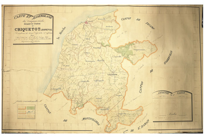
CRIQUETOT-l'ESNEVAL. MANUSCRIT.
Carte et assemblage des communes rurales formant le canton de Criquetot Lesneval, arrondissement du Havre, département de la Seine-Inférieure. Dressée sous l’administration de M. Le Bon de Vanssay, préfet, & de M. Le Cher de Merval, directeur des contributions du cadastre, par B. Girard et F. Carbonnie, géomètres en chef du cadastre.
1827. 1275 x 2000 mm.
Bookseller reference : LBW-660
|
|
|
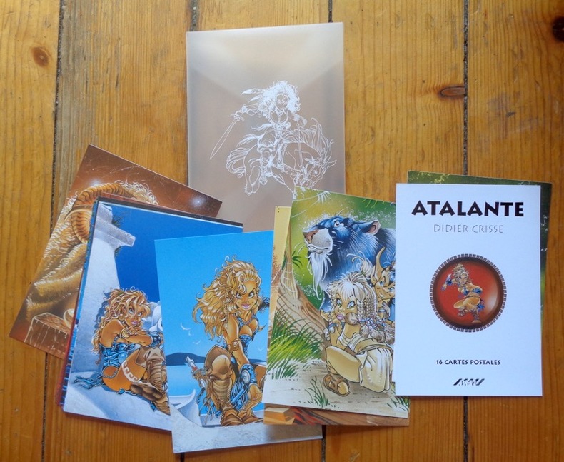
CRISSE Didier
Atalante - 16 cartes postales
16 cartes postales sous pochette translucide (Ref.: ref95693)
Bookseller reference : 9782845222488
|
|
|
Crisse Didier:
Atalante. 16 cartes postales.
PMJ éditions Port-folio translucide, bien complet des 16 cartes postales annoncées au feuillet de titre. A l'état de neuf.
Bookseller reference : 911
|
|
|
Crofton, Ian
Walking the Border : A Journey Between Scotland and England
Book and jacket appear in as new unread condition. 246pp. A complete walk along the Border from Gretna to Lamberton, just north of Berwick on Tweed, filled with information on nature, literature, history and the people who lived there.

|
|
|
Crookston, Peter (editor)
Village England
No inscriptions or marks. A lovely clean crisp very tight copy with bright unmarked boards and no bumping to corners. Dust jacket not price clipped or torn or creased. 256pp. Taken from the highly successful Observer Magazine series, Village England is a catalogue of all that is best in England. Twenty-four towns were chosen as centres to explore, and their surrounding villages are detailed with places to visit, things to do, national parks, model railways, places to eat and drink etc. With over 170 colour photographs, it is an introduction to the true England: quiet, picturesque, calm and beautiful.

|
|
|
Crosher, G.R.
Along the Chiltern Ways
Ex-library copy with usual (minimal) marks and stamps. A very clean very tight copy with bright unmarked boards, upper corner of front end paper clipped and no bumping to corners. Dust jacket not price clipped or marked or torn with minor traces of handling. 178pp. A study of the areas around the Icknield Ways, the two ancient green lanes that run from Goring on the Thames to beyond Royston at the edge of East Anglia.

|
|
|
Cross Robin/Dew Stephen maps
Fallen Eagle: The Last Days of the Third Reich
London: Caxton Editions 2000. reprint. Fine/Fine dust jacket. xii 292 p. photos maps appendices biblio index 8vo glossy illus boards; Caxton Editions hardcover
Bookseller reference : 23280 ISBN : 1840671548 9781840671544

|
|
|
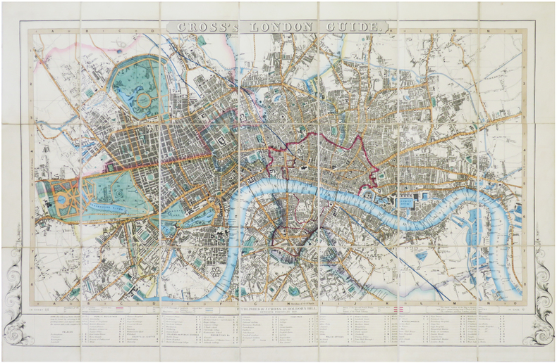
CROSS (Joseph).
[LONDRES] Cross's London guide.
London, J. Cross, [circa 1842-1843]. En 21 sections montées sur toile et pliées, formant un plan de 477 x 740 mm ; plats de papier bleu au dos, protégeant le plan une fois replié.
Bookseller reference : LBW-7239
|
|
|
CROZAL
Pour bien jouer et gagner aux cartes.
Paris, sans mention d'éditeur, sans date, 12 X 15 cm., agrafé, 45 pp. La manille, le piquet, le bésigue, l'écarté, le whist, le bridge, le poker, le rams, le trente-et-un, la banque, le nain jaune. Couverture illustrée en couleurs avec pli et déchirure, et partiellement dégrafée. Intérieur propre. Rare.
Bookseller reference : 2234

|
|
|
CROZAT. -
Abrégé de la Géographie de Crozat, par demandes et par réponses, (...); précédé d'un Traité de la Sphère. Adopté pour les Ecoles secondaires. Nouvelle édition, revue, corrigée et augmentée d'une table alphabétique des villes; avec cartes géographiques. A l'usage des jeunes gens.
Lille, Leleux, 1812, in-8°, 2 ff. + IV + 243 p., avec 2 cartes gravées dépliantespar Robert de Vaugondy (Europe et la France), papier quelque peu bruni, cartonnage en papier peint moucheté.
Bookseller reference : 29076aaf
|
|
|
CRUYL Lievin (Ghendt 1640 - 1720)
Pianta di Roma come si trova al presente colle alzate delle fabbriche piu nobili cosi antiche come moderne
La pianta del Cruyl, pubblicata per la prima volta nel 1665 dalla tipografia De Rossi, è una delle rare immagini della città che presenta contemporaneamente sia un impianto iconografico che prospettico.Le vedute presenti in questa pianta sono le stesse che furono poi oggetto di specifiche vedute intagliate dall’artista fiammingo, quasi come una sorta di catalogo personale.L’esemplare in questione è edito da Giovanni Battista De Rossi nel 1665. Sono note una ristampa con l'aggiunta di alcune vedute dei luoghi notabili ad opera di Matteo Gregorio de Rossi (1696) e un’ulteriore tiratura a cura di Carlo Losi, datata 1773.Incisa da Giulio Testone, su due matrici di rame, tracce di pieghe di carta, alcune abrasioni, nel complesso in ottimo stato di conservazione.In alto al centro il titolo: PIANTA DI ROMA COME SI TROVA AL PRESENTE COLLE ALZATE DELLE FABRICHE PIU NOBILI COSI ANTICHE COME MODERNE. Nel bordo superiore del riquadro: a sinistra L. Cruyl delin., al centro Superiorum licen. a destra Giulio Testone Romano Sculp.Opera molto rara e ricercata. Magnifico esemplare della tiratura di Carlo Losi, in perfetto stato di conservazione.BibliografiaArrigoni-Bertarelli (1939): n. 142; Christie’s (1998): p. 50, n. 1043; Ehrle (1908): p. 23; Frutaz (1962): pp. 216-217, n. CLIV, Tav. 343; Hülsen (1915): XXIV, pp. 87-89, nn. 110-111; Jatta (1992): p. 166, n. 31s; Jatta (2012); Marigliani (2007): pp. 216-217, n. 124 e p. 249, n. 155; Roma Veduta (2000): p. 175, n. 31; Scaccia Scarafoni (1939): pp. 125-126, n. 241. Etching with engraving, 1665. A fine impression, with plate tone, of the third state of three, printed on 2 sheets of contemporary laid paper, full margins, very good condition.This map was published for the first time in 1665 by De Rossi; it is one of the rare images of the city depicting, at the same time, an iconographic and perspective system. The views are the same that the Flemish artist engraved afterwards as a sort of personal catalogue. The first state has been printed by Giovanni Battista De Rossi in 1665. The plate was then published by Matteo Gregorio de Rossi in 1696 and finally reissued by Carlo Losi, in 1773. It has been engraved by Giulio Testone on two copper plates.A very rare and important map of Rome. A great example. Literature Arrigoni-Bertarelli (1939): n. 142; Christie’s (1998): p. 50, n. 1043; Ehrle (1908): p. 23; Frutaz (1962): pp. 216-217, n. CLIV, Tav. 343; Hülsen (1915): XXIV, pp. 87-89, nn. 110-111; Jatta (1992): p. 166, n. 31s; Jatta (2012); Marigliani (2007): pp. 216-217, n. 124 e p. 249, n. 155; Roma Veduta (2000): p. 175, n. 31; Scaccia Scarafoni (1939): pp. 125-126, n. 241.

|
|
|
CRÈVECŒUR (Hector Saint-John de)
Voyage dans la Haute Pensylvanie et dans l'État de New York, par un membre adoptif de la Nation Onéida.
Paris, Maradan, 1801. 3 volumes in-8, demi-basane brune, dos lisse orné, tranches jonquille (Reliure de l'époque). Édition originale, illustrée de 3 portraits, de 4 (sur 6) planches gravées dépliantes, de 2 grandes cartes dépliantes des États-Unis et de 4 tableaux, timbres, déchirures sans manque aux cartes, petites rousseurs
Bookseller reference : PHO-1645

|
|
|
Crécy de:
Le magicien.
P.M.J éditions. Carte postale, à l'état de neuf.
Bookseller reference : 970
|
|
|
Crépon Sophie Lescaille Nathalie Vidard Estelle Collectif Lemoult Sandrine
Il était une fois... Les Baux-de-Provence
PETITE BOITE 2010 14 4x0 4x20 2cm. 2010. Broché.
Bookseller reference : 500175514

|
|
|
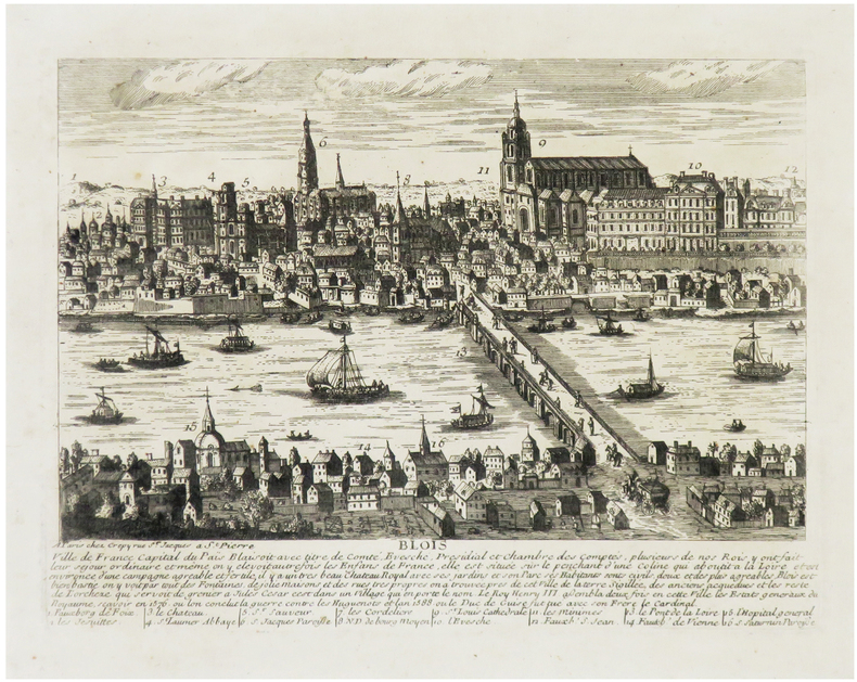
CRÉPY (Louis) & AVELINE (Pierre).
[BLOIS] Blois, ville de France, capital du Païs Blaisoit.
Paris, Crépy, [circa 1720]. 175 x 236 mm.
Bookseller reference : LBW-6819
|
|
|
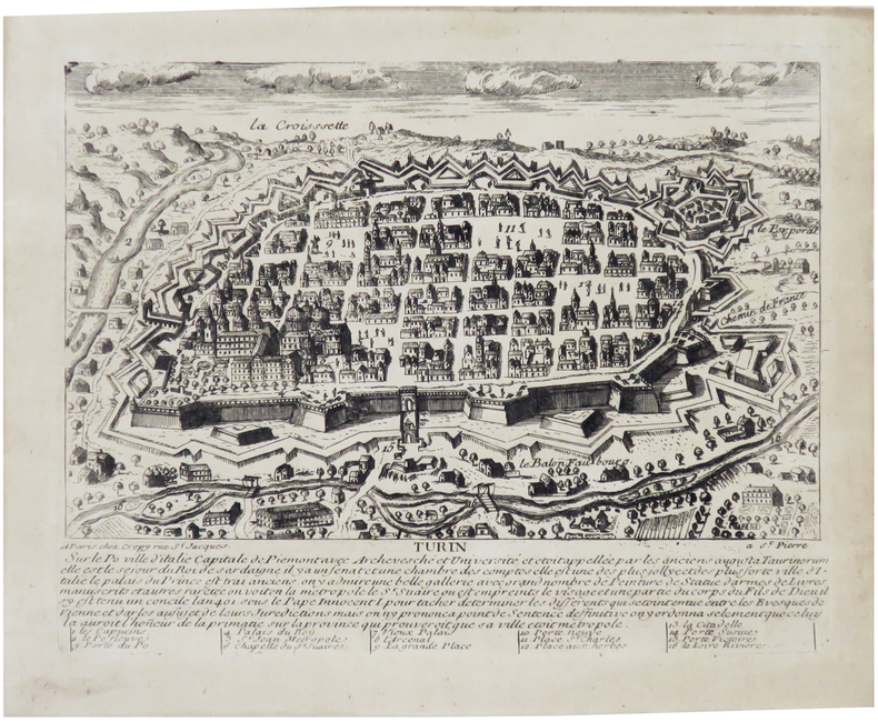
CRÉPY (Louis) & AVELINE (Pierre).
[TURIN] Turin, sur le Po, ville d'Italie, capitale de Piémont.
Paris, Crépy, [circa 1720]. 167x 213 mm.
Bookseller reference : LBW-6847
|
|
|
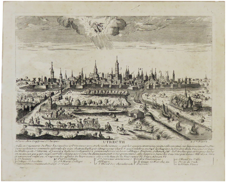
CRÉPY (Louis) & AVELINE (Pierre).
[UTRECHT] Utrecth ville et seigneurie du Pais Bas, une des 17 provinces.
Paris, Crépy, [circa 1720]. 171 x 224 mm.
Bookseller reference : LBW-6841
|
|
|
CRÉPY (Étienne-Louis).
[BERRY/BOURBONNAIS/NIVERNAIS] Les provinces de Berry, Bourbonnois et Nivernois, divisée par élections. Dressé sur les mémoires les plus nouveaux.
Paris, Crépy, 1780. 500 x 680 mm ; repliée sous couverture cartonnée recouverte de papier bleu de l'époque (195 x 127 mm) ; étiquette sur le premier plat portant le titre manuscrit à l'encre.
Bookseller reference : LBW-8430

|
|
|
CRÉPY (Étienne-Louis).
[JEU de l'OIE] Les Travaux de Mars, ou Nouveau Jeu de la Guerre, dédié à la jeune noblesse de France.
Paris, Crépy, 1767. 428 x 541 mm.
Bookseller reference : LBW-8536

|
|
|
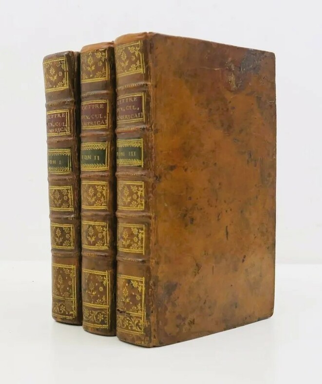
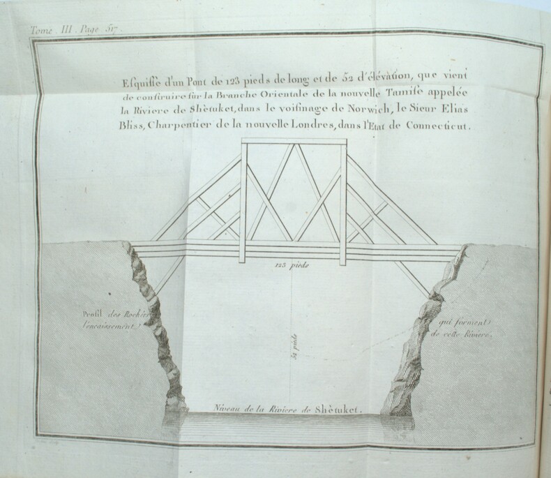
CRÉVECOEUR, (Michel Guillaume St. Jean de )
Lettres d’un cultivateur américain adressées à Wm. S on Esqr. depuis l’année 1770 jusqu’en 1786. Traduites de l’Anglois.
Paris, Cuchet, 1787. 3 vol. in-8 veau marbré, dos à nerfs ornés, p. de titre et de tomaison en mar. rouge et vert, tr. rouges (reliure de l'époque). 4ff.-xxxii-478pp-3ff., 3ff.-438pp.-5ff., 2ff.-592pp-2ff., illustrée de 3 vignettes de titre, 4 planches hors texte et 5 grandes cartes dépliantes. Qqs lég. épidermures, qqs restaurations aux coiffes et nerfs, manque de cuir en bas du second plat du tome I. Ex-libris M. Trumet, avocat. Mouillures claires par endroits. Bel exemplaire.
Bookseller reference : PHO-1655
|
|
|
CRÉVECOEUR, (Michel Guillaume St. Jean de )
Lettres d’un cultivateur américain adressées à Wm. S on Esqr. depuis l’année 1770 jusqu’en 1786. Traduites de l’Anglois.
A Paris, chez Cuchet, 1787. 3 volumes in-8, veau teinté vert de l’époque, dos lisse orné, pièces de titre et de tomaison maroquin rouge, tranches jaspées, menus défauts d’usage, 2 planches un peu brunies et qq. rouss. au vol.2). 4ff.-xxxii-478pp-3ff., 3ff.-438pp.-5ff., 2ff.-592pp-2ff.
Bookseller reference : PHO-1961
|
|
|
CS. Hammond & Co. and color Maps C. S.
Atlas of World War II: 20th Commemorative Edition
Paperback. Very Good. Softcover unpaged 7 pages paperback
Bookseller reference : 800008407
|
|
|
Cuban Tourist Commission
Panoramic and Monumental Map of HAVANA
Overall size is about 31 1/2" X 21". Map has some creasing and the top left corner has some crinkling. Includes a full size Map of Havana A Map of Marianao Interesting Places in Marianao Map of the Gulf of Mexico City of Havana Streets. Ships First Class with Delivery Confirmation. Ucar Garcia, S. A. paperback
Bookseller reference : biblio664

|
|
|
CUCCIONI Tommaso (Roma, 1790 circa – 23 agosto 1864)
Pianta Topografica di Roma
Rara pianta a proiezione verticale, orientata con il nord in alto. Incisa da Filippo Troiani per l'editore Tommaso Cuccioni. A sinistra rubrica: Indice de' principali edifizi di Roma moderna. A destra: Indice degli avanzi de' monumenti antichi posti nelle loro Regioni. "Stampata in quattro fogli. In basso notizia che cita il nome del pontefice Gregorio XVI (1830-1846), da cui la datazione al 1840 circa. Nella sua accurata rappresentazione della città il Troiani tenne certamente a riferimento la pianta del Censo edita una decina d'anni prima ma ancora di fatto attuale. In alto a sinistra dedica ad Agostino Feoli, amministratore generale della Banca Romana" (cfr. Marigliani, 2007, pp. 346-347). Acquaforte, stampata su quattro grandi fogli, tagliati, applicati su tela coeva e più volte ripiegati ad astuccio, piccole ossidazioni, per il resto in buono stato di conservazione. Bibliografia Scaccia Scarafoni (1939): n. 289; Frutaz (1962): n. 196; Marigliani (2007): pp. 346-347, n. 279. Rare vertical projection map, oriented with north at the top. Engraved by Filippo Troiani for the publisher Tommaso Cuccioni. On the left heading: Indice de' principali edifizi di Roma moderna. On the right: Indice degli avanzi de' monumenti antichi posti nelle loro Regioni. Printed in four sheets. At the bottom news that mentions the name of Pope Gregory XVI (1830-1846), hence the dating to about 1840. In its accurate representation of the city Troiani certainly held to reference the map by Census edited a decade earlier but still current. At the top left dedication to Agostino Feoli, general administrator of the Banca Romana (see Marigliani, 2007, pp. 346-347). Etching, printed on four large sheets, cut, applied on original canvas and folded several times to a case, small oxidation, otherwise in good condition. Literature Scaccia Scarafoni (1939): n. 289; Frutaz (1962): n. 196; Marigliani (2007): pp. 346-347, n. 279.

|
|
|
CUCCIONI Tommaso (Roma, 1790 circa – 23 agosto 1864)
Veduta Generale di Roma dal Gianicolo
- TERZO STATO con l'imprint della Libreria Spithöver - Terzo stato, del celebre panorama dal Gianicolo che viene attribuito alla mano di Lugi Nisi-Cavalieri (Roma XIX sec.) e Augusto Marchetti (Forli 1813 – Roma 1871) per l'editore Tommaso Cuccioni.Scrive Barbara Jatta: "L'opera non è citata dai comuni repertori e la mancanza di iscrizioni ci induce a formulare solamente delle ipotesi attributive. È noto un esemplare della stampa (Roma, BASA) che indica come editore, e committente, Tommaso Cuccioni, attivo a via Condotti n. 18. Di lui si conosce anche un piccolo panorama della città che, perfettamente corrispondente a questo in esame, seppure di dimensioni molto ridotte, reca le indicazioni A. Marchetti inc il paesaggio L. Nisi-Cavalieri inc. il Panorama. Sembra dunque possibile, vista la corrispondenza tra i due incisori, che anche la presente sia da ricondurre ai medesimi autori. […] Il Cuccioni fu anche uno dei primi e più noti fotografi romani dell'Ottocento. […] Il panorama di Roma dal Gianicolo qui esposto ha senza dubbio una stretta relazione con gli esordi della tecnica fotografica. Eseguito ad acquaforte e bulino, esso deve la sua impostazione di base all'uso di strumenti meccanici". (cfr. Barbara Jatta in Roma Veduta, p. 230).Dunque, se l'attribuzione al Nisi-Cavalieri e al Marchetti è, sebbene plausibile, puramente congetturata, la commitenza di Tommaso Cuccioni e invece certa. Fatto che ci induce ad indicarlo, in qualità di editore, commitente e fotografo, come l'autore principale di questa veduta. Della grande vedute esiste una prova di stampa, prima di gran parte dei ritocchi a bulino, che possiamo considerare un primo stato della lastra. La stesura definitiva, con ritocco a bulino e completamento della lastra, reca l'imprint "Si trova vendibile presso l'Editore Tommaso Cuccioni, Negoziante di Stampe. Roma, Via della Croce n. 88". L'indirizzo di via della Croce 88 mette anche in dubbio la datazione assegnata da Barbara Jatta all'opera (1848 circa) che potrebbe essere quindi anche precedente. In accordo con le sue note biografiche infatti (cfr. Marina Miraglia - Dizionario Biografico degli Italiani - Volume 31, 1985) il Cuccioni viene descritto gia attivo all'indirizzo di Via Condotti 18 nel prima della morte di papa Gregorio XVI (1846). Una datazione intorno al 1840, ci sembra più compatibile con le note biografiche.La terza stesura dell'opera - che qui presentiamo - reca l'imprint della Libreria Spithöver ed è probabilmente databile a dopo il 1864, anno della scomparsa di Cuccioni.Josef Spithöver (Sendenhorst, 11 oct. 1813 - Roma, 12 genn. 1892), nato in Germania, è stato un animatore della cultura romana di metà ottocento, gestendo una libreria-casa editrice. Fu anche un pioniere della fotografia.Acquaforte e bulino, stampata su tre fogli di carta databile alla seconda metà del'800, brunitura diffusa, macchie e ossidazioni sparse, strappi nel margine bianco, per il resto in buono stato di conservazione. - THIRD STATE with the imprint of the Spithöver Bookshop - Third state, of the famous panorama from the Janiculum Hill that is attributed to the hand of Lugi Nisi-Cavalieri (Rome XIX sec.) and Augusto Marchetti (Forli 1813 - Rome 1871) for the publisher Tommaso Cuccioni.Barbara Jatta writes: "The work is not mentioned by the common repertories and the lack of inscriptions leads us to formulate only attributive hypotheses. It is known a copy of the work (Rome, BASA) that indicates as publisher, and client, Tommaso Cuccioni, active in Rome, via Condotti n. 18. We also know of him a small panorama of the city that, perfectly corresponding to this one, even if of very small dimensions, bears the indications "A. Marchetti inc. il paesaggio L. Nisi-Cavalieri inc. il Panorama". It seems therefore possible, considering the correspondence between the two engravers, that also the present one is to be traced back to the same authors. [...] Cuccioni was also one of the first and most famous Roman photographers of the nineteenth century. [...] The panorama of Rome from the Janiculum Hill exhibited here has without doubt a close relationship with the beginnings of photographic technique. Carried out with etching and burin, it owes its basic approach to the use of mechanical instruments". (cf. Barbara Jatta in Roma Veduta, p. 230).Therefore, if the attribution to Nisi-Cavalieri and Marchetti is, although plausible, purely conjectured, the commission of Tommaso Cuccioni is certain. A fact that leads us to indicate him, as publisher, commissioner and photographer, as the main author of this view. Of the great view there is a proof, before most of the burin retouches, which we can consider a first state of the plate. The final issue, with the engraving additions, bears the imprint ""Si trova vendibile presso l'Editore Tommaso Cuccioni, Negoziante di Stampe. Roma, Via della Croce n. 88". The address of via della Croce 88 also puts in doubt the dating assigned by Barbara Jatta to the work (about 1848) that could be therefore also previous. In accordance with her biographical notes in fact (see Marina Miraglia - Dizionario Biografico degli Italiani - Volume 31, 1985) Cuccioni is described already active at the address of Via Condotti 18 before the death of Pope Gregory XVI (1846). A dating around 1840, seems to us more compatible with the biographical notes.The third issue of the work - which we present here - bears the imprint of the Libreria Spithöver and can probably be dated after 1864, the year of Cuccioni's death.Josef Spithöver (Sendenhorst, 11 oct. 1813 - Rome, 12 Jan. 1892), born in Germany, was an animator of Roman culture in the mid-nineteenth century, managing a bookshop-publishing house. He was also a pioneer of photography.Etching and engraving, printed on three sheets of paper datable to the second half of the nineteenth century, widespread burnishing, scattered stains and oxidations, tears in the white margin, otherwise in good condition. Roma Veduta, p. 230, n. 72; Marigliani p. 364, n. 298.

|
|
|
CUCCIONI Tommaso (Roma, 1790 circa – 23 agosto 1864)
Veduta Generale di Roma presa dal Monte Gianicolo
RARISSIMO PRIMO STATO Primo stato, del celebre panorama dal Gianicolo che viene attribuito alla mano di Lugi Nisi-Cavalieri (Roma XIX sec.) e Augusto Marchetti (Forli 1813 – Roma 1871) per l'editore Tommaso Cuccioni.Prova avanti i ritocchi a bulino nel paesaggio e nel grande albero a sinistra; nel nostro esemplare l’uso del bulino si limita alla quinta arborea in primo piano, che inquadra la terrazza del Gianicolo, mentre la città ed il paesaggio è delineato a solo contorno.Scrive Barbara Jatta: "L'opera non è citata dai comuni repertori e la mancanza di iscrizioni ci induce a formulare solamente delle ipotesi attributive. È noto un esemplare della stampa (Roma, BASA) che indica come editore, e committente, Tommaso Cuccioni, attivo a via Condotti n. 18. Di lui si conosce anche un piccolo panorama della città che, perfettamente corrispondente a questo in esame, seppure di dimensioni molto ridotte, reca le indicazioni A. Marchetti inc il paesaggio L. Nisi-Cavalieri inc. il Panorama. Sembra dunque possibile, vista la corrispondenza tra i due incisori, che anche la presente sia da ricondurre ai medesimi autori. […] Il Cuccioni fu anche uno dei primi e più noti fotografi romani dell'Ottocento. […] Il panorama di Roma dal Gianicolo qui esposto ha senza dubbio una stretta relazione con gli esordi della tecnica fotografica. Eseguito ad acquaforte e bulino, esso deve la sua impostazione di base all'uso di strumenti meccanici". Inoltre: "Del panorama esiste anche un esemplare inciso al tratto acquafortistico, non terminato con il bulino, e avantilettera (Biblioteca Apostolica Vaticana, Stampe Ashby, Miscell. Panorami 24) che reca solamente un timbro a secco con le iniziali C. F. ad oggi non identificate" (cfr. Barbara Jatta in Roma Veduta, p. 230).Dunque, se l'attribuzione al Nisi-Cavalieri e al Marchetti è, sebbene plausibile, puramente congetturata, la commitenza di Tommaso Cuccioni e invece certa. Fatto che ci induce ad indicarlo, in qualità di editore, commitente e fotografo, come l'autore principale di questa veduta. Il timbro a secco che la Jatta identifica in "C. F." a noi appare chiaramente come un "C. T."; monogramma che identifica - fuori ogni dubbio - Tommaso Cuccioni.La stesura definitiva, con ritocco a bulino e completamento della lastra, reca l'imprint "Si trova vendibile presso l'Editore Tommaso Cuccioni, Negoziante di Stampe. Roma, Via della Croce n. 88". L'indirizzo di via della Croce 88 mette anche in dubbio la datazione assegnata da Barbara Jatta all'opera (1848 circa) che potrebbe essere quindi anche precedente. In accordo con le sue note biografiche infatti (cfr. Marina Miraglia - Dizionario Biografico degli Italiani - Volume 31, 1985) il Cuccioni viene descritto gia attivo all'indirizzo di Via Condotti 18 nel prima della morte di papa Gregorio XVI (1846). Una datazione intorno al 1840, ci sembra più compatibile con le note biografiche.Acquaforte e bulino, stampata su tre fogli di carta databile alla prima metà del'800, con margini, in eccellente stato di conservazione. Rarissimo. VERY RARE FIRST STATE First state, of the famous panorama from the Janiculum Hill that is attributed to the hand of Lugi Nisi-Cavalieri (Rome XIX sec.) and Augusto Marchetti (Forli 1813 - Rome 1871) for the publisher Tommaso Cuccioni.A proof state, before the burin retouches in the landscape and in the large tree on the left; in our exemplar the use of the burin is limited to the foreground, which frames the terrace of the Janiculum hill, while the city and the landscape is outlined with the etching only.Barbara Jatta writes: "The work is not mentioned by the common repertories and the lack of inscriptions leads us to formulate only attributive hypotheses. It is known a copy of the work (Rome, BASA) that indicates as publisher, and client, Tommaso Cuccioni, active in Rome, via Condotti n. 18. We also know of him a small panorama of the city that, perfectly corresponding to this one, even if of very small dimensions, bears the indications "A. Marchetti inc. il paesaggio L. Nisi-Cavalieri inc. il Panorama". It seems therefore possible, considering the correspondence between the two engravers, that also the present one is to be traced back to the same authors. [...] Cuccioni was also one of the first and most famous Roman photographers of the nineteenth century. [...] The panorama of Rome from the Janiculum Hill exhibited here has without doubt a close relationship with the beginnings of photographic technique. Carried out with etching and burin, it owes its basic approach to the use of mechanical instruments". In addition: "Of the panorama there is also an exemple engraved on the etching, not finished with the burin, and before the letter (Biblioteca Apostolica Vaticana, Stampe Ashby, Miscell. Panorami 24) that bears only a mark with the initials C. F. to date unidentified" (cf. Barbara Jatta in Roma Veduta, p. 230).Therefore, if the attribution to Nisi-Cavalieri and Marchetti is, although plausible, purely conjectured, the commission of Tommaso Cuccioni is certain. A fact that leads us to indicate him, as publisher, commissioner and photographer, as the main author of this view. The mark that Barbara Jatta identifies in "C. F." clearly appears to us as a "C. T."; monogram that identifies - beyond any doubt - Tommaso Cuccioni.The final issue, with burin retouching and completion of the plate, bears the imprint "Si trova vendibile presso l'Editore Tommaso Cuccioni, Negoziante di Stampe. Roma, Via della Croce n. 88". The address of via della Croce 88 also puts in doubt the dating assigned by Barbara Jatta to the work (about 1848) that could be therefore also previous. In accordance with her biographical notes in fact (see Marina Miraglia - Dizionario Biografico degli Italiani - Volume 31, 1985) Cuccioni is described already active at the address of Via Condotti 18 before the death of Pope Gregory XVI (1846). A dating around 1840, seems to us more compatible with the biographical notes.Etching and engraving, printed on three sheets of paper datable to the first half of the 19th century, with margins, in excellent condition. Very rare. Roma Veduta, p. 230, n. 72; Marigliani p. 364, n. 298.

|
|
|
Cuff Samuel H. & James McNaughton maps & Robert Bright maps
The Face of the War 1931-1942 with 73 maps
Julian Messner Inc. Good in Fair dust jacket. 1942. First Edition; First Printing. Hardcover. Book has edgewear toning to covers and pages FFEP has name inked and a bird stamp attached small faint soil spot to bottom page ends; DJ has 4 quarter-sized chips and several smaller chips small tears and tiny nicks w/creasing rubbing to edges light toning bottom corner of front flap is clipped but price remains at top; DJ in protective Brodart cover; 290 pages . Julian Messner Inc. hardcover
Bookseller reference : M2679

|
|
|
CULBERTSON Ely
"Le compte de points Culbertson au bridge; 4-3-2-1 amélioré et simplifié avec la nouvelle règle de 3 et 4."
Paris, Editions Prisma, 1954. 12 x 19, 240 pp., broché, bon état.
Bookseller reference : 35267
|
|
|
 Receive by email
 Download as PDF document
 RSS feed


