|
Cram, Geo. F.
1889 Color Map of the Eastern Half of the State of Texas
Outer dimensions: 21.75" x 14.5". Counties individually colored. Clean and unmarked with light wear. An attractive vintage copy. Bonus: includes separate extensive list of Texas counties and cities/towns, complete with their (1889) populations. Book

|
|
|
Cram, Geo. F.
1889 Color Map of the State of Alabama
Outer dimensions: 10.75" x 14.5". Counties individually colored. Clean and unmarked with light wear. An attractive vintage copy. Book

|
|
|
Cram, Geo. F.
1889 Color Map of the State of Alaska
Outer dimensions: 10.75" x 14.5". Unmarked with light wear. A quality vintage copy. Book

|
|
|
Cram, Geo. F.
1889 Color Map of the State of Arizona
Outer dimensions: 10.75" x 14.5". Counties individually colored. Clean and unmarked with light wear. An attractive vintage copy. Bonus: includes separate extensive list of Arizona counties and cities/towns, complete with their (1889) populations. Book

|
|
|
Cram, Geo. F.
1889 Color Map of the State of California
Outer dimensions: 21.75" x 14.5". Counties individually colored. Clean and unmarked with light wear. An attractive vintage copy. Bonus: includes separate extensive list of California counties and cities/towns, complete with their (1889) populations. Book

|
|
|
Cram, Geo. F.
1889 Color Map of the State of Colorado
Outer dimensions: 10.75" x 14.5". Counties individually colored. Clean and unmarked with light wear. An attractive vintage copy. Book

|
|
|
Cram, Geo. F.
1889 Color Map of the State of Florida
Outer dimensions: 10.75" x 14.5". Counties individually colored. Clean and unmarked with light wear. An attractive vintage copy. Bonus: includes separate extensive list of Florida counties and towns/cities, complete with their populations in 1889. Book

|
|
|
Cram, Geo. F.
1889 Color Map of the State of Georgia
Outer dimensions: 10.75" x 14.5". Counties individually colored. Clean and unmarked with light wear. An attractive vintage copy. Book

|
|
|
Cram, Geo. F.
1889 Color Map of the State of Kansas
Outer dimensions: 10.75" x 14.5". Counties individually colored. Clean and unmarked with light wear. A quality vintage copy. Bonus: includes separate extensive list of Kansas counties and cities/towns, complete with (1889) population of each. Book

|
|
|
Cram, Geo. F.
1889 Color Map of the State of Louisiana
Outer dimensions: 10.75" x 14.5". Counties individually colored. Clean and unmarked with light wear. An attractive vintage copy. Bonus: includes separate list of Louisiana counties and cities/towns, complete with their (1889) populations. Book

|
|
|
Cram, Geo. F.
1889 Color Map of the State of Minnesota
Outer dimensions: 10.75" x 14.5". Counties individually colored. Clean and unmarked with light wear. An attractive vintage copy. Book

|
|
|
Cram, Geo. F.
1889 Color Map of the State of Missouri
Outer dimensions: 10.75" x 14.5". Counties individually colored. Clean and unmarked with light wear. A quality vintage copy. Bonus: includes separate extensive list of Missouri counties and cities/towns, complete with (1889) population of each. Book

|
|
|
Cram, Geo. F.
1889 Color Map of the State of Montana
Outer dimensions: 21.75" x 14.5". Counties individually colored. Clean and unmarked with light wear. A handsome vintage copy. Book

|
|
|
Cram, Geo. F.
1889 Color Map of the State of New Mexico
Outer dimensions: 10.75" x 14.5". Counties individually colored. Clean and unmarked with light wear. An attractive vintage copy. Book

|
|
|
Cram, Geo. F.
1889 Color Map of the State of Pennsylvania
Vintage state map with counties individually colored. Outer dimensions: 21.75" x 14.5". Unmarked with light wear. Center fold. A quality example. Bonus: includes separate extensive list of counties and towns/cities of Pennsylvania, indicating (1889) population of each. Book

|
|
|
Cram, Geo. F.
1889 Color Map of the State of Wyoming
Outer dimensions: 10.75" x 14.5". Counties individually colored. Clean and unmarked with light wear. One-inch opening to lower left edge. An attractive vintage copy. Bonus: includes separate list of Wyoming counties and cities/towns, complete with their (1889) populations. Book

|
|
|
Cram, Geo. F.
1889 Color Map of the States of Virginia and West Virginia
Vintage state map with counties individually colored. Outer dimensions: 21.75" x 14.5". Unmarked with light wear. Center fold. A quality example. Bonus: includes separate extensive list of counties and towns/cities for each state, indicating (1889) population of each. Book

|
|
|
Cram, Geo. F.
1889 Color Map of the World
Outer dimensions: 10.75" x 14.5". Unmarked with light wear. Color corner illustrations indicate the globe's greatest mass of land, greatest mass of water, north pole regions, and south pole regions. A quality vintage copy. Book

|
|
|
Cram, Geo. F.
1889 Color Map of Wisconsin and Michigan
Vintage state map with counties individually colored. Outer dimensions: 21.75" x 14.5". Unmarked with light wear. Center fold. A quality example. Bonus: includes separate extensive list of counties and towns/cities of Michigan, indicating (1889) population of each. Book

|
|
|
Cram, Geo. F.
1889 Color Pie Charts of World Population By Country, Continent, Religion and Race
Outer dimensions: 10.75" x 14.5". A fascinating and informative presentation of the population of the world in 1889. Main pie chart breaks illustrates the world's population by country and continent. Smaller pie charts present world population by religion and race. Clean and unmarked with light wear. A quality vintage copy. Book

|
|
|
Cram, Geo. F.
1889 Colored Map of the Oklahoma Country in the Indian Territory
Outer dimensions: 10.75" x 14.5". Clean and unmarked with light wear. An attractive vintage copy. Book

|
|
|
Cram, Geo. F.
1889 Colour Map of the Dominion of Canada
Outer dimensions: 10.75" x 14.5". Unmarked with light wear. A quality vintage copy. Book

|
|
|
Cram, Geo. F.
1889 Colour Map of the Province of Ontario, Canada
Counties individually colored. Outer dimensions: 10.75" x 14.5". Unmarked with light wear. A quality vintage copy. Book

|
|
|
Cram, Geo. F.
1899 Color Map of New York State
Counties individually colored. Outer dimensions: 21.75" x 14.5". Unmarked with moderate wear. Center fold. 2" opening to bottom edge near fold mended with archival tape. A quality vintage copy. Bonus: includes separate extensive list of New York's counties and towns/cities and their (1889) populations. Book

|
|
|
Cramm, Geo. F.
1889 Color Map of Asia, Including Expanded Views of Jerusalem, Canton and Delhi
Outside dimensions 14.5" x 21.75". Unmarked with light wear and soiling. An attractive vintage copy. Book

|
|
|
Cramm, Geo. F.
1889 Color Map of Australia and Tasmania
Outside dimensions 10.75" x 14.5". Unmarked with light wear and soiling. An attractive vintage copy. Book

|
|
|
Cramm, Geo. F.
1889 Color Map of Austria
Outside dimensions 10.75" x 14.5". Unmarked with light wear and soiling. An attractive vintage copy. Book

|
|
|
Cramm, Geo. F.
1889 Color Map of Central America
Outside dimensions 10.75" x 14.5". Unmarked with light wear and soiling. An attractive vintage copy. Book

|
|
|
Cramm, Geo. F.
1889 Color Map of China, With Inset Map of Japan
Outside dimensions 10.75" x 14.5". Unmarked with light wear and soiling. An attractive vintage copy. Book

|
|
|
Cramm, Geo. F.
1889 Color Map of Egypt, Arabia, Upper Nubia and Abyssinia
Outside dimensions 14.5" x 10.75". Unmarked with light wear and soiling. An attractive vintage copy. Book

|
|
|
Cramm, Geo. F.
1889 Color Map of Europe
Outside dimensions 10.75" x 14.5". Unmarked with light wear and soiling. An attractive vintage copy. Book

|
|
|
Cramm, Geo. F.
1889 Color Map of France
Outside dimensions 10.75" x 14.5". Local districts individually colored. Unmarked with light wear and soiling. An attractive vintage copy. Book

|
|
|
Cramm, Geo. F.
1889 Color Map of India
Outside dimensions 14.5" x 10.75". Unmarked with light wear and soiling. An attractive vintage copy. Book

|
|
|
Cramm, Geo. F.
1889 Color Map of Ireland
Outside dimensions 14.5" x 10.75". Counties individually coloured. Unmarked with light wear and soiling. An attractive vintage copy. Book

|
|
|
Cramm, Geo. F.
1889 Color Map of Italy
Outside dimensions 14.5" x 10.75". Regions individually colored. Unmarked with light wear and soiling. An attractive vintage copy. Book

|
|
|
Cramm, Geo. F.
1889 Color Map of Japan (Nihon)
Outside dimensions 14.5" x 10.75". Unmarked with light wear and soiling. An attractive vintage copy. Book

|
|
|
Cramm, Geo. F.
1889 Color Map of Palestine
Outside dimensions 14.5" x 10.75". Unmarked with light wear and soiling. 4" archival tape mend to lower right corner. An attractive vintage copy. Book

|
|
|
Cramm, Geo. F.
1889 Color Map of San Francisco, California (CA)
Outside dimensions 14.5" x 10.75". Includes many street names, prominent buildings, hotels, churches, theatres, steam roads, cable and horse roads. Unmarked with light wear and soiling. An attractive vintage copy. Book

|
|
|
Cramm, Geo. F.
1889 Color Map of Sweden and Norway
Outside dimensions 14.5" x 10.75". Unmarked with light wear and soiling. An attractive vintage copy. Book

|
|
|
Cramm, Geo. F.
1889 Color Map of the City of Minneapolis, Minnesota (MN)
Outside dimensions 14.5" x 10.75". Includes many street names. Steam and horse railroads indicated. Unmarked with light wear and soiling. An attractive vintage copy. Book

|
|
|
Cramm, Geo. F.
1889 Color Map of the City of New Orleans, Louisiana (LA)
Outside dimensions 14.5" x 10.75". Steam and horse roads indicated. Includes many street names plus lists of prominent buildings and hotels. Unmarked with light wear and soiling. An attractive vintage copy. Book

|
|
|
Cramm, Geo. F.
1889 Color Map of the City of Omaha, Nebraska (NE)
Outside dimensions 14.5" x 10.75". Includes many street names. Unmarked with light wear and soiling. An attractive vintage copy. Book

|
|
|
Cramm, Geo. F.
1889 Color Map of the City of St. Louis, Missouri (MO)
Outside dimensions 14.5" x 10.75". Steam and horse roads indicated. Includes many street names plus lists of prominent buildings, hotels, depots and theatres. Unmarked with light wear and soiling. An attractive vintage copy. Book

|
|
|
Cramm, Geo. F.
1889 Color Map of the East Indies
Outside dimensions 10.75" x 14.5". Unmarked with light wear and soiling. An attractive vintage copy. Book

|
|
|
Cramm, Geo. F.
1889 Color Map of The Turkish Empire in Europe and Asia, Greece, Roumania, Etc.
Outside dimensions 10.75" x 14.5". Unmarked with light wear and soiling. An attractive vintage copy. Book

|
|
|
Cramm, Geo. F.
1889 Color Map Showing the Territorial Growth of the United States 1776-1887
Outside dimensions 10.75" x 14.5". Unmarked with light wear and soiling. An attractive vintage copy. Book

|
|
|
Crampton C. Gregory and Steven K. Madsen design by Warren Archer maps drawn by Don Bufkin
IN SEARCH OF THE SPANISH TRAIL: SANTA FE TO LOS ANGELES 1829-1848
Salt Lake City: Gibbs-Smith Publisher Peregrine Smith Book 1994. Near Fine. 1994. First Edition. Trade Paperback. 0879056142 . First edition. "The first study to locate and map the historic Spanish Trail". Oversize about 8.5" x 11" 144 pages illustrated with photographs drawings and maps bibliography map bibliography index. Near Fine copy shallow lower corner crimping to some pages. . Gibbs-Smith Publisher [Peregrine Smith Book] [1994] paperback
Bookseller reference : 66276 ISBN : 0879056142 9780879056148

|
|
|
CRANGA
Le canton de Tramayes en 1900... à travers les cartes postales.
Editions de Saint-Seine-l'Abbaye, 1984, 105 p., broché, bon état.
Bookseller reference : 87058
|
|
|
Cranny, Michael W.; Garrod, Stan; McGuire, Margit; Birchell, Gary
Pacific Rim Discovery - Student Resource
96 pages. Gazetteer. Maps and abundant colour illustrations and photos throughout. Bit of liquid paper atop front free endpaper otherwise clean and unmarked with moderate wear. Binding tight. A quality copy. Book

|
|
|
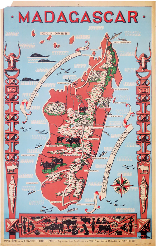
CRASTE (Léo).
[MADAGASCAR] Madagascar.
Paris, Affiches Gaillard, [vers 1950]. 1,16 x 0,74 m ; sur papier fin.
Bookseller reference : LBW-8591
|
|
 Receive by email
 Download as PDF document
 RSS feed


