|
Gecko Maps
Dharamsala McLeod Ganj Map
Gecko Maps 2009. Map. New. 2 pages. 10.00x4.30x0.30 inches. Gecko Maps unknown
Bookseller reference : __3906593371 ISBN : 3906593371 9783906593371
|
|
|
Gecko Maps
Dharamsala McLeod Ganj Tourist Map
2009-06-15. Good. Ships with Tracking Number! INTERNATIONAL WORLDWIDE Shipping available. May not contain Access Codes or Supplements. May be re-issue. May be ex-library. Shipping & Handling by region. Buy with confidence excellent customer service! unknown
Bookseller reference : 3906593371 ISBN : 3906593371 9783906593371

|
|
|
Geer Walter; Illustrated and Fold Out Maps Illustrator
Napoleon the First An Intimate Biography
Brentano's 1921-01-01. Hardcover. Acceptable. 1921. Brentanos. Hardcover. Prior owner name inside. Clean text. Tanned pages. Medium wear and scuffing. Ship same or next business day via US Mail. More Biographical books in my store. Brentano's hardcover
Bookseller reference : hcGeer
|
|
|
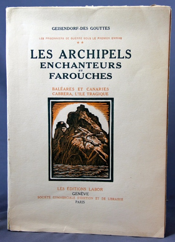
GEISENDORF-DES GOUTTES:
Les prisonniers de guerre sous le premier empire. ** Les archipels enchanteurs et farouches. Baléares et Canaries.
Genève, Ed. Labor, 1937. In-8 broché de XXXII-645 pages. Mors du 1er plat déchiré en ses extrémités.
Bookseller reference : 2238
|
|
|
Geissler, Maria.
Collection de vues des principaux palais, eglises, bâtimens publies, campagnes & jardins tant de Vienne. Ansichten Samlung der berühmtesten Palläste, Gebäude, und der schönsten Gegenden von und um Wien. Vienna, Maria Geissler, [1812].
Small oblong 8vo. Engr. t. p., 64 (instead of 100, 2 folding) plates in original watercolour. Contemp. half calf with giltstamped red label to gilt spine. Series of charming views of Vienna and its environs, including Baden, Klosterneuburg, and Bratislava, mostly engraved by Johann Jaresch. The famous streets, squares, buildings and interiors are bustling with visitors, strollers, and horse-drawn carriages. All plates are captioned in French and German, and numbered in the centre. The t. p. bears the rarely encountered publisher's address "Graben No. 1200"; individual plates are marked "Kohlmarkt No. 268". - Very attractive original colour. Wants 36 plates; 20 views are in their second state, two others in their third. The image of plate 51 has been pasted over with an alternate version. For nos. 21-24 (two doubles), Nebehay/W. also states a variant six leaves which apparently could be used to replace the panoramic views of Ebersdorf and Bratislava. - Binding slightly rubbed and bumped. Several plates trimmed closely; t. p. and a few plates show brownstaining. Contemp. ownership "L. Wagner" to pastedown. Detailed list of plates available upon request. Nebehay/Wagner 193.

|
|
|
Gelernter, Mark
A History of American Architecture: Buildings in Their Cultural and Technological Context
Book is in excellent condition. Binding is solid and square, covers have sharp corners, exterior shows no blemishes, text/interior is clean and free of marking of any kind. 346 pages with b&w illustrations on nearly every page: elevations, floorplans, b&w photos, exteriors, interiors, design drawings, landscapes, maps, facades, etc.

|
|
|
Gem Trek Maps
Banff Up-Close Map
2015-05-01. New. Ships with Tracking Number! INTERNATIONAL WORLDWIDE Shipping available. May be re-issue. Buy with confidence excellent customer service! unknown
Bookseller reference : 1895526779n ISBN : 1895526779 9781895526776

|
|
|
Gem Trek Maps
Banff Up-Close Map
2015-05-01. Good. Ships with Tracking Number! INTERNATIONAL WORLDWIDE Shipping available. May not contain Access Codes or Supplements. May be re-issue. May be ex-library. Shipping & Handling by region. Buy with confidence excellent customer service! unknown
Bookseller reference : 1895526779 ISBN : 1895526779 9781895526776

|
|
|
Gem Trek Maps
Bow Lake & Saskatchewan Crossing Map
2016-05-01. New. Ships with Tracking Number! INTERNATIONAL WORLDWIDE Shipping available. May be re-issue. Buy with confidence excellent customer service! unknown
Bookseller reference : 1895526833n ISBN : 1895526833 9781895526837

|
|
|
Gem Trek Maps
Columbia Icefield Map
2015-05-14. New. Ships with Tracking Number! INTERNATIONAL WORLDWIDE Shipping available. May be re-issue. Buy with confidence excellent customer service! unknown
Bookseller reference : 1895526787n ISBN : 1895526787 9781895526783

|
|
|
Gem Trek Maps
Lake Louise & Yoho Map
2017-05-01. New. Ships with Tracking Number! INTERNATIONAL WORLDWIDE Shipping available. May be re-issue. Buy with confidence excellent customer service! unknown
Bookseller reference : 1895526876n ISBN : 1895526876 9781895526875

|
|
|
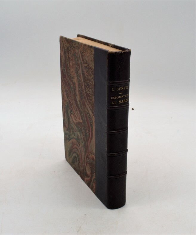
GENTIL , Louis
Dans le bled es Siba. Explorations au Maroc
Paris, Masson et Cie, 1906. in-4 (25x18) , relié demi maroquin aubergine , dos à nerfs avec auteur et titre , xv-364 , abondamment illustré
Bookseller reference : PHO-1141
|
|
|
GENEVE par Joëlle et Michel de SYON.
Genève à la Belle Epoque. La vie quotidienne en cartes postales (reproductions de cartes et de cartes postales, affiches ...)
Tribune Editions, Genève 1979. Bel exemplaire relié, reliure pleine toile, jaquette conservée, pet. In-4, 174 pages + index
Bookseller reference : AUB-8794
|
|
|
GENERALSTABEN (UDG.).
Generalstabens topographiske Kort over Danmark. (Sjælland, Møen og nogle Smaaøer i 15 kortblade). 1:80.000.
Kjøbenhavn, Generalstaben, 1847-64. Omfattende samling af kobberstukne kortblade, hvert blad måler 43x52 cm. Foldet og opbevaret i en samtidig shirtkassette. Alle blade foldet og monteret med lærred på bagsiden og opdelt i felter. Kortbladene er kobberstukket og alle illuminerede (kobberfarvetryk). I fin stand.
Bookseller reference : 53378
|
|
|
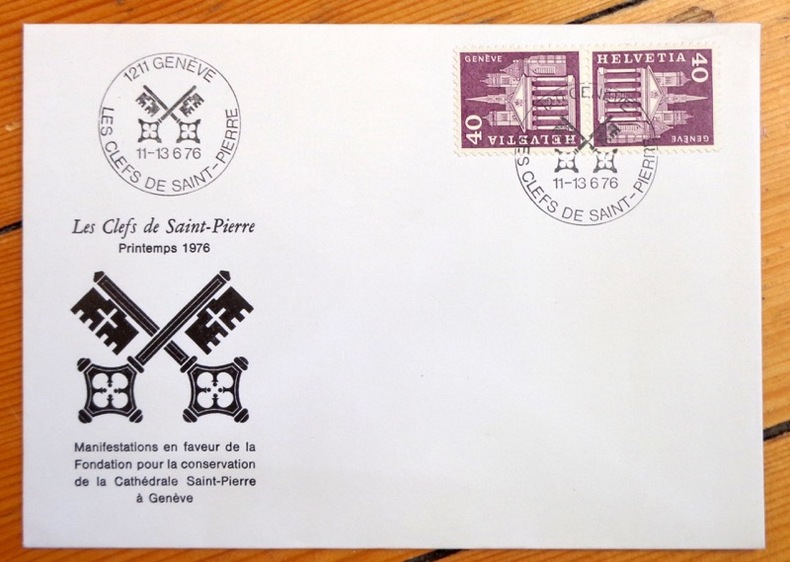
Genève:
Les Clefs de Saint-Pierre - Printemps 1976.
Les Clefs de Saint-Pierre, 1976. Enveloppe au format 16 x 11 cm., ornée d'une vignette et de 2 timbres. Affranchissement philatélique, à l'état de neuf.
Bookseller reference : 4269
|
|
|
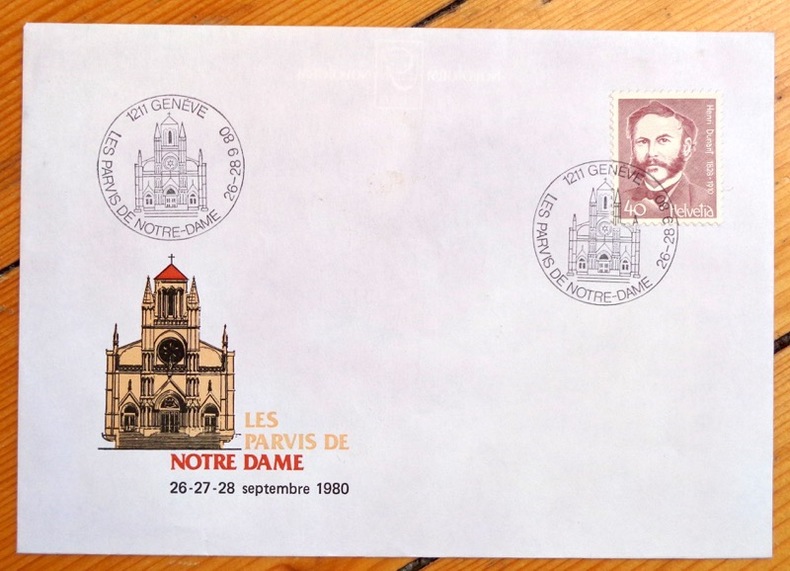
Genève:
Les parvis de Notre Dame / Henri Dunant, Genève.
1976. Enveloppe au format 16 x 11.5 cm, parue à l'occasion de la grande manifestation en faveur de la restauration de la basilique Notre Dame : Les Parvis de Notre-Dame . Timbre au portrait de Henri Dunant, vignette en coin inférieur, affranchissement philatélique de septembre 1980.
Bookseller reference : 4286
|
|
|
GENERALKONSULAT DER BUNDESREPUBLIK DEUTSCHLAND - ISTANBUL.
Das Kaiserliche Palais in Istanbul und die deutsch - türkischen Beziehungen.
As New German Paperback. Roy. 8vo. (24 x 17 cm). In German. 77, [1] p., b/w ills. Kaiserliche Palais in Istanbul und die deutsch - türkischen Beziehungen. Imperial Palace in Istanbul and the German - Turkish relations. Contents: Ekkehard Eickhoff; "Auf historischem Boden"; Klaus Nohlen; "Reprasentation und Sparsamkeit. Politische Aspekte beim Bau des Kaiserlichen Botschaftsgebaudes"; Gerhard Muller-Chorus; "A la recherche des aigles perdus": Armin Kossler; "Die Besuche Kaiser Wilhelms II in Konstantinopel (1889, 1898, 1917)"; Klaus Kreiser; "Die Anfange der deutsch-turkischen Hochschulbeziehungen"; Leyla Çambel; "Franz von Papen als Botschafter im deutschen Kaiserlichen Palais in Istanbul. Deutsch-turkische Beziehungen in den dreissinger und vierziger Jahren"; Hans Robert Romer; "Ein Ubermittlungsfehler und die Folgen. Im Gebaude des Generalkonsulats interniert".
|
|
|
GENERALSTABEN (UDG.).
Generalstabens topographiske Kort over Danmark. (Sjælland, Møen og nogle Smaaøer i 15 kortblade). 1:80.000.
Kjøbenhavn, Generalstaben, 1847-64. Omfattende samling af kobberstukne kortblade, hvert blad måler 43x52 cm. Foldet og opbevaret i en samtidig shirtkassette. Alle blade foldet og monteret med lærred på bagsiden og opdelt i felter. Kortbladene er kobberstukket og alle illuminerede (kobberfarvetryk). I fin stand.
|
|
|
GEORGES COLLEUIL
TAROT L'ENCHANTEUR Une nouvelle vision du tarot de Marseille suivi d'une méthode d'analyse de créativité et de connaissance de soi par le référentiel de Naissance
Broché - 14 x 22 - année 1999 - 219 pp - Editions Arkhana vox - illustrations
Bookseller reference : 16519
|
|
|
Geoffrey Palmer; Noel Lloyd
The Observer's Book of London
No marks or inscriptions. No creasing to covers or to spine. A very clean very tight copy with bright unmarked boards and very tiny bump to upper rear corner. 192pp. Revised edition of the standard Observer book on London.

|
|
|
Geographers' A-Z Map Company Staff
A-Z Leicester Street Atlas
96 pages, maps, index. eng
|
|
|
Geographia
Geographia Linen Backed Large Scale Plan of Nottingham
Linen backed folded Plan of Nottingham in excellent condition - not torn or marked or creased. Opens up to 29 x 39 inches. Covers slightly dusty/rubbed with creasing to oversized edges. 1pp. Coloured linen-backed plan of City of Nottingham and immediate surrounds. Undated ca 1930s.
|
|
|
Geographia
Vintage Denmark Map 1970
No marks or inscriptions to map or covers. Very minor creasing to covers. A very clean not torn map with bright unmarked boards. 1pp. Opens up to 23 x 30 inch vintage Geographia map of Denmark in 1970.
|
|
|
Geographic Maps National
National Geographic Trails Illustrated Map Mogollon Rim & Munds Mountain Wilderness Areas Apache-sitgreaves Coconino & Tonto National Forests: Arizona
National Geographic Maps 2010. Map. New. map edition. 2 pages. 0.25x9.25x4.25 inches. National Geographic Maps unknown
Bookseller reference : __1566955149 ISBN : 1566955149 9781566955140
|
|
|
Geographic Maps National
National Geographic Trails Illustrated Map Bradshaw Mountains Prescott National Forest: Arizona
National Geographic Maps 2010. Paperback. New. map edition. 2 pages. 0.25x9.25x4.25 inches. National Geographic Maps paperback
Bookseller reference : __1566955173 ISBN : 1566955173 9781566955171
|
|
|
Geographic National Maps
National Geographic Japan Map
NATIONAL GEOGRAPHIC MAPS DIVISION 2012. Sheet map. New. fol map edition. 2 pages. 9.25x4.25x0.10 inches. NATIONAL GEOGRAPHIC MAPS DIVISION unknown
Bookseller reference : __1566956161 ISBN : 1566956161 9781566956161

|
|
|
Geographical Section, General Staff No. 4042
British World War II Map of Walcheren-Amsterdam
38" wide by 25.5" high. Dated June, 1944. Moderate wear. Nice copy. Map

|
|
|
Geological Maps of Coal Fields of Japan No. 2
Geological map of the Hokusho coal field. Sheet Yamanoda.
1958. 1 fold. & col. geol. map 1:10000 very good. unknown
Bookseller reference : 50443
|
|
|
Geological Maps of Oil and Gas Fields of Japan No. 2
Geological map of Yokahama 1:15000.
1961. Geol. Surv. Japan. 1 fold. & col. geol. map 1:15000 plus 2 fold. & col. sheets with geol. sections. In orig. folder folder with repairs map and plates very good. unknown
Bookseller reference : 50440
|
|
|
Geological Maps of Coal Fields of Japan No. 2
Geological map of the Hokusho coal field. Sheet Saza.
1958. 1 fold. & col. geol. map 1:10000 very good. unknown
Bookseller reference : 50445
|
|
|
Geological Maps of Coal Fields of Japan No. 2
Geological map of the Hokusho coal field. Sheet Kusodomari.
1958. 1 fold. & col. geol. map 1:10000 very good. unknown
Bookseller reference : 50442
|
|
|
GEOLOGICAL MAPS KOREACHANG TW. ET AL. T. W.
Geological map of Korea 1:50.000 Busan-Gadeog sheet.
1983 Korea Institute of Energy and Resources Seoul. 18 pp. in Korean with English summary 7 pp. and captions 16 photoplts. 1 fold. & col. geol. map in pocket. unknown
Bookseller reference : 3063
|
|
|
Geological Maps of Coal Fields of Japan No. 2
Geological map of the Hokusho coal field. Sheet Senryu.
1958. 1 fold. & col. geol. map 1:10000 very good. unknown
Bookseller reference : 50444
|
|
|
Geological Maps of Coal Fields of Japan No. 2
Geological map of the Hokusho coal field. Sheet Utagaura.
1958. 1 fold. & col. geol. map 1:10000 very good. unknown
Bookseller reference : 50441
|
|
|
George E. McAvoy . Illustrated by Maps & Photos
And Then There Was One - Signed Hardcover First Edition. 1988
Littleton NH: Littleton the Crawford Press 1988 1988 Hard Cover. Illustrated. About Fine/AF. First. 8vo - over 7" - 9" tall. As New HC/DJ. First. Signed by Author. Flat signed on the Title page. 336 pages. Archival Wrapped DJ. Littleton, NH: Littleton, the Crawford Press, 1988 hardcover
Bookseller reference : 020822
|
|
|
George E. McAvoy . Illustrated by Maps & Photos
And Then There Was One - First Hardcover Edition 1988
Littleton NH: Littleton N.h.: the Crawford Press 1988 1988 Hard Cover. Illustrated. About Fine/AF. First. 8vo - over 7" - 9" tall. As New HC/DJ. First edition. 336 pages. Littleton, NH: Littleton, N.h.: the Crawford Press, 1988 hardcover
Bookseller reference : 019536
|
|
|
George E. McAvoy Illustrated by Maps & Photos
And Then There Was One
Littleton NH: the Crawford Press 1988 1988 4to - over 9�" - 12" tall. SCARCE: Large Trade Wraps. Illustrated. Near Fine/NA. First Edition. 336 pages. Archival Wrapped DJ. Littleton, NH: the Crawford Press, 1988 paperback
Bookseller reference : 019296
|
|
|
George E. McAvoy Illustrated by Maps & Photos
And Then There Was One - First Edition History of the Hotels of the Summit and the West Side of Mt. Washington.
Littleton NH: the Crawford Press 1988 1988 4to - over 9�" - 12" tall. SCARCE: Large Trade Wraps. Illustrated. Near Fine/NA. First Edition. 336 pages. Littleton, NH: the Crawford Press, 1988 paperback
Bookseller reference : 018263
|
|
|
George E. McAvoy Illustrated by Maps & Photos
And Then There Was One
Littleton NH: the Crawford Press 1988 1988 4to - over 9�" - 12" tall. SCARCE: Large Trade Wraps. Illustrated. Near Fine/NA. First Edition. 336 pages. Archival Wrapped DJ. Littleton, NH: the Crawford Press, 1988 paperback
Bookseller reference : 016515
|
|
|
George E. McAvoy . Illustrated by Maps & Photos
And Then There Was One
Littleton NH: Littleton N.h.: the Crawford Press 1988 1988 Hard Cover. Illustrated. About Fine/AF. First. 8vo - over 7" - 9" tall. As New HC/DJ. First. Signed by Author. Flat signed on the Title page. 336 pages. Littleton, NH: Littleton, N.h.: the Crawford Press, 1988 hardcover
Bookseller reference : 002514
|
|
|
George F. and Hugh F. Rankin Scheer; Illustrator Maps
Rebels and Redcoats
World Publishing 1957. First edition. Unknown Binding. Very Good. Nice looking book has minor edge wear. World Publishing unknown
Bookseller reference : 1009100033
|
|
|
George HT. Kimble; Illustrator photos Maps H. T.
Tropical Africa: Volume I Land and Livelihood and Volume II Society and Polity
20th Century Fund 1961. Hardcover. Good. Good 2 volume set of hardcovers. No dJ's. Pages are clean and unmarked. Covers show minor shelf wear. Bindings tight hinges strong.; 100% Satisfaction Guaranteed! Ships same or next business day! 20th Century Fund hardcover
Bookseller reference : 1206250025
|
|
|
George III British Library - Barnard, Sir Frederic Augusta
Bibliothecae Regiae Catalogus. (5 Bände). + Catalogue of Maps, Prints, Drawings, etc. forming the Geographica and Topographical Collection attached to the Library of his late Majesty King George the Third. (1 Band). Zusammen 6 Bände (= vollständig).. 5 Bände + 1 Band = 6 Bände (komplett). Erste und einzige Ausgabe.
London, The Trustees of the British Museum 1820-1829. Mit 2 Schabkunst-Porträts und 2 Holzschnitt-Vignetten. Gr.-2° (46 x 33,5 cm). Professionell restaurierte Pappbände der Zeit mit gedruckten Orig.-Papierrückenschildern.
Bookseller reference : 5146264

|
|
|
George Rogers Mansfield & Diagrams & Maps Photographs
Department of the Interior U.S. Geological Survey Bulletin 803 Geography Geology and Mineral Resources of the Portneuf Quadrangle Idaho
U. S. Government Printing Office. Very Good. 1929. Paperback. Very nice copy complete with fold out photo section and maps in pocket at rear. Back cover has some darkening from age and spot at the foredge back. Clean and unmarked. . U. S. Government Printing Office paperback
Bookseller reference : 23527
|
|
|
George S. May. Maps by Victor H. Hogg.
War 1812.
Mackinac Island State Park Commission. Very Good. Soft cover. 1st Edition. 1962. Mackinac Island State Park Commission paperback
Bookseller reference : 101770
|
|
|
George Shipway Maps Illustrator
The Paladin
Harcourt Brace & Jovanovich 1973-10-01. Hardcover. Used:Good. Harcourt, Brace & Jovanovich hardcover
Bookseller reference : DADAX0151707405 ISBN : 0151707405 9780151707409
|
|
|
GERSON (Roger).
[LUXEMBOURG] Diekirch, Grand-Duché de Luxembourg. Berceau et centre du tourisme luxembourgeois. Société Nationale des Chemins de Fer Luxembourgeois.
Diekirch, Syndicat d'Initiative, [vers 1950]. 985 x 600 mm.
Bookseller reference : LBW-8666

|
|
|
GERIN, DALMONT, SMITH et FONTAINE (Carte gravée par)
Algérie d'après les cartes de l'état-major et les documents du Ministère de la guerre.
Paris, Landriveau-Goujon, 1882. Carte en couleurs in-plano repliée, support toilé dans couverture cartonnée au lettrage doré. Echelle 1/11000000e. Carte No 21 - (Atlas usuel No 28 - Atlas universel No 41). Parfait état.Carte d'ensemble des rapports entre la France, l'Algérie, la Sénégambie et le Nord de l'Afrique.
Bookseller reference : 15175
|
|
|
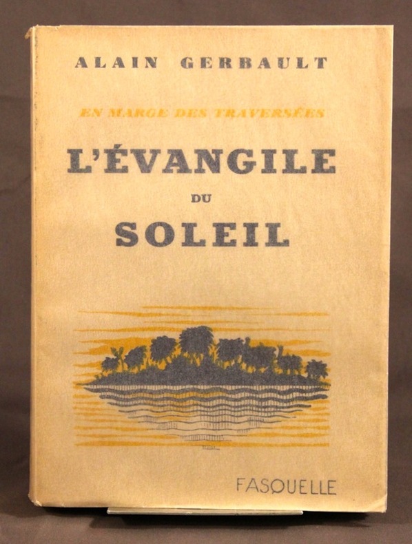
GERBAULT Alain:
L’Evangile du soleil. En marge des traversées.
Paris, Fasquelle, 1932. In-8 broché de 218-[4] pages. Bel état.
Bookseller reference : 2136
|
|
|
GERMAIN, A.:
Notions d'hydrographie expeditive à l'usage des officiers de Marine,2e edition revue par M.F.Hanusse,
Paris, Imprimerie nationale, 1904, in-4,cartonné, 119p., avec des schémas,et planches depliantes,bon etat
Bookseller reference : 10331b
|
|
 Receive by email
 Download as PDF document
 RSS feed


