|
DELAMARCHE Charles François (1740 – 1817)
Imperii Romani Tabula
Carta storico-geografica tratta dal Recueil de cartes sur la géographie ancienne et moderne, à l'usage des élèves de l'Ecole Royale Militaire de Saint-Cyr, stampatp a Parigi e pubblicato in varie edizioni tra il 1806 e il 1825. Charles François Delamarche (1740 – 1817) è stato un geografo e cartografo francese. Fu uno dei più importanti geografi e cartografi francesi della seconda metà del Settecento. Successore di Nicolas Sanson (1600-1667), Robert de Vaugondy (1686-1766) e Rigobert Bonne (1727-1794), ne ristampò gli atlanti. Si dedicò all'insegnamento della geografia. Tra le sue opere, oltre alle carte e ai globi, va ricordato un trattato sull'uso della sfera, dei globi celesti e dei terrestri (Traité de la sphère et de l'usage des globes, 1790), in cui egli illustra, oltre al sistema tolemaico, anche quello copernicano, enumerando inoltre tutte le costellazioni antiche e moderne. Suo figlio Félix ne continuò l'opera. Charles François Delamarche acquisì la collezione di Didier Robert de Vaugondy nel 1778, dopo aver collaborato con lui nell'edizione di diversi atlanti. Acquaforte, impressa su carta vergata coeva, coloritura coeva dei contorni, in ottimo stato di conservazione. Historical-geographical map taken from the Recueil de cartes sur la géographie ancienne et moderne, à l'usage des élèves de l'Ecole Royale Militaire de Saint-Cyr, printed in Paris and published in several editions between 1806 and 1825. Charles-François Delamarche (August 1740 – 31 October 1817) was a French geographer and mapmaker. One of the most important French geographers and mapmakers of the second half of the eighteenth century. Successor to Nicolas Sanson (1600 – 1667), Robert de Vaugondy (1686 – 1766), and Rigobert Bonne (1727 – 1794), whose atlases he reprinted. Also taught geography. In addition to maps and globes, his works include a treatise on the use of the sphere and celestial and terrestrial globes. In the treatise, he illustrates both the Ptolemaic and Copernican systems, as well as listing all the ancient and modern constellations. His son Félix Delamarche continued his work. Charles François Delamarche acquired Didier Robert de Vaugondy's collection in 1778, after having collaborated with him in the edition of atlases. Etching, printed on contemporary laid paper, contemporary outline coloring, in excellent condition.

|
|
|
Delaney, Frank
Betjeman Country
No marks or inscriptions. A very clean very tight copy with bright unmarked boards and no bumping to corners. Dust jacket price clipped but not marked or torn with light creasing to front. 233pp. An affectionate journey through many of the places immortalised in verse by John Betjeman. The description and history of the places is accompanied by the relevant verse.

|
|
|
Delano Alonzo edited with an introduction and notes by Irving McKee maps by Stewart Mitchell & decorations by Harry O. Diamon
Alonzo Delano's California correspondence being letters hitherto uncollected from the Ottawa Illinois Free Trader and the New Orleans True Delta 1849-1852
Sacramento: printed by the Castle Press in Pasadena CA for the Sacramento Book Collectors Club 1952. Hardcover. xxv 155p. 7.5x11 inches endpaper maps frontis introduction decorations maps very good limited edition of 310 copies bound in brick cloth boards and gilt. Journalist's letters to his newspapers AKA "Old Block printed by the Castle Press in Pasadena, CA for the Sacramento Book Collectors Club hardcover
书商的参考编号 : 212401

|
|
|
Delano Alonzo edited with an introduction and notes by Irving McKee maps by Stewart Mitchell & decorations by Harry O. Diamon
Alonzo Delano's California correspondence being letters hitherto uncollected from the Ottawa Illinois Free Trader and the New Orleans True Delta 1849-1852
Sacramento: printed by Grant Dahlstrom at the Castle Press for the Sacramento Book Collectors Club 1952. Hardcover. xxv 155p. 7.5x11 inches endpaper maps frontis introduction decorations maps very good limited edition of 310 copies bound in brick cloth boards and gilt plain tan dj. Journalist's letters to his newspapers AKA "Old Block printed by Grant Dahlstrom at the Castle Press for the Sacramento Book Collectors Club hardcover
书商的参考编号 : 212403

|
|
|
DELAROCHETTE, L. S.
Italy with the Addition of the Southern Parts of Germany as far as Pettau in Stiria ; Murlakia, Dalmatia, the adjacent countries, and all the Illyric Islands. 2d edition Jan. 1st 1802 (Map of Italy - First Part)
Carte dépliante en couleurs entoilée, au format 1120 x 635 mm, Published by Will. Faden, London, 2d edition, Jany 1st 1802 Partie nord de la carte composite en deux feuilles. Belle carte anglaise dans sa seconde édition datée d 1er janvier 1802 (la première édition datant du 12 septembre 1800). Phillips 6010, 6013, 6047 Anglais

|
|
|
Delderfield, Eric
The Observer's Book of Devon & Cornwall
No marks or inscriptions. No creasing to covers or to spine. A very clean very tight copy with unmarked lightly tanned boards, and no bumping to corners. 184pp. A guide to the two counties in England's West Country.

|
|
|
DELISLE, Guillaume ; [ De L'Isle, Guillaume ]
Carte des Pays Bas Catholiques dressée sur un grand nombre de cartes particulières faites sur les lieux où les limites sont exactement marquées, suivant les derniers Traitéz
Carte au format 66 x 48 cm, frontières rehaussée en couleur, par Guillaume De l'Isle, de l'Académie Royale des Sciences à Paris, Chez l'Auteur sur le Quai de l'Horloge, 1702 Bon état (3 très petites taches d'encre) pour cette belle carte établie et imprimée par Delisle. Français

|
|
|
DELISLE, Guillaume ; [ De L'Isle, Guillaume ]
Carte du Comté de Flandres dressée sur differens morceaux levez sur les lieux fixéz par les Observations Astronomiques.
carte au format 645 x 49 cm., frontières rehaussée en couleur, par Guillaume De l'Isle, de l'Académie Royale des Sciences à Paris, Chez l'Auteur sur le Quai de l'Horloge, 1704 Etat satisfaisant (marges rognées au maximum, petites salissures). Français

|
|
|
DELMAS YVES TEXTES ET CARTES
1945-1995 Cinquanti�me anniversaire de la lib�ration de la Poche de Royan et de Saint-Georges de Didonne. Brochure souvenir
Saint-Georges-de-Didonne 1995. 20 pp. Photographies en noir. Suppl�ment au bulletin municipal d'information de Saint Georges de Didonne n�37 . . Broch�. Bon exemplaire. A 4. Paperback
书商的参考编号 : 15370

|
|
|
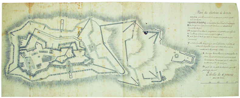
DEMONTE. MANUSCRIT.
Plan du château de Démon.
[circa 1740]. En 2 feuilles jointes de 720 x 285 mm.
书商的参考编号 : LBW-4218
|
|
|
Demeude, Hugues
Israel
Possibly unread. No marks or inscriptions. A little storage creasing to covers, none to spine. A very clean very tight copy with bright unmarked boards and no bumping to corners. 159pp. A journey to the Promised Land with its history, customs, fertile valleys, desert and holy places. Lavish photographs with captions and an associated descriptive text throughout.

|
|
|
Dempsey, Hugh A.
Glenbow, November (Nov.) - December (Dec.), 1971, Vol. 4, No. 6 - Robert Rundle Papers
8 pages. Features: Robert Rundle Papers; Rare 1841 Map of Banff Area; New Exhibition of instruments and machines which were used to titillate, entertain, and amuse; Annual Report. Black and white reproductions of archival photos. Average wear. Unmarked. A sound copy. Book

|
|
|
Dempster Thomas (Scozia, a Cliftbog, presso Aberdeen, 1579 -Bologna, 1625)
Descriptio Urbis Romae, à Romulo conditae.
Pianta di Roma antica a proiezione verticale con alzato. Tra i pochi monumenti riprodotti alcuni sono recenti, come il torrione di Niccolò V in Vaticano, la basilica di S. Paolo, la villa di Giulio III (costruita fra 1551-1553). Orientata con il Nord a sinistra.Questa pianta originariamente è inserita, ripiegata, da Bernardo Gamucci nei suoi “Libri quattro dell’antichità della città di Roma raccolte sotto brevità da diversi antichi et moderni scrittori”, prima edizione apparsa a Venezia, appresso Varisco & Compagni, nel 1565.La stessa pianta, con vari errori nei toponimi, con l’aggiunta della cornice decorativa e del testo in latino, si trova inserita anche nell’aggiornamento dell’opera di Johannes Rosinus (Johann Rossfeld) “Antiquitatum Romanorum corpus absolutissimum…” (I edizione 1585) edita da Thomas Dempster, stampata a Ginevra nel 1612 a spese di Samuel Chouët, che conobbe varie edizioni (1613, 1620, 1632, 1645, 1662, 1701, 1743). La pianta edita dal Dempster viene realizzata mediante un nuovo intaglio in legno, arricchito da una bordura ornamentale di stile nordico.Silografia, tracce delle pieghe editoriali, in ottimo stato di conservazione. Rara. Map of ancient Rome; vertical projection with elevation. Among the few monuments reproduced some are recent, such as the tower of Niccolò V in the Vatican, the basilica of S. Paolo, the villa of Giulio III (built between 1551-1553). Oriented with North to the left. This map is originally inserted, folded, by Bernardo Gamucci in his "Libri quattro dell’antichità della città di Roma raccolte sotto brevità da diversi antichi et moderni scrittori”, first edition published in Venice, Varisco & Compagni, in 1565. The same map, with various errors in the toponyms, with the addition of the decorative frame and the Latin text, is also included in the update of the work by Johannes Rosinus (Johann Rossfeld) "Antiquitatum Romanorum corpus absolutissimum ..." (1st edition 1585) published by Thomas Dempster, printed in Geneva in 1612 by Samuel Chouët, who went through various editions (1613, 1620, 1632, 1645, 1662, 1701, 1743). The map printed by Dempster is created by a new wood block, enriched by an ornamental border of Nordic style. Woodcut, traces of editorial folds, in excellent condition. Rare. cfr. Frutaz XVIII, Tav. 35; Scaccia Scarafoni, p. 26, n. 16.

|
|
|
DENIS (Louis) & PASQUIER (Jacques-Jean).
[FORÊT de FONTAINEBLEAU] Carte de la forest de Fontainebleau et de ses environs divisée en ses huit gardes.
Paris, Denis et Pasquier, 1786. En 18 sections montées sur toile et pliées, formant une carte de 540 x 685 mm.
书商的参考编号 : LBW-3219

|
|
|
DENECOURT (Claude-François).
[FORÊT de FONTAINEBLEAU] Carte topographique de la forêt & des environs de Fontainebleau.
Fontainebleau ,chez l'auteur, Paris, Andriveau-Goujon, 1844. En 18 sections montées sur toile et pliées, formant une carte de 500 x 655 mm, étiquette au dos portant le titre ; sous chemise et étui de papier marbré vert.
书商的参考编号 : LBW-6395

|
|
|
DENIS, Louis - BRUÉ, H.
Atlas topographique de l'ancienne province de Normandie et pays limitrophes, dédié en 1770 à M. Thiroux de Crosne. Revu, corrigé et augmenté en 1817, par H. Brué Géographe de S. A. R. Monsieur.
1 17 ff. de Titre (à double page) Paris, J. Goujon, 1817, in-folio de 17 feuilles, dont le Titre, montées sur onglets, reliure moderne demi-basane tabac glacée, titre or en long, gardes de papier marbré moderne, couvertures conservées, grande pièce de titre ornée contrecollée à la première de couverture ; fine restauration angulaire au titre, quelques pâles piqûres marginales à la planche 10.
书商的参考编号 : 10508
|
|
|
DENIS Fernand; FAMIN M. C:
Brésil - Colombie et Guyanes.
Paris, Firmin Didot frères, 1837. In-8 de [4]-384-[2] et 32 pages, demi-veau glacé prune, dos à nerfs orné de filets dorés, tomaison de la collection au dos.
书商的参考编号 : 15830
|
|
|
DENECOURT C.F.
CARTE TOPOGRAPHIQUE DE LA FORET ET DES ENVIRONS DE FONTAINEBLEAU
1815 carte dépliante cartonnée jaune in-douze, dos muet, manque au bas du dos sur 1 centimètre, première de couverture illustrée dans la première moitié dans un encadrement gravé en bleu titre en bleu sur fond blanc, format déplié : 55,5 centimètres de haut sur 65,5 centimètres de large, carte gravée en noir, sans date (1815) à Fontainebleau chez l'auteur et à Paris chez Andriveau-Goujon Editeurs,
书商的参考编号 : 4065
|
|
|
DENDIEVEL (Emile).
Notre Dame de Paris.
1875. 87 x 60 cm, monté sur carton et entouré d'un passe-partout sur lequel sont remontés la date, le nom de l'auteur et le titre.
书商的参考编号 : LBW-7465

|
|
|
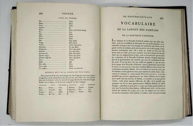
DENTRECASTEAUX (Antoine-Raymond-Joseph de Bruny) , ROSSEL (Édouard de)
Voyage de Dentrecasteaux, envoyé à la recherche de La Pérouse. Publié par ordre de sa Majesté l’Empereur et Roi, sous le ministère de S. E. le vice-amiral Decrès, comte de l’Empire. Rédigé par M. de (Édouard de) Rossel, ancien capitaine de vaisseau.
A Paris, Dépôt général des Cartes et Plans de la Marine et des Colonies, 1807 et De L’Imprimerie Impériale, 1808 RARE ENSEMBLE COMPLET en 3 volumes TEXTE ; 2 forts vol. in-4° ; (2)-LVI-704 pp.-32 pl. h.-t. repliées in-fine (I-XXXII)/(2)-VIII-692 pp.-1 pl. h.-t. Repliée sur papier bleuté , relié demi cuir , dos lisse avec titre et tomaison , tranches mouchetées , mouillure angulaire sur 7 planches, petites rousseurs sur les planches . ATLAS ; 1 volume grand in-folio (560x445) ,page de titre-1 fnch. (Table )-39 cartes et vues h.-t. , dont 29 à double page ,dressées par l'ingénieur hydrographe C. F. Beautemps Beaupré et gravées sur cuivre par E. Collin , relié demi cuir , dos lisse ,cachets répétés , petites rousseurs .
书商的参考编号 : PHO-1
|
|
|
Denison, Allen T.; Huntington, Wallace K.
Victorian Architecture of Port Townsend Washington
Book is in excellent condition. Binding is solid and square, covers have sharp corners, exterior shows no blemishes, text/interior is clean and free of marking of any kind. Dust jacket has numerous small tears at edges, now wrapped in clear protective cover. 176 pages with large b&w photos throughout, mostly exteriors, some interior, many detail shots, of commercial and public buildings, churches, residences, and misc. structures, maps, drawings; 49 individual structures featured with photos and a detailed description. Buildings include the: Fowler building, Bartlett, Waterman and katz, C.F. Clapp, Franklin House, Capt. Tibbals, Fowler-Caines, Hastings, N.D. Hill, James and Hastings, Terry, Siebenbaum, etc.
|
|
|
Denny Walter B. Bell and Colored Maps
The Career and Significance of Jesus
Hardcover. Good. Clean text.Cloth no dust jacket. hardcover
书商的参考编号 : 12576
|
|
|
Denson John editor in chief; Bacheller Martin A. editor in chief for maps
The Five Worlds of Our Lives: Ingredients and Results of War and Revolution
U.S.A. And Canada simultaneously: Newsweek Inc. and C.S. Hammond & Co. Inc. 1961 319 numbered pp; HB. Pages: clean bright tight speckled edgestain; a.e. lt tanned mildly cocked. Cover: brown padded leatherette gilt ornamentation front gilt titles spine; v lt shelfwear extrems slightly worn back b.e. bumped. An evaluation of "the deadly-sometimes hopeful-shape of things man hath wrought." Newsweek, Inc. and C.S. Hammond & Co., Inc. hardcover
书商的参考编号 : 032779
|
|
|
Denton, V.L.
The Far West Coast
297 pages including bibliography and index. "...into the heart of the vast Pacific the tale shall lead us, where men and ships are dwarfed to veriest specks which crawl laboriously a little space and then are lost to view." - from Introduction. Subjects include: the Straits of Anian; How the Russians crossed Siberia; Vitus Bering; James Cook; John Meares; George Vancouver; Quadra; and more. With 12 illustrations and 7 maps. Binding intact. Soiled but not overly so. Moderate lean to spine. Decorated biege boards. Gift greetings upon front endpaper else unmarked. Remains a decent copy. Book
|
|
|
DEPOT-GENERAL DE LA MARINE;
[BRESIL] Carte réduite des attérages du port de Maranham situés à la côte du Brésil.
Paris 1826 613 x 913 mm.
书商的参考编号 : LBW03952
|
|
|
DEPOT-GENERAL DE LA MARINE.
[GUYANE FRANCAISE] Plan de l'embouchure de la rivière de Cayenne et des mouillages extérieurs.
Paris, 1822. 578 x 888 mm.
书商的参考编号 : LBW-2413

|
|
|
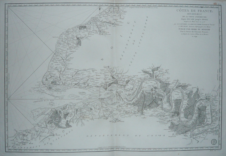
DEPOT des CARTES et PLANS de la MARINE.
[HAUTE-NORMANDIE] Côtes de France : Département de la Seine Inférieure, depuis Fécamp jusqu'à Dives.
Paris, 1792. 585 x 862 mm.
书商的参考编号 : LBW-1732
|
|
|
DEPOT des CARTES et PLANS de la MARINE.
[INDONESIE] Carte du détroit de Macassar.
Paris, 1864. 915 x 620 mm.
书商的参考编号 : LBW03578

|
|
|
DEPOT des CARTES et PLANS de la MARINE.
[PATAGONIE] Plan de la baie de l'Isthme (Isthmus Bay) (Côte occidentale de Patagonie).
Paris, 1869-1870. 641 x 468 mm.
书商的参考编号 : LBW007a9
|
|
|
DEPOT des CARTES et PLANS de la MARINE.
[PATAGONIE] Havre Grappler (Côte occidentale de Patagonie).
Paris, 1870-1880. 474 x 314 mm.
书商的参考编号 : LBW007a6

|
|
|
DEPOT des CARTES et PLANS de la MARINE.
[PATAGONIE] Plan du havre Eden (Côte occidentale de Patagonie).
Paris, 1869-1881. 640 x 470 mm.
书商的参考编号 : LBW007a7
|
|
|
DEPOT-GENERAL DE LA MARINE.
[PAYS BASQUE] Carte réduite des côtes de France, depuis le bassin d'Arcachon jusqu'à Fontarabie, et d'Espagne jusqu'au cap Machichaco.
1818. 598 x 900 mm.
书商的参考编号 : LBW03579
|
|
|
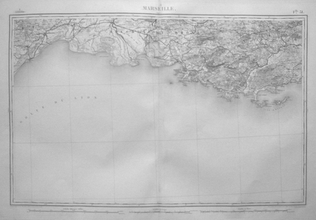
DEPOT de la GUERRE.
[PROVENCE] Marseille.
Paris, 1875. 525 x 820 mm.
书商的参考编号 : LBW0395d
|
|
|
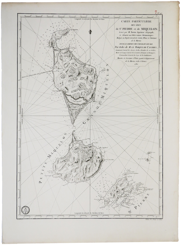
DEPOT GENERAL des CARTES PLANS et JOURNAUX de la MARINE.
[SAINT-PIERRE ET MIQUELON] Carte particulière des îles de St. Pierre et de Miquelon.
[Paris], Dépôt Général des Cartes, Plans et Journeaux de la Marine, 1782. 580 x 412 mm.
书商的参考编号 : LBW0393e
|
|
|
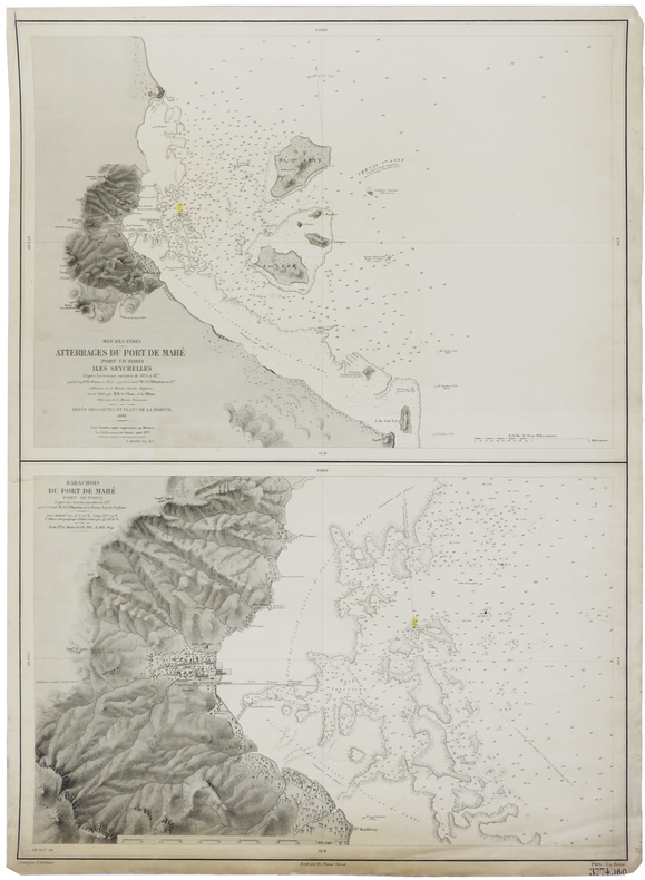
DEPOT-GENERAL DE LA MARINE.
[SEYCHELLES] Mer des Indes. Atterrages du port de Mahé, Port Victoria, Iles Seychelles. - Barachois du port de Mahé, Port Victoria.
Paris, 1880. 630 x 463 mm.
书商的参考编号 : LBW-2419
|
|
|
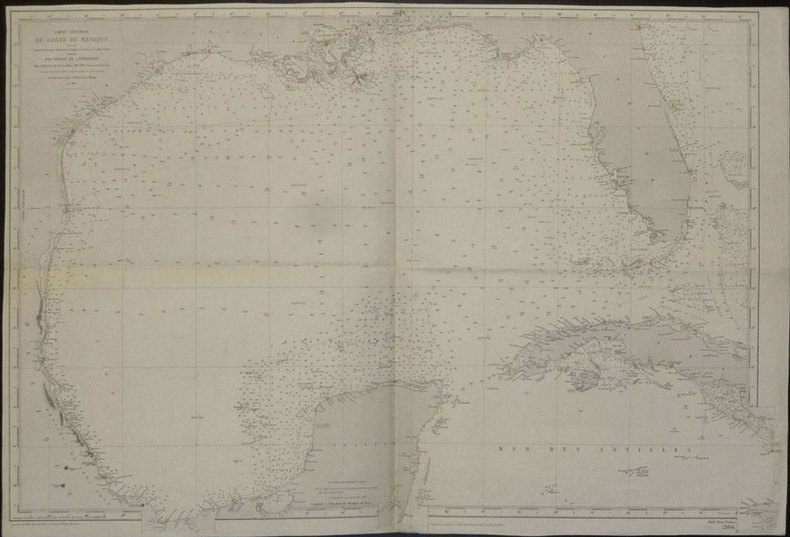
DEPOT des CARTES et PLANS de la MARINE.
[TEXAS et FLORIDE] Carte générale du golfe du Mexique dressée d'après les travaux américains, anglais et français les plus récents.
Paris, 1865-1882. 635 x 945 mm.
书商的参考编号 : LBW02e51
|
|
|
DEPOT des CARTES et PLANS de la MARINE.
[VENEZUELA et GUYANE] Amérique méridionale. Côtes du Vénézuéla et des Guyanes. Du golfe de Paria au cap d'Orange.
Paris, 1871-1881. 623 x 918 mm.
书商的参考编号 : LBW03956

|
|
|
DEPOT des CARTES et PLANS de la MARINE.
[YEMEN] Côte d'Arabie. Aden et baies adjacentes.
Paris, 1872. 611 x 892 mm.
书商的参考编号 : LBW-2421

|
|
|
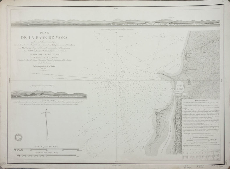
DEPOT-GENERAL DE LA MARINE.
[YEMEN] Plan de la rade de Moka.
Paris, 1843. 427 x 577 mm.
书商的参考编号 : LBW-2412
|
|
|
Depping (G.-B.)
Les jeunes voyageurs en France.
1824 Etienne Ledoux Libraire Editeur, Paris, 1824. 6 volumes in-12, reliure plein veau marbré, dos lisse orné de frises et de dentelles en queue, pièces de titre et tomaison maroquin rouge, plats ornés de filets et dentelles en encadrement, dentelles intérieures et tranches jaspées, orné de 100 cartes coloriées ou vues de ville en noir hors-texte par A.M. Perrot, gravées par Blanchard, 279, 263, 303, 241, 246 et 238 pages. Rousseurs, néanmoins bel exemplaire.
书商的参考编号 : 2750
|
|
|
Department of State; Administrative Subdivisions of Japan.
[ATLAS]. APPENDIX TO "ADMINISTRATIVE SUBDIVISIONS OF JAPAN". Department of State Publication 2749, Far Eastern Series 19.
Atlas. 47 large color folding maps. XLib. A few maps have XLib stamps in margins, otherwise maps very clean. Large folio. Spiral bound. Original stiff printed wraps, some wear. WWII 2
|
|
|
DEPOT DES CARTES ET PLANS DE LA MARINE
Analyse de la Carte Generale de l'Ocean Atlantique ou Occidental Dressee au Depot des Cartes Plans and Journaux de la Marine et Publiee par Ordre du Roi pour le service des Vaisseaux de Sa Majeste Sous le Ministere de M. le Marechal des Castries Min
Paris: de l'Imprimerie Royale 1786. 4to. 10 4/8 x 7 6/8 inches. Woodcut publisher's device on title-page and head-piece light spotting throughout. Contemporary French tree calf each cover decorated with a broad gilt border of alternating roll tools front cover detached extremities worn. First edition. Including reports by recent explorers since the publication of maps by Bellin in 1766 and de Fleurieu in 1768 - 1772 of European coastal waters and those of Africa; the Islands of the Azores the Canaries Madeira Cape Verde; America including the Gulf of St. Lawrence and Canada the Isle Royal and Arcadia the Islands of Cuba Jamaica St. Domingo Porto-Ricco the Antilles etc. Sabin 1360. Catalogued by Kate Hunter. Paris: de l'Imprimerie Royale, 1786. unknown
书商的参考编号 : 002372
|
|
|
Depot des cartes et plans de la Marine:
Antilles - Ile de Montserrat
Paris 1873. French naval chart sheet 3119 50 x33 cm black and white blank verso. Chart of the island of Montserrat in the British West Indies featuring coastal profiles dominated by the Soufri�re Hills volcano and an inset of Plymouth the former capital of the island which was destroyed in the volcanic eruptions of the mid 1990s. Map unknown
书商的参考编号 : 8667
|
|
|
Depot des cartes et plans de la Marine:
Jap�n - Cote Est de Yesso - Baie Akishi
Paris 1873. French naval chart sheet 3245 sheet size 51 x 36 cm engraved by R�gnier after a British Admiralty chart of 1871 black and white blank verso. Akkeshi Bay located in Kushiro Subprefecture on the east coast of Hokkaido the most northerly of the main islands of Japan. Map unknown
书商的参考编号 : 8669
|
|
|
Depot des cartes et plans de la Marine:
Mer M�diterran�e - Port de Smyrne
Paris 1920. French naval chart 63 x 91.5 cms black and white with beacons highlighted in yellow insets of Port d�Abri the inner harbour at modern day Izmir and two coastal profiles slightly dusty lower margin one or two closed marginal tears blank verso. Engraved in 1866 after British charts by Copeland and Spratt this example of the map was printed in September 1920 during the Greek occupation of the Zone of Smyrna part of the territory awarded to Greece at the expense of the Ottoman Empire by the Allied powers after the Great War. Smyrna became an important base for Greek forces during the resulting Greco-Turkish War of 1919-1922 and in the bloody aftermath of the Greek withdrawal half the city was razed in the Great Fire of Smyrna also known as the Smyrna Catastrophe. Map unknown
书商的参考编号 : 8575
|
|
|
Depot des cartes et plans de la Marine:
Oc�an Atlantique Nord - Iles Bermudes
Paris 1874. French naval chart sheet 3288 sheet size 67 x 99 cm engraved by Francox with tint supplied by Naudin after Er. Dumas-Vorzet black and white blank verso. The map notes that secondary corrections were made in 1874 the year of publication. This detailed chart of Bermuda was derived from British surveys of the 18th and 19th centuries. Map unknown
书商的参考编号 : 8740
|
|
|
Depot des cartes et plans de la Marine:
Oc�an Pacifique - Ile Juan Fernandez - Mouillage de San Juan Bautista
Paris 1872. French naval chart sheet 3068 sheet size 36 x 53 cm engraved by R�gnier black and white blank verso. The anchorage at San Juan Bautista located on Cumberland Bay Robinson Crusoe Island; the main settlement in the Juan Fern�ndez Islands off the coast of Chile. Map unknown
书商的参考编号 : 8668
|
|
|
DEPOT DES CARTES ET PLANS DE LA MARINE.
Route des Batiments a Vapeur dans L'Oz�an Indien. D'Aden au D�troit de la Sonde er Retour.
Paris Adolphe Lain� 1872. Folio-oblong. 325 X 52 cm. Contemp. clothbacked boards. original printed frontwrapper pasted on upper board. Stamp on title-page. 8 pp. 5 maps with colored routes. � Depot des Cartes et Plans de la Marine. No 496. hardcover
书商的参考编号 : 58001
|
|
|
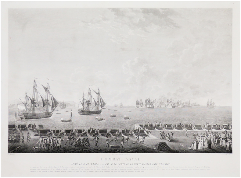
DEQUEVAUVILLER (François Jacques) & ROSSEL de CERCY (Auguste-Louis de).
Combat naval livré le 18 décembre 1779 par Mr. le Comte de La Motte Picquet chef d'escadre. Ce combat fut livré en vue du Fort Royal de la Martinique.
Paris, Bance, [circa 1810]. 530 x 725 mm.
书商的参考编号 : LBW-7244
|
|
|
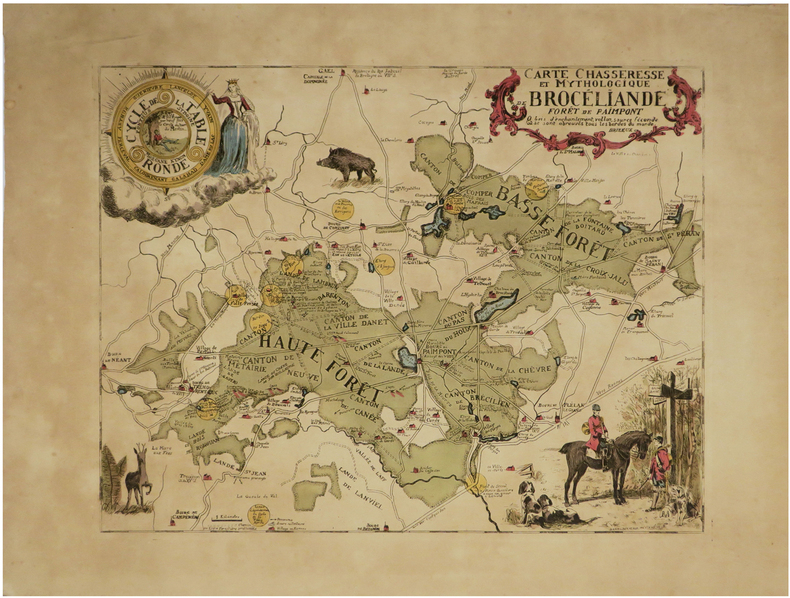
DERVEAUX (Daniel).
[FORÊT de BROCÉLIANDE] Carte chasseresse et mythologique de Brocéliande, Forêt de Paimpont.
1948. 337 x 437 mm.
书商的参考编号 : LBW-6829
|
|
 ?????????
 ?????PDF???
 RSS feed


