|
Stacey C. P.; Folding Color Maps By C. C. J. Bond
The Canadian Army 1939-1945. An Official Historical Summary
Ottawa: Miniustry Of National Defence / Edmond Cloutier 1948. 1st Edition 1st Printing. Hardcover. Very Good/Good. Illustrations From Paintings. Xvii 354 Pp. Red Cloth Gilt. Light Wear Owner's Signature Gilt Bright But Not Brilliant. Dj With Wear 2" V-Chip At Top Of Front Panel Small Losses And Tears. <br/> <br/> Miniustry Of National Defence / Edmond Cloutier hardcover
Bookseller reference : 042712
|
|
|
STACKPOLE EDWARD J. ..;..NYE WILBUR S. MAPS
SHERIDAN IN THE SHENANDOAH: JUBAL EARLY'S NEMESIS
NY: Bonanza BooksCrown. Very Good in Very Good dust jacket. 1961. Book Club Edition. HARDCOVER. 5x8". VERY GOOD CONDITION IN VERY GOOD UNCLIPTNOPR ICE DUST JACKET; BLACK SPINE TITLES ON GREY CLOTH HARD COVERS. ; Photographs maps; 413pg pages; "Lynchburg-Monocacy-Washington-Winchester Opequon-Fisher's Hill-Cedar Creek." Civil War . Bonanza Books,Crown hardcover
Bookseller reference : 120087
|
|
|
Stackpole Edward J. maps: Nye Wilbur S.
SHERIDAN IN THE SHENANDOAH Jubal Early's nemesis
New York NY: Bonanza Books. Very good condition-small wrinkle at lower edge of DJ/Dust Jacket. 1961. 8vo. 413 pp. . Bonanza Books unknown
Bookseller reference : BOOKS18888
|
|
|
Staff
Bulletin of the Pan American Union Volume 43
Vol. XLIII , July - December 1916, Nos. 274 - 279, 816 pages, with a great many b&w photos throughout. Includes trade, travel, industrial, agricultural, export, census, building data, etc. for the Latin and South American countries: Argentina, Bolivia, Brazil, Central America, Chile, Columbia, Costa Rica, Cuba, Ecuador, Dominican Republic, Guatemala Haiti, Honduras, Mexico, Nicaragua, Panama, Paraguay, etc.
|
|
|
Staff
Edwards Lithoprinted Facsimiles: Series A Document of the American Revolution Parts 1,2,3,4,5,6
Six folders each with hard plastic protective folders within, containing 5 - 20 loose leaf documents each reproducing original documents of the American revolution. Parts 1 - 6, each a separate folder, contain documents of Lexington & Concord, The tragedy of the playwright general, 20,000 pounds for West Point! the plot that failed, Amenities of Yorktown, American vs. the British, Women of the revolution. Letters, maps, edicts, etc.

|
|
|
Staff
Kelly's Post Office Directory Map of London
Red folder with some shelf wear, a few small stains, small tear at lower spine with four maps of London for the North Western Section, South Western Section, North Eastern Section and South Eastern Section. Each map is 38 x 31" (96cm X 80cm) and all are in excellent condition, showing little to no wear. Street maps are printed in half mile squares with postal districts outlined in orange. No date.

|
|
|
Staff of Heligan Gardens Ltd
The Lost Gardens of Heligan Handbook
No marks or inscriptions. Small crease to upper corner of rear cover. A very clean very tight copy with bright unmarked boards and no bumping to corners. 73pp. The essential guide to the Gardens & wider estate near St Austell in Cornwall.

|
|
|
Staff of Thomas Brothers Maps
Thomas Guide 2000 Riverside and San Diego Counties
unknown
Bookseller reference : mon0001793527 ISBN : 1581741480 9781581741483
|
|
|
Staff of Thomas Brothers Maps
Thomas Guide 2000 Riverside and San Diego Counties
Thomas Brothers Maps 1999-01-01. Paperback. Good. Thomas Brothers Maps paperback
Bookseller reference : SONG1581741480 ISBN : 1581741480 9781581741483
|
|
|
Staff; Office of Technology Assessment
Effects of Nuclear War, The
Book is in excellent condition with very bright red covers, gilt print at spine. Binding is solid and square, covers have sharp corners, exterior shows no blemishes, text/interior is clean and free of marking of any kind. Dust jacket has one 1/2" tear, a little edge wear. Previous owner's name at front endpaper. Contents include: A nuclear weapon over Detroit or Leningrad: a tutorial on the effets of nuclear weapons, Civil defense, Three attack cases, Other long-term effects, with six apendices. Lots of great graphics: maps of Detriot and Leningrad with bomb graphics over them showing PSI ratings, for instance, surface burst, air burst, casualty counts, terrorist weapon senario, radioactive graphics over Lake Erie, fireball, breakaway, shock front, Mach front, fallout, thermonuclear ground burst, lots of great stuff we can thank the Pentagon for: making us safer!

|
|
|
Stamp L. Dudley; illustrated fold out maps Illustrator
Africa a study in tropical development
John Wiley & Sons Inc 1959-01-01. Hardcover. Very Good. John Wiley & Sons, Inc hardcover
Bookseller reference : 141202208
|
|
|
Stan Jones; Illustrator maps. Illustrated by B/w illus
Washington State Fishing Guide
Stanley Jones 1984. Paperback. Good. Stanley Jones paperback
Bookseller reference : SONG093993602X ISBN : 093993602X 9780939936021
|
|
|
Stanford's Library Maps
LONDON ATLAS MAP OF CAPE OF GOOD HOPE & THE ORANGE FREE STATE
London: Edward Stanford. Hard Cover. Very Good binding. Engraved on Copper Plates in the Finest Style of the Art; "Property of M.I.D. G-2" stamped in atlas. No markings on fold-out map. Red cloth covers with beige title label. Light edgewear to head and tail of spine. Digital pictures of atlas map available upon request.; Hardcover with Fold-out Map. Very Good binding. Edward Stanford unknown
Bookseller reference : 228477

|
|
|
Stanford's Library Maps
LONDON ATLAS MAP OF CAPE OF GOOD HOPE & THE ORANGE FREE STATE
London: Edward Stanford. Hard Cover. Very Good binding. Engraved on Copper Plates in the Finest Style of the Art; "Property of M.I.D. G-2" stamped in atlas. No markings on fold-out map. Red cloth covers with beige title label. Light edgewear to head and tail of spine.Hardcover with Fold-out Map. Very Good binding. Edward Stanford unknown books
Bookseller reference : 228477
|
|
|
STANFORD'S MAP OF EAST DEVON
Stanford's Map of East Devon. [Scale One Inch to One Statute Mile.] FINE COPY AND A RARE SURVIVAL
8vo., folding coloured map on cloth measuring 28 x 34 inches (approx. 71 x 86 cms) folding in 32 panels to 7 x 4.5 inches (approx. 18 x 12 cms); strongly bound in burgundy cloth, upper board lettered in gilt, marbled endpapers, a near fine copy. VERY SCARCE IN THIS CONDITION.
|
|
|
Staniland, L. N.
THE PRINCIPLES OF LINE ILLUSTRATION. With Emphasis on the Requirements of Biological and other Scientific Workers.
pp. frontis, xii, 212. Nearly two hundred line illustrations. 8vo. Original full cloth binding. Original dust jacket. Chipped. ART 1
|
|
|
Stanley Henry and 44 Plates 5 Folding Maps
Congo & the Founding of Its Free ST Volume 2
Jan 01 1885. Hardcover. Good. 2 VOL. SET NY: Harper and Brothers 1885. Two hardcover volumes issued without dust jackets. 528pp. 483pp. woodcut illustrations 3 foldout text maps present no pocket or pocket maps at rear and no indication they ever were present although called for in the List of Illustrations thus possibly a later printing original gray-blue cloth boards with gilt lettering in overall good condition with one inner hinge starting to crack spines faded. No marks NOT EX-LIBRARY. hardcover
Bookseller reference : 10-NV4S-FLI6
|
|
|
Stanley Henry M.; Engravings Maps Etc. Illustrator
In Darkest Africa 2 Volume Set
Charles Scribner's Sons 1890-01-01. Hardcover. Good. 2 volume set. Bound in publisher's green cloth. Gilt spine. 2 maps in rear pockets. Lacking large map to Vol. I. Shelf wear. Spotting to boards of Vol. II. Inscription to Vol. I fep. Gutter crack to title page of Vol. I. Tears to maps. With one hundred and fifty woodcut illustrations. This is an oversized or heavy book that requires additional postage for international delivery outside the US. Charles Scribner's Sons hardcover
Bookseller reference : 1510260013
|
|
|
Stanley, Arthur Penrhyn.
LECTURES ON THE HISTORY OF THE JEWISH CHURCH. Part I. Abraham to Samuel. With Maps and Plans.
pp. xl, 572 + Plus two folding maps and two plans. Bookplate of Rev. L(uther) A. Gotwald, theological educator and author. Quarto. Original full cloth binding, gold lettered spine. Head of spine chipped with loss. Hardbound. First Series. JUDAICA BOX 1
|
|
|
Stanley, Arthur Penrhyn.
SINAI AND PALESTINE IN CONNECTION WITH THEIR HISTORY. Tenth Thousand. With Maps and Plans.
pp. lviii, 560, 32 [Publisher's catalogue] + Seven colored folding maps and five woodcut maps. Foxed. Offsetting from folding maps. Frontis folding map slightly torn at margin. Slight damp staining last signature. Bookplate of John D. Zimmerman. Large 8vo. 9 x 5 1/2 inches. Original full dark blue publisher's cloth binding. Gilt lettered spine. Bottom corner of front and rear boards damp stained. Hardbound. Arthur Penrhyn Stanley (1815-1881) was an English churchman, Dean of Westminster. He was a 'Broad Churchman' and was the author of various works on Church History. **PRICE JUST REDUCED! JUDAICA BOX 1
|
|
|
Stanley, Henry Morton (1841-1904).
IN DARKEST AFRICA. Or The Quest, Rescue, And Retreat Of Emin Governor Of Equatoria. With Two Steel Engravings, And One Hundred And Fifty Illustrations And Maps. In Two Volumes.
Two Volumes + Plus portrait frontis. Illustrated with steel engravings. Lacks pocket maps. Damp stained. XLib. Original marble boards repaired with black tape. Worn. AFRICA/5
|
|
|
Stannard, Dorothy (editor)
Tunisia Insight Guide
No marks or inscriptions. No creasing to covers or to spine. A very clean very tight copy with bright unmarked lightly indented boards and no bumping to corners. 344pp. With descriptions of the culture, history and tourism of the North African country this travel book takes the reader into some of its lesser known delights as well as the sand and sea tourist spots.

|
|
|
State Maps on File
State Maps on File: Midwest
New York: Facts on File Inc 1993. 300pp; maps; covers are grey with silver spine is grey with silver; pages are all clean except for felt pen on title page. Second. 3-ring Binder. Vg/No Jacket. 4to - over 9�" - 12" tall. Facts on File, Inc Hardcover
Bookseller reference : 130154 ISBN : 0816001200 9780816001200
|
|
|
State Maps on File
State Maps on File: Southwest
New York: Facts on File Inc 1984. 300pp; maps; covers are grey with silver spine is grey with silver; pages are all clean except for felt pen on title page. First. 3-ring Binder. Vg/No Jacket. 4to - over 9�" - 12" tall. Facts on File, Inc Hardcover
Bookseller reference : 130155 ISBN : 0816001227 9780816001224

|
|
|
State Maps on File
State Maps on File: Mountain & Prairie
New York: Facts on File Inc 1984. 300pp; maps; covers are grey with silver spine is grey with silver; pages are all clean except for felt pen on title page. First. 3-ring Binder. Vg/No Jacket. 4to - over 9�" - 12" tall. Facts on File, Inc Hardcover
Bookseller reference : 130156

|
|
|
State Maps on File
State Maps on File: Southeast
New York: Facts on File Inc 1994. 300pp; maps; covers are grey with silver spine is grey with silver; pages are all clean. Second. 3-ring Binder. Vg/No Jacket. 4to - over 9�" - 12" tall. Facts on File, Inc Hardcover
Bookseller reference : 130153
|
|
|
STEFAN André
Carte Postale Ancienne (CPA), portrait original en couleurs, d'une femme coiffée du Poitou.
***. Année 1940. In-12. Broché. Bon état, Couv. convenable, Dos satisfaisant, Intérieur frais. Carte postale en couleurs de 10 / 15 cm, sous verre,. . . . Classification : 240-Cartes Postales Anciennes Humoristiques
Bookseller reference : RO80078933
|
|
|
Sterne René:
Ex-libris Adler.
Le Lombard, 1995. Ex-libris couleurs, au format 20 x 26 cm. A l'état de neuf.
Bookseller reference : 8464

|
|
|
STEINMANN P / CANDIR R
HANSI A TRAVERS SES CARTES POSTALES 1895 - 1951
Ed du Rhin , 1996 , in4° cartonnage ill éditeur , 191 pp . Près de 400 reproductions !
Bookseller reference : M16027
|
|
|
Steyert (André) :
Nouvelle histoire de Lyon et des provinces de Lyonnais - Forez - Beaujolais - Franc-Lyonnais et Dombes.
Lyon, Bernoux et Cumin, 1895-1899 ; 3 tomes fort in 8, maroquin bordeaux, dos à nerfs décoré et doré du fer au lion debout, titre et tomaison dorés, encadrement d’un triple filet doré, double filet doré sur les coupes, large dentelle intérieure, tête dorée, non rogné (L. Guétant) ; 614; 668 ; 666 pp., 26 planches hors-texte, certaines sur page double, [2] pp. d’Index de ces planches ; XXIV pp. Liste des souscripteurs.
Bookseller reference : 19909

|
|
|
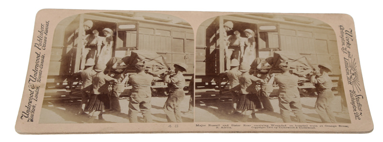
STEROSCOPE CARDS -
South African War through the Stereoscope. Vol. I-II.
Washington, Underwood & Underwood, 1900 - 1901. 72 stereoscope card (177 x 90 mm) housed in the original book-like slipcase. Slipcase with wear. Cards fine and clean.
Bookseller reference : 59848
|
|
|
STE MAURE
Carte couleurs au 1/100 000?. Feuille XIII-20.
Une feuille 57x45 cm.
|
|
|
Steele, Matthew Forney.
AMERICAN CAMPAIGN. In Two Volumes. Volume I - Text. Volume II - Maps.
Two volumes. Volume I text and Volume II maps. A few maps in Volume II torn. Both Volumes XLib. Given by the estate of William G. Price, Jr. Lieutenant General Commander of the Pennsylvania National Guard to PMC Lt. William J. Wolfgram Memorial Library. Sm. 4to. Original quarter leather over cloth covered boards. Spine on volume II very worn. Boards very fragile. Hardbound set. SHELF W21
|
|
|
Stefansson Karl; Moxham Robert M. Illustrated by Maps
Copper Bullion Claims: Rua Cove Knight Island Alaska Geological Survey Bulletin 947-E
Washington: USGPO 1946 Original Wraps. Very Good. Trade-size softcover in original printed stapled wraps. No additional printings. Pp 85 - 92; 4 maps 3 in rear pocket. Previous owner's small stamp to front cover light edgewear. VG. Quite uncommon. Ships first class. Trade Paperback. Very Good. Illus. by Maps. 8vo - over 7�" - 9�" tall. Pamphlet. USGPO paperback
Bookseller reference : 123617
|
|
|
Stefansson Vilhjalmur Olive Rathbun Wilcox editors; maps designed by Richard Edes Harrison
Great Adventures and Explorations; from the Earliest Times to the Present as told by the Explorers Themselves
New York New York: Dial Press 1952. Hardcover--cloth. Very Good/Good. Octavo 8 1/2" tall xii 788 pages red cloth. A very good clean neat hard cover with little shelf wear; hinges and binding tight paper just slightly yellowed. In a good edge worn dust jacket with chipping at the folds. Dial Press hardcover
Bookseller reference : 11489
|
|
|
Stele Franc 1886 ? Related Names: Kordija Kveder Trans; Selan Ivan Maps; Neumann Jose Ed
Slovenija: Gorenjska
Ljubljana Drzavna Zalozba Slovenije 1966 1966. First Edition. Minor annotation to the title page. Near fine copy in the original title-blocked cloth. Slightest suggestion only of dust-dulling to the spine bands and panel edges. Remains particularly well-preserved overall; tight bright clean and strong. ; 79 pages; Description: 79 1 p. Illus. part col. 27 cm. Gorenjsko Slovenia --Pictorial works. Impressively illustrated throughout. Ljubljana, Drzavna Zalozba Slovenije [1966] hardcover
Bookseller reference : 74297

|
|
|
Stembridge, Jasper H.
North America and Asia
12mo, approximately 310 pages, illustrated with many maps and plates. Former School Library copy. Edges are browned. eng
|
|
|
Stephen Polgar BScHons MSc Shane A. Thomas DipPubPol PhD MAPS
Introduction to Research in the Health Sciences
Churchill Livingstone. Paperback. GOOD. Spine creases wear to binding and pages from reading. May contain limited notes underlining or highlighting that does affect the text. Possible ex library copy will have the markings and stickers associated from the library. Accessories such as CD codes toys may not be included. Churchill Livingstone paperback
Bookseller reference : 3249833178 ISBN : 0443074291 9780443074295
|
|
|
Stephen Polgar BScHons MSc Shane A. Thomas DipPubPol PhD MAPS
Introduction to Research in Health Sciences
Churchill Livingstone. Paperback. GOOD. Spine creases wear to binding and pages from reading. May contain limited notes underlining or highlighting that does affect the text. Possible ex library copy that’ll have the markings and stickers associated from the library. Accessories such as CD codes toys may not be included. Churchill Livingstone paperback
Bookseller reference : 3191811116 ISBN : 044306265X 9780443062650

|
|
|
Stephen Polgar BScHons MSc Shane A. Thomas DipPubPol PhD MAPS
Introduction to Research in Health Sciences
Churchill Livingstone 06/15/2000. Paperback. Used; Good. WE SHIP WITHIN 24 HRS FROM LONDON UK 98% OF OUR ORDERS ARE RECEIVED WITHIN 7-10 DAYS. We believe you will be completely satisfied with our quick and reliable service. All orders are dispatched as swiftly as possible! Buy with confidence! Churchill Livingstone paperback
Bookseller reference : mon0000585686 ISBN : 044306265x 9780443062650
|
|
|
Stephen Polgar BScHons MSc; Shane A. Thomas DipPubPol PhD MAPS
Introduction to Research in the Health Sciences 5e
Churchill Livingstone 2007-11-07. Paperback. Good. Churchill Livingstone paperback
Bookseller reference : 159524 ISBN : 0443074291 9780443074295
|
|
|
Stephen Polgar BScHons MSc; Shane A. Thomas DipPubPol PhD MAPS; Stephen Polgar
Introduction to Research in the Health Sciences
Churchill Livingstone 2000-07-21. Paperback. Good. Churchill Livingstone paperback
Bookseller reference : 289950 ISBN : 044306265X 9780443062650
|
|
|
Stephen Polgar BScHons MSc Shane A. Thomas DipPubPol PhD MAPS
Introduction to Research in the Health Sciences 5e
Churchill Livingstone 2007-11-21. 5. Paperback. Used:Good. Churchill Livingstone paperback
Bookseller reference : DADAX0443074291 ISBN : 0443074291 9780443074295
|
|
|
Stephen Polgar BScHons MSc; Shane A. Thomas DipPubPol PhD MAPS
Introduction to Research in the Health Sciences
Churchill Livingstone 2007-11-07. Paperback. Good. Churchill Livingstone paperback
Bookseller reference : SONG0443074291 ISBN : 0443074291 9780443074295
|
|
|
Stereographic Maps Woodman T. I and H. Mutlow
Two engraved maps
London: Harrison & Co 1784. 1 vols. 10 x 7 3/4 inches. Extracted from a volume. Some light marginal discoloration folds else in very good condition. 1 vols. 10 x 7 3/4 inches. Maps of the Hemispheres. The first "A General Stereographic Map on the Plane of the Meridian" and the other showing a "Stereographic Projection on the Plane of the Horizon" and "Orthographic Projection on the pLane of the Meridian". <br/><br/> Harrison & Co unknown
Bookseller reference : 25892

|
|
|
STEROSCOPE CARDS -
South African War through the Stereoscope. Vol. I-II.
Washington, Underwood & Underwood, 1900 - 1901. 72 stereoscope card (177 x 90 mm) housed in the original book-like slipcase. Slipcase with wear. Cards fine and clean.
|
|
|
Steury, Donald P.; Cirillo, Roger (editor)
The Intelligence War (World War II Chronicles Series)
128 pages including index. Black and white illustrations throughout. From signals intelligence and code-cracking breakthroughs to the daring exploits of agents in the field, this work vividly chronicles the covert activities that comprised the secret war of 1939 through 1945. Written by intelligence expert Donald P. Steury, illustrated with full-color maps and period photographs, and featuring an introduction by series editor and respected WWII historian Lt. Col. Roger Cirillo, United States Army, Retired, this evocative history provides an insightful account of the significance of intelligence during World War II. Clean, bright and unmarked. Very light wear. Excellent copy. Book
|
|
|
Steve Smith
Manchester Real Ale Pub Guide
No marks or inscriptions. No creasing to covers or to spine. A very clean very tight copy with bright unmarked boards and no bumping to corners. 72pp. A real ale pub guide to supping in the city of Manchester and beyond. Very scarce.

|
|
|
Steven Cartes; Julia Sokol
Ces hommes qui ont peur d'aimer
Éditions du Club Québec Loisirs Montréal 1991. Hardcover. As New. Disclaimer:An apparently unread copy in perfect condition. Dust cover is intact; pages are clean and are not marred by notes or folds of any kind. At ThriftBooks our motto is: Read More Spend Less.Dust jacket quality is not guaranteed. Éditions du Club Québec Loisirs, Montréal hardcover
Bookseller reference : G2894300026I2N00 ISBN : 2894300026 9782894300022

|
|
|
Steven Cartes Julia Sokol
Ces hommes qui ont peur d'aimer
ditions du Club Qubec Loisirs Montral. Used - Good. Shows some signs of wear and may have some markings on the inside. ?ditions du Club Qu?bec Loisirs, Montr?al unknown
Bookseller reference : GRP76612678 ISBN : 2894300026 9782894300022
|
|
 Receive by email
 Download as PDF document
 RSS feed


