|
Directorate of Fisheries Research
Atlas of the Seas Around the British Isles
London: MINISTRy of Agriculture Fisheries and Food 1981. unpaginated colour and b/w maps Original hardback binding spiral bound fine with minimal wear. Contents clean and tight small water mark to the endpaper no inscriptions. A near fine copy. First Edition. Hard Cover. Near Fine/No dust jacket. Folio. MINISTRy of Agriculture Fisheries and Food Hardcover
书商的参考编号 : 022777 ???????? : 0907545009 9780907545002

|
|
|
Direzione Generale del Censo
Pianta Topografica di Roma pubblicata dalla Direzione Generale del Censo ed aggioranta a tutto il corrente anno MDCCCLXVI
Rara pianta della città, a proiezione verticale, orientata con il nord in alto.La pianta fu pubblicata per la prima volta nel 1829: "La pianta del Censo è senz'altro la più accurata e significativa pianta della Roma Papale nel sec. XIX. Gli edifici sono campiti a tratteggio; chiese e monumenti principali sono rappresentate con la pianta interna. L'orografia è chiaramente leggibile così come il disegno del verde. Ampia legenda sul lato sinistro ed in basso a destra elenco dei XIV rioni. È raffigurata la sola città entro il perimentro delle mura che risalta pertanto nitidamente sul fondo bianco. Il Cardinale Cesare Guerrieri, primo presidente della Congregazione dei Catasti (poi Censo) dal 1816 al 1832, fece incidere e pubblicare questa pianta, basandosi sulle mappe manoscritte del Catasto Urbano ordinate da PIO VII nel 1818 e completate nel 1822" (cfr. Marigliani p. 323). Una seconda stesura dell'opera viene alla luce nel 1854, ristampa delle lastre originali, che contiene l'indicazione del ponte di ferro costruito accanto a Ponte Rotto. La pianta fu poi definitivamente emendata nel 1866 - questa nostra edizione."E' la più accurata immagine della città subito prima che diventasse capitale. Compare il ponte di ferro a San Giovanni dei Fiorentini (1863) ed è indicata la fabbrica dei tabacchi (1863) con l'antistante Piazza Matai (1864). Ci sono le linee ferroviarie a Termini (1862) mentre manca ovviamente il fabbricato die viaggiatori (1867). È riportato infine il primo tratto di via Nazionale (fino a via Quattro Fontane), tracciata proprio nel 1866" (cfr. Marigliani p. 411).Acquaforte, stampata da 4 lastre su altrettanti fogli di carta coeva, tagliati, applicati su tela e montati ad astuccio. Tela leggermente lesionata nelle pieghe, per il resto in buono stato di conservazione.Esemplare con ex-libris della libreria di Ulderico Bossi, che aveva sede in Roma a via del Corso 401.BibliografiaA. P. Frutaz, "Le piante di Roma", n. 191; C. Marigliani, "Le Piante di Roma delle collezioni private", n. 354; Scaccia Scarafoni, "Le Piante di Roma", n. 312. Rare map of the city, with vertical projection, oriented with the north at the top.The map was published for the first time in 1829, and is undoubtedly the most accurate and significant map of Papal Rome in the nineteenth century. Wide key-legend on the left side and at the bottom right list of the XIV districts. It is represented the only city within the perimeter of the walls that stands out clearly on the white background. Cardinal Cesare Guerrieri, first president of the Congregazione dei Catasti (later Censo) from 1816 to 1832, had this map engraved and published, based on the manuscript maps of the Catasto Urban ordered by PIO VII in 1818 and completed in 1822. A second issue of the map comes to light in 1854, reprint of the original plates, which contains the indication of the iron bridge built next to Ponte Rotto. The map was then definitively amended in 1866 - our edition.It is the most accurate image of the town just before it became capital of Italy. The iron bridge appears in San Giovanni dei Fiorentini (1863) and the tobacco factory (1863) is indicated with the opposite Piazza Matai (1864). There are the railway lines at Termini (1862) while the travellers' building (1867) is obviously missing. Finally, shows the first part of Via Nazionale, traced in 1866.Etching, printed from 4 plates on 4 sheets of contemporary paper, cut, applied on canvas and mounted in a box. Canvas slightly damaged in the folds, otherwise in good condition.Exemple with ex-libris of the book seller Ulderico Bossi, which was based in Rome in via del Corso 401.BibliografiaA. P. Frutaz, "Le piante di Roma", n. 191; C. Marigliani, "Le Piante di Roma delle collezioni private", n. 354; Scaccia Scarafoni, "Le Piante di Roma", n. 312. A. P. Frutaz, "Le piante di Roma", n. 191; C. Marigliani, "Le Piante di Roma delle collezioni private", n. 354; Scaccia Scarafoni, "Le Piante di Roma", n. 312.

|
|
|
Disney Walt:
Mickey Mouse - petite sérigraphie.
Christian Desbois, 1999. Rare petite sérigraphie au format 15 x 22, avec sa serpente muette. A l'état de neuf.
书商的参考编号 : 828

|
|
|
Diverse
Brunn's Neuester Plan von München mit Hausnummern. Und Straßenverzeichnis.,Nymphenburg mit botanischem Garten. Angabe der Sehenswürdigkeiten.,
Brunn:München.0. 13 Seiten.19 cm x 12 cm. Originalbroschur
书商的参考编号 : K42085

|
|
|
DIXON George.
Voyage autour du monde, et principalement à la côte nord-ouest de l'Amérique, fait en 1785, 1786, 1787 et 1788, à bord du King-George et de la Queen-Charlotte, par les capitaines Portock et Dixon. Traduit de l'anglois par M. Lebas.
Paris, chez Maradan, 1789. in-8 (20,5 x 13 cm), [6]-581 + [4]-292-46-[4] p. + h.-t. 2 vol. reliés époque , dos lisse avec titre , tomaison et nom du collectionneur en queue. Édition originale de la traduction française, cet exemplaire comporte bien les tables dépliantes à la fin du volume 2 mais compte 19/22 planches et cartes hors-texte (manquent 18, 21, 22). Marques d'usure aux reliures, plusieurs fentes aux mors, restaurations de papier à la p. de titre et la suivante dans le vol. 1, mouillure claire sur quelques ff. du vol. 2 et tache en marge haute des derniers ff. Sabin, 20366, Chadenat, n°1593
书商的参考编号 : PHO-853
|
|
|
DM. and MA. Samuels ed. Abshire; Illustrator Maps & illus D. M. M. A.
Portuguese Africa; A Handbook
Pall Mall Press 1969. Hardcover. Very Good. Clean unmarked pages. Good binding and cover. Hardcover and dust jacket. Dust jacket is in mylar and has a large hole torn on the front. Ships daily. Pall Mall Press hardcover
书商的参考编号 : 81251378
|
|
|
Doerflinger, Frederic
Slow Boat Through England
No marks or inscriptions. No creasing to covers or to spine. A lovely clean very tight copy with bright unmarked covers and no bumping to corners. 256pp.

|
|
|
DOETECUM Johannes van (Attivo tra il 1554 - 1606)
Totius Orbis Cogniti Universalis Descriptio
Magnifica mappa del mondo a doppio emisfero finemente incisa, incisa da Jan Van Doetecum per Paulus Merula nel 1605. La raffinata incisione di Van Doetcum si basa su una mappa di suo padre Baptista van Doetecum per Petrus Plancius nel 1590, con diversi importanti aggiornamenti, tra cui l'aggiunta della recentemente esplorata Nova Zemlya (esplorata da Barentsz durante i suoi 3 viaggi nelle regioni artiche alla ricerca del “Passaggio a Nord-Est”) e l'aggiunta di due emisferi celesti, basati sulla mappa del mondo di Plancius del 1594. La mappa aggiunge, agli angoli, l’ingrandimento di 4 isole, Giappone, Isola, Ceylon e Sant'Elena. Include le quattro grandi isole dell'Artico, così come appaiono sullemappa di Mercatore del 1595. Il “Passaggio a Nord-Ovest” è aperto e chiaramente definito, permettendo un passaggio attraverso lo Stretto di Anian nel Pacifico verso l'Atlantico. California e Quivira sono nominati, insieme alle annotazioni sulla scoperta dell'America da parte di Colombo nel 1492 e alle note sulle regioni settentrionali conosciute e sconosciute dell'America. L'enorme continente meridionale è chiamato Magellanica, Terra Australis, e anche Terra del Fuoco, prima del viaggio di Le Maire e Schouten che avrebbe iniziato a riscrivere la credenza allora prevalente che lo stretto scoperto da Ferdinando Magellano fosse l'unico passaggio d'acqua tra l'Atlantico e l'Oceano Pacifico nell'emisfero meridionale. Viene mostrata una massiccia Guinea Nova, senza alcun segno delle moderne scoperte in Australia e Nuova Zelanda, con i resti delle informazioni di Marco Polo ancora presenti nella regione. C'è una prima apparizione delle Filippine (I. Filipinae). La costa cinese, pur essendo ricca di informazioni, precede la comparsa della Corea e fornisce una presentazione molto curiosa del Giappone. La mappa è riccamente impreziosita da decorazioni di velieri, che riflettono la mano del maestro incisore caratteristica della famiglia Van Doetcum, allora forse i migliori incisori impegnati attivamente nella realizzazione di mappe commerciali. Acquaforte e bulino, in ottimo stato di conservazione. Magnifico esemplare. Striking dark impression of this finely engraved double hemisphere map of the World, engraved by Jan Van Doetecum for Paulus Merula in 1605. Van Doetcum's fine engraving his based upon a map engraved by his father Baptista van Doetecum for Petrus Plancius in 1590, with several important updates, including the addition of the recently explored Nova Zemlya (explored by Barentsz during his 3 voyages to the arctic regions in search of the Northeast Passage) and the addition of two celestial hemispheres, based upon Plancius' world map of 1594. The map also adds fine large format images of 4 islands, Japan, Island, Ceylon and St. Helena, presenting fine enlargements of these islands as they appearon the map. The map includes the four large islands in the Arctic, as they appeared on Mercator's maps, including his very rare 1595 map of the Polar Regions. The Northwest Passage is open and clearly defined, allowing a passage via the Straits of Anian in the Pacific to the Atlantic. California and Quivira are named, along with annotations on the discovery of America by Columbus in 1492 and notes on the known and unknown northern regions of America. The massive southern continent is called Magellanica, Terra Australis, and also Terra del Fuego, pre-dating the voyage of Le Maire and Schouten which would begin to re-write the then prevailing belief that the strait discovered by Ferdinand Magellan was the only water passage from between the Atlantic and Pacific Ocean in the Southern Hemisphere. A massive Nova Guinea is shown, with no signs of the modern discoveries in Australia and New Zealand, with remnants of the information from Marco Polo still present in the region (Beach). There is an early appearance of the Philippines (I. Filipinae). The Chinese coastline, while filled with information, pre-dates the appearance of Korea and provides a very curious presentation of Japan. The map is richly embellished with strapwork decorations and sailing ships, reflecting the master-engraver's hand characteristic of the Van Doetcum family, which were then perhaps the finest engravers actively engaged in commercial map making. Etching with engraving, very good condition. R. W. Shirley, "The Mapping of the world", 254; New Hollstein, Doetecum IV, 995

|
|
|
DOLLFUS (Gustave-Frédéric) & BIGOT (Alexandre) & THOMAS (H.).
[PARIS/GÉOLOGIE] Carte topographique de l'État-Major. Carte géologique générale. Paris au 320,000e. Feuille n°13.
1852-1892. En 21 sections montées sur toile et repliées, formant une carte de 667 x 937 mm ; étiquette au dos de l'éditeur Baudry et Cie portant le titre.
书商的参考编号 : LBW-8262

|
|
|
DOMENY DE RIENZI Grégoire Louis:
Océanie ou cinquième partie du monde. Revue géographique et ethnographique de la Malaisie, de la Micronésie, de la Polynésie et de la Mélanésie; offrant les résultats des voyages et des découvertes de l'auteur et de ses devanciers, ainsi que ses nouvelles classifications et divisions de ces contrées.
Paris, Firmin Didot frères, 1836-1837. 3 volumes in-8 de [4]-399-[3]; [4]-397-[3]; [4]-635-[5] pages demi-chagrin rouges, dos lisses ornés de filets et fleurons dorés, tranches marbrées.
书商的参考编号 : 21048
|
|
|
Dominic Beddow Collins Maps
Discovering Edinburgh Illustrated Map
Sheet map. New. Edinburgh home to the Scottish Parliament is on the itinerary of many visitors to Scotland. This brand new edition retains the delightful water-colour mapping with individual paintings of all the main sights and landmarks. Popular areas at larger scale hundreds of shops restaurants cafes and b unknown
书商的参考编号 : ria9780008320386_new ???????? : 0008320381 9780008320386

|
|
|
Dominic Beddow Collins Maps
Discovering Edinburgh Illustrated Map
Sheet map. As New. Edinburgh home to the Scottish Parliament is on the itinerary of many visitors to Scotland. This brand new edition retains the delightful water-colour mapping with individual paintings of all the main sights and landmarks. Popular areas at larger scale hundreds of shops restaurants cafes and b unknown
书商的参考编号 : ria9780008320386_rkm ???????? : 0008320381 9780008320386
|
|
|
DONNET (Alexis) & FRÉMIN (Antoine-Rémy).
[CÔTES d'ARMOR] Département des Côtes du Nord.
Paris, Dusillion, 1841. 534 x 662 mm.
书商的参考编号 : LBW-7259

|
|
|
DONNET (Alexis) & FRÉMIN (Antoine-Rémy).
[DOUBS] Département du Doubs.
Paris, Dusillion, 1841. 525 x 662 mm.
书商的参考编号 : LBW-7260

|
|
|
DONNET (Alexis) & FRÉMIN (Antoine-Rémy).
[GERS] Département du Gers.
Paris, Dusillion, 1841. 531x 655 mm.
书商的参考编号 : LBW-7261

|
|
|
DONNET (Alexis) & FRÉMIN (Antoine-Rémy) & MONIN (Charles V.).
[GIRONDE] Départ.t de la Gironde.
Paris, Dusillion, 1841. 693x 506 mm.
书商的参考编号 : LBW-7262

|
|
|
DONNET (Alexis) & FRÉMIN (Antoine-Rémy).
[HAUTE-MARNE] Département de la Haute Marne.
Paris, Dusillion, 1841. 704x 498 mm.
书商的参考编号 : LBW-7266

|
|
|
DONNET (Alexis) & FRÉMIN (Antoine-Rémy).
[ISÈRE] Département de l'Isère.
Paris, Dusillion, 1841. 525x 665 mm.
书商的参考编号 : LBW-7263

|
|
|
DONNET (Alexis) & FRÉMIN (Antoine-Rémy).
[LANDES] Département des Landes.
Paris, Dusillion, 1841. 555x 661 mm.
书商的参考编号 : LBW-7264

|
|
|
DONNET (Alexis) & FRÉMIN (Antoine-Rémy).
[MAYENNE] Département de la Mayenne.
Paris, Dusillion, 1841. 530 x 667 mm.
书商的参考编号 : LBW-7267

|
|
|
DONNET (Alexis) & FRÉMIN (Antoine-Rémy).
[MOSELLE] Département de la Moselle.
Paris, Dusillion, 1841. 546x 662 mm.
书商的参考编号 : LBW-7269

|
|
|
DONNET (Alexis) & FRÉMIN (Antoine-Rémy).
[MORBIHAN] Département du Morbihan.
Paris, Dusillion, 1841. 524 x 664 mm.
书商的参考编号 : LBW-7268

|
|
|
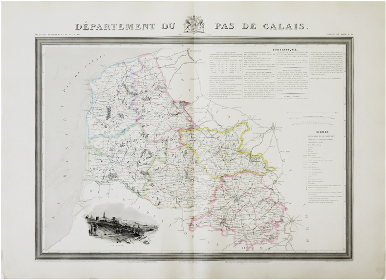
DONNET (Alexis) & FRÉMIN (Antoine-Rémy) & MONIN (Charles V.).
[PAS-de-CALAIS] Département du Pas de Calais.
Paris, Dusillion, 1841. 525x 675 mm.
书商的参考编号 : LBW-7270
|
|
|
DONNET (Alexis) & FRÉMIN (Antoine-Rémy).
[PYRÉNÉES-ORIENTALES] Département des Pyrénnées-Orientales.
Paris, Dusillion, 1841. 538x 663 mm.
书商的参考编号 : LBW-7272

|
|
|
DONNET (Alexis) & FRÉMIN (Antoine-Rémy).
[PYRÉNÉES-ATLANTIQUES] Département des Basses Pyrennées.
Paris, Dusillion, 1841. 533x 663 mm.
书商的参考编号 : LBW-7271

|
|
|
DONNET (Alexis) & FRÉMIN (Antoine-Rémy).
[SAÔNE-et-LOIRE] Département de Saône et Loire.
Paris, Dusillion, 1841. 523x 665 mm.
书商的参考编号 : LBW-7273

|
|
|
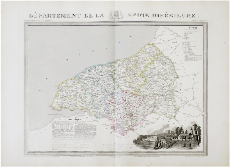
DONNET (Alexis) & FRÉMIN (Antoine-Rémy) & MONIN (Charles V.).
[SEINE-MARITIME] Département de la Seine Inférieure.
Paris, Dusillion, 1841. 522 x 656 mm.
书商的参考编号 : LBW-7274
|
|
|
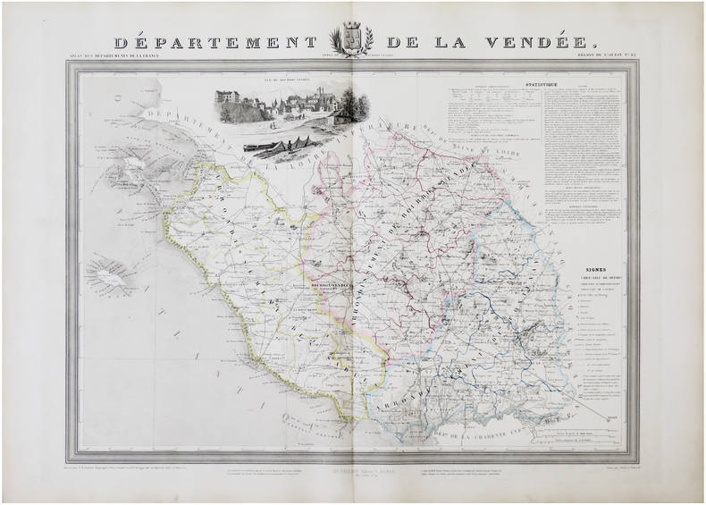
DONNET (Alexis) & FRÉMIN (Antoine-Rémy).
[VENDÉE] Département de la Vendée.
Paris, Dusillion, 1841. 532 x 671 mm.
书商的参考编号 : LBW-7276
|
|
|
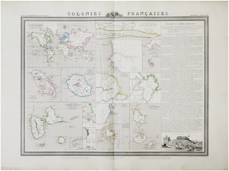
DONNET (Alexis) & FRÉMIN (Antoine-Rémy) & LEVASSEUR (Victor).
Colonies françaises.
Paris, Dusillion, 1841. 515 x 654 mm.
书商的参考编号 : LBW-7277
|
|
|
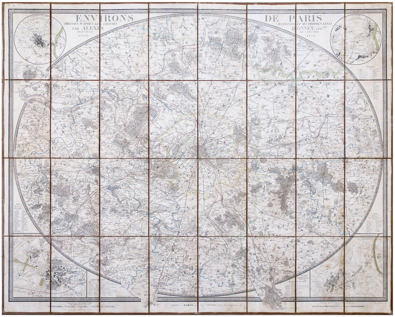
DONNET (Alexis).
Environs de Paris, dressés d'après les Chasses, D. Coutans, et ses propres levés.
Paris, Aug.te Logerot, 1850. En 28 sections montées sur toile et pliées, formant une carte de 770 x 940 mm ; étiquette au dos de l'éditeur parisien Heuguet.
书商的参考编号 : LBW-6848
|
|
|
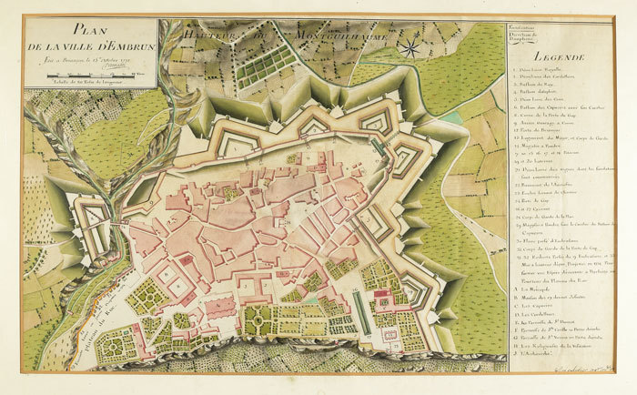
DONNADEI & SORBIER. MANUSCRIT.
Plan de la ville d’Embrun.
Briançon, 1771. 444 x 730 mm.
书商的参考编号 : LBW-779
|
|
|
DON R S edits David Gentleman wood engravings Asgeir Scott decorations Edward Ardizzone illustrations and Sheila Waters maps
Wine List Decorations 1961-1963 Specially Bound Edition
John Harvey Bristol No date 1964. 1st Edition. HARDCOVER. Large 8vo in black leather backed decorated cloth covered boards gilt lettering to spine top edge gilt 100pp on variously coloured leaves. This is one of a very small number of finely bound copies issued without a dust jacket . . . . . . . . . .CONDITION : An extremely well preserved almost AS NEW copy top edge of page block slightly dusty. . . . . . . . . . We always ship in PROTECTIVE CARD PARCELS John Harvey, Bristol hardcover
书商的参考编号 : T16N1966

|
|
|
Donald, J.R.
The Cape Breton Coal Problem
178 pages. At the behest of the Federal Minister of Finance (Mitchell Sharp), this volume presents the results of an investigation into the Cape Breton Coal Problem plus recommended policies which might be appropriate to the situation. Confirms the steadily increasing amount of subsidy required to support the Cape Breton coal industry and stresses the urgency of adopting and implementing new policies. Contains illustrations, maps and graphs. Prior owner's signature and date upon title page. Minimal marginalia and underlining in blue ball point pen. Average wear overall with top of spine open. Book
|
|
|
Donvez, Jacques & Mills, Hugh
Paris
No marks or inscriptions. No creasing to covers or to spine. A very clean copy with bright unmarked boards and no bumping to corners. 64pp. Introduction in English and French. Colour photograhs with dual language captions of Paris around 1951.

|
|
|
Doré Gustave:
Gustave Doré - 15 tableaux de la Sainte Russie.
2024, 2019. 15 cartes postales dans leur étui et emballage d'origine, donc à l'état de neuf.
书商的参考编号 : 24062

|
|
|
DORE Robert , LEONARD Emile G.
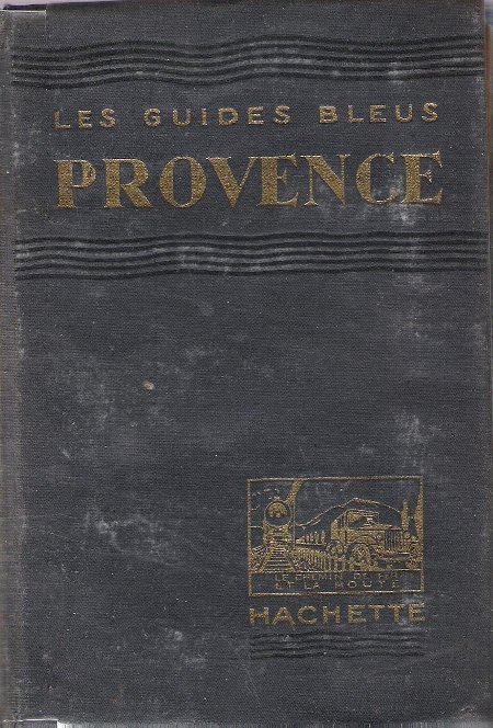
Les Guides Bleus : Provence . Complet De Ses Cartes Dépliantes En Couleurs
Paris Librairie Hachette 1933 In 16 Collection " Les Guides Bleus " . Excursions , nombreux plans de voyage et de villes en couleurs et noir et blanc . Une grande carte dépliante en fin d'ouvrage . Index . Cartes et Plans .- 510 p. + plans , 550 gr.
书商的参考编号 : 012341
|
|
|
Doran Adelaide LeMert; Maps Illustrator
The Ranch That Was Robbins': Santa Catalina Island
Arthur H. Clark Company 1963-01-01. Paperback. Very Good. From the personal library of noted historian John Caughey a John & Laree Caughey bookplate is affixed to the FFEP. Text and images are clean and unmarked. Illustrated wrapper shows some light wear faint rubbing along edges at spine a touch of toning on the spine. Arthur H. Clark Company paperback
书商的参考编号 : CHAPDOR11217
|
|
|
DORE Robert , LEONARD Emile G.
Les Guides Bleus : Provence . Complet De Ses Cartes Dépliantes En Couleurs
Collection " Les Guides Bleus " . Excursions , nombreux plans de voyage et de villes en couleurs et noir et blanc . Une grande carte dépliante en fin d'ouvrage . Index . Cartes et Plans .- 510 p. + plans , 550 gr.
|
|
|
Dore, R.N.
Cheshire
Ex-library book with usual marks and stamps. A very clean very tight copy with bright unmarked boards and no bumping to corners. Dust jacket not price clipped or marked or torn or creased with minor traces of storage. 192pp. A study of the County of Cheshire based on the old pre-1974 boundaries.

|
|
|
Dorin, Patrick C.
The Canadian National Railways' Story
206 pages including index. An operational and geographical study of the Canadian National and its equipment from its formation in 1919 through 1975. Told with knowledgeable text and over 400 fine black and white photos, maps and equipment rosters, enough to thrill and delight the hearts of al railroaders and railroad fans. Light wear to clean unmarked book. Dust jacket is price-clipped, moderately worn and bears several small tears each under one quarter inch in length. Very nice copy. Book
|
|
|
Doris B. Holleb; Illustrator 9 b/w Figures including maps
Social & Economic Information for Urban Planning
Center for Urban Studies of The University of Chicago 1970. Paperback. Very Good. very good paperback rubbing to spine no markings of any kind Center for Urban Studies of The University of Chicago paperback
书商的参考编号 : 77815
|
|
|
Dorling Kindersley Publishing Staff; Hema Maps Staff
Concise Atlas of the World
Dorling Kindersley Publishing Incorporated 2001. Hardcover. Good. Disclaimer:A copy that has been read but remains in clean condition. All pages are intact and the cover is intact. The spine may show signs of wear. Pages can include limited notes and highlighting and the copy can include previous owner inscriptions. At ThriftBooks our motto is: Read More Spend Less.Dust jacket quality is not guaranteed. Dorling Kindersley Publishing, Incorporated hardcover
书商的参考编号 : G0789480026I3N00 ???????? : 0789480026 9780789480026

|
|
|
Dotremont/Butor
CARTES ET LETTRES.CORRESPONDANCE 1966-1979.
Galilée.1986.In-8,couv.ill.Dessin et dédicace d'Alechinsky.TBE.Ex-libris.
书商的参考编号 : 49929
|
|
|
Douglas Sir Robert K.; Maps Illustrator
Europe and the Far East
The University Press 1904-01-01. Hardcover. Good. The University Press hardcover
书商的参考编号 : 170125039
|
|
|
Douglas WAB./Greenhous Brereton/Constable William maps W. A.
Out of the Shadows: Canada in the Second World War
Toronto: Oxford University Press 1977. 1st printing. Fine/Fine. 288 p. photos illus maps notes biblio index 8vo; Oxford University Press hardcover
书商的参考编号 : 32596 ???????? : 019540257X 9780195402575
|
|
|
Douglas Botting A. Spark maps Janet Chandler Sketches
Island of the Dragon's Blood
New York: Wilfred Funk inc. 1958. Hardbound. GOOD. Ex-library with dust jacket in protective cover. Tight bright clean and square except for expected library markings.1956 Oxford University expedition to the island of Socotra to record specimens of the native flora and fauna make recordings of the native language and collect archaeological artifacts. Socotra Soqotra is a small island archipelago off the Horn of Africa in the Indian Ocean currently controlled by Yemen designated a World Heritage Site by UNESCO in 2008. 1.5 Wilfred Funk inc. hardcover
书商的参考编号 : 6-3T017
|
|
|
DOWNIE (Murdo).
[ÉCOSSE] Carte particulière de la côte orientale d'Écosse depuis S.t Abb's Head jusqu'à Duncansby Head.
[Paris] Dépôt Général de la Marine, 1803. 883 x 609 mm.
书商的参考编号 : LBW-7579

|
|
|
Dowdey Clifford; Photos and maps by Samuel H. Bryant
Lee
Little Brown 1965. Stated first edition. Hardcover. very good/fine. NOT an ex library book. Prior owner sea on half title page. Clean interior pages with map endpapers. . Dust jacket has no chips some fade of yellow background on spine. Little, Brown hardcover
书商的参考编号 : 309624
|
|
|
Dowdey Clifford; Bryant Samuel H. photographs and maps by
Lee
Boston and Toronto: Little Brown and Company 1965. First Edition. Hardcover. Octavo; pp 781; VG-/G; ivory spine with burgundy and black text; dust jacket has slight sunning to exterior mylar wraps; cloth has slight wear to exterior and corners strong boards; text block has some foxing to exterior edges previous owner's book plate to front pastedown; interior clean. Shelved Rockville Bookstore. <br/><br/> Little, Brown and Company hardcover
书商的参考编号 : 7-83-1307821
|
|
|
DOWDEY CLIFFORD; BRYANT SAMUEL H. MAPS
Lee Takes Command
Barnes & Noble Books New York: 1994. Hardcover with dustjacket. Very good condition. Originally published as The Seven Days: The Emergence of Robert E. Lee. In this definitive account of the emergence of Robert E. Lee Clifford Dowdey proves that Lee's aggressive military strategy - reduced to the simplest truism "a good offense is the best defense" - made the Seven Days Battle the single most significant military engagement of the war. Lee's leadership of the Confederate Army over the next three years placed him among the world's great commanders. Includes an Index. ISBN: 1566194555. Barnes & Noble Books, New York: 1994 hardcover
书商的参考编号 : 47199X1 ???????? : 1566194555 9781566194556
|
|
 ?????????
 ?????PDF???
 RSS feed


