|
DIAZ (Gérard).
Carte de voeux illustrée d'une gravure originale signée.
Paris Société des peintres-graveurs français 1995 1 vol. Broché Carte de voeux dépliante sur Arches illustrée d'une eau-forte en couleurs (diamètre 13 cm) signée par Gérard Diaz. En parfait état.
書籍販売業者の参照番号
: 109107
|
|
|
DIAZ (Gérard).
Menu illustré d'une gravure originale signée.
Paris Les Amis du livre contemporain et Automobile-Club de France 1993 1 vol. Broché Menu dépliant sur Arches illustré d'une eau-forte (27 x 21 cm) dédicacée par Gérard Diaz et justifiée 9/100. En parfait état.
書籍販売業者の参照番号
: 109109
|
|
|
DIAZ (Gérard).
Menu illustré d'une gravure originale signée.
Paris Les Amis du livre contemporain et Automobile-Club de France 1993 1 vol. Broché Menu dépliant sur Arches illustré d'une eau-forte (27 x 21 cm) dédicacée par Gérard Diaz et justifiée 9/100. En parfait état.
書籍販売業者の参照番号
: 109109
|
|
|
DIAZ (Gérard)
Menu illustré d'une gravure originale signée.
Paris Société Les Amis Bibliophiles 1985 1 vol. Broché Menu dépliant sur Arches illustré d'une eau-forte (11.5 x 6.5 cm) signée par Gérard Diaz. En parfait état.
書籍販売業者の参照番号
: 109142
|
|
|
DIAZ (Gérard)
Menu illustré d'une gravure originale signée.
Paris Société Les Amis Bibliophiles 1985 1 vol. Broché Menu dépliant sur Arches illustré d'une eau-forte (11.5 x 6.5 cm) signée par Gérard Diaz. En parfait état.
書籍販売業者の参照番号
: 109142
|
|
|
Diana Pe. Maps By Stephen Good
East Sussex Church Walks. 30 Walks to 70 Churches
London England: Pe Publishing. Very Good. 2009. 1st Paperback Edition. Soft Cover. 8vo - over 7�" - 9�" Tall Octavo 9780954369033 Softcover Softcover East Sussex Church Walks. 30 Walks to 70 Churches by Diana Pe. Maps By Stephen Good. We carry a wide selection of titles in The Arts Theology History Politics Social and Physical Sciences. academic and scholarly books and Modern First Editions Reference books and all types of Academic Literature. . Pe Publishing paperback
書籍販売業者の参照番号
: 104270 ISBN : 0954369033 9780954369033
|
|
|
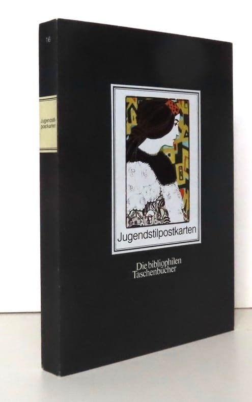
Dichand Hans:
Jugendstilpostkarten Die bibliophilen Taschenbücher.
Dortmund, Harenberg-Kommunikation, 1984 Carnet de cartes postales au format. . . carte postale. Infime trace de pli au second plat, pour le reste à l'état de neuf.
書籍販売業者の参照番号
: 20486
|
|
|
Dick Russell with maps by Eben given
EYE OF THE WHALE Epic Passage from Baja to Siberia
Simon & Schuster New York - ISBN:0684866080 2001 hardcover with dust jacket Twenty full-color photographs maps few b&w illustrations bibliography and index. Blue felt pen mark to bottom of pages. VERY GOOD book in VERY GOOD unclipped dust jacket This book shows the life-changing effect the gray whale has had upon people past and present - whalers hunters marine scientists whale watchers and even businessmen - who have looked into the eye of a whale and have come away transformed. Over the course of this astonishing book the gray whale emerges as a millennial metaphor mirroring a host of ecological political and social issues concerning our relationship with nature. A true story. Simon & Schuster, New York - ISBN:0684866080 hardcover
書籍販売業者の参照番号
: 2631 ISBN : 0684866080 9780684866086

|
|
|
Dickens, AG
The East Riding of Yorkshire with Hull and York
No marks or inscriptions. No creasing to covers or to spine. A lovely clean crisp very tight copy with bright boards and no bumping to corners. Slight browing to page edges. No dust jacket. 131pp. With twenty four black and white photographs. A character sketch of the old East Riding covering the land East of York, Malton and Selby, north of the Humber and reaching up to Filey on the coast.

|
|
|
Dickens, Charles
Nicholas Nickleby: Volume I
511 pages, illustrated, introduction by George Gissing, page edges foxed, top page edges gilt. eng
|
|
|
Dickens, Charles
Nicholas Nickleby: Volume II
viii,499 pages, illustrated by R.J. Williams, introduction by George Gissing, notes by F.G. Kitton, page edges foxed, top page edges gilt. eng
|
|
|
Didier Richard Maps
Pays du Mont-Blanc-Beaufortain, Avavis-Val D'Arly (FRANCAIS) Carte – Carte pliée, décembre 1997
Institut Geographique National (décembre 1997)
書籍販売業者の参照番号
: lc_10774
|
|
|
DIEULEFILS P.-
Carte postale annonce: Les Mangeurs de Poux en Famille. Tonkin. Hanoï. 659.-
La partie droite laissée libre de cette carte postale est utilisée à une annonce intitulée Étrennes utiles, proposant un joli album gratuit à tout acheteur d'une collection de 100 cartes postales au prix de 13 francs ou 6 piastres...Le petit mot adressé à un collectionneur précise qu'il s'agit de sa nouvelle collection. Hanoï. Photographie Dieulefils. Non datée, sans doute expédiée sous enveloppe. Carte postale (140 x90mm), cliché de 81 x 55mm, très net. Bel état.
書籍販売業者の参照番号
: ORD-3163
|
|
|
DIERKENS Alain
Inventaires des cartes, plans et registres divers (fin XIXe - début XXe siècle).
Bruxelles, Archives Générales du Royaume, 1980. 20 x 29, 55 pp., broché, très bon état.
書籍販売業者の参照番号
: 21894
|
|
|
DIEPPE. MANUSCRIT.
Plan de Dieppe.
1730. 600 x 905 mm.
書籍販売業者の参照番号
: LBW-4156

|
|
|
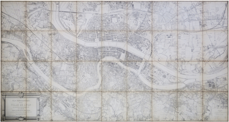
DIGNOSCYO (Laurent de) & DIGNOSCYO (Claude de).
[LYON] Plan topographique de la ville de Lyon levé et dressé en 1863 par M.M.rs Dignoscyo père et fils, révisé en 1883-1884.
1886. En 36 sections montées sur toile et repliées, formant un plan de 1,12 x 2,12 m.
書籍販売業者の参照番号
: LBW-8141
|
|
|
DIJON SUD-EST
Carte au 1/80 000e.
Une feuille 53,5x34,5 cm.
|
|
|
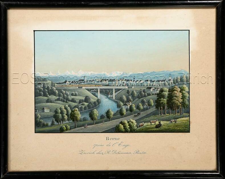
Dikenman, Johann Rudolf (1832-1888):
Berne prise de l'Enge.
Zürich, chez R. Dikenman, Peintre, um 1857. Kol. Aquatinta. Bildgrösse: 7,5 x 11,2 cm. Blattgrösse: 13 x 16 cm.
書籍販売業者の参照番号
: 595BG
|
|
|
Dikenman, Johann Rudolf (1832-1888)
Berne prise de l'Enge.
Zürich, chez R. Dikenman, Peintre, um 1857. Kol. Aquatinta. Bildgrösse: 7,5 x 11,2 cm. Blattgrösse: 13 x 16 cm. + Wichtig: Für unsere Kunden in der EU erfolgt der Versand alle 14 Tage verzollt ab Deutschland / Postbank-Konto in Deutschland vorhanden +, Bild
書籍販売業者の参照番号
: 595BG

|
|
|
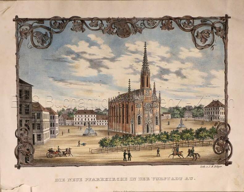
Dilger, J.B.:
Die neue Pfarrkirche in der Vorstadt Au (heute in München).
(München, Jesef Deschler Verlag, um 1940. Altkolorierte Lithographie. Bildgrösse: 14,5 x 21,5 cm. Blattgrösse: 19 x 24 cm.
書籍販売業者の参照番号
: 769CG
|
|
|
Dilger, J.B
Die neue Pfarrkirche in der Vorstadt Au (heute in München).
(München, Jesef Deschler Verlag, um 1940. Altkolorierte Lithographie. Bildgrösse: 14,5 x 21,5 cm. Blattgrösse: 19 x 24 cm. + Wichtig: Für unsere Kunden in der EU erfolgt der Versand alle 14 Tage verzollt ab Deutschland / Postbank-Konto in Deutschland vorhanden +, Abb.
書籍販売業者の参照番号
: 769CG

|
|
|
Dino Maps
USA Children's 38x54
2008-01-01. New. Ships with Tracking Number! INTERNATIONAL WORLDWIDE Shipping available. May be re-issue. Buy with confidence excellent customer service! unknown
書籍販売業者の参照番号
: 1905502079n ISBN : 1905502079 9781905502073

|
|
|
Dino Maps
USA Children's 38x54
2008-01-01. Good. Ships with Tracking Number! INTERNATIONAL WORLDWIDE Shipping available. May not contain Access Codes or Supplements. May be re-issue. May be ex-library. Shipping & Handling by region. Buy with confidence excellent customer service! unknown
書籍販売業者の参照番号
: 1905502079 ISBN : 1905502079 9781905502073

|
|
|
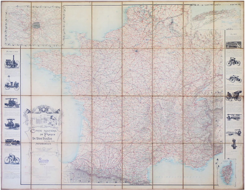
DION BOUTON.
Carte routière de France de Dion Bouton spéciale pour automobiles.
Paris, J. Barreau, 1900. En 32 sections montées sur toile et repliées, formant une carte de 1,28 x 1,56 m.
書籍販売業者の参照番号
: LBW-7922
|
|
|
DIRECCION de HIDROGRAFIA;
[NICARAGUA] Costa de Mosquitos - Puerto y boca del rio de S. Juan de Nicaragua.
1818 184 x 261 mm.
書籍販売業者の参照番号
: LBW02e4a

|
|
|
DIRICKX Frères
Commémoration du Centenaire de la Belgique (1830-1930), album souvenir de l'Exposition internationale d'Anvers, 1930/Herdenking van Belgïe's Eeuwfeest (1830-1930), Gedenk-album der Wereldtentoonstelling, Antwerpen 1930.
Anvers, Dirickx Frères, 1930. 20 x 15, sans pagination, plusieurs illustrations, cartonnage d'édition imprimé, bon état.
書籍販売業者の参照番号
: 28016
|
|
|
Directorate of Fisheries Research
Atlas of the Seas Around the British Isles
London: MINISTRy of Agriculture Fisheries and Food 1981. unpaginated colour and b/w maps Original hardback binding spiral bound fine with minimal wear. Contents clean and tight small water mark to the endpaper no inscriptions. A near fine copy. First Edition. Hard Cover. Near Fine/No dust jacket. Folio. MINISTRy of Agriculture Fisheries and Food Hardcover
書籍販売業者の参照番号
: 022777 ISBN : 0907545009 9780907545002

|
|
|
Direzione Generale del Censo
Pianta Topografica di Roma pubblicata dalla Direzione Generale del Censo ed aggioranta a tutto il corrente anno MDCCCLXVI
Rara pianta della città, a proiezione verticale, orientata con il nord in alto.La pianta fu pubblicata per la prima volta nel 1829: "La pianta del Censo è senz'altro la più accurata e significativa pianta della Roma Papale nel sec. XIX. Gli edifici sono campiti a tratteggio; chiese e monumenti principali sono rappresentate con la pianta interna. L'orografia è chiaramente leggibile così come il disegno del verde. Ampia legenda sul lato sinistro ed in basso a destra elenco dei XIV rioni. È raffigurata la sola città entro il perimentro delle mura che risalta pertanto nitidamente sul fondo bianco. Il Cardinale Cesare Guerrieri, primo presidente della Congregazione dei Catasti (poi Censo) dal 1816 al 1832, fece incidere e pubblicare questa pianta, basandosi sulle mappe manoscritte del Catasto Urbano ordinate da PIO VII nel 1818 e completate nel 1822" (cfr. Marigliani p. 323). Una seconda stesura dell'opera viene alla luce nel 1854, ristampa delle lastre originali, che contiene l'indicazione del ponte di ferro costruito accanto a Ponte Rotto. La pianta fu poi definitivamente emendata nel 1866 - questa nostra edizione."E' la più accurata immagine della città subito prima che diventasse capitale. Compare il ponte di ferro a San Giovanni dei Fiorentini (1863) ed è indicata la fabbrica dei tabacchi (1863) con l'antistante Piazza Matai (1864). Ci sono le linee ferroviarie a Termini (1862) mentre manca ovviamente il fabbricato die viaggiatori (1867). È riportato infine il primo tratto di via Nazionale (fino a via Quattro Fontane), tracciata proprio nel 1866" (cfr. Marigliani p. 411).Acquaforte, stampata da 4 lastre su altrettanti fogli di carta coeva, tagliati, applicati su tela e montati ad astuccio. Tela leggermente lesionata nelle pieghe, per il resto in buono stato di conservazione.Esemplare con ex-libris della libreria di Ulderico Bossi, che aveva sede in Roma a via del Corso 401.BibliografiaA. P. Frutaz, "Le piante di Roma", n. 191; C. Marigliani, "Le Piante di Roma delle collezioni private", n. 354; Scaccia Scarafoni, "Le Piante di Roma", n. 312. Rare map of the city, with vertical projection, oriented with the north at the top.The map was published for the first time in 1829, and is undoubtedly the most accurate and significant map of Papal Rome in the nineteenth century. Wide key-legend on the left side and at the bottom right list of the XIV districts. It is represented the only city within the perimeter of the walls that stands out clearly on the white background. Cardinal Cesare Guerrieri, first president of the Congregazione dei Catasti (later Censo) from 1816 to 1832, had this map engraved and published, based on the manuscript maps of the Catasto Urban ordered by PIO VII in 1818 and completed in 1822. A second issue of the map comes to light in 1854, reprint of the original plates, which contains the indication of the iron bridge built next to Ponte Rotto. The map was then definitively amended in 1866 - our edition.It is the most accurate image of the town just before it became capital of Italy. The iron bridge appears in San Giovanni dei Fiorentini (1863) and the tobacco factory (1863) is indicated with the opposite Piazza Matai (1864). There are the railway lines at Termini (1862) while the travellers' building (1867) is obviously missing. Finally, shows the first part of Via Nazionale, traced in 1866.Etching, printed from 4 plates on 4 sheets of contemporary paper, cut, applied on canvas and mounted in a box. Canvas slightly damaged in the folds, otherwise in good condition.Exemple with ex-libris of the book seller Ulderico Bossi, which was based in Rome in via del Corso 401.BibliografiaA. P. Frutaz, "Le piante di Roma", n. 191; C. Marigliani, "Le Piante di Roma delle collezioni private", n. 354; Scaccia Scarafoni, "Le Piante di Roma", n. 312. A. P. Frutaz, "Le piante di Roma", n. 191; C. Marigliani, "Le Piante di Roma delle collezioni private", n. 354; Scaccia Scarafoni, "Le Piante di Roma", n. 312.

|
|
|
Disney Walt:
Mickey Mouse - petite sérigraphie.
Christian Desbois, 1999. Rare petite sérigraphie au format 15 x 22, avec sa serpente muette. A l'état de neuf.
書籍販売業者の参照番号
: 828

|
|
|
Diverse
Brunn's Neuester Plan von München mit Hausnummern. Und Straßenverzeichnis.,Nymphenburg mit botanischem Garten. Angabe der Sehenswürdigkeiten.,
Brunn:München.0. 13 Seiten.19 cm x 12 cm. Originalbroschur
書籍販売業者の参照番号
: K42085

|
|
|
DIXON George.
Voyage autour du monde, et principalement à la côte nord-ouest de l'Amérique, fait en 1785, 1786, 1787 et 1788, à bord du King-George et de la Queen-Charlotte, par les capitaines Portock et Dixon. Traduit de l'anglois par M. Lebas.
Paris, chez Maradan, 1789. in-8 (20,5 x 13 cm), [6]-581 + [4]-292-46-[4] p. + h.-t. 2 vol. reliés époque , dos lisse avec titre , tomaison et nom du collectionneur en queue. Édition originale de la traduction française, cet exemplaire comporte bien les tables dépliantes à la fin du volume 2 mais compte 19/22 planches et cartes hors-texte (manquent 18, 21, 22). Marques d'usure aux reliures, plusieurs fentes aux mors, restaurations de papier à la p. de titre et la suivante dans le vol. 1, mouillure claire sur quelques ff. du vol. 2 et tache en marge haute des derniers ff. Sabin, 20366, Chadenat, n°1593
書籍販売業者の参照番号
: PHO-853
|
|
|
DM. and MA. Samuels ed. Abshire; Illustrator Maps & illus D. M. M. A.
Portuguese Africa; A Handbook
Pall Mall Press 1969. Hardcover. Very Good. Clean unmarked pages. Good binding and cover. Hardcover and dust jacket. Dust jacket is in mylar and has a large hole torn on the front. Ships daily. Pall Mall Press hardcover
書籍販売業者の参照番号
: 81251378
|
|
|
Doerflinger, Frederic
Slow Boat Through England
No marks or inscriptions. No creasing to covers or to spine. A lovely clean very tight copy with bright unmarked covers and no bumping to corners. 256pp.

|
|
|
DOETECUM Johannes van (Attivo tra il 1554 - 1606)
Totius Orbis Cogniti Universalis Descriptio
Magnifica mappa del mondo a doppio emisfero finemente incisa, incisa da Jan Van Doetecum per Paulus Merula nel 1605. La raffinata incisione di Van Doetcum si basa su una mappa di suo padre Baptista van Doetecum per Petrus Plancius nel 1590, con diversi importanti aggiornamenti, tra cui l'aggiunta della recentemente esplorata Nova Zemlya (esplorata da Barentsz durante i suoi 3 viaggi nelle regioni artiche alla ricerca del “Passaggio a Nord-Est”) e l'aggiunta di due emisferi celesti, basati sulla mappa del mondo di Plancius del 1594. La mappa aggiunge, agli angoli, l’ingrandimento di 4 isole, Giappone, Isola, Ceylon e Sant'Elena. Include le quattro grandi isole dell'Artico, così come appaiono sullemappa di Mercatore del 1595. Il “Passaggio a Nord-Ovest” è aperto e chiaramente definito, permettendo un passaggio attraverso lo Stretto di Anian nel Pacifico verso l'Atlantico. California e Quivira sono nominati, insieme alle annotazioni sulla scoperta dell'America da parte di Colombo nel 1492 e alle note sulle regioni settentrionali conosciute e sconosciute dell'America. L'enorme continente meridionale è chiamato Magellanica, Terra Australis, e anche Terra del Fuoco, prima del viaggio di Le Maire e Schouten che avrebbe iniziato a riscrivere la credenza allora prevalente che lo stretto scoperto da Ferdinando Magellano fosse l'unico passaggio d'acqua tra l'Atlantico e l'Oceano Pacifico nell'emisfero meridionale. Viene mostrata una massiccia Guinea Nova, senza alcun segno delle moderne scoperte in Australia e Nuova Zelanda, con i resti delle informazioni di Marco Polo ancora presenti nella regione. C'è una prima apparizione delle Filippine (I. Filipinae). La costa cinese, pur essendo ricca di informazioni, precede la comparsa della Corea e fornisce una presentazione molto curiosa del Giappone. La mappa è riccamente impreziosita da decorazioni di velieri, che riflettono la mano del maestro incisore caratteristica della famiglia Van Doetcum, allora forse i migliori incisori impegnati attivamente nella realizzazione di mappe commerciali. Acquaforte e bulino, in ottimo stato di conservazione. Magnifico esemplare. Striking dark impression of this finely engraved double hemisphere map of the World, engraved by Jan Van Doetecum for Paulus Merula in 1605. Van Doetcum's fine engraving his based upon a map engraved by his father Baptista van Doetecum for Petrus Plancius in 1590, with several important updates, including the addition of the recently explored Nova Zemlya (explored by Barentsz during his 3 voyages to the arctic regions in search of the Northeast Passage) and the addition of two celestial hemispheres, based upon Plancius' world map of 1594. The map also adds fine large format images of 4 islands, Japan, Island, Ceylon and St. Helena, presenting fine enlargements of these islands as they appearon the map. The map includes the four large islands in the Arctic, as they appeared on Mercator's maps, including his very rare 1595 map of the Polar Regions. The Northwest Passage is open and clearly defined, allowing a passage via the Straits of Anian in the Pacific to the Atlantic. California and Quivira are named, along with annotations on the discovery of America by Columbus in 1492 and notes on the known and unknown northern regions of America. The massive southern continent is called Magellanica, Terra Australis, and also Terra del Fuego, pre-dating the voyage of Le Maire and Schouten which would begin to re-write the then prevailing belief that the strait discovered by Ferdinand Magellan was the only water passage from between the Atlantic and Pacific Ocean in the Southern Hemisphere. A massive Nova Guinea is shown, with no signs of the modern discoveries in Australia and New Zealand, with remnants of the information from Marco Polo still present in the region (Beach). There is an early appearance of the Philippines (I. Filipinae). The Chinese coastline, while filled with information, pre-dates the appearance of Korea and provides a very curious presentation of Japan. The map is richly embellished with strapwork decorations and sailing ships, reflecting the master-engraver's hand characteristic of the Van Doetcum family, which were then perhaps the finest engravers actively engaged in commercial map making. Etching with engraving, very good condition. R. W. Shirley, "The Mapping of the world", 254; New Hollstein, Doetecum IV, 995

|
|
|
DOLLFUS (Gustave-Frédéric) & BIGOT (Alexandre) & THOMAS (H.).
[PARIS/GÉOLOGIE] Carte topographique de l'État-Major. Carte géologique générale. Paris au 320,000e. Feuille n°13.
1852-1892. En 21 sections montées sur toile et repliées, formant une carte de 667 x 937 mm ; étiquette au dos de l'éditeur Baudry et Cie portant le titre.
書籍販売業者の参照番号
: LBW-8262

|
|
|
DOMENY DE RIENZI Grégoire Louis:
Océanie ou cinquième partie du monde. Revue géographique et ethnographique de la Malaisie, de la Micronésie, de la Polynésie et de la Mélanésie; offrant les résultats des voyages et des découvertes de l'auteur et de ses devanciers, ainsi que ses nouvelles classifications et divisions de ces contrées.
Paris, Firmin Didot frères, 1836-1837. 3 volumes in-8 de [4]-399-[3]; [4]-397-[3]; [4]-635-[5] pages demi-chagrin rouges, dos lisses ornés de filets et fleurons dorés, tranches marbrées.
書籍販売業者の参照番号
: 21048
|
|
|
Dominic Beddow Collins Maps
Discovering Edinburgh Illustrated Map
Sheet map. New. Edinburgh home to the Scottish Parliament is on the itinerary of many visitors to Scotland. This brand new edition retains the delightful water-colour mapping with individual paintings of all the main sights and landmarks. Popular areas at larger scale hundreds of shops restaurants cafes and b unknown
書籍販売業者の参照番号
: ria9780008320386_new ISBN : 0008320381 9780008320386

|
|
|
Dominic Beddow Collins Maps
Discovering Edinburgh Illustrated Map
Sheet map. As New. Edinburgh home to the Scottish Parliament is on the itinerary of many visitors to Scotland. This brand new edition retains the delightful water-colour mapping with individual paintings of all the main sights and landmarks. Popular areas at larger scale hundreds of shops restaurants cafes and b unknown
書籍販売業者の参照番号
: ria9780008320386_rkm ISBN : 0008320381 9780008320386
|
|
|
DONNET (Alexis) & FRÉMIN (Antoine-Rémy).
[CÔTES d'ARMOR] Département des Côtes du Nord.
Paris, Dusillion, 1841. 534 x 662 mm.
書籍販売業者の参照番号
: LBW-7259

|
|
|
DONNET (Alexis) & FRÉMIN (Antoine-Rémy).
[DOUBS] Département du Doubs.
Paris, Dusillion, 1841. 525 x 662 mm.
書籍販売業者の参照番号
: LBW-7260

|
|
|
DONNET (Alexis) & FRÉMIN (Antoine-Rémy).
[GERS] Département du Gers.
Paris, Dusillion, 1841. 531x 655 mm.
書籍販売業者の参照番号
: LBW-7261

|
|
|
DONNET (Alexis) & FRÉMIN (Antoine-Rémy) & MONIN (Charles V.).
[GIRONDE] Départ.t de la Gironde.
Paris, Dusillion, 1841. 693x 506 mm.
書籍販売業者の参照番号
: LBW-7262

|
|
|
DONNET (Alexis) & FRÉMIN (Antoine-Rémy).
[HAUTE-MARNE] Département de la Haute Marne.
Paris, Dusillion, 1841. 704x 498 mm.
書籍販売業者の参照番号
: LBW-7266

|
|
|
DONNET (Alexis) & FRÉMIN (Antoine-Rémy).
[ISÈRE] Département de l'Isère.
Paris, Dusillion, 1841. 525x 665 mm.
書籍販売業者の参照番号
: LBW-7263

|
|
|
DONNET (Alexis) & FRÉMIN (Antoine-Rémy).
[LANDES] Département des Landes.
Paris, Dusillion, 1841. 555x 661 mm.
書籍販売業者の参照番号
: LBW-7264

|
|
|
DONNET (Alexis) & FRÉMIN (Antoine-Rémy).
[MAYENNE] Département de la Mayenne.
Paris, Dusillion, 1841. 530 x 667 mm.
書籍販売業者の参照番号
: LBW-7267

|
|
|
DONNET (Alexis) & FRÉMIN (Antoine-Rémy).
[MORBIHAN] Département du Morbihan.
Paris, Dusillion, 1841. 524 x 664 mm.
書籍販売業者の参照番号
: LBW-7268

|
|
|
DONNET (Alexis) & FRÉMIN (Antoine-Rémy).
[MOSELLE] Département de la Moselle.
Paris, Dusillion, 1841. 546x 662 mm.
書籍販売業者の参照番号
: LBW-7269

|
|
|
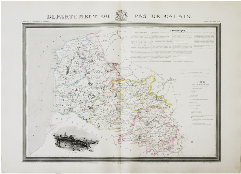
DONNET (Alexis) & FRÉMIN (Antoine-Rémy) & MONIN (Charles V.).
[PAS-de-CALAIS] Département du Pas de Calais.
Paris, Dusillion, 1841. 525x 675 mm.
書籍販売業者の参照番号
: LBW-7270
|
|
|
DONNET (Alexis) & FRÉMIN (Antoine-Rémy).
[PYRÉNÉES-ATLANTIQUES] Département des Basses Pyrennées.
Paris, Dusillion, 1841. 533x 663 mm.
書籍販売業者の参照番号
: LBW-7271

|
|
 検索結果のメールを受信する
 PDFファイルの検索結果をダウンロード
 RSSフィード


