|
DUMONT (Jean).
[SAINT-OMER] St. Omer en Artois avec les forts des environs.
La Haye, Pierre Husson, 1720. 359 x 471 mm.
书商的参考编号 : LBW0621d

|
|
|
DUMONT (Jean);
[SAINT-VENANT] St. Venant assiégé & pris en 1710 par le Pr. d'Orange.
La Haye Pierre Husson 1720 401 x 461 mm.
书商的参考编号 : LBW06219

|
|
|
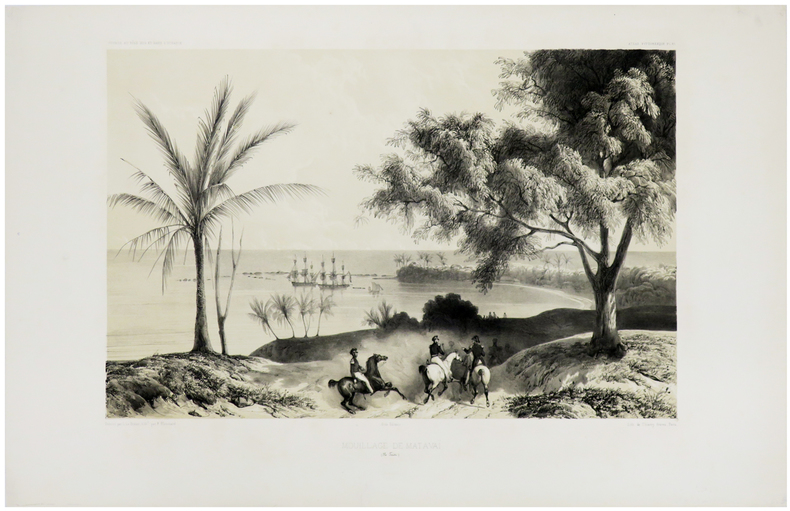
DUMONT D'URVILLE (Jules-Sébastien-César) & LE BRETON (Louis).
[TAHITI] Mouillage de Matavaï (Ile Taïti).
Paris, [1841-1854]. 290 x 400 mm.
书商的参考编号 : LBW-1308
|
|
|
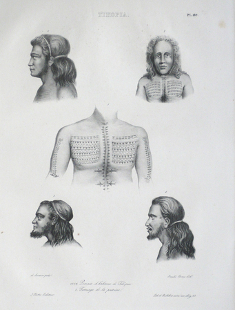
DUMONT D'URVILLE (Jules-Sébastien-César) & SAINSON (Louis-Auguste de).
[TIKOPIA] Tikopia.
[Paris, 1833]. 383 x 230 mm.
书商的参考编号 : LBW061a5
|
|
|
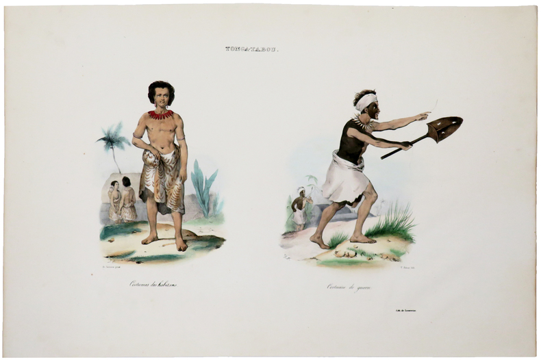
DUMONT D'URVILLE (Jules-Sébastien-César).
[ÎLES TONGA] Tonga-Tabou. Costumes des habitans - Costume de guerre.
[Paris, 1833]. 250 x 350 mm.
书商的参考编号 : LBW-5463
|
|
|
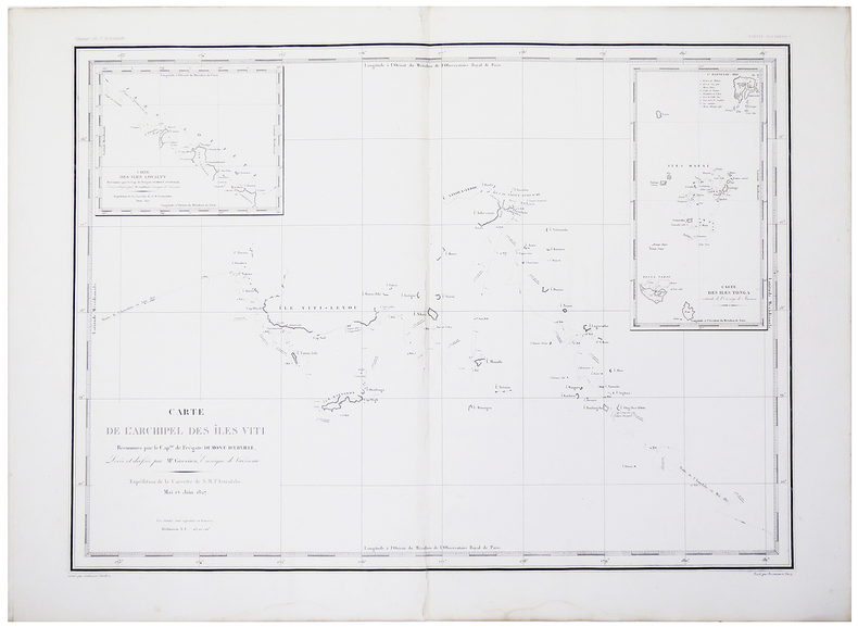
DUMONT D'URVILLE (Jules-Sébastien-César).
[ÎLES FIDJI] Carte de l'archipel des Îles Viti reconnues par le Cap.ne de frégate Dumont d'Urville.
[Paris, 1833]. 430 x 585 mm.
书商的参考编号 : LBW-5461
|
|
|
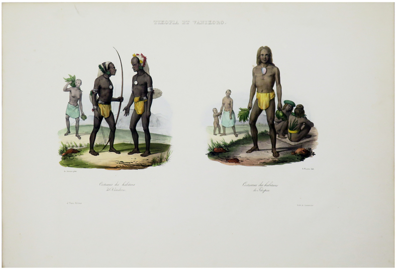
DUMONT D'URVILLE (Jules-Sébastien-César).
[ÎLES SALOMON] Tikopia et Vanikoro. Costumes des habitans de Vanikoro - Costumes des habitans de Tikopia.
[Paris, 1833]. 220 x 335 mm.
书商的参考编号 : LBW-5464
|
|
|
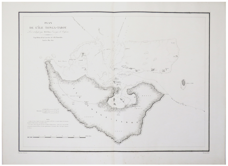
DUMONT D'URVILLE (Jules-Sébastien-César).
[ÎLES TONGA] Plan de l'île Tonga-Tabou levé et dressé par M.E. Pâris, enseigne de vaisseau.
[Paris, 1833]. 427 x 580 mm.
书商的参考编号 : LBW-5456
|
|
|
DUMONT D'URVILLE (Jules-Sébastien-César) & LE BRETON (Louis).
[ÎLES MARQUISES] L'Astrolabe et la Zélée. Arrivée à Noukahiva.
Paris et New-York, V.e Turgis, [1853]. 286 x 398 mm.
书商的参考编号 : LBW-8317

|
|
|
DUMESNIL, F.
Académie des jeux. Contenant le règles, principes et combinaisons des principaux jeux de cartes, des échecs, du billard, des dames, du dominos, du tric-trac, du jacquet, etc.
A PAris, Chez Bernardin-Béchet et Fils, Editeurs - Sans date - In-12, broché - 170 p.
书商的参考编号 : 110488
|
|
|
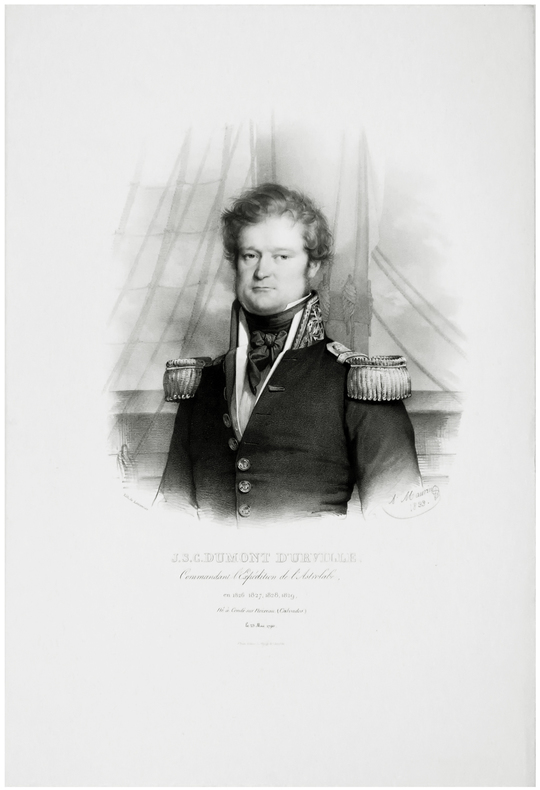
DUMONT D'URVILLE (Jules-Sébastien-César).
J.S.C. Dumont d'Urville, commandant l'expédition de l'Astrolabe, en 1826, 1827, 1828, 1829, né à Condé sur Noireau (Calvados) le 23 mai 1790.
[Paris, 1833]. 343 x 240 mm.
书商的参考编号 : LBW-5448
|
|
|
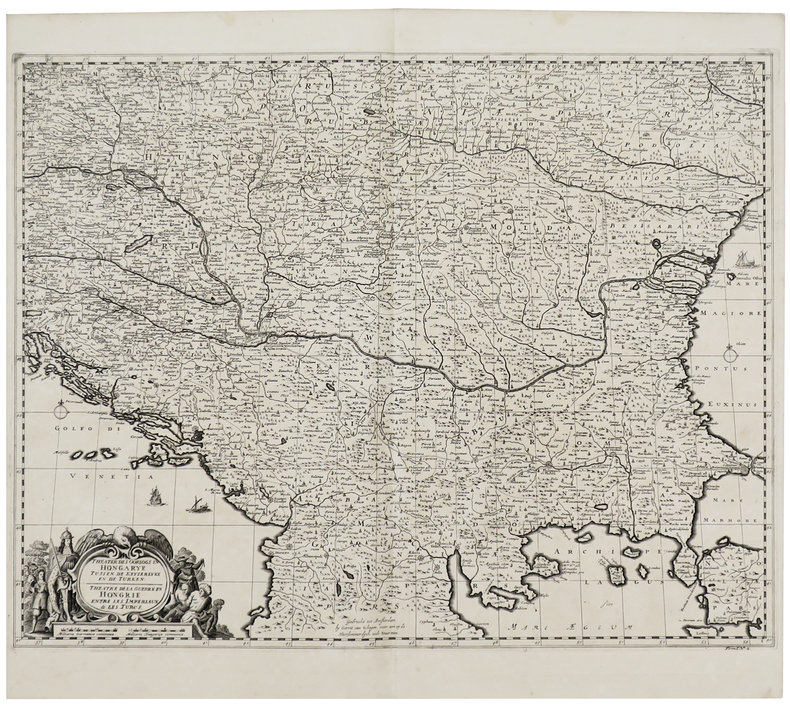
DUMONT (Jean).
Theater des oorlogs in Hongarye tussen de Keyserlyke en de Turken - Théâtre de la guerre en Hongrie entre les Impériaux & les Turcs.
[La Haye, Isaac van der Kloot, 1729] 452 x 583 mm.
书商的参考编号 : LBW-6098
|
|
|
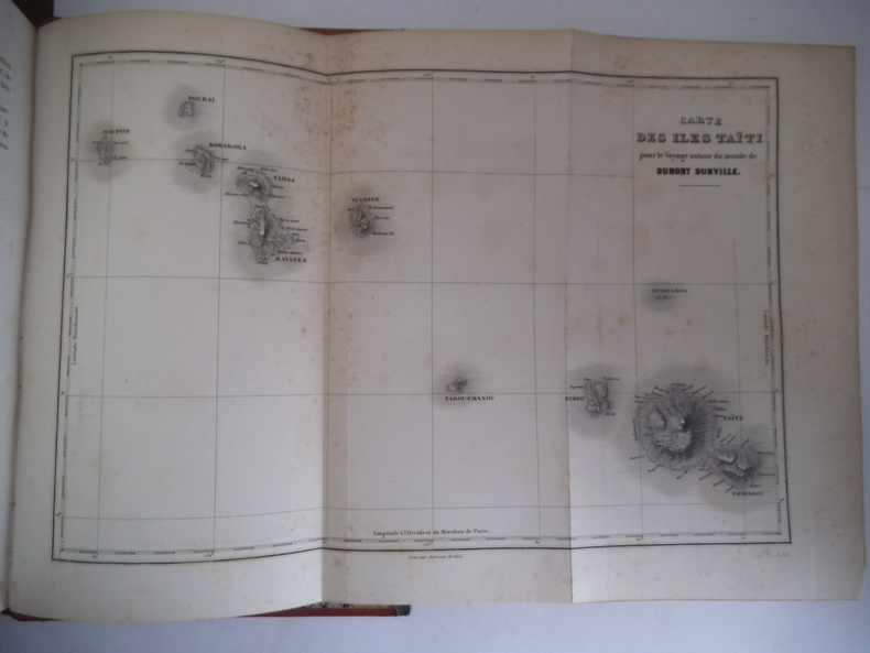
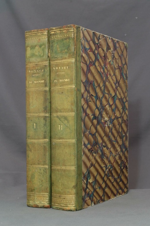
DUMONT D’ URVILLE
Voyage autour du monde.
Publié sous la direction du Contre Amiral DUMONT D’ URVILLE. Nouvelle édition revue, corrigée. Deux tomes en deux volumes in 4 demi-cuir rouge. Titre et caissons dorés. Larges filets à froid sur les plats. Tome1 : faux-titre, frontispice gravé, sous serpente, titre XI, 550 pages, 1 page de table des chapitres, tranches mouchetées. 21 gravures sur acier, hors-texte, sous serpente, y compris le frontispice, Une grande carte dépliante Tour du Monde. Furne & Cie 1848. Rousseurs, importantes, fortes à certaines pages ainsi qu’au verso de certaines gravures. Une mouillure à l’ange supérieur droit. Tome 2 : faux-titre, frontispice gravé sous serpente« mort du Capitaine COOK », 542 pages, 20 gravures sur acier, hors-texte , sous serpente, y compris le frontispice. Grande carte dépliante des Iles TAHITI pour les voyages autour du monde ; 1 page de table des chapitres. Rousseurs, fortes et concentrées à certaines pages, ainsi qu’au verso de certaines gravures. Furne et Cie 1848
书商的参考编号 : 9721
|
|
|
DUMONT D'URVILLE:
Voyage pittoresque autour du monde. Résumé général des voyages de découvertes de Magellan, Tasman, Dampier, Byron, Wallis, Carteret, Bougainville, Cook, Lapérouse, G. Bligh, Vancouver, d'Entrecasteaux, [...].
Paris, L. Tenré et Henri Dupuy, 1834. 2 volumes in-4 de [4]-VIII-576 et [4]-584 pages, demi-basane verte, dos lisses ornés de filets dorés, traces d'étiquette dans la partie supérieure des dos, petite fente à un mors, coiffes, coupes et coins frottés, premier cahier du tome second légèrement déboîté, avec une petite mouillure.
书商的参考编号 : 8783
|
|
|
DUMAS-VORZET Edmond
Paris 1867
- Librairie du Petit Journal, Paris 1867, 107,5x71cm, une feuille repliée. - First edition. Map of Paris divided in 20 arrondissements, wich were created in 1859. A very good copy with the 20 districts totally heightened in colors by a contemporary hand. The map is skillfully reinforced at the back. [FRENCH VERSION FOLLOWS] Edition originale. Plan de Paris divisé en 20 arrondissements, lesquels furent créés en 1859. Bel exemplaire avec les vingt quartiers entièrement aquarellés à l'époque. Carte habilement consolidée aux pliures du verso.

|
|
|
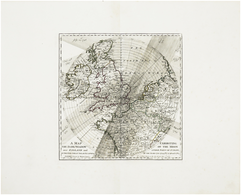
DUNN (Samuel) & MARTIN (Benjamin).
A Map exhibiting the dark shadow of the Moon over England and other parts of Europe, in the five great solar eclipses, of the years 1715, 1724, 1737, 1748 and 1764.
London, Robert Sayer, 1787 [1788]. 300 x 295 mm.
书商的参考编号 : LBW-6417
|
|
|
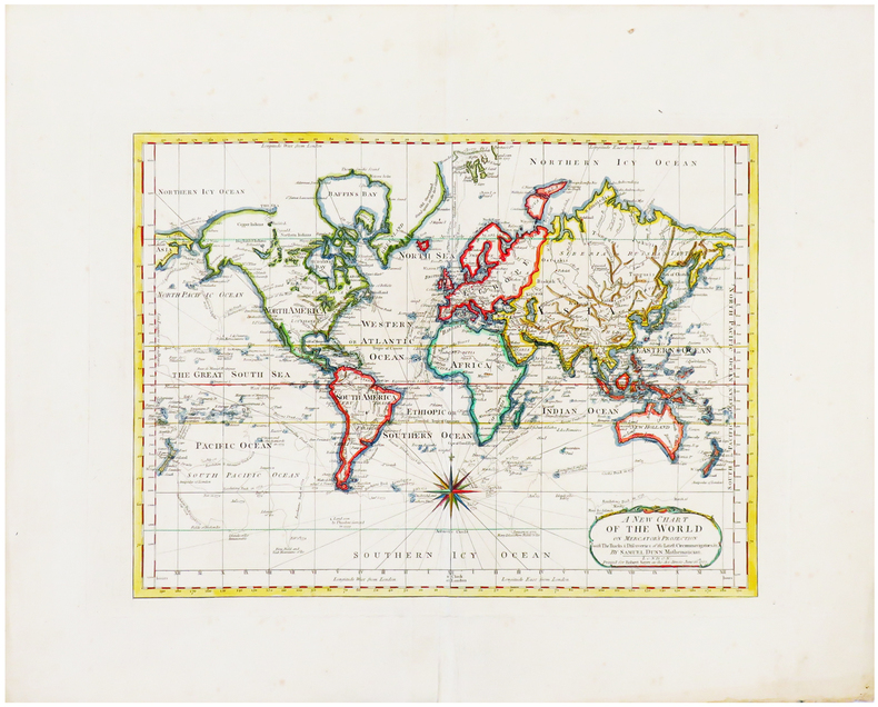
DUNN (Samuel).
A new Chart of the World on Mercator's projection with the tracks & discoveries of the latest circumnavigators &c.
London, Robert Sayer, 1787 [1788]? 304 x 410 mm.
书商的参考编号 : LBW-6653
|
|
|
DUNKERQUE. MANUSCRIT.
Carte de la côte de Dunkerque depuis Mardick jusques aux limites des Territoires Autrichiens.
1779. 330 x 532 mm, entoilée au XIXe et pliée.
书商的参考编号 : LBW-4096

|
|
|
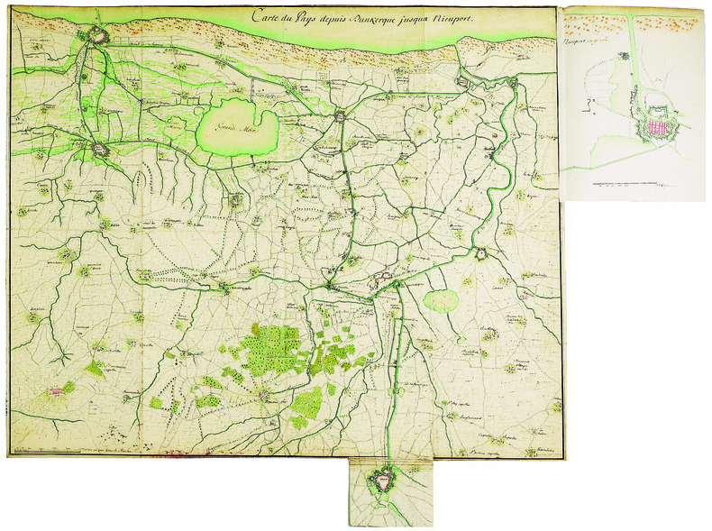
DUNKERQUE. MANUSCRIT.
Carte du pays depuis Dunkerque jusqua Nieuport.
[circa 1750]. 482 x 596 mm.
书商的参考编号 : LBW-4125
|
|
|
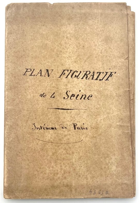
DUNAIME.
Plan figuratif de la Seine, intérieur de Paris.
, , 1833. Lithographie gravée sur papier fort d’environ 85 115 cm, colorié.
书商的参考编号 : 43437
|
|
|
Dundrum Maps & HarperCollins
All Ireland Road Atlas
HarperCollins 2012. Paperback. Acceptable. Disclaimer:A readable copy. All pages are intact and the cover is intact. Pages can include considerable notes-in pen or highlighter-but the notes cannot obscure the text. At ThriftBooks our motto is: Read More Spend Less.Dust jacket quality is not guaranteed. HarperCollins paperback
书商的参考编号 : G0007818130I5N00 ???????? : 0007818130 9780007818136

|
|
|
Dundrum Maps
All Ireland Roads and Motorways
Perma-Bound Books. Map. Used; Acceptable. Dust jacket is damaged Simply Brit Shipped with Premium postal service within 24 hours from the UK with impressive delivery time. We have dispatched from our book depository; items of good condition to over ten million satisfied customers worldwide. We are committed to providing you with reliable and efficient service at all times. 01/01/2009 Perma-Bound Books unknown
书商的参考编号 : 2949914 ???????? : 0800000099 9780800000097
|
|
|
Dundrum Maps
ALL IRELAND ROAD MAP
01/01/2006. Paperback. Used; Good. WE SHIP WITHIN 24 HRS FROM LONDON UK 98% OF OUR ORDERS ARE RECEIVED WITHIN 7-10 DAYS. We believe you will be completely satisfied with our quick and reliable service. All orders are dispatched as swiftly as possible! Buy with confidence! paperback
书商的参考编号 : 3631544 ???????? : 0007733305 9780007733309
|
|
|
Dundrum Maps
All Ireland Roads and Motorways
Perma-Bound Books 01/01/2009. Map. Used; Good. WE SHIP WITHIN 24 HRS FROM LONDON UK 98% OF OUR ORDERS ARE RECEIVED WITHIN 7-10 DAYS. We believe you will be completely satisfied with our quick and reliable service. All orders are dispatched as swiftly as possible! Buy with confidence! Perma-Bound Books unknown
书商的参考编号 : 3330202 ???????? : 0800000099 9780800000097
|
|
|
Dundrum Maps
Greater Dublin Street Atlas
London: Collins 2005. 88pp 265 x 190 mm colour maps based on Ordinance Survey of Ireland scale 4.4 inches to 1 mile 1: 14400 index to all street names in Greater Dublin area. NEW. B61. Laminated Pictorial Cover. NEW/No Jacket. Collins Paperback
书商的参考编号 : 15500 ???????? : 0007733321 9780007733323
|
|
|
Dunlop Touring Maps
The Dunlop Touring Maps of the British Isles with Contours Coloured
Great Britian: Edward J. Burrow & Co 1938. Paperback. Good -. Illustrated. Paperback. 32 sections of touring maps. Circa 1938. Illustrated in color. No writing in the book. Spine mostly gone. Full refund if not satisfied. Edward J. Burrow & Co paperback
书商的参考编号 : 029915
|
|
|
DUNLOP, Robert Glasgow
Travels in Central America, being a Journal of Nearly Three Year's Residence in the Country, together with a Sketch of the History of the Republic and an Account of its Climate, Productions, Commerce, etc.
12mo [20 x 13 cm]; vii, 358 pp, lithographed folding map as frontis (short tears at stub & fold), half title page is present. contemporary half leather, marbled boards, gilt title lettering on leather spine label, light wear at edges, very good, sound and solid copy. A picture of this book is available upon request by email. A narrative and intelligent description by a Scot who travelled extensively in the area, including politics, towns and cities, agriculture, natural history, indigenous peoples, business opportunities, geology, volcanoes, etc. This contains the first map of the Republic of Central America and one of the few ever published since the republic broke up shortly after into the separate nations that exist today. Sabin 21317. Parker, Travels in Central America. Markman 49: 'General description of Central America at mid-nineteenth century. Also has a description of Antigua, Guatemala and Guatemalan houses'. Welch 61. Spain & Spanish America 223. Humphreys 1707. The author's name has been spelled Dunlap in one reference. Grieb GU391: 'More than just a travelogue or journal, it includes historical accounts drawn from the existing literature. . . his accounts of contemporary political maneuvers and revolts are valuable to the historian of this era'.
|
|
|
Dunn John L. & Garret Kimball L. Text; Shultz Thomas R. & House Cindy Illustrations; Tackett Sue A. & Rosche Larry O. Maps
WARBLERS OF NORTH AMERICA ROGER TORY PETERSON
Norwalk CT: Easton Press 1997. Collector's Edition of the Fiftieth Anniversary Edition. Small octavo; VG/No-DJ; Dark blue leather spine with gilt lettering; Cover has gilt bird design and titles on front very light wear to edges some rubbing and blemishes to front cover; A.E.G. minimal rubbing to gilt edges of text block; Bound-in bookmark; Binding is tight; Text block is pristine; NOTE: No leaflet or other Easton Press ephemera; 656 pp. Rockville Non-Retail Listings. <br/><br/> Easton Press hardcover
书商的参考编号 : 13-210-1206114
|
|
|
Dunn John L. & Garret Kimball L. Text; Shultz Thomas R. & House Cindy Illustrations; Tackett Sue A. & Rosche Larry O. Maps
WARBLERS OF NORTH AMERICA ROGER TORY PETERSON
Norwalk CT: Easton Press 1997. Collector's Edition of the Fiftieth Anniversary Edition. Small octavo; VG/No-DJ; Dark blue leather spine with gilt lettering; Cover has gilt bird design and titles on front very light wear to edges some rubbing and blemishes to front cover; A.E.G. minimal rubbing to gilt edges of text block; Bound-in bookmark; Binding is tight; Text block is pristine; NOTE: No leaflet or other Easton Press ephemera; 656 pp. 1206114. Rockville Non-Retail Listings. Easton Press unknown books
书商的参考编号 : 1206114
|
|
|
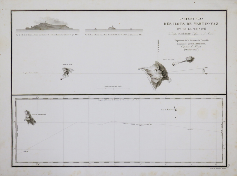
DUPERREY (Louis-Isidore).
[BRÉSIL/TRINDADE et MARTIN VAZ] Carte et plan des ilôts de Martin-Vaz et de la Trinité.
[1827]. 361 x 498 mm.
书商的参考编号 : LBW-4431
|
|
|
DUPERREY (Louis-Isidore).
[BRÉSIL/ÎLE de SANTA CATARINA] Carte d'une partie de la côte du Brésil comprise entre le Rio Guaratuba et la Laguna de Gurupaba - Plan de l'île Santa Catharina.
[1827]. 520 x 369 mm.
书商的参考编号 : LBW-4432

|
|
|
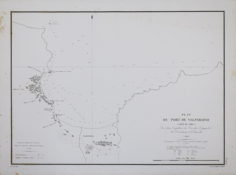
DUPERREY (Louis-Isidore).
[CHILI] Plan du port de Valparaiso (côte du Chili).
[1827]. 360 x 497 mm.
书商的参考编号 : LBW-4430
|
|
|
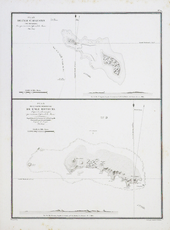
DUPERREY (Louis-Isidore).
[FIDJI/TUVALU] Plan de l'île St. Augustin (de Maurelle) - Plan de la partie méridionale de l'île Rotouma.
[1827]. 495 x 361 mm.
书商的参考编号 : LBW-4441
|
|
|
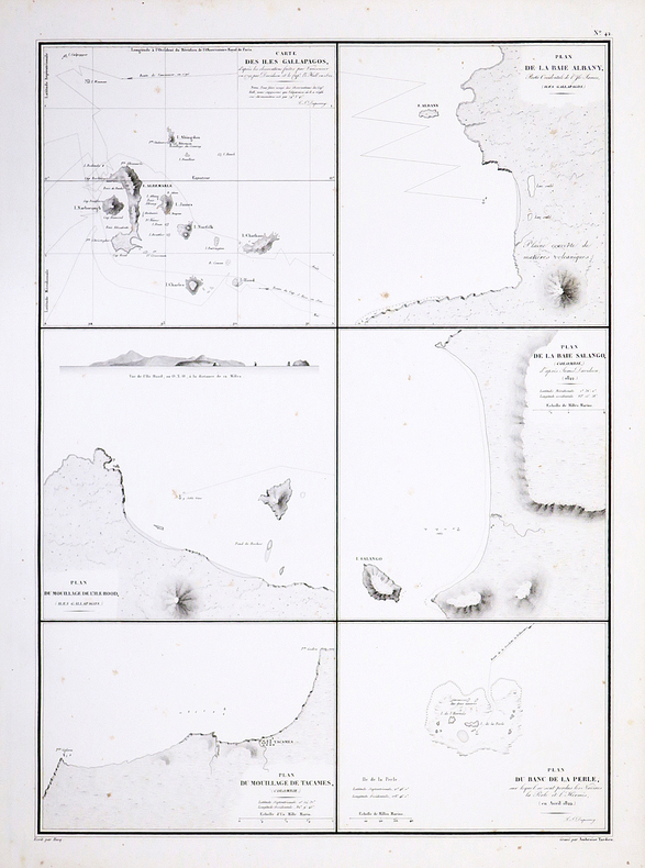
DUPERREY (Louis-Isidore).
[GALAPAGOS] Carte des îles Gallapagos.
[1827]. 500 x 361 mm.
书商的参考编号 : LBW-4426
|
|
|
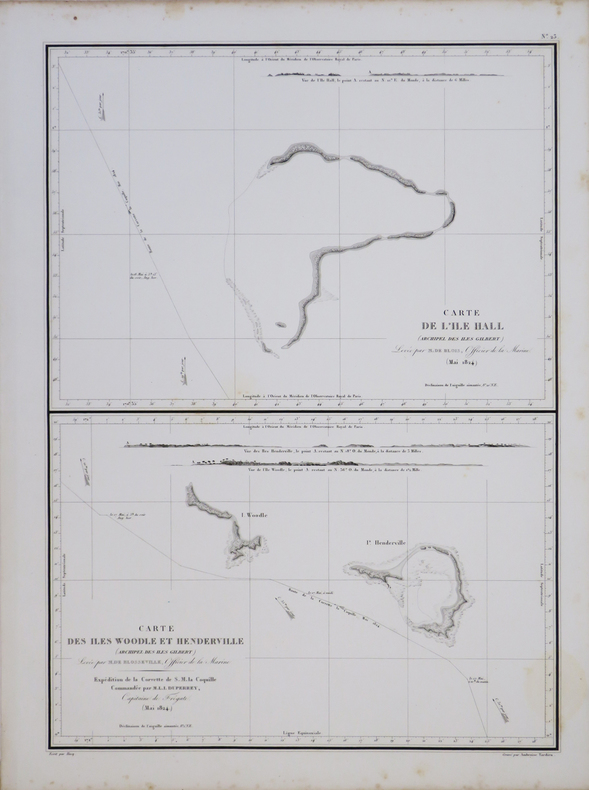
DUPERREY (Louis-Isidore).
[KIRIBATI/MICRONÉSIE] Carte de l'île Hall (archipel des îles Gilbert) - Carte des îles Woodle et Henderville (archipel des îles Gilbert).
[1827]. 504 x 361 mm.
书商的参考编号 : LBW-4443
|
|
|
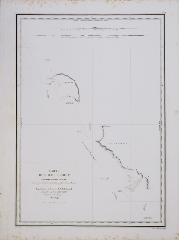
DUPERREY (Louis-Isidore).
[KIRIBATI/MICRONÉSIE] Carte des îles Bishop (archipel des îles Gilbert).
[1827]. 498 x 351 mm.
书商的参考编号 : LBW-4442
|
|
|
DUPERREY (Louis-Isidore).
[MICRONÉSIE] Plan de l'île Oualan.
[1827]. 760 x 503 mm.
书商的参考编号 : LBW-4444

|
|
|
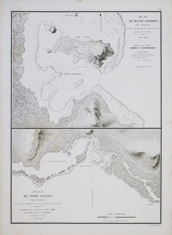
DUPERREY (Louis-Isidore).
[MICRONÉSIE] Plan du havre Chabrol (île Oualan) - Plan du port Lottin (île Oualan).
[1827]. 502 x 362 mm.
书商的参考编号 : LBW-4446
|
|
|
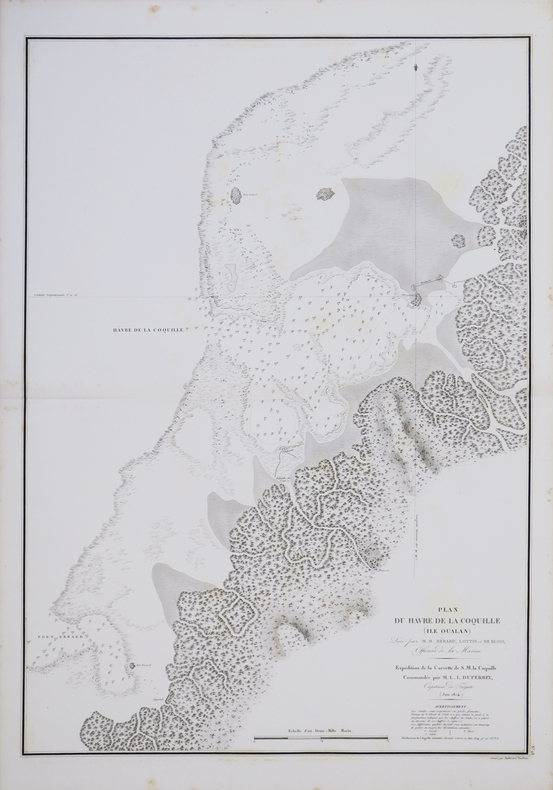
DUPERREY (Louis-Isidore).
[MICRONÉSIE] Plan du havre de la Coquille (île Oualan).
[1827]. 729 x 513 mm.
书商的参考编号 : LBW-4445
|
|
|
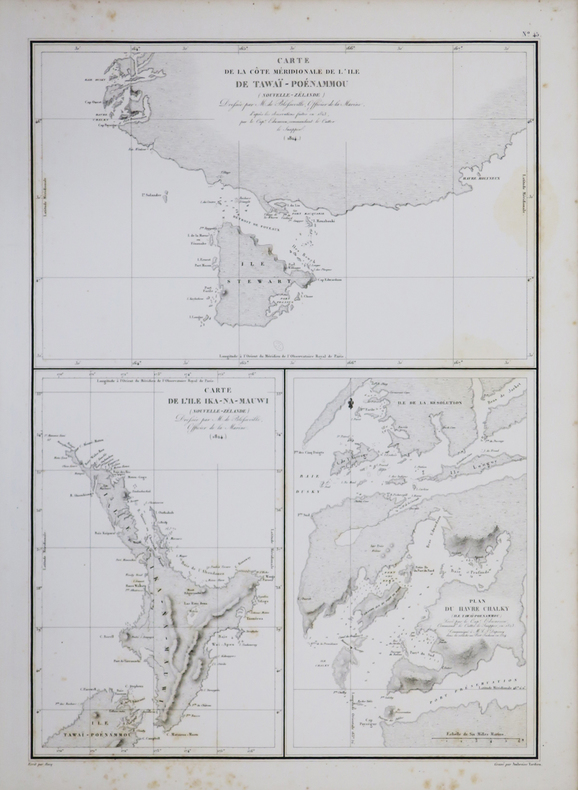
DUPERREY (Louis-Isidore).
[NOUVELLE-ZÉLANDE] Carte de la côte méridionale de l'île de Tawaï-Poénammou (Nouvelle Zélande) - Carte de l'île Ika-Na-Mauwi (Nouvelle Zélande) - plan du havre Chalky (île Tawaï-Poénammou).
[1827]. 503 x 359 mm.
书商的参考编号 : LBW-4434
|
|
|
DUPERREY (Louis-Isidore).
[NOUVELLE-ZÉLANDE] Plan de la rivière Shooukianga (île Ika-Na-Mauwi, Nouvelle-Zélande).
[1827]. 496 x 358 mm.
书商的参考编号 : LBW-4435

|
|
|
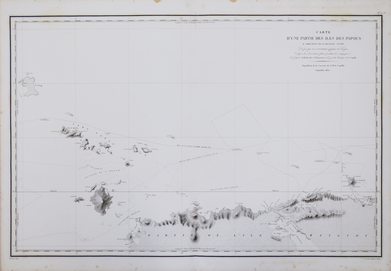
DUPERREY (Louis-Isidore).
[PAPOUASIE OCCIDENTALE] Carte d'une partie des îles des Papous au nord-ouest de la Nouvelle-Guinée.
[1827]. 496 x 772 mm.
书商的参考编号 : LBW-4440
|
|
|
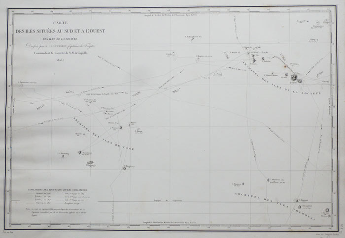
DUPERREY (Louis-Isidore).
[POLYNESIE FRANCAISE] Carte des îles situées au sud et à l'ouest des îles de la Société.
[1826]. 351 x 520 mm.
书商的参考编号 : LBW-1141
|
|
|
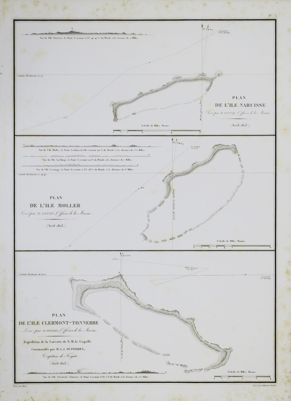
DUPERREY (Louis-Isidore).
[POLYNÉSIE FRANÇAISE/ARCHIPEL des TUAMOTU-GAMBIER] Plan de l'île Narcisse - Plan de l'île Moller - Plan de l'île Clermont-Tonnerre.
[1827]. 502 x 364 mm.
书商的参考编号 : LBW-4417
|
|
|
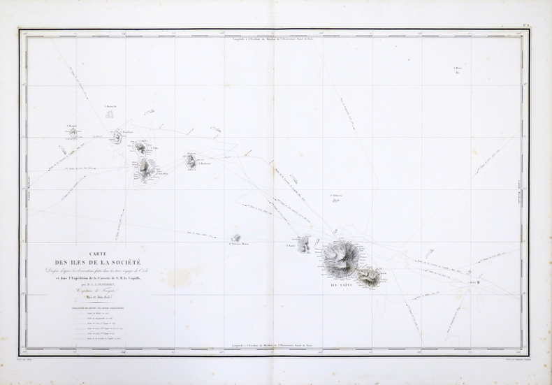
DUPERREY (Louis-Isidore).
[POLYNÉSIE FRANÇAISE/ÎLES de la SOCIÉTÉ] Carte des Îles de la Société.
[1827]. 470 x 739 mm.
书商的参考编号 : LBW-4422
|
|
|
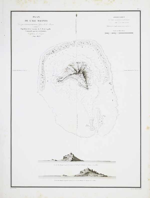
DUPERREY (Louis-Isidore).
[POLYNÉSIE FRANÇAISE/MAUPITI] Plan de l'île Maupiti.
[1827]. 489 x 360 mm.
书商的参考编号 : LBW-4419
|
|
|
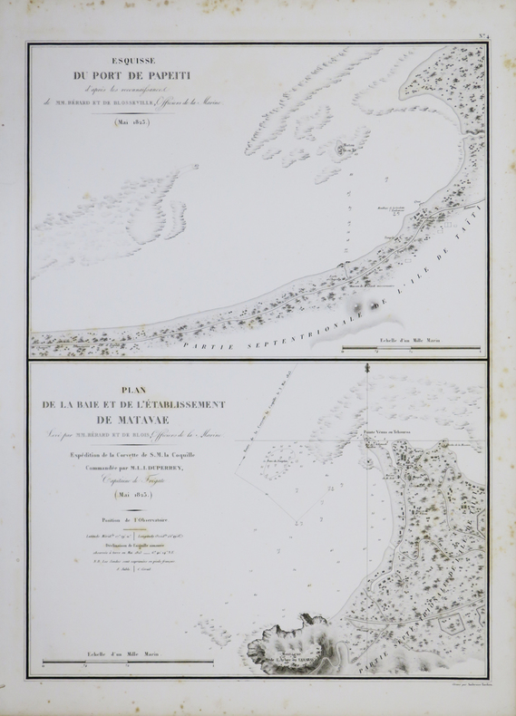
DUPERREY (Louis-Isidore).
[POLYNÉSIE FRANÇAISE/TAHITI] Esquisse du port de Papeiti - Plan de la baie et de l'établissement de Matavae.
[1827]. 498 x 363 mm.
书商的参考编号 : LBW-4421
|
|
|
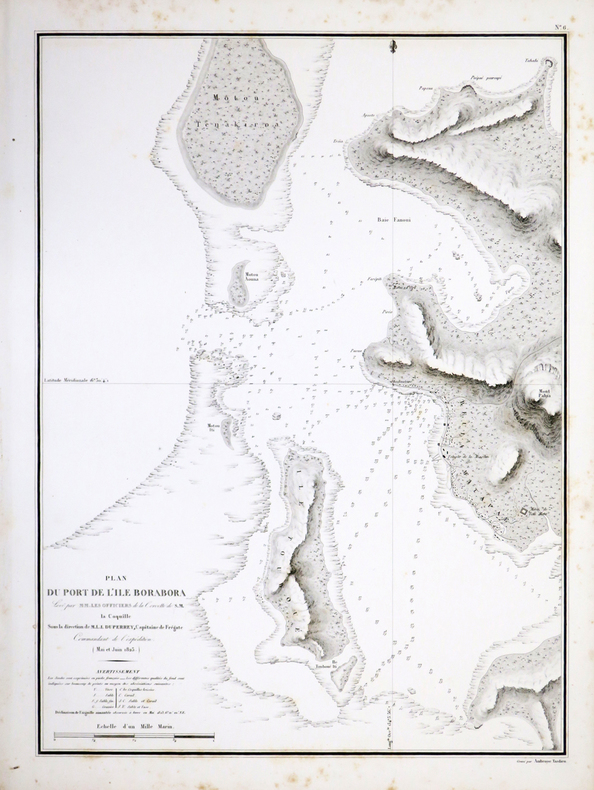
DUPERREY (Louis-Isidore).
[POLYNÉSIE FRANÇAISE/BORA BORA] Plan du port de l'île Borabora.
[1827]. 505 x 366 mm.
书商的参考编号 : LBW-4418
|
|
|
DUPERREY (Louis-Isidore);
[POLYNÉSIE FRANÇAISE/ARCHIPEL des TUAMOTU] Carte des îles Pomotou situées à l'est des îles de la Société.
[1827] 471 x 755 mm.
书商的参考编号 : LBW-6869
|
|
|
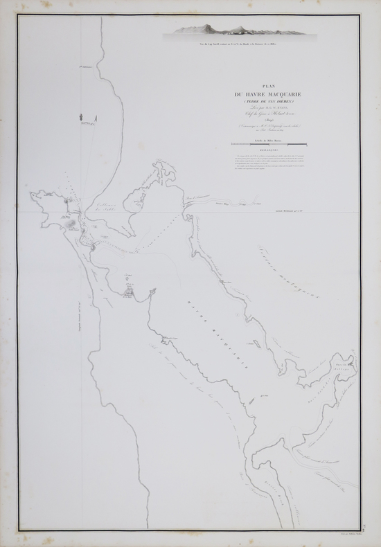
DUPERREY (Louis-Isidore).
[TASMANIE] Plan du havre Macquarie (Terre de Van Diémen).
[1827]. 756 x 501 mm.
书商的参考编号 : LBW-4433
|
|
 ?????????
 ?????PDF???
 RSS feed


