|
DUFOUR, Guillaume Henri (1787 - 1875):
Der Sonderbunds- Krieg und die Ereignisse von 1856. (Mit einer Editionsvorbemerkung) und eingeleitet durch eine biographische Skizze (von Edouard Sayous). 3. Aufl.
Basel, Schwabe, 1882, in-8vo, Front.-Portr. (Gen. Dufour; leicht stockfleckig) + 3 Bl. + 180 S. + 5 Kartenskizzen auf 4 Faltblättern, Vorsatz mit Besitzvermerk, Hldr. mit goldgepr. Rückentitel und etwas vergoldung, Rücken leicht verblasst, sonst sehr gutes Exemplar.
Bookseller reference : 44590aaf
|
|
|
Dufour, Guillaume Henri.:
Topographische Karte der Schweiz: Blatt XI, Pontarlier. Yverdon. Vermessen und herausgegeben auf Befehl der Eidgenössischen Behörden. Topographischer Atlas im Maasstab 1 : 100`000.
18 Segmenten auf Leinen aufgezogen. Aufgefaltet 55 x 75 cm. Landkarten de
|
|
|
Dufour, Guillaume Henri:
Topographische Karte der Schweiz: Blatt VII, Porrentruy - Solothurn (mit Nachträgen bis 1868). Vermessen und herausgegeben auf Befehl der Eidgenössischen Behörden. Topographischer Atlas im Maasstab 1 : 100.000.
18 Segmenten auf Leinen aufgezogen. Aufgefaltet 55 x 75 cm. - Stempel und Bezeichnung auf Leinenrücken. Landkarten de
|
|
|
DUFOUR, Landeskarte:
Landes Karte Schweiz 1:25.000: Auf Lwd. aufgezogen in Orig.-Schuber :
Bressanini & Mühlhaupt sculps., (1849) in-8vo, montée sur toile / auf Lwd aufgezogen, unvollständig, je 5 Karten in fünf Schuber mit Titelschild auf rotes Leder mit Aufschrift ‘Landes Karte 1: 25 000 Dem SAC zur Jahrhunderfeier - Eidg. Militärdepartement’. PAR CARTE 50.- Ens. 250.-
Bookseller reference : 13286aaf
|
|
|
DUFRESNOY, Lenglet:
Catalogue des meilleures cartes géographiques générales et partculières avec quelques remarques sur la choix qu'on en doit faire (Paris 1742).
Amsterdam, Meridian Publishing Co., MCMLXV, (), pt. in-8°, 252 p., brochure originale.
Bookseller reference : 40607aaf
|
|
|
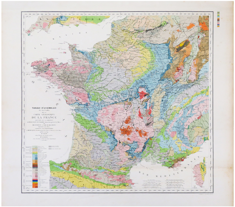
DUFRÉNOY (Armand) & BEAUMONT (Léonce Élie de) & ANDRIVEAU-GOUJON (Eugène).
[GÉOLOGIE] Tableau d'assemblage des six feuilles de la Carte géologique de la France exécutée sous la direction de M.r Brochant de Villiers, Inspecteur Général des Mines, par MM. Dufrénoy et Élie de Beaumont, ingénieurs des Mines, commencée sous l'administration de M.r Becquey, Directeur général des Ponts et Chaussées des Mines, publiée en 1841.
Paris, E. Andriveau-Goujon, 1864. 537 x 564 mm.
Bookseller reference : LBW-6836
|
|
|
Duguid A. Fortescue/Neal JIP. maps J. I.
Official History of the Canadian Forces in the Great War 1914-19: General Series Volume 1: Aug. 1914-Sept. 1915
Ottawa: J.O. Patenude 1938. 1st printing. VG/Good dust jacket. xxviii 596 p. folding color maps/charts folding map on front pastedown addenda/corrigenda slip laid in indexes 8vo; J.O. Patenude hardcover
Bookseller reference : 46436

|
|
|
DUGUID Col. A. Fortescue; NEAL Captain J. I. P. maps
Official History of The Canadian Forces in The Great War 1914-1919 General Series Vol. 1: From the Outbreak of War to the Formation of the Canadian Corps August 1914 - September 1915
Ottawa: Published by authority of the Minister of National Defence 1938. Hardcover. Very good/Fair. xxv 596 p. 25 cm. 9 fold-out colour maps and charts. Red cloth hardcover with gold lettering. In mylar-covered dustjacket with large chip and tear in rear and spine head. Canadian Army Medical Corps stamps on front endpapers. <br/><br/> Published by authority of the Minister of National Defence hardcover
Bookseller reference : 116352

|
|
|
DUMAS-VORZET Edmond
Paris 1867
- Librairie du Petit Journal, Paris 1867, 107,5x71cm, une feuille repliée. - First edition. Map of Paris divided in 20 arrondissements, wich were created in 1859. A very good copy with the 20 districts totally heightened in colors by a contemporary hand. The map is skillfully reinforced at the back. [FRENCH VERSION FOLLOWS] Edition originale. Plan de Paris divisé en 20 arrondissements, lesquels furent créés en 1859. Bel exemplaire avec les vingt quartiers entièrement aquarellés à l'époque. Carte habilement consolidée aux pliures du verso.

|
|
|
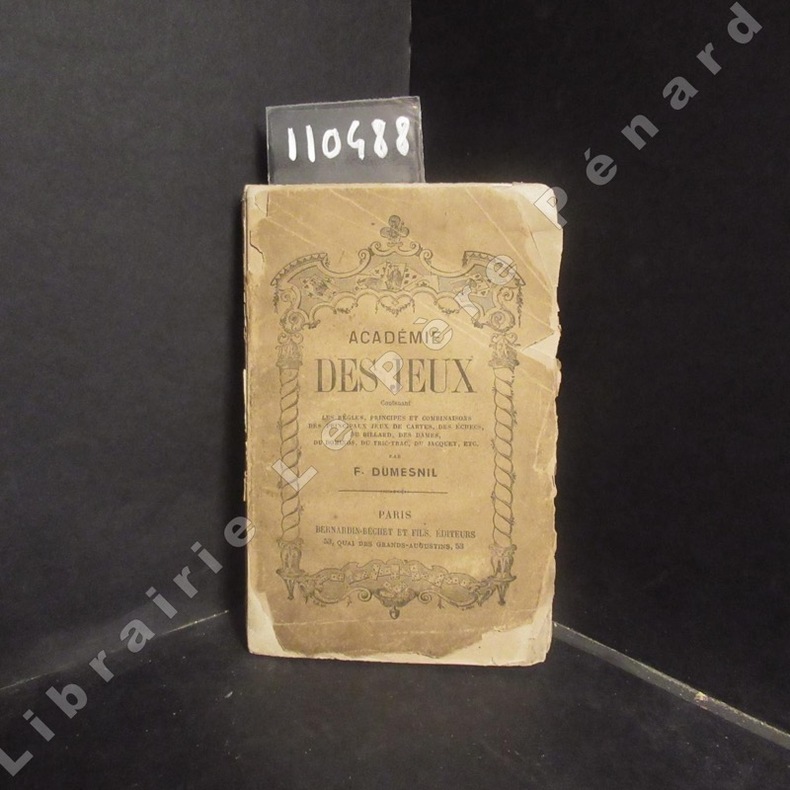
DUMESNIL, F.
Académie des jeux. Contenant le règles, principes et combinaisons des principaux jeux de cartes, des échecs, du billard, des dames, du dominos, du tric-trac, du jacquet, etc.
A PAris, Chez Bernardin-Béchet et Fils, Editeurs - Sans date - In-12, broché - 170 p.
Bookseller reference : 110488
|
|
|
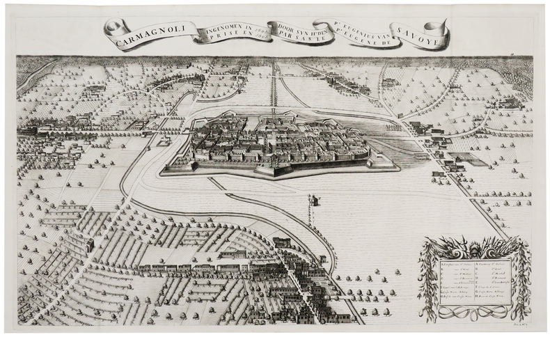
DUMONT (Jean).
[CARMAGNOLA] Carmagnoli ingenomen in 1691 door Syn H.t den P.r Eugenius van Savoye - Carmagnoli prise en 1691 par S.A.S. le P.r Eugène de Savoye.
[La Haye, Isaac van der Kloot, 1729]. 494 x 819 mm.
Bookseller reference : LBW-6099
|
|
|
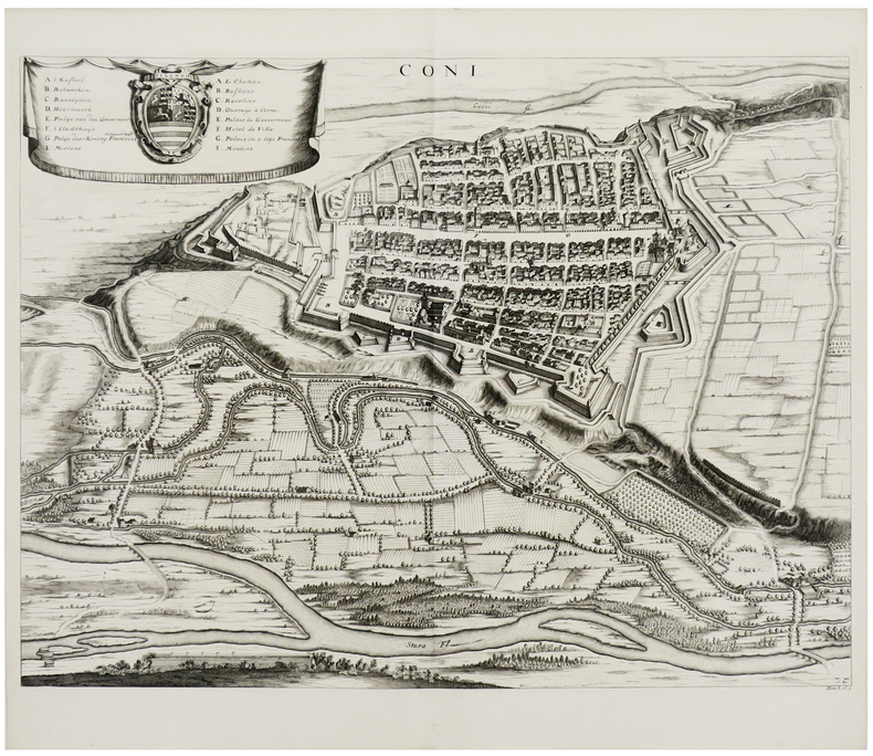
DUMONT (Jean).
[CUNEO] Coni.
[La Haye, Isaac van der Kloot, 1729]. 445 x 577 mm.
Bookseller reference : LBW-6129
|
|
|
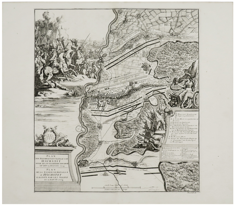
DUMONT (Jean).
[HÖCHSTÄDT] Plan der roemrugtige veltslag van Hochstet door de geallieerde gewonne op den 13 augusti 1704 - Plan de la glorieuse bataille d'Hochstet gagnée par les alliez le 13 aoust 1704.
[La Haye, Isaac van der Kloot, 1729]. 476 x 428 mm.
Bookseller reference : LBW-6130
|
|
|
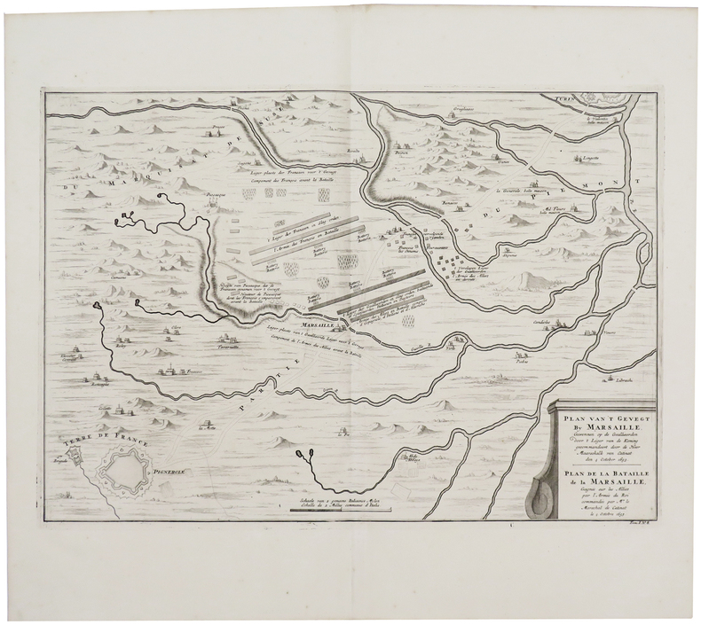
DUMONT (Jean).
[MARSAGLIA/PINEROLO] Plan van't gevegt by Marsaille [...] van Catinat den 4 october 1693 - Plan de la bataille de La Marsaille [...] par Mr le méaréchal de Catinat le 4 octobre 1693.
[La Haye, Isaac van der Kloot, 1729]. 368 x 533 mm.
Bookseller reference : LBW-6131
|
|
|
DUMONT (Jean).
[OUDENAARDE] Plan der veldslag van Oudenaerde den 11 July 1708 - Plan de la bataille d'Oudenaerde du 11 juillet 1708.
[La Haye, Isaac van der Kloot, 1729]. 484 x 585 mm.
Bookseller reference : LBW-6128

|
|
|
DUMONT (Jean).
[SAINT-OMER] St. Omer en Artois avec les forts des environs.
La Haye, Pierre Husson, 1720. 359 x 471 mm.
Bookseller reference : LBW0621d

|
|
|
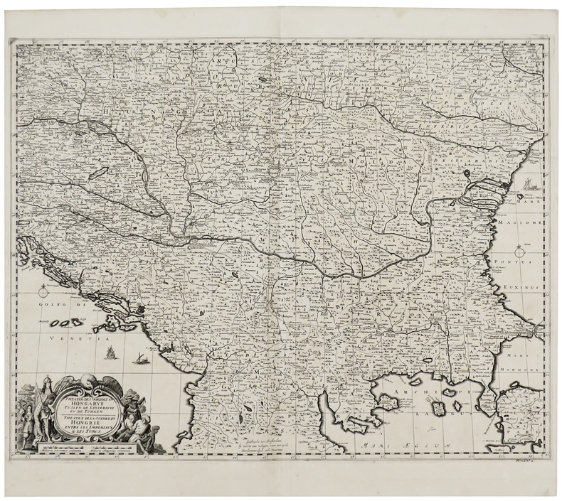
DUMONT (Jean).
Theater des oorlogs in Hongarye tussen de Keyserlyke en de Turken - Théâtre de la guerre en Hongrie entre les Impériaux & les Turcs.
[La Haye, Isaac van der Kloot, 1729] 452 x 583 mm.
Bookseller reference : LBW-6098
|
|
|
DUMONT (Jean);
[SAINT-VENANT] St. Venant assiégé & pris en 1710 par le Pr. d'Orange.
La Haye Pierre Husson 1720 401 x 461 mm.
Bookseller reference : LBW06219

|
|
|
DUMONT D'URVILLE (Jules-Sébastien-César) & GOUPIL (Ernest).
[JAVA] Entrée du canal de Samarang (Ile de Java).
[Paris, 1841-1854]. 260 x 391 mm.
Bookseller reference : LBW-1312

|
|
|
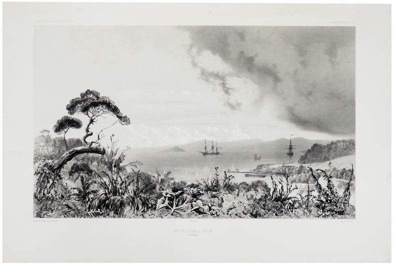
DUMONT D'URVILLE (Jules-Sébastien-César) & LE BRETON (Louis).
[NOUVELLE-ZELANDE] Baie de Sarah's Bosom (Iles Auckland).
Paris, [1841-1854]. 282 x 426 mm.
Bookseller reference : LBW-1309
|
|
|
DUMONT D'URVILLE (Jules-Sébastien-César) & LE BRETON (Louis).
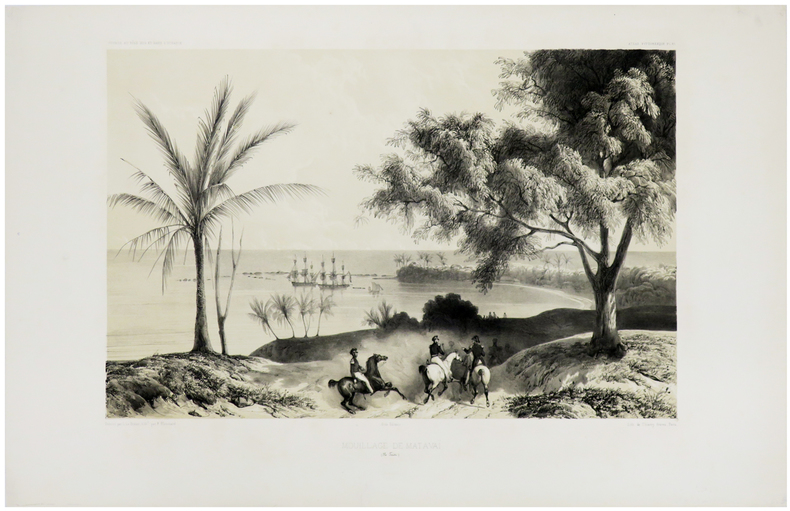
[TAHITI] Mouillage de Matavaï (Ile Taïti).
Paris, [1841-1854]. 290 x 400 mm.
Bookseller reference : LBW-1308
|
|
|
DUMONT D'URVILLE (Jules-Sébastien-César) & LE BRETON (Louis).
[ÎLES MARQUISES] L'Astrolabe et la Zélée. Arrivée à Noukahiva.
Paris et New-York, V.e Turgis, [1853]. 286 x 398 mm.
Bookseller reference : LBW-8317

|
|
|
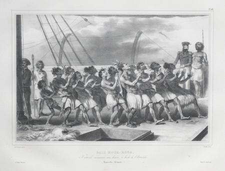
DUMONT D'URVILLE (Jules-Sébastien-César) & RAFFET (Auguste).
[NOUVELLE-ZELANDE] Baie Houa-Houa. Naturels exécutant une danse à bord de l'Astrolabe (Nouvelle-Zélande).
[Paris, 1833]. 263 x 348 mm.
Bookseller reference : LBW061b5
|
|
|
DUMONT D'URVILLE (Jules-Sébastien-César) & SAINSON (Louis-Auguste de).
[AUSTRALIE/NOUVELLE-ZELANDE] Nouvelle-Hollande - Nouvelle-Zélande.
[Paris, 1833]. 370 x 233 mm.
Bookseller reference : LBW061b0
|
|
|
DUMONT D'URVILLE (Jules-Sébastien-César) & SAINSON (Louis-Auguste de).
[NOUVELLE-GUINEE] La corvette l'Astrolabe, attaquée par les naturels de la côte nord (Nouvelle Guinée).
[Paris, 1833]. 243 x 342 mm.
Bookseller reference : LBW061b7
|
|
|
DUMONT D'URVILLE (Jules-Sébastien-César) & SAINSON (Louis-Auguste de).
[NOUVELLE-ZELANDE] L'Anse de l'Astrolabe (Nouvelle-Zélande).
[Paris, 1833]. 257 x 362 mm.
Bookseller reference : LBW061b1
|
|
|
DUMONT D'URVILLE (Jules-Sébastien-César) & SAINSON (Louis-Auguste de).
[NOUVELLE-ZELANDE] Nouvelle-Zélande.
Paris, [1833]. 332 x 275 mm.
Bookseller reference : LBW061ab
|
|
|
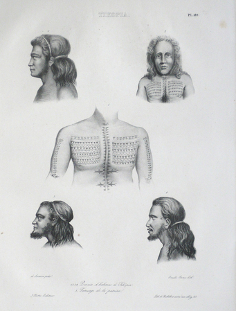
DUMONT D'URVILLE (Jules-Sébastien-César) & SAINSON (Louis-Auguste de).
[TIKOPIA] Tikopia.
[Paris, 1833]. 383 x 230 mm.
Bookseller reference : LBW061a5
|
|
|
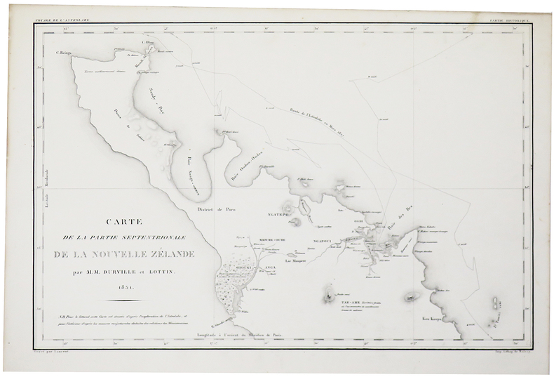
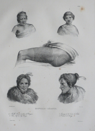
DUMONT D'URVILLE (Jules-Sébastien-César).
[NOUVELLE-ZÉLANDE] Carte de la partie septentrionale de la Nouvelle Zélande par M.M. Durville et Lottin.
[Paris, 1833]. 302 x 460 mm.
Bookseller reference : LBW-5460
|
|
|
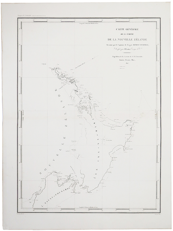
DUMONT D'URVILLE (Jules-Sébastien-César).
[NOUVELLE-ZÉLANDE] Carte générale de la partie de la Nouvelle Zélande reconnue par le Capitaine de Frégate Dumont d'Urville, dressée par M.r Lottin, enseigne de V.au.
[Paris, 1833]. 581 x 429 mm.
Bookseller reference : LBW-5457
|
|
|
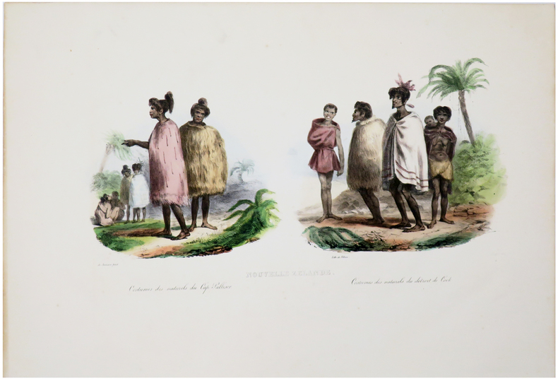
DUMONT D'URVILLE (Jules-Sébastien-César).
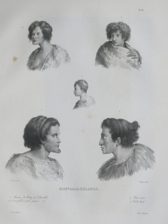
[NOUVELLE-ZÉLANDE] Nouvelle Zélande. Costumes des naturels du Cap Palliser - Costumes des naturels du Détroit de Cook.
[Paris, 1833]. 202 x 380 mm.
Bookseller reference : LBW-5465
|
|
|
DUMONT D'URVILLE (Jules-Sébastien-César).
[NOUVELLE-ZÉLANDE] Nouvelle-Zélande. Costume des guerriers de Shouraki - Costume des habitans de Houa-Houa.
[Paris, 1833]. 250 x 330 mm.
Bookseller reference : LBW-5462

|
|
|
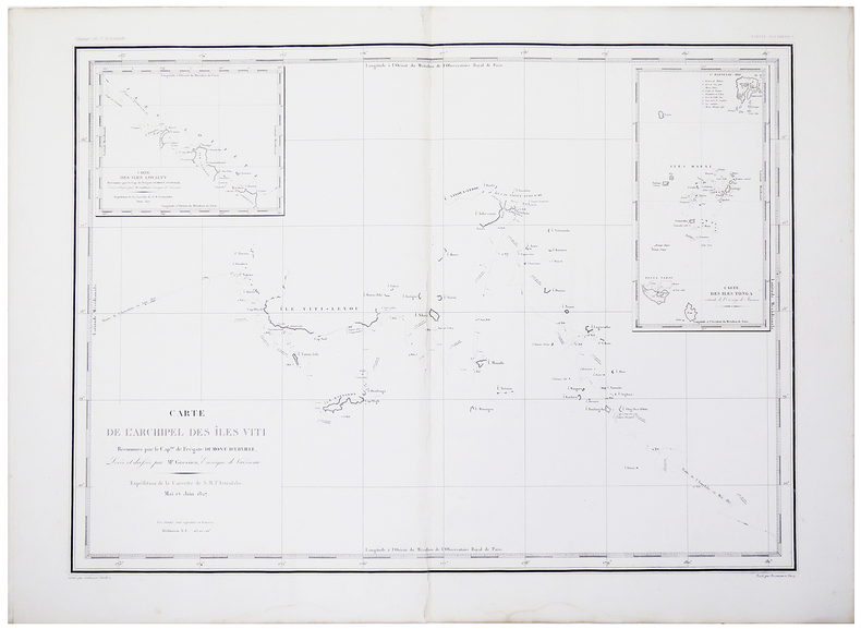
DUMONT D'URVILLE (Jules-Sébastien-César).
[ÎLES FIDJI] Carte de l'archipel des Îles Viti reconnues par le Cap.ne de frégate Dumont d'Urville.
[Paris, 1833]. 430 x 585 mm.
Bookseller reference : LBW-5461
|
|
|
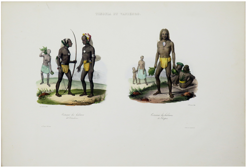
DUMONT D'URVILLE (Jules-Sébastien-César).
[ÎLES SALOMON] Tikopia et Vanikoro. Costumes des habitans de Vanikoro - Costumes des habitans de Tikopia.
[Paris, 1833]. 220 x 335 mm.
Bookseller reference : LBW-5464
|
|
|
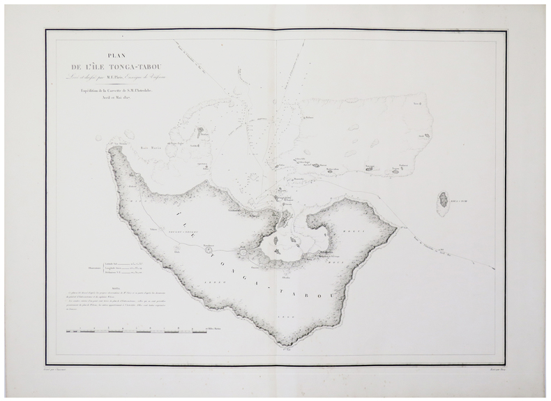
DUMONT D'URVILLE (Jules-Sébastien-César).
[ÎLES TONGA] Plan de l'île Tonga-Tabou levé et dressé par M.E. Pâris, enseigne de vaisseau.
[Paris, 1833]. 427 x 580 mm.
Bookseller reference : LBW-5456
|
|
|
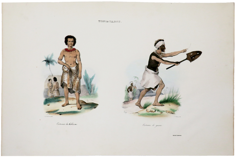
DUMONT D'URVILLE (Jules-Sébastien-César).
[ÎLES TONGA] Tonga-Tabou. Costumes des habitans - Costume de guerre.
[Paris, 1833]. 250 x 350 mm.
Bookseller reference : LBW-5463
|
|
|
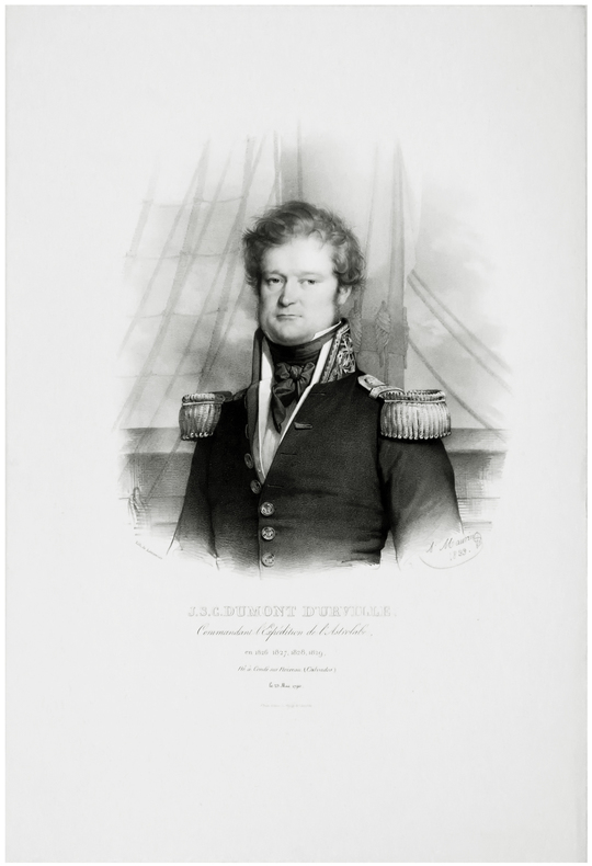
DUMONT D'URVILLE (Jules-Sébastien-César).
J.S.C. Dumont d'Urville, commandant l'expédition de l'Astrolabe, en 1826, 1827, 1828, 1829, né à Condé sur Noireau (Calvados) le 23 mai 1790.
[Paris, 1833]. 343 x 240 mm.
Bookseller reference : LBW-5448
|
|
|
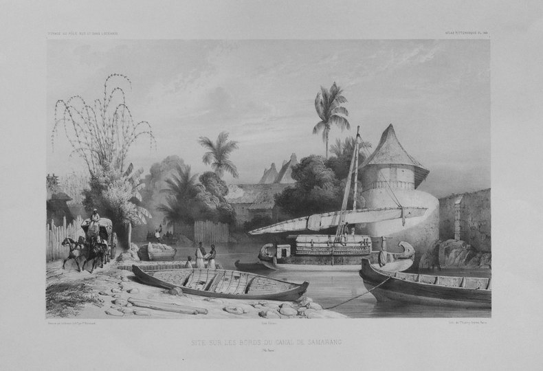
DUMONT D'URVILLE (Jules-Sébastien-César);LE BRETON (Louis);
[JAVA] Site sur les bords du canal de Samarang (Ile Java).
Paris 1841-1854 262 x 358 mm.
Bookseller reference : LBW-1311
|
|
|
DUMONT D'URVILLE (Jules-Sébastien-César);SAINSON (Louis-Auguste de);
[NOUVELLE-ZELANDE] Nouvelle-Zélande.
Paris, [1833]. 352 x 262 mm.
Bookseller reference : LBW061aa
|
|
|
DUMONT D'URVILLE:
Voyage pittoresque autour du monde. Résumé général des voyages de découvertes de Magellan, Tasman, Dampier, Byron, Wallis, Carteret, Bougainville, Cook, Lapérouse, G. Bligh, Vancouver, d'Entrecasteaux, [...].
Paris, L. Tenré et Henri Dupuy, 1834. 2 volumes in-4 de [4]-VIII-576 et [4]-584 pages, demi-basane verte, dos lisses ornés de filets dorés, traces d'étiquette dans la partie supérieure des dos, petite fente à un mors, coiffes, coupes et coins frottés, premier cahier du tome second légèrement déboîté, avec une petite mouillure.
Bookseller reference : 8783
|
|
|
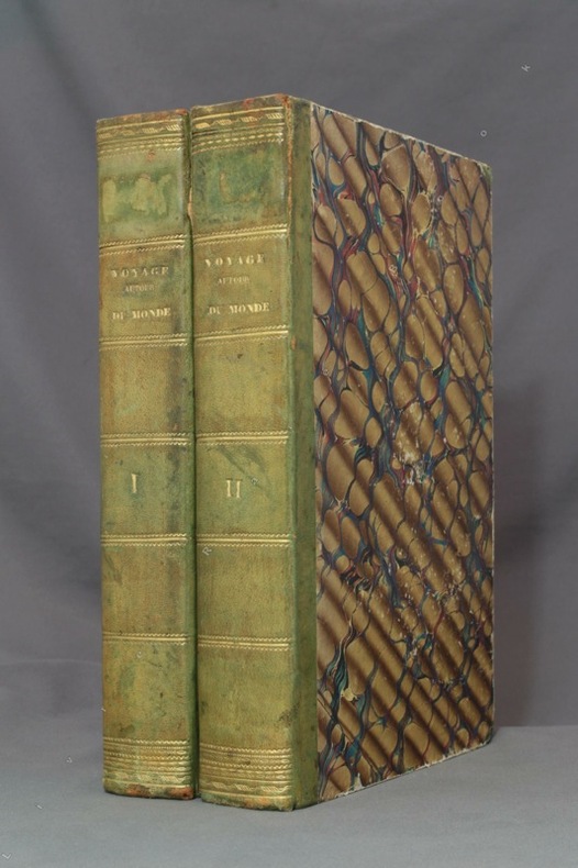
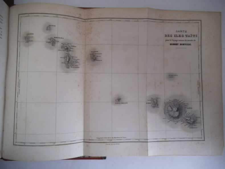
DUMONT D’ URVILLE
Voyage autour du monde.
Publié sous la direction du Contre Amiral DUMONT D’ URVILLE. Nouvelle édition revue, corrigée. Deux tomes en deux volumes in 4 demi-cuir rouge. Titre et caissons dorés. Larges filets à froid sur les plats. Tome1 : faux-titre, frontispice gravé, sous serpente, titre XI, 550 pages, 1 page de table des chapitres, tranches mouchetées. 21 gravures sur acier, hors-texte, sous serpente, y compris le frontispice, Une grande carte dépliante Tour du Monde. Furne & Cie 1848. Rousseurs, importantes, fortes à certaines pages ainsi qu’au verso de certaines gravures. Une mouillure à l’ange supérieur droit. Tome 2 : faux-titre, frontispice gravé sous serpente« mort du Capitaine COOK », 542 pages, 20 gravures sur acier, hors-texte , sous serpente, y compris le frontispice. Grande carte dépliante des Iles TAHITI pour les voyages autour du monde ; 1 page de table des chapitres. Rousseurs, fortes et concentrées à certaines pages, ainsi qu’au verso de certaines gravures. Furne et Cie 1848
Bookseller reference : 9721
|
|
|
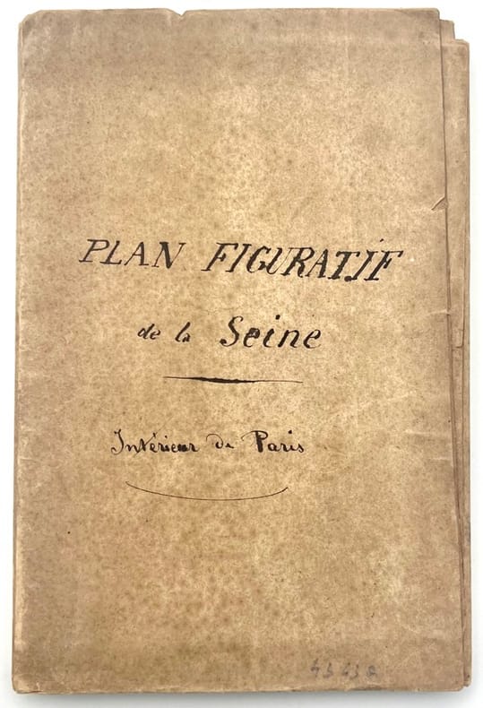
DUNAIME.
Plan figuratif de la Seine, intérieur de Paris.
, , 1833. Lithographie gravée sur papier fort d’environ 85 115 cm, colorié.
Bookseller reference : 43437
|
|
|
Dundrum Maps & HarperCollins
All Ireland Road Atlas
HarperCollins 2012. Paperback. Acceptable. Disclaimer:A readable copy. All pages are intact and the cover is intact. Pages can include considerable notes-in pen or highlighter-but the notes cannot obscure the text. At ThriftBooks our motto is: Read More Spend Less.Dust jacket quality is not guaranteed. HarperCollins paperback
Bookseller reference : G0007818130I5N00 ISBN : 0007818130 9780007818136

|
|
|
Dundrum Maps
All Ireland Roads and Motorways
Perma-Bound Books. Map. Used; Acceptable. Dust jacket is damaged Simply Brit Shipped with Premium postal service within 24 hours from the UK with impressive delivery time. We have dispatched from our book depository; items of good condition to over ten million satisfied customers worldwide. We are committed to providing you with reliable and efficient service at all times. 01/01/2009 Perma-Bound Books unknown
Bookseller reference : 2949914 ISBN : 0800000099 9780800000097
|
|
|
Dundrum Maps
ALL IRELAND ROAD MAP
01/01/2006. Paperback. Used; Good. WE SHIP WITHIN 24 HRS FROM LONDON UK 98% OF OUR ORDERS ARE RECEIVED WITHIN 7-10 DAYS. We believe you will be completely satisfied with our quick and reliable service. All orders are dispatched as swiftly as possible! Buy with confidence! paperback
Bookseller reference : 3631544 ISBN : 0007733305 9780007733309
|
|
|
Dundrum Maps
All Ireland Roads and Motorways
Perma-Bound Books 01/01/2009. Map. Used; Good. WE SHIP WITHIN 24 HRS FROM LONDON UK 98% OF OUR ORDERS ARE RECEIVED WITHIN 7-10 DAYS. We believe you will be completely satisfied with our quick and reliable service. All orders are dispatched as swiftly as possible! Buy with confidence! Perma-Bound Books unknown
Bookseller reference : 3330202 ISBN : 0800000099 9780800000097
|
|
|
Dundrum Maps
Greater Dublin Street Atlas
London: Collins 2005. 88pp 265 x 190 mm colour maps based on Ordinance Survey of Ireland scale 4.4 inches to 1 mile 1: 14400 index to all street names in Greater Dublin area. NEW. B61. Laminated Pictorial Cover. NEW/No Jacket. Collins Paperback
Bookseller reference : 15500 ISBN : 0007733321 9780007733323
|
|
|
DUNKERQUE. MANUSCRIT.
Carte de la côte de Dunkerque depuis Mardick jusques aux limites des Territoires Autrichiens.
1779. 330 x 532 mm, entoilée au XIXe et pliée.
Bookseller reference : LBW-4096

|
|
|
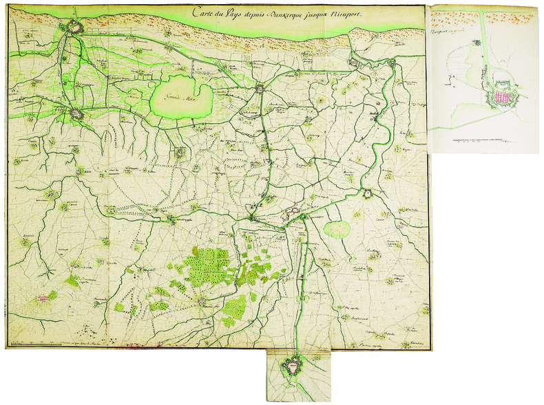
DUNKERQUE. MANUSCRIT.
Carte du pays depuis Dunkerque jusqua Nieuport.
[circa 1750]. 482 x 596 mm.
Bookseller reference : LBW-4125
|
|
|
Dunlop Touring Maps
The Dunlop Touring Maps of the British Isles with Contours Coloured
Great Britian: Edward J. Burrow & Co 1938. Paperback. Good -. Illustrated. Paperback. 32 sections of touring maps. Circa 1938. Illustrated in color. No writing in the book. Spine mostly gone. Full refund if not satisfied. Edward J. Burrow & Co paperback
Bookseller reference : 029915
|
|
 Receive by email
 Download as PDF document
 RSS feed


