|
DEROY (Isidore).
[LE HAVRE] Le Hâvre. Vue prise de la mer - El Avre de Gracia. Vista tomada del mar.
Paris et New-York, L. Turgis J.ne, [circa 1860]. 380 x 498 mm.
书商的参考编号 : LBW-7314

|
|
|
DEROY (Isidore).
[MARSEILLE] Vue générale de Marseille - Vista general de Marsella.
Paris et New-York, L. Turgis J.ne, [vers 1870]. 375 x 497 mm.
书商的参考编号 : LBW-7618

|
|
|
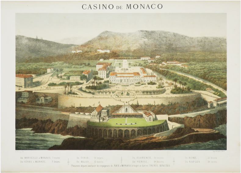
DEROY (Auguste-Victor).
[MONACO] Casino de Monaco [et] Grands Magasins de la Paix. Première Maison du monde. Paris.
Paris, Becquet, [circa 1872]. 322 x 418 mm et 316 x 383 mm.
书商的参考编号 : LBW-7570
|
|
|
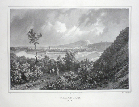
DEROY;
BESANCON (Doubs).
Paris Benard circa 1850 231 x 298 mm.
书商的参考编号 : LBW03d57
|
|
|
DEROY;
BOURGES (Cher).
Paris Benard circa 1850 218 x 289 mm.
书商的参考编号 : LBW03d64

|
|
|
DEROY;
DIJON (Côte-d'Or).
Paris Benard circa 1850 226 x 298 mm.
书商的参考编号 : LBW03d54

|
|
|
DEROY (Isidore);
Florence. Palais Pitti - Firenze. Palazzo Pitti.
Paris Jeannin circa 1850 161 x 242 mm.
书商的参考编号 : LBW02e71
|
|
|
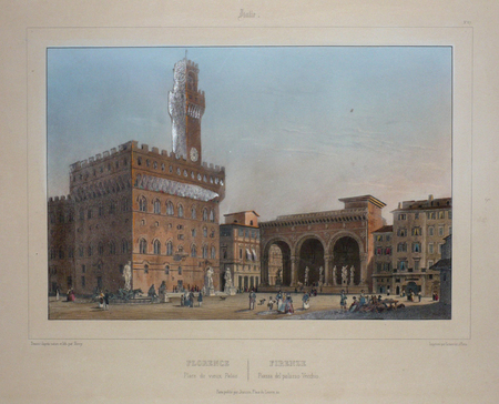
DEROY (Isidore);
Florence. Place du Vieux Palais - Firenze. Piazza del Palazzo Vecchio.
Paris Jeannin circa 1850 164 x 242 mm.
书商的参考编号 : LBW02e70
|
|
|
DERICHSWEILER, W. / HEIM, Alb.:
Führer durch das Medelser=Gebirge. Das Gebiet der Medelserhütte, der Sektion Uto des Schweizer Alpen Club.
Frauenfeld, Huber, 1910, in-8vo, V + 2 Bl. + 84 S. mit 1 Bildnis, 26 Bergzeichnungen, 5 geologischen Profilen und 3 Kartenskizzen. Original-Leinenband.
书商的参考编号 : 42174aaf
|
|
|
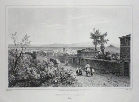
DEROY;
MONTBRISON (Loire).
Paris Benard circa 1850 221 x 295 mm.
书商的参考编号 : LBW03d4b
|
|
|
DEROY (Isidore);
Rome. Le Forum - Roma. Foro romano.
Paris Jeannin circa 1850 230 x 265 mm.
书商的参考编号 : LBW00274
|
|
|
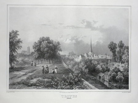
DEROY;
TROYES (Aube).
Paris Benard circa 1850 224 x 298 mm.
书商的参考编号 : LBW03d4c
|
|
|
DERNUET André.
TROYES EN CARTES POSTALES ANCIENNES.
Bibliothèque europeenne-Zaltbommel / Pays-bas,sans date ( vers1975), un volume in-8 oblong , 20,5 x15 cm, cartonnage editeur illustré, 156 reproductions de cartes postales anciennes. Exemeplaire légèrement jauni, bas du dos légèrement frotté, sinon bon état.
书商的参考编号 : 6803
|
|
|
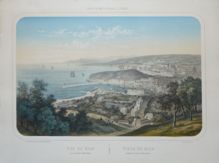
DEROY (Isidore);
Vue de Nice prise du chemin de Mont-Alban - Vista de Niza tomada del camino de Monte-Albano.
Paris L. Turgis circa 1850 380 x 501 mm.
书商的参考编号 : LBW-1139
|
|
|
DESCRIPTION de l'ÉGYPTE.
[ASSOUAN/ÎLE d'ÉLÉPHANTINE] Île d'Éléphantine et Syène. Plan général de l'Île d'Éléphantine, de Syène, et des carrières de granit exploitées par les anciens Égyptiens.
[Paris, Imprimerie Impériale, 1809]. 680 x 687 mm.
书商的参考编号 : LBW-8217

|
|
|
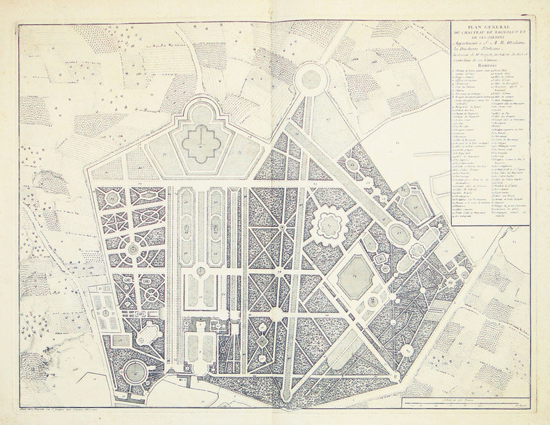
DESGOTS (Claude).
[BAGNOLET] Plan général du chasteau de Bagnolet et de ses jardins, appartenant à S.A.R. Madame la duchesse d'Orléans, du dessein de Mr. Desgotz, architecte du roi et controlleur de ses bâtimens.
Paris, Mariette, 1727. 418 x 551 mm.
书商的参考编号 : LBW-2763
|
|
|
DESESSART (?).
[CALVADOS] Plan général du château de Falaise, dans lequel on avait proposé en 1792 de placer non seulement la maison d'arrêt, mais encore l'administration du district, la police correctionnelle et la gendarmerie nationale.
Falaise, 6 floréal an 6 [25 avril 1798]. 34 x 53 cm.
书商的参考编号 : LBW-7425

|
|
|
DESBUISSONS (Édouard) & ANDRIVEAU-GOUJON (Eugène).
[CANAL de SUEZ] Carte de la Basse Égypte et du canal maritime de Suez, dressée par Desbuissons.
Paris, E. Andriveau-Goujon, 1882. En 18 sections montées sur toile et repliées, formant une carte de 540 x 698 mm ; étiquette au dos de l'éditeur E. Andriveau-Goujon."
书商的参考编号 : LBW-7852

|
|
|
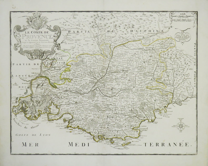
DESNOS (Louis-Charles).
[PROVENCE] Le Comté de Provence et le Comtat Venaissin.
Paris, C.L. Desnos, 1772. 436 x 561 mm.
书商的参考编号 : LBW-3524
|
|
|
DESBOIS (Martial).
[TROYES] Plan de la ville, fauxbourgs et dépendances de Troyes capitalle de Champagne.
1747. 542 x 624 mm.
书商的参考编号 : LBW-6401

|
|
|
DESNOS Louis Charles:
Almanach géographique, ou petit atlas élémentaire, composé de cartes générales et particulières des différents empires, royaumes et républiques de l'Europe et des autres parties de la Terre.
Paris, Desnos, 1770. Petit in-12 de [12]-XXVIII-[12]-143-[1], plein maroquin grenat, dos lisse orné de de fleurons et roulettes dorés, pièce de titre verte foncée, triple filet doré en encadrement des plats, filet doré sur les coupes et roulette dorée sur les chasses, tranches dorées.
书商的参考编号 : 16440
|
|
|
DESNOS (Louis-Charles).
Carte de France divisée en 86 départements formant la nouv. division de la Rép.e décrétée par l'Assemblée Nation.le & sanction. en 1792.
Paris, C.n Desnos, 1793. En 6 feuilles non jointes pouvant former une carte de 1,54 x 1,50 m.
书商的参考编号 : LBW-4303

|
|
|
DESNOS (Louis-Charles).
Carte de France divisée par province et divisions militaires, et tous ces départemens y compris les neuf départemens réunis de la Belgique. Avec des routes qui s'étendent à deux et trois cent lieues sur les États voisins de la France, savoir l'Angleterre, la Belgique, la Hollande, l'Allemagne, la Suisse, le Piémont, l'Italie, et l'Espagne.
Paris, [circa 1802]. En 28 sections montées sur toile et repliées, formant une carte de 1,08 x 1,32 m ; sous étui de papier avec pièce de titre bleue.
书商的参考编号 : LBW-8218

|
|
|
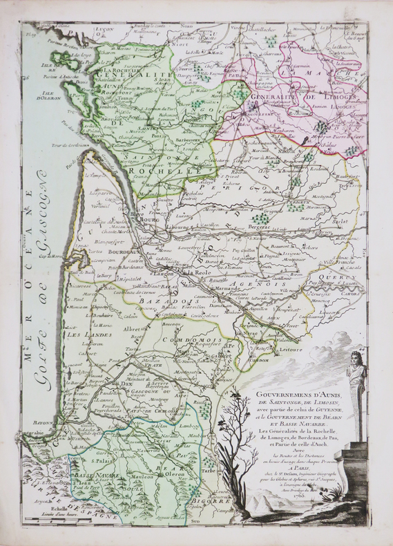
DESNOS (Louis-Charles).
Gouvernements d'Aunis, de Saintonge, de Limosin, avec partie de celui de Guyenne et le gouvernement de Béarn et Basse Navarre.
Paris, Sr. Desnos, 1765 [1766]. 357 x 247 mm.
书商的参考编号 : LBW-4498
|
|
|
DESNOS (Louis-Charles).
L'Asie dressée sur de nouveaux mémoires assujettis aux observations astronomiques.
Paris, Desnos, 1766. 482 x 710 mm.
书商的参考编号 : LBW-7417

|
|
|
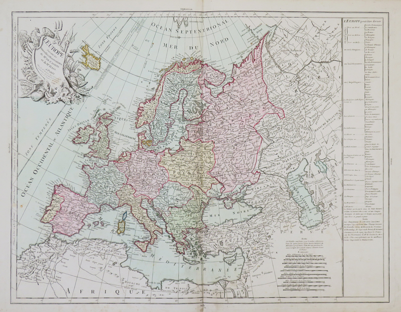
DESNOS (Louis-Charles).
L'Europe suivant les nouvelles observations de Mr. de Cassini et de Mr. Haas.
Paris, Sr. Desnos, 1790. 498 x 644 mm.
书商的参考编号 : LBW-4943
|
|
|
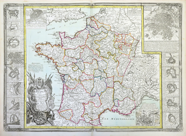
DESNOS (Louis-Charles).
La France divisée en ses principaux gouvernements avec toutes les routes de ce royaume.
Paris, Desnos, 1782. 510 x 731 mm.
书商的参考编号 : LBW-4311
|
|
|
DESSUART (Mage)
LA CARTOMANCIE : DEVIS ET DESTINS
Editions PML.,1995 - 1 Volume reliure cartonnée éditeur toilée noire avec jaquette illustrée en couleurs 25 x 29,5 - 142 pages avec illustrations en couleurs -Les cartes ont un langage, cela peut sembler étonnant aux sceptiques, mais ceux-ci n'ont qu'à lire ce livre pour s'apercevoir que la cartomancie est une affaire sérieuse bien loin du charlatanisme et de son folklore. Cet ouvrage traite de la façon la plus complète de la cartomancie, que ce soit au niveau de l'histoire, de ses statuts, de son évolution et bien sûr de sa pratique. Que disent les cartes et comment les lire ? Ce livre expose tout ce que cette pratique a de fascinant et de modernité. Il est un élément indispensable pour répondre à cette question universelle que nous nous posons perpétuellement à nous-même : qui suis-je ?
书商的参考编号 : 15754
|
|
|
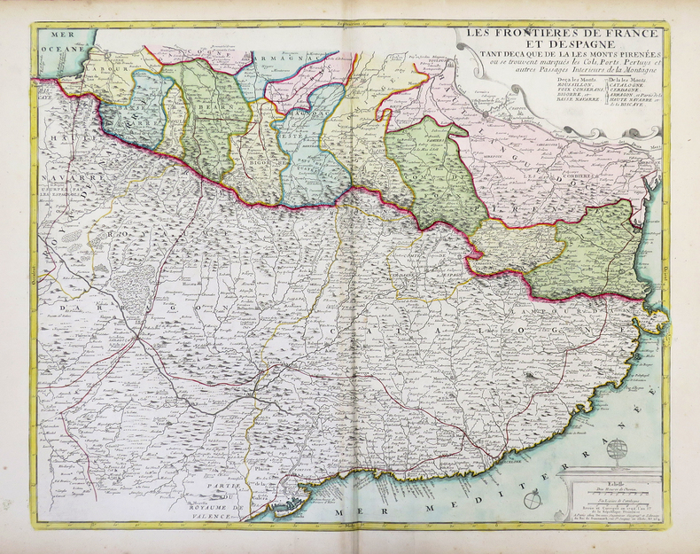
DESNOS (Louis-Charles) & FER (Nicolas de).
Les frontières de France et d'Espagne tant deça que de là les Monts Pirénées.
Paris, Desnos, 1792. 498 x 603 mm.
书商的参考编号 : LBW-4312
|
|
|
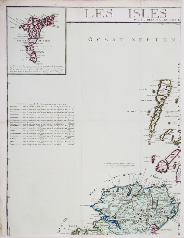
DESNOS (Louis-Charles).
Les Isles Britanniques où sont les royaumes d'Angleterre et d'Écosse, que nous appellons Grande-Bretagne et celuy d'Irlande.
Paris, S. Desnos, 1766. En quatre feuilles pouvant être jointes pour former une carte de 1,06 x 0,86 m.
书商的参考编号 : LBW-4461
|
|
|
DES CARTES RENE
LES PASSIONS DE L'AME.
CHEZ MICHEL BOBIN & NICOLAS LE GRAS. 1664. In-12. Relié plein cuir. Etat d'usage, Couv. convenable, Coiffe en tête abîmée, Intérieur frais. XLVIII + 272 pages - quelques lettrines et culs de lampe - dos à 5 nerfs - titre et fleurons dorés sur le dos - 2 photos disponibles.. . . . Classification Dewey : 840.04-XVII ème siècle
书商的参考编号 : R300114413
|
|
|
DESCARTES René ( DES CARTES )
LES PASSIONS DE L'AME
Rouen Chez Jacques Besongne 1651 petit in 8 (16x10,5) 1 volume reliure plein veau fauve, dos à nerfs orné de caissons dorés, tranches teintées rouge, page de titre; 22 feuillets liminaires non chiffrés (44 pages), 286 ppages. Edition rouennaise du dernier ouvrage philosophique de René Descartes. Bel exemplaire, exempt de rousseurs ( Photographies sur demande / We can send pictures of this book on simple request )
书商的参考编号 : 055665
|
|
|
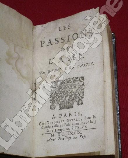
DES CARTES, René.
Les Passions de l'Ame.
A Paris, chez Theodore Girard, 1679, 1 volume in-16 de 150x85 mm environ, xlviij-282 pages, (2) ffb., plein veau brun (reliure restaurée), dos à nerfs portant titres dorés, orné de caissons à motifs dorés, coupes dorées, tranches mouchetées, ex-libris manuscrits sur la page de titre, p. a-ij et p. 103. Une mouillure en début et fin de volume, quelques erreurs de pagination (sans manque), sinon bon état..
书商的参考编号 : 97818
|
|
|
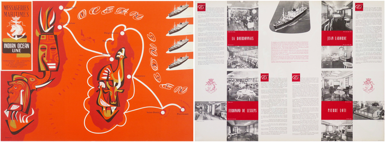
DESRUOL.
Messageries Maritimes. Indian Ocean Line. “Ferdinand de Lesseps” “Jean Laborde” “La Bourdonnais” “Pierre Loti”.
Paris, Messageries Maritimes, [1953]. 559 x 759 mm (marges comprises).
书商的参考编号 : LBW-8631
|
|
|
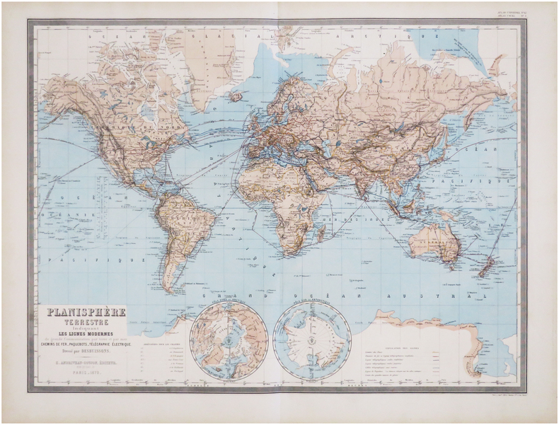
DESBUISSONS (Édouard);ANDRIVEAU-GOUJON (Eugène).
Planisphère terrestre indiquant les lignes modernes de grande communication par terre et par mer. Chemins de fer - Paquebots - Télégraphie électrique. Dressé par Desbuissons.
Paris, E. Andriveau-Goujon, 1872. 467 x 624 mm.
书商的参考编号 : LBW-7832
|
|
|
Desclozeaux, Jean-Pierre - Roy, Claude (préf.)
Souvenir d'exposition. Galerie Marquet, 30 novembre - 31 décembre 1976.
1976 Paris, Galerie Marquet, 1976. 10,5 x 16,5 cm, 12 cartes postales détachables sous serpente, dont 6 sont imprimées (titre, préface de Claude Roy, biographie, expositions, bibliographie) et 6 autres illustrées (5 dessins en couleurs et un portrait photographique en noir montrant uniquement la moustache et la barbe de l'illustrateur), l'ensemble sous un cartonnage saumon de l'éditeur à plats rapportés, demi-toile imprimée au dos et titre doré au premier plat.
书商的参考编号 : 2088

|
|
|
DESCHAPELLES Alexandre-Louis-Honoré
Traité du whiste
Paris Perrotin 1840 in-12 de 2 ff.n.ch. et 328 pp. demi-veau blond à coins, double filet doré le long des mors et des coins, dos à nerfs orné de filets dorés, pièce de titre noire [Rel. de l'époque], infimes épidermures, pet. rousseurs
书商的参考编号 : 15340
|
|
|
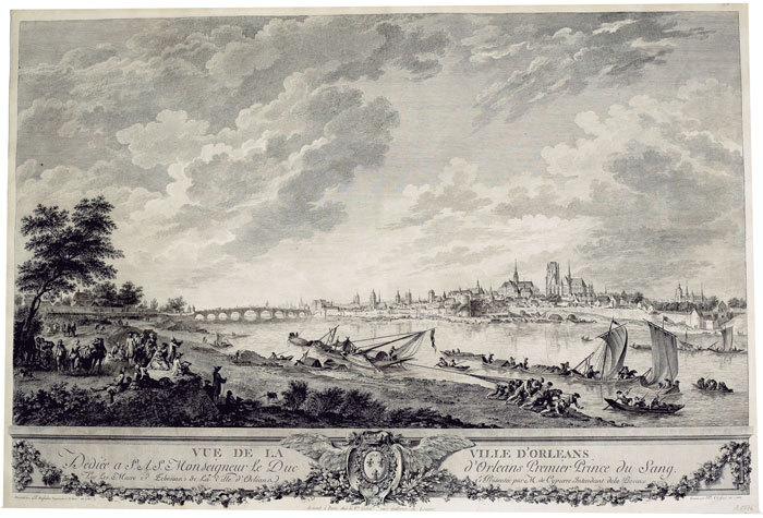
DESFRICHES (Aignan-Thomas);
Vue de la ville d'Orléans.
Paris Ve Cochin 1766 485 x 720 mm.
书商的参考编号 : LBW-476
|
|
|
DES CARTES Renati Rene Descartes
Opera Philosophica. Editio Ultima. Ab Auctore recognita
Amsterdam: Johannes Janssonius Jan Jansson the Younger 1656 1656. Third edition. 4to. 220x155mm. Three works in one volume. 1. Principia Philosophiae. pp. 36 241 1bl. 2. Specimina Philosophiae: seu Dissertatio de Methodo recte regendae rationis & veritatis in scientiis investigandae: Dioptrice et Meteora. Ex Gallico translata & ab Auctore perlecta variifque in luci emendata. pp. 16 290. 3. Passiones Animae per Renatum Des-Cartes: Gallice ab ipso conscriptae nunc autem in exterorum gratiam Latina civitate donatae ab H.D.M. i.u.l. pp. 20 115 5. Text in Latin. Woodcut illustrations throughout the text frontispiece portrait. Each work has its own title page and the whole has a separate plain title page. Full speckled calf decorated gilt border to upper and lower covers. Spine lavishly decorated in gilt five compartments each with a sunburst at the centre. Red morocco label lettered in gilt. Rubbing to corners and bottom edges and foot of spine. Rubbing to the joints cracking to the joint with the upper cover becoming detached but still holding. Contents are in excellent condition with two small holes resulting in very slight loss of text but no loss of meaning and four small tears to the corners not affecting text. A nice copy of this celebrated volume bringing together three of Descartes most important works including his last published work on the theory of the passions or emotions in a Latin translation for a wider audience. Indeed Descartes's work was much better known in Latin than in French until well into the nineteenth century. Amsterdam: Johannes Janssonius (Jan Jansson) the Younger 1656
书商的参考编号 : 3078

|
|
|
Destenay Anne L.; Illus. with maps Illustrator
China: Nagel's Encyclopedia-Guide
Nagel Publishers 1/1/1968. Hardcover. Very Good. 1504 32 pages 14 maps 16 cm. Hardcover and dust jacket. Good binding and cover. Wear chipping to dust jacket. This is an oversized or heavy book that requires additional postage for international delivery outside the US. Nagel Publishers hardcover
书商的参考编号 : 1505130108
|
|
|
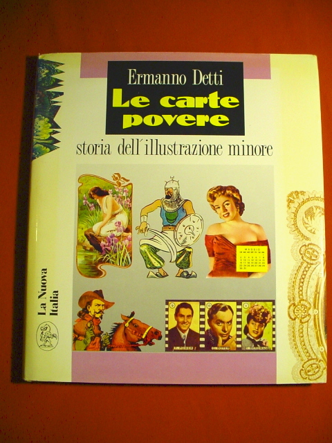
DETTI Ermanno
Le carte povere. Storia dell'illustrazione minore (La carte illustrée populaire. Histoire de l'illustration mineure).
La Nuova Italia, Firenze 1989. Album in-4 relié avec jaquette imprimée en couleurs, 159 pages, richement illustré de reproductions de cartes postales "fantaisie" anciennes, affiches, calendriers, boites, images pieuses etc., texte en italien, bon état. /// La Nuova Italia, Firenze,1989. Album in-4 rilegato con giacca da donna stampata in colori, 159 pagine, riccamente illustrate di riproduzioni di cartoline "fantasia" anziane, manifesti, calendari, zoppicano, immagini sacre ecc., buono stato.
书商的参考编号 : 18446
|
|
|
Deutsche Allgemeine Zeitung
Europa-Karte. Mit Länderbeschreibung und Flaggen 1:6.000.000.
Berlin, Deutscher Verlag 1940. 110 x 79 cm, (aus der propagandistischen Beschreibung des Deutschen Reiches": Völkischer Einheitsstaat, aufgebaut und geleitet nach dem Führergrundsatz. Nach 1000jähriger Zersplitterung von Adolf Hitler geeint.) Leichte altersbedingte Gebrauchsspuren, sonst gut.
书商的参考编号 : 1169
|
|
|
Deutscher Touring-Club
Iro Straßenkarte von Süddeutschland und angrenzenden Staaten.
München ca. 1910. Mehrfarb. Kte. in 24 Segment. auf Ln. 89x105 cm. Maßstab: 1:500.000. Landkarte.
书商的参考编号 : 8451
|
|
|
Devos Roger
Vie et traditions populaires savoyardes : chablais, faucigny, genevois, tarentaise, maurienne.
Ed. du parc Horvath, 1991, un volume in 8 broché, 191 pages, abondante iconographie en n&b et en couleurs. Bibliographie, index. Très bon état.
书商的参考编号 : 6448
|
|
|
DEVINAZ Danielle / JADOT Bernard
Villeurbanne autrefois.
Horvath 1988 Horvath, 1988, 160 p., broché. Dos un peu aplati vers le premier plat, page de titre annotée, quelques mots annotés sur une page de texte, bon état pour le reste.
书商的参考编号 : 117055
|
|
|
DeVoto Bernard; Maps by Erwin Raisz
The Course of Empire
Norwalk CT: The Easton Press 1988. Collector's Edition. Leather bound. Very good. 647pp. Octavo 23 cm Dark green leather with raised bands a gilt stamped title on the spine and gilt stamped designs on the spine and covers. All edges gilt. Patterned endpapers. Publisher's Notes from History tucked in. A previous owner's Easton Press bookplate is mounted to the front pastedown. Part of The Leather-Bound Library of American History. The Easton Press unknown
书商的参考编号 : 54300

|
|
|
DeVoto Bernard; Raisz Erwin maps by;
The Course of Empire
Boston: Houghton Mifflin and CompanyH 1952. Hardcover. Octavo; pp 647; VG-/G-; dark yellow spine with beige text; dust jacket has sunned spine; modest wear to exterior; some rubbing to edges; price clipped flap; mylar wrap; cloth has only light to exterior; clean strong boards; text block has slight foxing to exterior edges; pictorial endpapers; illustrated; deckled fore edge; tight binding;. 1329900. FP New Rockville Stock. Houghton, Mifflin and CompanyH hardcover books
书商的参考编号 : 1329900
|
|
|
DEWITTE, R.
CATALOGUE DES CARTES ET PLANS DE LA COLLECTION KAREL MESTDAGH.
, Bruges, Archives de l'Etat, 1935., Broche, couverture originale en vert, 16x24,5cm, 307pp.
书商的参考编号 : 6597
|
|
|
Dewdney, Selwyn
The Map That Grew
32 pages. A story which teaches young readers about mapmaking. Front free endpaper removed. Usual library markings. Worthy working copy. Book

|
|
|
DEYROLLE (Émile) & BERNARD (Albert).
Carte agricole n°9. Géographie économique et agricole. Animaux domestiques. Espèce bovine, ses produits.
Paris, Les Fils d'Émile Deyrolle, [1925]. 793 x 845 mm.
书商的参考编号 : LBW-7229

|
|
 ?????????
 ?????PDF???
 RSS feed


