|
Hedberg Maps Inc
Duluth Area Street Map: Includes Downtown Superior North Shore and Iron Range
2010-03-15. Good. Ships with Tracking Number! INTERNATIONAL WORLDWIDE Shipping available. May not contain Access Codes or Supplements. May be re-issue. May be ex-library. Shipping & Handling by region. Buy with confidence excellent customer service! unknown
Bookseller reference : 1593530471 ISBN : 1593530471 9781593530471

|
|
|
Hedberg Maps Inc
Duluth Area Street Map: Includes Downtown Superior North Shore and Iron Range
2010-03-15. New. Ships with Tracking Number! INTERNATIONAL WORLDWIDE Shipping available. May be re-issue. Buy with confidence excellent customer service! unknown
Bookseller reference : 1593530471n ISBN : 1593530471 9781593530471

|
|
|
Hedberg Maps Inc
Duluth MN: North Shore; Superior WI; Downtown Duluth; UMD
2008-03-07. New. Ships with Tracking Number! INTERNATIONAL WORLDWIDE Shipping available. May be re-issue. Buy with confidence excellent customer service! unknown
Bookseller reference : 1593530390n ISBN : 1593530390 9781593530396

|
|
|
Hedberg Maps; Hedberg Maps Editor; Hedberg Maps Illustrator;
Madison: UW & Capitol Area
Hedberg Maps 2011-05-30. Map. Used:Good. Hedberg Maps unknown
Bookseller reference : DADAX1593530595 ISBN : 1593530595 9781593530594
|
|
|
Hedberg Maps
Madison: UW & Capitol Area
2011-04-08. New. Ships with Tracking Number! INTERNATIONAL WORLDWIDE Shipping available. May be re-issue. Buy with confidence excellent customer service! unknown
Bookseller reference : 1593530595n ISBN : 1593530595 9781593530594

|
|
|
Hedberg Maps Inc Nat Case Editor
Mankato-New Ulm-St Peter-Waseca MN
Hedberg Maps Inc 2008-02-12. Map. Good. Hedberg Maps Inc unknown
Bookseller reference : SONG1593530277 ISBN : 1593530277 9781593530273
|
|
|
Hedberg Maps Inc; Nat Case Editor
Minneapolis and Saint Paul Downtown
Hedberg Maps Inc 2010-10-15. Map. Used:Good. Hedberg Maps Inc unknown
Bookseller reference : DADAX1593530501 ISBN : 1593530501 9781593530501
|
|
|
Hedberg Maps; Hedberg Maps Editor; Hedberg Maps Illustrator;
Minneapolis and St Paul Street Map
Hedberg Maps 2011-05-30. Map. Used:Good. Hedberg Maps unknown
Bookseller reference : DADAX1593530579 ISBN : 1593530579 9781593530570
|
|
|
Hedberg Maps Inc
Minneapolis and Saint Paul Downtown
2010-01-03. New. Ships with Tracking Number! INTERNATIONAL WORLDWIDE Shipping available. May be re-issue. Buy with confidence excellent customer service! unknown
Bookseller reference : 1593530501n ISBN : 1593530501 9781593530501

|
|
|
Hedberg Maps
Minneapolis and St Paul Street Map
2011-02-09. New. Ships with Tracking Number! INTERNATIONAL WORLDWIDE Shipping available. May be re-issue. Buy with confidence excellent customer service! unknown
Bookseller reference : 1593530579n ISBN : 1593530579 9781593530570

|
|
|
Hedberg Maps
Minneapolis & St Paul Street Map by Hedberg Maps
HEDBERG MAPS. New. Brand New. HEDBERG MAPS unknown
Bookseller reference : 58017 ISBN : 1593530579 9781593530570
|
|
|
Hedberg Maps
Minneapolis-St Paul North Metro Street Map
Hedberg Maps. New. Brand New. Hedberg Maps unknown
Bookseller reference : 892658 ISBN : 1593530544 9781593530549
|
|
|
Hedberg Maps
Minneapolis-St Paul West Metro Street Map
Hedberg Maps 2011-01-01. 2011. Map. Good. Hedberg Maps unknown
Bookseller reference : SONG1593530536 ISBN : 1593530536 9781593530532
|
|
|
Hedberg Maps Inc
Minneapolis at the Millennium: A Thousand Years of Change--Satellite Imagery Bird's-Eye Views Historical Topography 2000 . 1000
White Star Press. Used - Good. Shows some signs of wear and may have some markings on the inside. White Star Press unknown
Bookseller reference : GRP66433089 ISBN : 1885508603 9781885508607
|
|
|
Hedberg Maps Inc
Northeast Corridor: Rail Travelers Map
2017-06-01. Good. Ships with Tracking Number! INTERNATIONAL WORLDWIDE Shipping available. May not contain Access Codes or Supplements. May be re-issue. May be ex-library. Shipping & Handling by region. Buy with confidence excellent customer service! unknown
Bookseller reference : 1593530609 ISBN : 1593530609 9781593530600

|
|
|
Hedberg Maps Inc
Northeast Corridor: Rail Travelers Map
2017-06-01. New. Ships with Tracking Number! INTERNATIONAL WORLDWIDE Shipping available. May be re-issue. Buy with confidence excellent customer service! unknown
Bookseller reference : 1593530609n ISBN : 1593530609 9781593530600

|
|
|
Hedberg Maps Inc
Northeast Corridor: Rail Travelers Map
Hedberg Maps Inc. Used - Good. Good condition. Map Hedberg Maps Inc unknown
Bookseller reference : N26K-00083 ISBN : 1593530609 9781593530600
|
|
|
Hedberg Maps Inc Hedberg Maps Inc Editor Hedberg Maps Inc Illustrator
Northeast Corridor: Rail Travelers Map
Hedberg Maps Inc 2012-01-03. Second. Map. Good. Hedberg Maps Inc unknown
Bookseller reference : SONG1593530609 ISBN : 1593530609 9781593530600
|
|
|
Hedberg Maps
Northern Minnesota
Hedberg Maps 2005-06-01. Map. Good. Hedberg Maps unknown
Bookseller reference : SONG1885508336 ISBN : 1885508336 9781885508331
|
|
|
Hedberg Maps Inc
Princeton: Princeton University & Area Streets Professor Pathfinder's Campus Maps
Hedberg Maps Inc 2007-09-10. Map. Like New. Hedberg Maps Inc unknown
Bookseller reference : 1885508913-1-18359020 ISBN : 1885508913 9781885508911
|
|
|
Hedberg Maps
Red Wing MN Lake Pepin/Cannon Falls
Hedberg Maps 2001-01-01. 2001. Map. Good. Hedberg Maps unknown
Bookseller reference : SONG1885508816 ISBN : 1885508816 9781885508812
|
|
|
Hedberg Maps Inc
Southern Minnesota Regional & City Maps
2007-07-07. New. Ships with Tracking Number! INTERNATIONAL WORLDWIDE Shipping available. May be re-issue. Buy with confidence excellent customer service! unknown
Bookseller reference : 1885508409n ISBN : 1885508409 9781885508409

|
|
|
Hedberg Maps Inc; Nat Case Editor; Nat Case Illustrator; Nate Sievers Illustrator; Don Pirius Illustrator; Eric Hunden Illustrat
St. Cloud Street Map
Hedberg Maps 2005-08-01. Map. Used:Good. Hedberg Maps unknown
Bookseller reference : DADAX188550893X ISBN : 188550893X 9781885508935
|
|
|
Hedberg Maps Inc
St. Cloud Street Map
2005-03-01. Good. Ships with Tracking Number! INTERNATIONAL WORLDWIDE Shipping available. May not contain Access Codes or Supplements. May be re-issue. May be ex-library. Shipping & Handling by region. Buy with confidence excellent customer service! unknown
Bookseller reference : 188550893X ISBN : 188550893x 9781885508935

|
|
|
Hedberg Maps Inc
St. Cloud Street Map
2005-03-01. New. Ships with Tracking Number! INTERNATIONAL WORLDWIDE Shipping available. May be re-issue. Buy with confidence excellent customer service! unknown
Bookseller reference : 188550893Xn ISBN : 188550893x 9781885508935

|
|
|
Hedberg Maps
The Love Map
Hedberg Maps Inc 2003-01-01. Map. Good. Hedberg Maps, Inc unknown
Bookseller reference : SONG1885508948 ISBN : 1885508948 9781885508942

|
|
|
Hedberg Maps
The Love Map
Hedberg Maps Inc 2003-01-01. Map. New. Still in factory shrinkwrapAND AS ALWAYS SHIPPED IN 24 HOURS; and emailed to you a USPS tracking number on all orders; all books are sanitized and cleaned for your protection before mailing Hedberg Maps, Inc unknown
Bookseller reference : 110704045 ISBN : 1885508948 9781885508942
|
|
|
Hedberg Maps
The Santa Map
2001-02-02. New. Ships with Tracking Number! INTERNATIONAL WORLDWIDE Shipping available. May be re-issue. Buy with confidence excellent customer service! unknown
Bookseller reference : 1885508840n ISBN : 1885508840 9781885508843

|
|
|
Hedberg Maps
Titanic Reference Map
1998-03-03. Good. Ships with Tracking Number! INTERNATIONAL WORLDWIDE Shipping available. May not contain Access Codes or Supplements. May be re-issue. May be ex-library. Shipping & Handling by region. Buy with confidence excellent customer service! unknown
Bookseller reference : 1885508271 ISBN : 1885508271 9781885508270

|
|
|
Hedberg Maps
Twin Cities Greater Metro: Regional Map
2011-01-02. New. Ships with Tracking Number! INTERNATIONAL WORLDWIDE Shipping available. May be re-issue. Buy with confidence excellent customer service! unknown
Bookseller reference : 1593530560n ISBN : 1593530560 9781593530563

|
|
|
Hedberg Maps Inc.
Twin Cities Metro Area: Minneapolis-St Paul
2006-03-07. New. Ships with Tracking Number! INTERNATIONAL WORLDWIDE Shipping available. May be re-issue. Buy with confidence excellent customer service! unknown
Bookseller reference : 1885508867n ISBN : 1885508867 9781885508867

|
|
|
Hedberg Maps Inc.
Twin Cities Supermap
2006-08-06. New. Ships with Tracking Number! INTERNATIONAL WORLDWIDE Shipping available. May be re-issue. Buy with confidence excellent customer service! unknown
Bookseller reference : 1885508921n ISBN : 1885508921 9781885508928

|
|
|
Hedberg Maps Inc.; Nat Case Editor
Twin Cities Metro Area: Minneapolis-St Paul
Hedberg Maps Inc 2006-04-01. Map. Used:Good. Hedberg Maps Inc unknown
Bookseller reference : DADAX1885508867 ISBN : 1885508867 9781885508867
|
|
|
Hedberg Maps Inc. Nat Case Editor
Twin Cities Metro Area: Minneapolis-St Paul
Hedberg Maps Inc 2006-04-01. 3rd edition 3rd printing. Map. Good. Hedberg Maps Inc unknown
Bookseller reference : SONG1885508867 ISBN : 1885508867 9781885508867
|
|
|
Hedberg Maps Inc. Nat Case Editor
Twin Cities Supermap
Hedberg Maps Inc 2006-05-01. 3rd edition 1st printing. Map. Good. Hedberg Maps Inc unknown
Bookseller reference : SONG1885508921 ISBN : 1885508921 9781885508928
|
|
|
Hedberg Maps
U.S. College and University Reference Map 6th edition
2017-12-18. New. Ships with Tracking Number! INTERNATIONAL WORLDWIDE Shipping available. May be re-issue. Buy with confidence excellent customer service! unknown
Bookseller reference : 1593530749n ISBN : 1593530749 9781593530747

|
|
|
Hedberg Maps
U.S. College and University Reference Map 6th edition
2017-12-18. Good. Ships with Tracking Number! INTERNATIONAL WORLDWIDE Shipping available. May not contain Access Codes or Supplements. May be re-issue. May be ex-library. Shipping & Handling by region. Buy with confidence excellent customer service! unknown
Bookseller reference : 1593530749 ISBN : 1593530749 9781593530747

|
|
|
Hedberg Maps Inc
University of Chicago & Hyde Park IL
2007-01-01. New. Ships with Tracking Number! INTERNATIONAL WORLDWIDE Shipping available. May be re-issue. Buy with confidence excellent customer service! unknown
Bookseller reference : 159353020Xn ISBN : 159353020x 9781593530204

|
|
|
Hedberg Maps Inc
University of Chicago & Hyde Park IL
2007-01-01. Good. Ships with Tracking Number! INTERNATIONAL WORLDWIDE Shipping available. May not contain Access Codes or Supplements. May be re-issue. May be ex-library. Shipping & Handling by region. Buy with confidence excellent customer service! unknown
Bookseller reference : 159353020X ISBN : 159353020x 9781593530204

|
|
|
Hedberg Maps
University of Michigan & Ann Arbor Streets Professor Pathfinder's Campus Maps
2007-01-04. New. Ships with Tracking Number! INTERNATIONAL WORLDWIDE Shipping available. May be re-issue. Buy with confidence excellent customer service! unknown
Bookseller reference : 1593530285n ISBN : 1593530285 9781593530280

|
|
|
Hedberg Maps
University of Michigan & Ann Arbor Streets Professor Pathfinder's Campus Maps
Hedberg Maps 2007-01-05. 4th. Map. Good. Hedberg Maps unknown
Bookseller reference : SONG1593530285 ISBN : 1593530285 9781593530280

|
|
|
Hedberg Maps Inc Nat Case Editor
University of Chicago & Hyde Park IL
Hedberg Maps Inc 2007-01-01. Map. Good. Hedberg Maps Inc unknown
Bookseller reference : SONG159353020X ISBN : 159353020X 9781593530204
|
|
|
Hegi, Franz (1774-1850)
Vue de Lucerne prise à la colline du Gütsch - Aussicht der Stadt Luzern, gezeichnet auf dem Gütsch.
Luzern, Xav. Meyer, 1811. Aquatinta von Franz Hegi nach Aug. Schmid. Bildgrösse: 45 x 58 cm. + Wichtig: Für unsere Kunden in der EU erfolgt der Versand alle 14 Tage verzollt ab Deutschland / Postbank-Konto in Deutschland vorhanden +, bild
Bookseller reference : 570BG

|
|
|
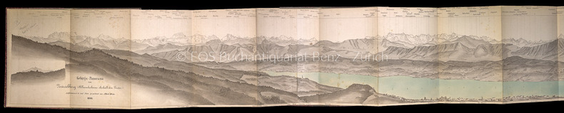
Heim, Albert:
Gebirgs-Panorama vom Zürichberg (Allmendscheune oberhalb dem Forster).
Zürich, Verlag der Schabelitz'schen Buchhandlung (Caesar Schmidt), 1866. Kolorierte Lithographie (in ursprüngl. 3 Teilen). Leporello in Halbleinen-Umschlag. Bildgrösse: 165 cm x 16,5 cm. Blattgrösse: 166 x 18,5 cm.
Bookseller reference : 229BG
|
|
|
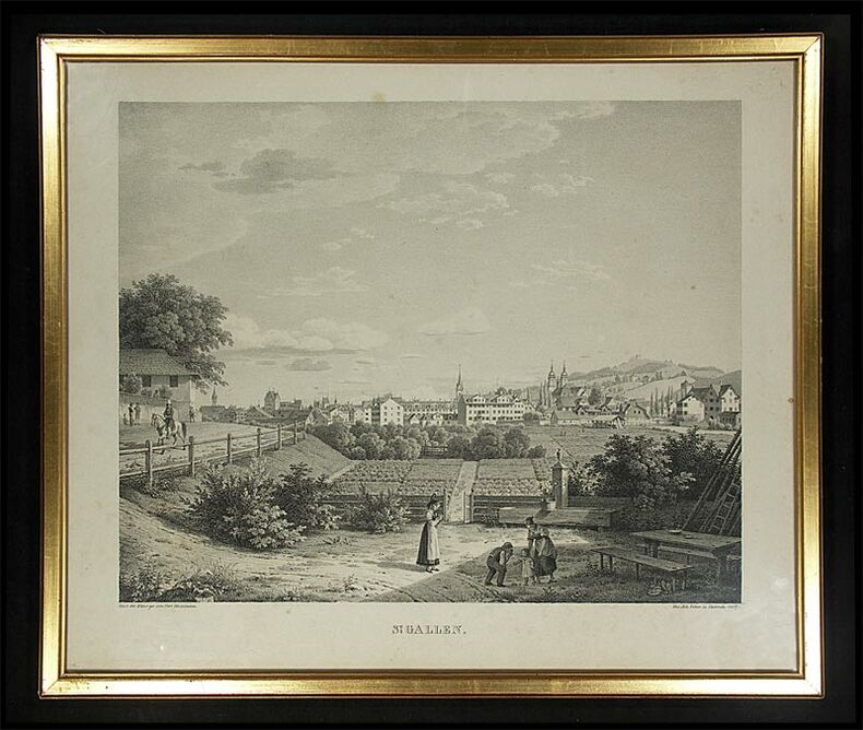
Heinzmann, Carl (1795-1846):
St. Gallen.
Carlsruhe, Joh. Velten, 1827. Lithographie. Bildformat: 42 x 50 cm.
Bookseller reference : 364DG
|
|
|
Heim, Albert
Gebirgs-Panorama vom Zürichberg (Allmendscheune oberhalb dem Forster).
Zürich, Verlag der Schabelitz'schen Buchhandlung (Caesar Schmidt), 1866. Kolorierte Lithographie (in ursprüngl. 3 Teilen). Leporello in Halbleinen-Umschlag. Bildgrösse: 165 cm x 16,5 cm. Blattgrösse: 166 x 18,5 cm. + Wichtig: Für unsere Kunden in der EU erfolgt der Versand alle 14 Tage verzollt ab Deutschland / Postbank-Konto in Deutschland vorhanden +, A|B [2 Warenabbildungen]
Bookseller reference : 229BG

|
|
|
Heinzmann, Carl (1795-1846)
St. Gallen.
Carlsruhe, Joh. Velten, 1827. Lithographie. Bildformat: 42 x 50 cm. + Wichtig: Für unsere Kunden in der EU erfolgt der Versand alle 14 Tage verzollt ab Deutschland / Postbank-Konto in Deutschland vorhanden +, 364D-Gr
Bookseller reference : 364DG

|
|
|
HELL (Anne Chrétien Louis de).
[CORSE/BOUCHES de BONIFACIO] Carte des bouches de Bonifacio.
[Paris], Dépôt-Général de la Marine, 1823. 625 x 941 mm.
Bookseller reference : LBW-8306

|
|
|
HELL (Anne Chrétien Louis de).
[CORSE] Carte générale de l'île de Corse.
[Paris], Dépôt-Général de la Marine, 1831. 922 x 620 mm.
Bookseller reference : LBW-8252

|
|
|
Helias, Pierre-Jakez
Images of Brittany
No marks or inscriptions. No creasing to covers or to slightly arched spine. A very clean very tight copy with bright unmarked boards, light indenting to front, traces of storage and no bumping to corners. 135pp. Superb images of Brittany in France with associated historic and leisure notes.

|
|
 Receive by email
 Download as PDF document
 RSS feed


