|
Küchlin, Jakob (1820–1885):
Thunersee Richtung Interlaken, Ringgenberg u. Brienzersee
(um 1850). Gouache. Bildgrösse: 34,5 x 48 cm. Blattgrösse: 42 x 55,5 cm.
Bookseller reference : 597BG

|
|
|
Kühnow, Friedrich - Blaeu, Joan
Ducatus Silesiae Laurani Delineatio. [Altkolorierter Original-Kupferstich / original colored copper engraving].
o.J. (Friedrich Kühnow, gestorben 1675. Kartograf. oan Blaeu (niederländisch ['jo??n 'bl?u]; deutsch Johannes Blaeu; * 1596 in Alkmaar, Niederlande; ? 28. Dezember 1673 in Amsterdam, Niederlande) war ein niederländischer Kartograf und Kupferstecher. 1654 schuf er den ersten Atlas Schottlands. Sein 1662 erstmals erschienener elfbändiger Atlas Maior gehörte zu den aufwendigsten und teuersten europäischen Atlanten des 17. Jahrhunderts.
Bookseller reference : 15894DB
|
|
|
L´Isle, Guillaume de
Karte von Rußland (map of Russia) mit Moskau im Zentrum.
Amsterdam, Pierre Schenk ohne Jahr [um 1720]. Kolorierte Kupferstich-Karte in der Plattengröße von 49 x 61 cm. An den Rändern stellenweise etwas bestoßen und mit kleinen Einrissen (z. T. hinterlegt).
Bookseller reference : 35072

|
|
|
L'ALPE n° 7
CARTOGRAPHIER LA MONTAGNE
2000 Glénat, Musée Dauphinois, Meylan, 2000. Un volume in 4° couverture semi-rigide à rabats, 113 pages, nombreuses illustrations, très bon état.
Bookseller reference : 2472
|
|
|
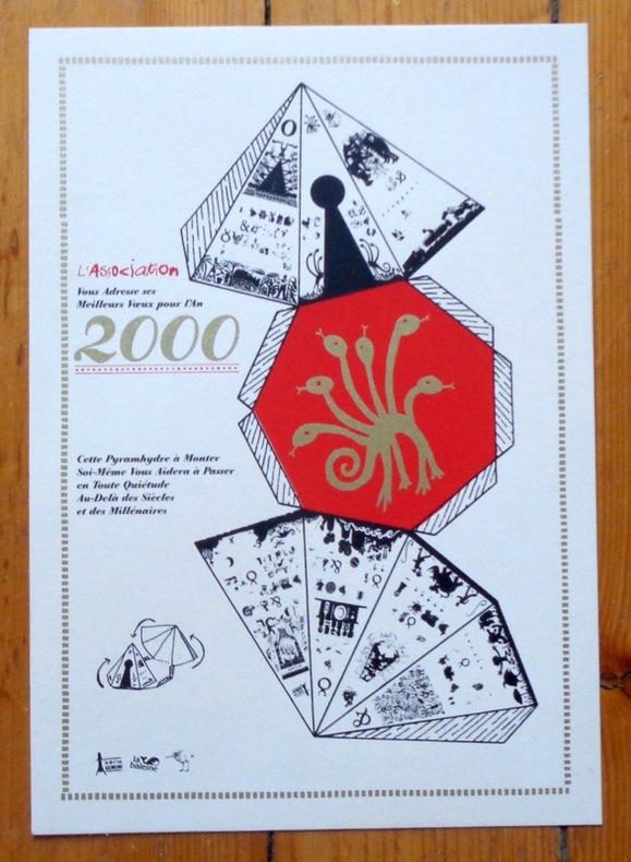
L'Association:
L'Association vous adresse ses meilleurs voeux pour l'an 2000.
L'Association. Carte de voeux au format A4.
Bookseller reference : 6180
|
|
|
L'Isle Guillaume de Pugsley William H. William Howard donor WH. Pugsley Collection of Early Canadian Maps W. H.
Carte du Canada ou de la Nouvelle France et des decouvertes qui y ont ete faites : dressee sur plusieurs observations et sur un grand nombre de relations imprimees ou manuscrites 1708 Leather Bound
2019. Leather Bound. New. Leather Binding on Spine and Corners with Golden Leaf Printing on round Spine extra customization on request like complete leather Golden Screen printing in Front Color Leather Colored book etc. Reprinted in 2019 with the help of original edition published long back 1708. This book is printed in black & white sewing binding for longer life Printed on high quality Paper re-sized as per Current standards professionally processed without changing its contents. As these are old books we processed each page manually and make them readable but in some cases some pages which are blur or missing or black spots. If it is multi volume set then it is only single volume if you wish to order a specific or all the volumes you may contact us. We expect that you will understand our compulsion in these books. We found this book important for the readers who want to know more about our old treasure so we brought it back to the shelves. Hope you will like it and give your comments and suggestions. Lang: - French. EXTRA 10 DAYS APART FROM THE NORMAL SHIPPING PERIOD WILL BE REQUIRED FOR LEATHER BOUND BOOKS. COMPLETE LEATHER WILL COST YOU EXTRA US$ 25 APART FROM THE LEATHER BOUND BOOKS. hardcover
Bookseller reference : LB1111007010836
|
|
|
L'Isle Guillaume de Pugsley William H. William Howard donor WH. Pugsley Collection of Early Canadian Maps W. H.
Carte du Canada ou de la Nouvelle France et des decouvertes qui y ont ete faites : dressee sur plusieurs observations et sur un grand nombre de relations imprimees ou manuscrites 1730 Leather Bound
2019. Leather Bound. New. Leather Binding on Spine and Corners with Golden Leaf Printing on round Spine extra customization on request like complete leather Golden Screen printing in Front Color Leather Colored book etc. Reprinted in 2019 with the help of original edition published long back 1730. This book is printed in black & white sewing binding for longer life Printed on high quality Paper re-sized as per Current standards professionally processed without changing its contents. As these are old books we processed each page manually and make them readable but in some cases some pages which are blur or missing or black spots. If it is multi volume set then it is only single volume if you wish to order a specific or all the volumes you may contact us. We expect that you will understand our compulsion in these books. We found this book important for the readers who want to know more about our old treasure so we brought it back to the shelves. Hope you will like it and give your comments and suggestions. Lang: - French. EXTRA 10 DAYS APART FROM THE NORMAL SHIPPING PERIOD WILL BE REQUIRED FOR LEATHER BOUND BOOKS. COMPLETE LEATHER WILL COST YOU EXTRA US$ 25 APART FROM THE LEATHER BOUND BOOKS. hardcover
Bookseller reference : LB1111007010859
|
|
|
L'Isle Guillaume de Pugsley William H. William Howard donor WH. Pugsley Collection of Early Canadian Maps W. H.
Carte du Canada ou de la Nouvelle France et des decouvertes qui y ont ete faites : dressee sur plusieurs observations et sur un grand nombre de relations imprimees ou manuscrites 1730 FULL LEATHER BOUND
2019. SUPER DELUXE EDITION. New. Antique look with Golden Leaf Printing and embossing with round Spine completely handmade bindingextra customization on request like Color Leather Colored book special gold leaf printing etc. Reprinted in 2019 with the help of original edition published long back 1730. This book is printed in black & white sewing binding for longer life Printed on high quality Paper re-sized as per Current standards professionally processed without changing its contents. As these are old books we processed each page manually and make them readable but in some cases some pages which are blur or missing or black spots. If it is multi volume set then it is only single volume if you wish to order a specific or all the volumes you may contact us. We expect that you will understand our compulsion in these books. We found this book important for the readers who want to know more about our old treasure in old look so we brought it back to the shelves. Hope you will like it and give your comments and suggestions. Lang: - French. EXTRA 10 DAYS APART FROM THE NORMAL SHIPPING PERIOD WILL BE REQUIRED. Normal Hardbound Edition is also available on request. unknown
Bookseller reference : SD1111007010859
|
|
|
L'Isle Guillaume de Pugsley William H. William Howard donor WH. Pugsley Collection of Early Canadian Maps W. H.
Carte du Canada ou de la Nouvelle France et des decouvertes qui y ont ete faites : dressee sur plusieurs observations et sur un grand nombre de relations imprimees ou manuscrites 1708 FULL LEATHER BOUND
2019. SUPER DELUXE EDITION. New. Antique look with Golden Leaf Printing and embossing with round Spine completely handmade bindingextra customization on request like Color Leather Colored book special gold leaf printing etc. Reprinted in 2019 with the help of original edition published long back 1708. This book is printed in black & white sewing binding for longer life Printed on high quality Paper re-sized as per Current standards professionally processed without changing its contents. As these are old books we processed each page manually and make them readable but in some cases some pages which are blur or missing or black spots. If it is multi volume set then it is only single volume if you wish to order a specific or all the volumes you may contact us. We expect that you will understand our compulsion in these books. We found this book important for the readers who want to know more about our old treasure in old look so we brought it back to the shelves. Hope you will like it and give your comments and suggestions. Lang: - French. EXTRA 10 DAYS APART FROM THE NORMAL SHIPPING PERIOD WILL BE REQUIRED. Normal Hardbound Edition is also available on request. unknown
Bookseller reference : SD1111007010836
|
|
|
L'Isle Guillaume de Pugsley William H. William Howard donor WH. Pugsley Collection of Early Canadian Maps W. H.
Carte du Canada ou de la Nouvelle France et des decouvertes qui y ont ete faites : dressee sur plusieurs observations et sur un grand nombre de relations imprimees ou manuscrites 1730
2019. Paperback. New. Lang: - French. Reprinted in 2019 with the help of original edition published long back 1730. This book is Printed in black & white sewing binding for longer life with Matt laminated multi-Colour Soft Cover HARDCOVER EDITION IS ALSO AVAILABLE Printed on high quality Paper re-sized as per Current standards professionally processed without changing its contents. As these are old books we processed each page manually and make them readable but in some cases some pages which are blur or missing or black spots. If it is multi volume set then it is only single volume if you wish to order a specific or all the volumes you may contact us. We expect that you will understand our compulsion in these books. We found this book important for the readers who want to know more about our old treasure so we brought it back to the shelves. Any type of Customisation is possible with extra charges. Hope you will like it and give your comments and suggestions. paperback
Bookseller reference : PB1111007010859
|
|
|
L'Isle Guillaume de Pugsley William H. William Howard donor WH. Pugsley Collection of Early Canadian Maps W. H.
Carte du Canada ou de la Nouvelle France et des decouvertes qui y ont ete faites : dressee sur plusieurs observations et sur un grand nombre de relations imprimees ou manuscrites 1708
2019. Paperback. New. Lang: - French. Reprinted in 2019 with the help of original edition published long back 1708. This book is Printed in black & white sewing binding for longer life with Matt laminated multi-Colour Soft Cover HARDCOVER EDITION IS ALSO AVAILABLE Printed on high quality Paper re-sized as per Current standards professionally processed without changing its contents. As these are old books we processed each page manually and make them readable but in some cases some pages which are blur or missing or black spots. If it is multi volume set then it is only single volume if you wish to order a specific or all the volumes you may contact us. We expect that you will understand our compulsion in these books. We found this book important for the readers who want to know more about our old treasure so we brought it back to the shelves. Any type of Customisation is possible with extra charges. Hope you will like it and give your comments and suggestions. paperback
Bookseller reference : PB1111007010836
|
|
|
L'Isle Guillaume de Pugsley William H. William Howard donor WH. Pugsley Collection of Early Canadian Maps W. H.
Carte du Canada ou de la Nouvelle France et des decouvertes qui y ont ete faites : dressee sur plusieurs observations et sur un grand nombre de relations imprimees ou manuscrites 1708 Hardcover
2019. Hardcover. New. Lang: - French. Reprinted in 2019 with the help of original edition published long back 1708. This book is Printed in black & white Hardcover sewing binding for longer life with Matt laminated multi-Colour Dust Cover Printed on high quality Paper re-sized as per Current standards professionally processed without changing its contents. As these are old books we processed each page manually and make them readable but in some cases some pages which are blur or missing or black spots. If it is multi volume set then it is only single volume if you wish to order a specific or all the volumes you may contact us. We expect that you will understand our compulsion in these books. We found this book important for the readers who want to know more about our old treasure so we brought it back to the shelves. Any type of Customisation is possible with extra charges. Hope you will like it and give your comments and suggestions. hardcover
Bookseller reference : 1111007010836
|
|
|
L'Isle Guillaume de Pugsley William H. William Howard donor WH. Pugsley Collection of Early Canadian Maps W. H.
Carte du Canada ou de la Nouvelle France et des decouvertes qui y ont ete faites : dressee sur plusieurs observations et sur un grand nombre de relations imprimees ou manuscrites 1730 Hardcover
2019. Hardcover. New. Lang: - French. Reprinted in 2019 with the help of original edition published long back 1730. This book is Printed in black & white Hardcover sewing binding for longer life with Matt laminated multi-Colour Dust Cover Printed on high quality Paper re-sized as per Current standards professionally processed without changing its contents. As these are old books we processed each page manually and make them readable but in some cases some pages which are blur or missing or black spots. If it is multi volume set then it is only single volume if you wish to order a specific or all the volumes you may contact us. We expect that you will understand our compulsion in these books. We found this book important for the readers who want to know more about our old treasure so we brought it back to the shelves. Any type of Customisation is possible with extra charges. Hope you will like it and give your comments and suggestions. hardcover
Bookseller reference : 1111007010859
|
|
|
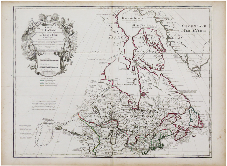
L'ISLE (Guillaume de) & DEZAUCHE (Jean-Claude).
Carte du Canada qui comprend la partie septentrionale des États Unis d'Amérique.
Paris, Dezauche, 1783. 502 x 648 mm.
Bookseller reference : LBW-7216
|
|
|
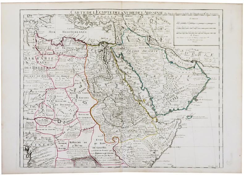
L'ISLE (Guillaume de).
[AFRIQUE/ARABIE] Carte de l'Égypte de la Nubie de l'Abissinie.
Paris, chez l'auteur, 1707. 493 x 618 mm.
Bookseller reference : LBW-5479
|
|
|
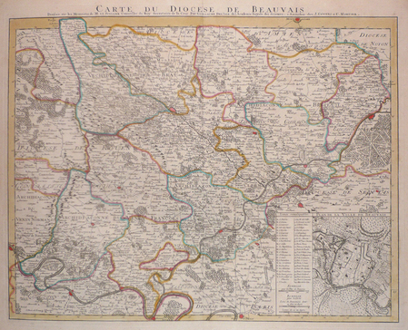
L'ISLE (Guillaume de).
[BEAUVAIS] Carte du diocèse de Beauvais.
Amsterdam, J. Covens et C. Mortier, [circa 1710]. 451 x 578 mm.
Bookseller reference : LBW03961
|
|
|
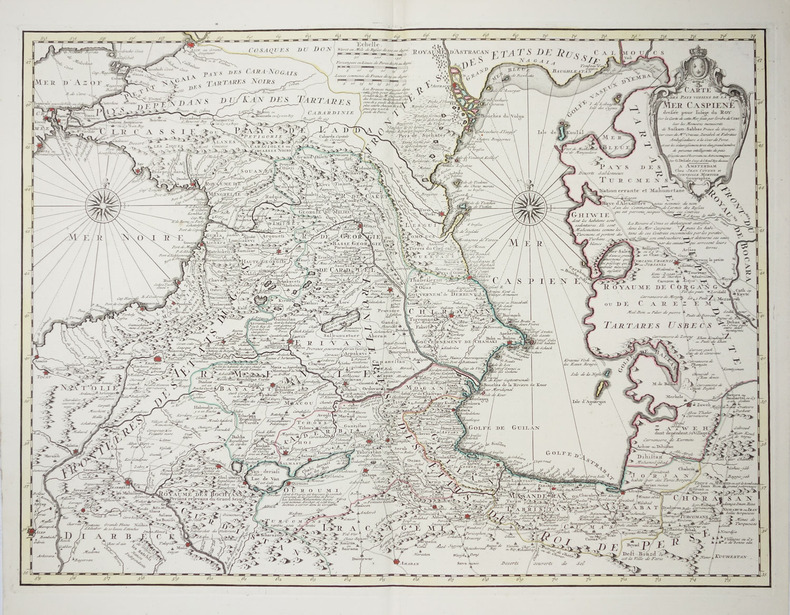
L'ISLE (Guillaume de).
[MER CASPIENNE] Carte des pays voisins de la mer Caspiene.
Amsterdam, Jean Covens et Corneille Mortier, [circa 1730]. 458 x 616 mm.
Bookseller reference : LBW-2256
|
|
|
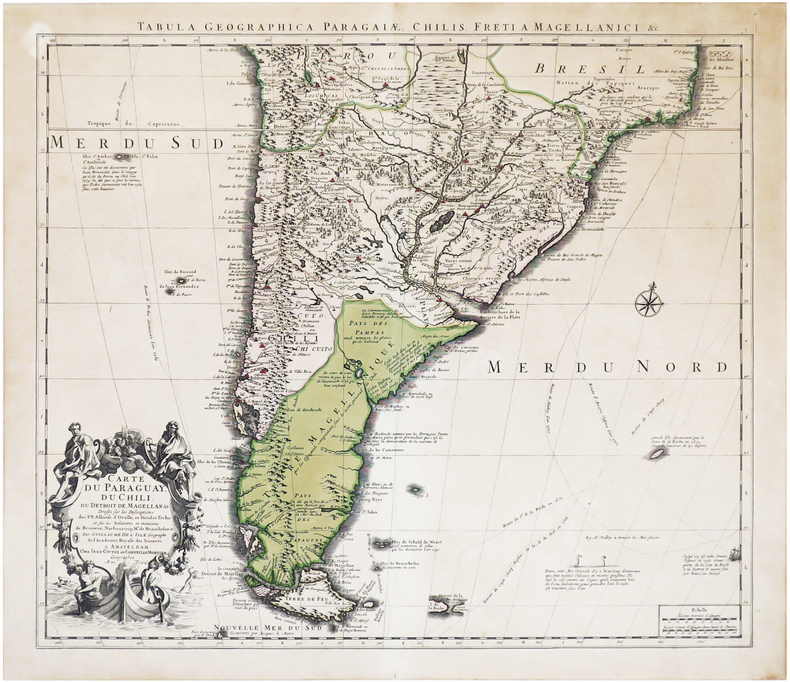
L'ISLE (Guillaume de).
[PARAGUAY/CHILI] Carte du Paraguay, du Chili, du détroit de Magellan &c.
Amsterdam, Jean Covens et Corneille Mortier, [circa 1720]. 497 x 577 mm ; contrecollée sur carton.
Bookseller reference : LBW-7015
|
|
|
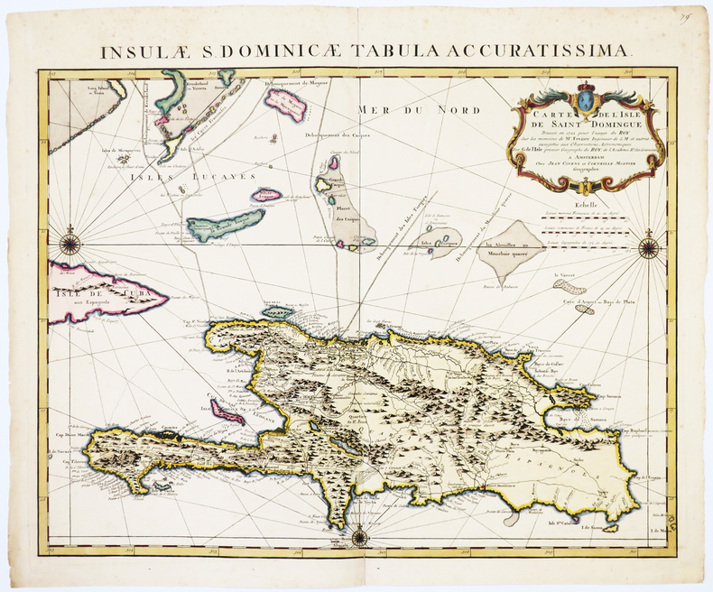
L'ISLE (Guillaume de).
[SAINT-DOMINGUE] Carte de l'isle de Saint Domingue dressée en 1722 pour l'usage du roy sur les mémoires de Mr. Frézier.
Amsterdam, Jean Covens et Corneille Mortier, [circa 1740]. 485 x 605 mm.
Bookseller reference : LBW-1730
|
|
|
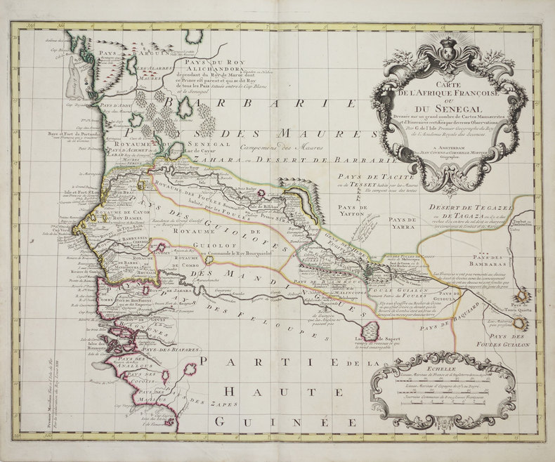
L'ISLE (Guillaume de).
[SENEGAL] Carte de l'Afrique françoise ou du Sénégal.
Amsterdam, Jean Covens et Corneille Mortier, [1726-1730]. 493 x 620 mm.
Bookseller reference : LBW-3179
|
|
|
L'ISLE (Guillaume de).
[SENLIS] Carte topographique du diocèse de Senlis.
Amsterdam, J. Covens et C. Mortier, [circa 1710]. 463 x 609 mm.
Bookseller reference : LBW03962
|
|
|
L'ISLE (Guillaume de).
Carte d'Amérique dressée pour l'instruction.
Paris, chez l'auteur, 1790. 480 x 595 mm.
Bookseller reference : LBW-5411

|
|
|
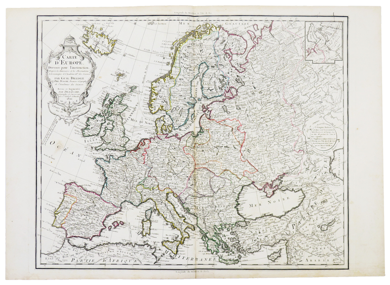
L'ISLE (Guillaume de).
Carte d'Europe dressée pour l'instruction. D'après les itinéraires et les observations astronomiques de l'Académie R.le des Sciences.
Paris, chez l'auteur, 1800. 511 x 617 mm.
Bookseller reference : LBW-5398
|
|
|
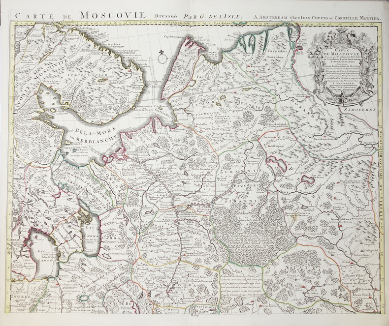
L'ISLE (Guillaume de).
Carte de Moscovie - Partie méridionale de Moscovie.
Amsterdam, Jean Covens et Corneille Mortier, circa 1740. En deux feuilles non jointes pouvant former une carte d'environ 980 x 620 mm.
Bookseller reference : LBW-2276
|
|
|
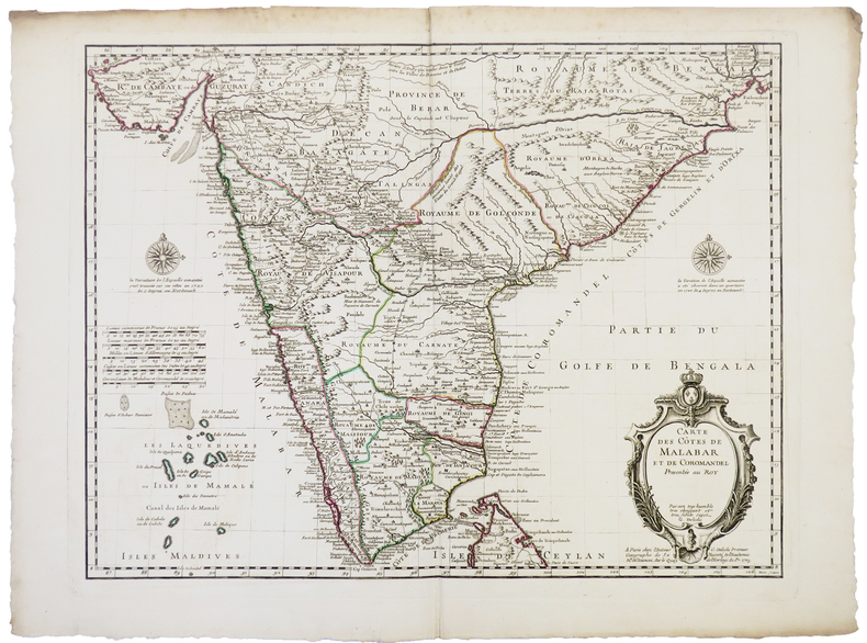
L'ISLE (Guillaume de).
Carte des côtes de Malabar et de Coromandel.
Paris, chez l'auteur, 1723. 442 x 577 mm.
Bookseller reference : LBW-5382
|
|
|
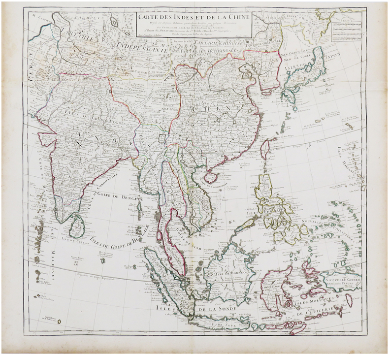
L'ISLE (Guillaume de).
Carte des Indes et de la Chine.
Paris, Dezauche, 1781. En deux feuilles jointes de 630 x 657 mm.
Bookseller reference : LBW-7187
|
|
|
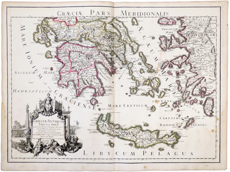
L'ISLE (Guillaume de).
Græciæ antiquæ tabula nova. Græciæ pars meridionalis.
Paris, chez l'auteur, 1707. 467 x 648 mm.
Bookseller reference : LBW-5235
|
|
|
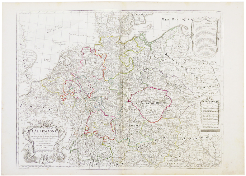
L'ISLE (Guillaume de).
L'Allemagne dressée sur les observations de Tycho-Brahé, de Kepler, de Snellius.
Paris, Dezauche, 1788. 488 x 630 mm.
Bookseller reference : LBW-5409
|
|
|
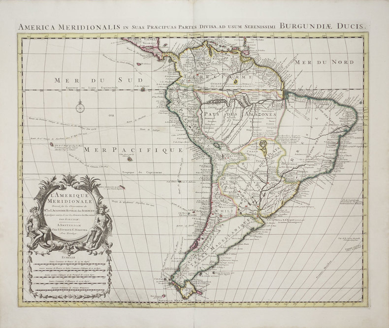
L'ISLE (Guillaume de).
L'Amérique méridionale - America meridionalis in suas præcipuas partes divisa, ad usum serenissimi Burgundiæ Ducis.
Amsterdam, J. Covens & C. Mortier, [1700-1730]. 471 x 582 mm.
Bookseller reference : LBW-3167
|
|
|
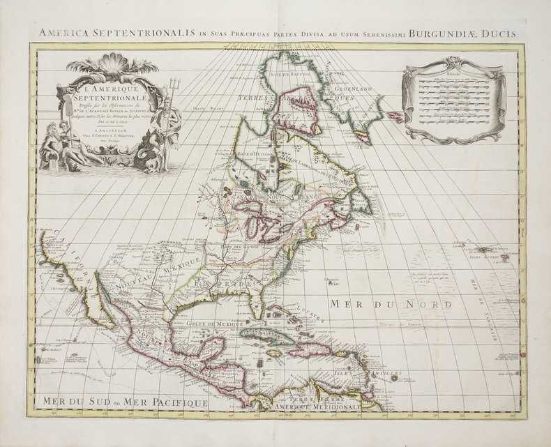
L'ISLE (Guillaume de).
L'Amérique septentrionale - America septentrionalis in suas præcipuas partes divisa, ad usum serenissimi Burgundiæ Ducis.
Amsterdam, J. Covens & C. Mortier, [1700-1730]. 466 x 582 mm.
Bookseller reference : LBW-3285
|
|
|
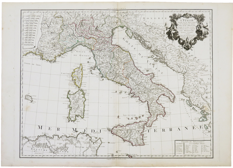
L'ISLE (Guillaume de).
L'Italie dressée sur les observations de l'Académie des Sciences.
Paris, Dezauche, An XI-1802. 490 x 618 mm.
Bookseller reference : LBW-5391
|
|
|
L'ISLE (Guillaume de).
Les Isles Britanniques.
Paris, Dezauche, 1772. 474 x 618 mm.
Bookseller reference : LBW-5407

|
|
|
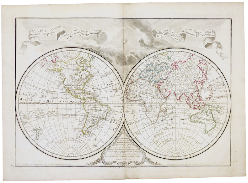
L'ISLE (Guillaume de).
Mappemonde à l'usage de l'instruction.
Paris, Dezauche,1800. 455 x 658 mm.
Bookseller reference : LBW-5393
|
|
|
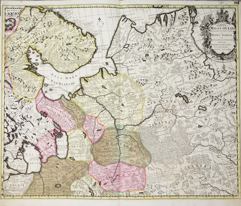
L'ISLE (Guillaume de).
Tabula Moscoviae nunc accuratius concinnata et edita a Petro Schenk.
Amsterdam, Pierre Schenk, circa 1710. En deux feuilles non jointes pouvant former une carte d'environ 975 x 607 mm.
Bookseller reference : LBW-2273
|
|
|
L'ISLE (Guillaume de);
[BEZIERS] Carte du diocèse de Béziers.
Amsterdam J. Covens et C. Mortier circa 1710 450 x 574 mm.
Bookseller reference : LBW03941

|
|
|
L'ISLE (Guillaume de, ou DELISLE).
Carte d'Europe dressée pour l'usage du Roy [sic] sur les itinéraires anciens et modernes et sur les routiers de mer assujettis aux observations astronomiques.
A Paris, chez l'auteur, 1745. Dimensions : 618 x 498 (cuvette) + passe-partout + cadre.
Bookseller reference : 21113

|
|
|
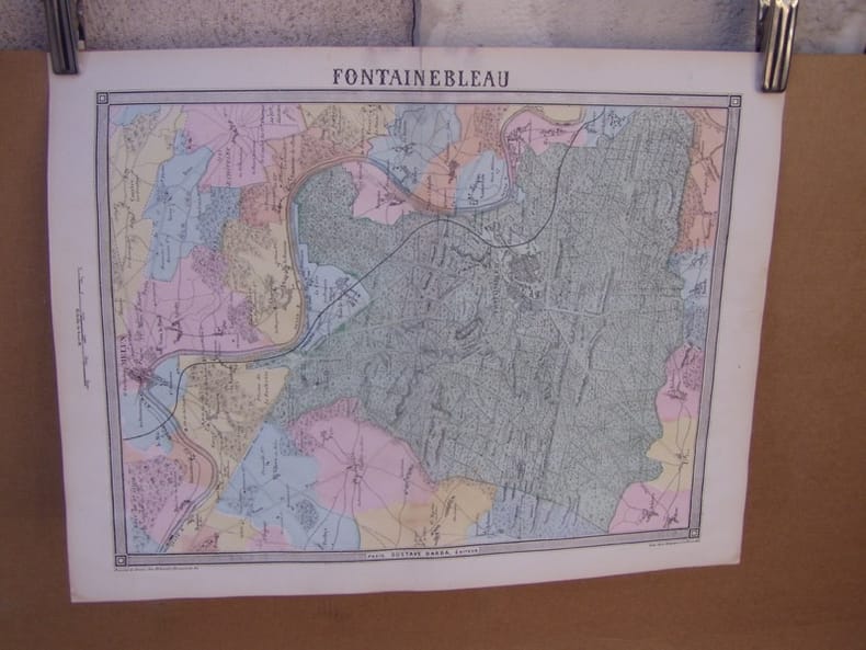
LA BEDOLLIERE (Emile de)
Fontainebleau, carte topographique couleurs sur double page dessinée et gravée par EHRARD, tirée de l'Histoire des environs du nouveau Paris.
1861 Edité par Paris, Gustave Barba, [s.d., 1861], 1861,pli central,bon état.
Bookseller reference : 27435
|
|
|
LA BEDOLLIERE (Emile de)
St-Germain,,carte topographique couleurs sur double page dessinée et gravées par EHRARD, tirée de l'Histoire des environs du nouveau Paris.
1861 Edité par Paris, Gustave Barba, [s.d., 1861], 1861,pli central,bon état.
Bookseller reference : 27433

|
|
|
LA BIBLE - SEGOND Louis 4 cartes en couleurs.
La Bible qui comprend l'ancien et le nouveau testament traduits d'après les textes originaux hébreu et grec.
Couverture rigide. Reliure rouge. Environ 1000 pages.
Bookseller reference : 143576

|
|
|
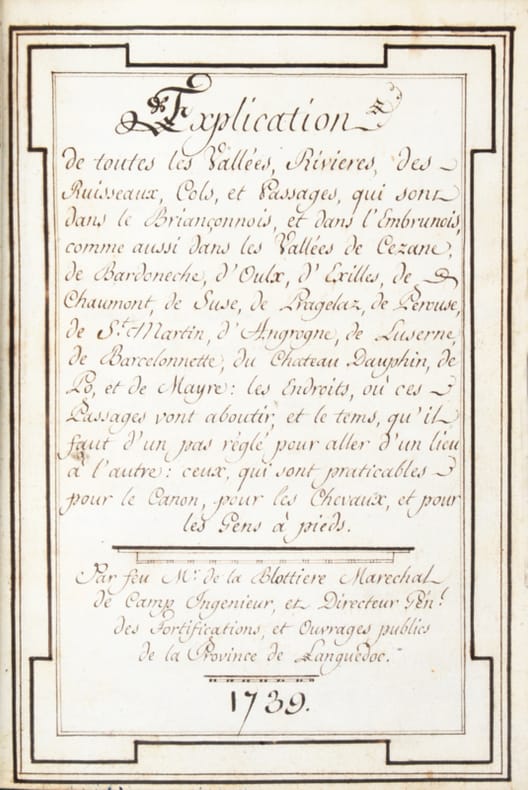
LA BLOTTIÈRE (François de).
[Dauphiné. Briançon. Embrun. Manuscrit]. Explication de toutes les Vallées, Rivières, des Ruisseaux, Cols et Passages qui sont dans le Briançonnois et dans l’Embrunois comme aussi dans les Vallées de Cezane, de Bardoneche, d’aulx, d’Exilles, de Chaumont, de Suse, de Pragelaz, de Perouse, de St Martin, d’Angrogne, de Luserne, de Barcelonnette, du Château Dauphin, de Po et de Mayre : les Endroits où ces Passages vont aboutir et le temps qu’il faut d’un pas réglé pour aller d’un lieu à l’autre : ceux qui sont praticables et pour le Canon pour les Chevaux et pour les Gens à pieds. Par feu Mr. de la Blottière Maréchal de Camp Ingénieur et Directeur Pen. des Fortifications et Ouvrages publics de la Province de Languedoc. 1739.
, , 1790 ca. In-12 manuscrit (11 x 16 cm) à 20 lignes par page de (1)-87 pp. à l’encre brune, texte encadré, basane fauve, dos lisse orné, frise dorée d'encadrement sur les plats, fleuron dans les angles (reliure de la fin du XVIIIe siècle).
Bookseller reference : 42184
|
|
|
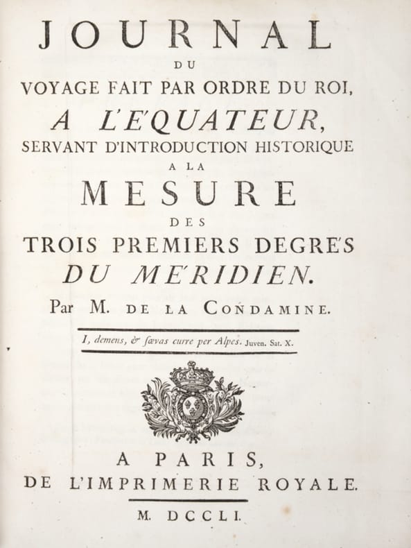
LA CONDAMINE (Charles-Marie de)
Journal du voyage fait par ordre du Roi à l'Equateur servant d'Introduction historique à la mesure des trois premiers degrés du Méridien
Paris, Imprimerie Royale, 1751. In-4, veau marbré, dos à nerfs orné avec pièce de titre, filets aux plats, XXXvj +280 pages + XV pages - illustré de deux cartes dépliantes, quatre planches dont trois dépliantes et un tableau dépliant. Reliure avec usures, quelques épidermures, mors avec fentes et frottements, coins émoussés, quelques taches et piqures éparses, déchirure à la carte pliante de la Province de Quito au Pérou sinon bon état intérieur
Bookseller reference : PHO-1682

|
|
|
LA CONDAMINE (Charles-Marie de).
Journal du voyage fait par ordre du Roi, a l'Équateur, servant d'introduction historique à la Mesure des trois premiers degrés du Méridien. Paris, Imprimerie Royale, 1751. In-4 de (2)-xxxvi-280-xv pp., 2 cartes et 5 planches hors texte repliées. LA CONDAMINE (Charles Marie de). Mesure des trois premiers degrés du Méridien dans l'Hémisphère austral, tirée des observations de MM. de l'Académie royale des sciences, envoyés par le roi sous l'Équateur, par M. de La Condamine.
Paris, Imprimerie Royale, 1751. In-4 de (12)-266-X-VIII pp., 3 planches hors texte dont 2 dépliantes.Les deux pièces reliées en 1 vol. in-4, veau marbré, dos orné à nerfs, pièce de titre en maroquin rouge, triple filet doré d'encadrement sur les plats, tranches dorées sur marbrure (reliure de l'époque).
Bookseller reference : 42132
|
|
|
LA CONDAMINE, Charles Marie de.
Relation abrégée d'un voyage fait dans l'intérieur de l'Amérique méridionale, depuis la côte de la mer du sud, jusqu'aux côtes du brésil et de la Guyane, en descendant la rivière des Amazones.
Maestricht, Jean-Edme Dufour & Philippe Roux, 1778. In-8°, pleine marge : [4]-xvi-379 pp.; 2 h.-t. , brochage d’attente, illustré d’une gravure et d’une carte les deux dépliantes, mouillures, Papier bruni.
Bookseller reference : PHO-1745

|
|
|
LA CONDAMINE, M. de
A Succinct Abridgment of a Voyage made within the Inland Parts of South America from the Coasts of the South Sea to the Coasts of Brazil & Guiana, down the River of Amazonas
8vo [22 x 13.5 cm]; xii, 108 pp, folding engraved map, with the half title page. contemporary marbled boards, leather spine, covers worn, joints repaired with leather, lacks front blank endpaper, map with old one inch tear repaired, interior is very good. A picture of this book is available upon request by email. Sabin 38488. A French-Spanish expedition was sent to South America in 1736, to measure a degree of latitude in the area near Quito where the equator crossed, to determine the size and shape of the earth. The ten year expedition proved that the earth is flattened at the Poles. La Condamine returned by crossing Brazil via the Amazon. His narrative of his journey was of great importance, because for the first time the long course of the Amazon was traversed by a man of science capable of making astronomic observations, and determining longitudes.' [Borba de Moraes, I, 447] The fine engraved map of the Amazon and its tributaries accompanying the text was drawn by La Condamine himself, and is the first map in which the latitudes were observed and shown on the map. Cox ii, 273: 'La Condamine returned to the east coast of the continent by descending the Amazon, the first time it was accomplished by a scientist'. Hill 169: 'the greatest geographical event of the eighteenth century as regards South America. . . to measure one exact degree of meridian to determine the dimensions and shape of the earth. . . the work occupied eight years'. Goodman 495: 'A very useful abridgment of this indispensible work, entirely satisfactory for nearly all purposes'. Spain & Spanish America I, 369.
|
|
|
LA CONDAMINE, M. de
A Succinct Abridgment of a Voyage made within the Inland Parts of South America from the Coasts of the South Sea to the Coasts of Brazil & Guiana, down the River of Amazonas
8vo [21x 13 cm]; xii, 108 pp, folding engraved map, with the half title page. contemporary full leather, spine worn, joints repaired, light foxing including on map, but mostly marginal, internally clean and very good. A picture of this book is available upon request by email. Sabin 38488. A French-Spanish expedition was sent to South America in 1736, to measure the degree of latitude in the area near Quito where the equator crossed, to determine the size and shape of the earth. The ten year expedition proved that the earth is flattened at the Poles. La Condamine returned by crossing Brazil via the Amazon. His narrative of his journey was of great importance, because, for the first time, the long course of the Amazon was traversed by a man of science capable of making astronomic observations, and determining longitudes.' [Borba de Moraes, I, 447] The fine engraved map of the Amazon and its tributaries accompanying the text was drawn by La Condamine himself, and is the first map in which the latitudes were observed and shown on the map. Cox ii, 273: 'La Condamine returned to the east coast of the continent by descending the Amazon, the first time it was accomplished by a scientist'. Hill 169: 'the greatest geographical event of the eighteenth century as regards South America. . . to measure one exact degree of meridian to determine the dimensions and shape of the earth. . . the work occupied eight years'. Goodman 495: 'A very useful abridgment of this indispensable work, entirely satisfactory for nearly all purposes'. Spain & Spanish America I, 369.
|
|
|
LA CONDAMINE, M. de
Relation Abregee D'un Voyage Fait Dans L'interieur De L'amerique Meridionale. Depuis La Cote De La Mer du Sud, Jusqu'aux Cotes du Bresil & De La Guiane, En Descendant La Riviere Des Amazones [Voyage made within the Inland Parts of South-America . . .]
8vo [20.5 x 13 cm]; xvi, 216, [iv, privege du roi] pp, folding engraved map, errata. contemporary full tree calf, gilt spine title lettering on leather label, gilt spine decorations, all edges gilted, marbled endpapers, corners and spine end worn, small inkstamp on title page, interior quite clean and fine, cover very good. A picture of t Sabin 38484. A French-Spanish expedition was sent to South America in 1736, to measure a degree of latitude in the area near Quito where the equator crossed, to determine the size and shape of the earth. The ten year expedition proved that the earth is flattened at the Poles. La Condamine returned by crossing Brazil via the Amazon. His narrative of his journey was of great importance, because for the first time the long course of the Amazon was traversed by a man of science capable of making astronomic observations, and determining longitudes.' [Borba de Moraes, I, 446] The fine engraved map of the Amazon and its tributaries accompanying the text was drawn by La Condamine himself, and is the first map in which the latitudes were observed and shown on the map. Cox ii, 272. Hill 168.
|
|
|
LA FAIRE (G. de).
Prise de la citadelle de Kinburn.
17 8bre [octobre] 1855 14,5 x 24 cm, sur une feuille de 21,5 x 43 cm pliée en deux.
Bookseller reference : LBW-6611

|
|
|
LA FERTE
Carte au 1/200 000e. Sans date.
Une feuille 32x50 cm.
|
|
|
LA GUERCHE
Carte couleur au 1/100 000?. Feuille IX-17. Mise ? jour 1923.
Une feuille 57x45 cm.
|
|
|
LA HARPE Jean-François de:
Abrégé de l'histoire générale des voyages, contenant ce qu'il y a de plus remarquable, de plus utile & de mieux avéré dans les pays ou les voyageurs ont pénétré; les moeurs des habitans, la religion, les usages, arts & sciences commerce, manufactures; enrichi de cartes géographiques & de figures.
Paris, Hôtel de Thou [et] Laporte, 1780 [et] 1786. 23 volumes in-8 et un volume in-4 pour l'atlas. Plein veau raciné brun, dos lisses ornés de filets et fleurons dorés, pièces de titre et tomaison en maroquin rouge. Accident de vers aux volumes 18 et 22, et une tache aux derniers feuillets du vol. 12. Menus défauts à quelques coiffes et quelques coins frottés.
Bookseller reference : 15445
|
|
 Receive by email
 Download as PDF document
 RSS feed


