|
DEVINAZ Danielle / JADOT Bernard
Villeurbanne autrefois.
Horvath 1988 Horvath, 1988, 160 p., broché. Dos un peu aplati vers le premier plat, page de titre annotée, quelques mots annotés sur une page de texte, bon état pour le reste.
Bookseller reference : 117055
|
|
|
Devos Roger
Vie et traditions populaires savoyardes : chablais, faucigny, genevois, tarentaise, maurienne.
Ed. du parc Horvath, 1991, un volume in 8 broché, 191 pages, abondante iconographie en n&b et en couleurs. Bibliographie, index. Très bon état.
Bookseller reference : 6448
|
|
|
DeVoto Bernard; Maps by Erwin Raisz
The Course of Empire
Norwalk CT: The Easton Press 1988. Collector's Edition. Leather bound. Very good. 647pp. Octavo 23 cm Dark green leather with raised bands a gilt stamped title on the spine and gilt stamped designs on the spine and covers. All edges gilt. Patterned endpapers. Publisher's Notes from History tucked in. A previous owner's Easton Press bookplate is mounted to the front pastedown. Part of The Leather-Bound Library of American History. The Easton Press unknown
Bookseller reference : 54300

|
|
|
DeVoto Bernard; Raisz Erwin maps by;
The Course of Empire
Boston: Houghton Mifflin and CompanyH 1952. Hardcover. Octavo; pp 647; VG-/G-; dark yellow spine with beige text; dust jacket has sunned spine; modest wear to exterior; some rubbing to edges; price clipped flap; mylar wrap; cloth has only light to exterior; clean strong boards; text block has slight foxing to exterior edges; pictorial endpapers; illustrated; deckled fore edge; tight binding;. 1329900. FP New Rockville Stock. Houghton, Mifflin and CompanyH hardcover books
Bookseller reference : 1329900
|
|
|
Dewdney, Selwyn
The Map That Grew
32 pages. A story which teaches young readers about mapmaking. Front free endpaper removed. Usual library markings. Worthy working copy. Book

|
|
|
DEWITTE, R.
CATALOGUE DES CARTES ET PLANS DE LA COLLECTION KAREL MESTDAGH.
, Bruges, Archives de l'Etat, 1935., Broche, couverture originale en vert, 16x24,5cm, 307pp.
Bookseller reference : 6597
|
|
|
DEYROLLE (Émile) & BERNARD (Albert).
Carte agricole n°9. Géographie économique et agricole. Animaux domestiques. Espèce bovine, ses produits.
Paris, Les Fils d'Émile Deyrolle, [1925]. 793 x 845 mm.
Bookseller reference : LBW-7229

|
|
|
DEZ.G
POITIERS EN CARTE POSTALES ANCIENNES
BIBLIOTHEQUE EUROPEENNE - ZALTBOMMEL. 1974. In-8. Relié. Bon état, Couv. convenable, Dos satisfaisant, Intérieur frais. environ 115 pages augmentées de nombreuses photos en noir et blanc, situées. . . A l'italienne. Classification Dewey : 741.68-Illustrations des cartes postales
Bookseller reference : R320099599
|
|
|
DEZ.G
POITIERS EN CARTE POSTALES ANCIENNES
BIBLIOTHEQUE EUROPEENNE - ZALTBOMMEL. 1974. In-8 Carré à l'italienne. Relié. Bon état. Couv. convenable. Dos satisfaisant. Intérieur frais. environ 115 pages augmentées de nombreuses photos en noir et blanc, situées
|
|
|
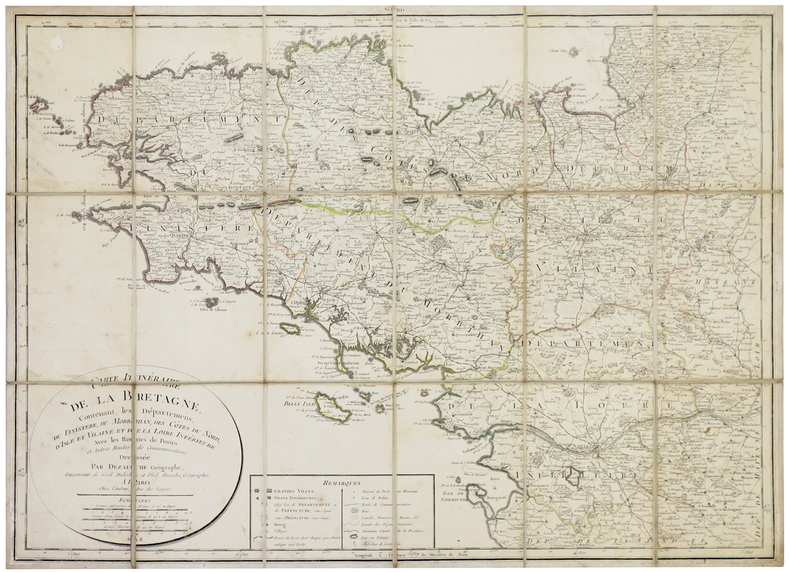
DEZAUCHE (Jean-Claude).
[BRETAGNE] Carte itinéraire de la Bretagne contenant les départemens du Finistère, du Morbihan, des Côtes du Nord, d'Isle et Vilaine et de la Loire Inférieure.
Paris, chez l'auteur, An 8 [1800]. En 18 sections montées sur toile et pliées, formant une carte de 528 x 716 mm.
Bookseller reference : LBW-5355
|
|
|
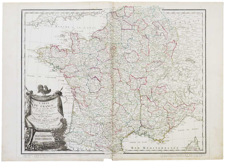
DEZAUCHE (Jean-Claude).
Carte de France suivant sa nouvelle division en CVIII départements, avec les préfectures et sous-préfectures.
Paris, chez l'auteur, An XI-1803. 510 x 621 mm.
Bookseller reference : LBW-5410
|
|
|
DEZAUCHE, J. C. ; DELISLE, Guillaume ; BUACHE, Philippe
Germania Antiqua in diversos populos qui eam coluerunt distincta. [ Carte de l'Allemagne sous l'Antiquité ]
Ex Itinerariis Locupletissimis que Antiquis Auctoribus, qui de hac Regione disseruerunt, et ex Mappis Geographicis Guillelmi Delisle Excerpta, 1 carte au format 83 x 58,5 cm, frontières rehaussées en couleur, Delisle et Buache, Dézauche, Paris, 1796 Bon état Latin

|
|
|
Dharma Maps
Mount Spokane State Park MAP
2011-06-01. Good. Ships with Tracking Number! INTERNATIONAL WORLDWIDE Shipping available. May not contain Access Codes or Supplements. May be re-issue. May be ex-library. Shipping & Handling by region. Buy with confidence excellent customer service! unknown
Bookseller reference : 0979413249 ISBN : 0979413249 9780979413247

|
|
|
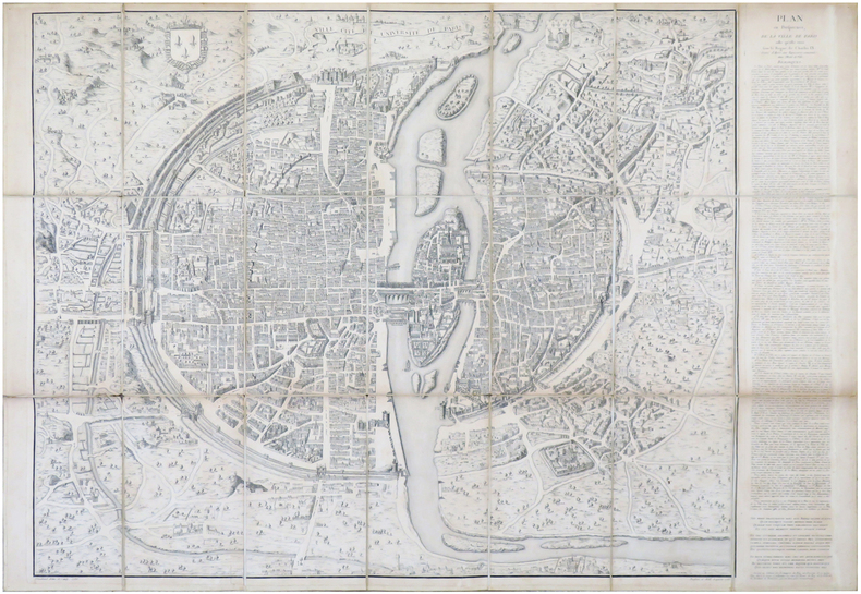
DHEULLAND (Guillaume) & ANDROUET du CERCEAU (Jacques).
Ville, Cité, et Université de Paris. Plan en perspective, de la ville de Paris telle qu'elle étoit sous le règne de Charles IX.
Paris, [1552-1756-milieu du XIXe]. En 21 sections montées sur toile et pliées, formant un plan de 694 x 991 mm ; étiquette au dos de l'éditeur Charles Simonneau.
Bookseller reference : LBW-6930
|
|
|
DHEULLAND (Guillaume).
[NOVARE] Environs de Novare et de Mortara.
Paris, 1748. 230 x 310 mm.
Bookseller reference : LBW002b2
|
|
|
DHEULLAND (Guillaume).
[SESTO/BIAGRASSO] Environs de Sesto, et de Biagrasso.
Paris, 1748. 230 x 310 mm.
Bookseller reference : LBW002b8
|
|
|
DHEULLAND (Guillaume);
[ALESSANDRIA/TORTONA] Environs d'Alessandrie, et de Tortone.
Paris 1748 230 x 310 mm.
Bookseller reference : LBW002af
|
|
|
DHEULLAND (Guillaume);
[BOBIO/PONTREMOLI] Environs de Bobio, et Pontremoli.
Paris 1748 230 x 310 mm.
Bookseller reference : LBW002ae
|
|
|
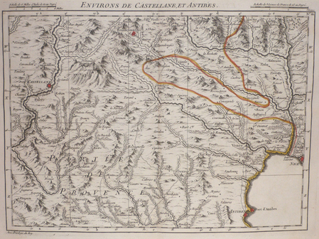
DHEULLAND (Guillaume);
[CASTELLANE/ANTIBES] Environs de Castellane, et Antibes.
Paris 1748 227 x 308 mm.
Bookseller reference : LBW004e3
|
|
|
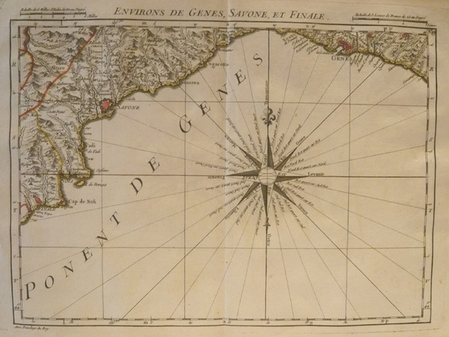
DHEULLAND (Guillaume);
[GENES] Environs de Gênes, Savone, et Finale.
Paris 1748 230 x 310 mm.
Bookseller reference : LBW002ac
|
|
|
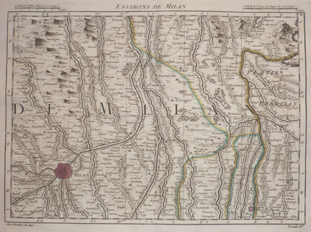
DHEULLAND (Guillaume);
[MILAN] Environs de Milan.
Paris 1748 230 x 310 mm.
Bookseller reference : LBW002b5
|
|
|
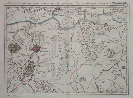
DHEULLAND (Guillaume);
[PAYS-BAS/BREDA] Carte particulière des environs de Breda et Geertruydenberg.
Paris 1747 227 x 305 mm.
Bookseller reference : LBW041a1
|
|
|
DHEULLAND (Guillaume);
[PAYS-BAS/LA HAYE] Carte particulière des environs de La Haye Leyden et Delft.
Paris 1747 227 x 306 mm.
Bookseller reference : LBW041a0
|
|
|
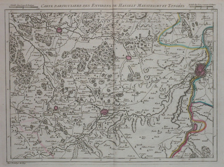
DHEULLAND (Guillaume);
[PAYS-BAS/MAASTRICHT] Carte particulière des environs de Hasselt Maestricht et Tongres.
Paris 1747 227 x 305 mm.
Bookseller reference : LBW04184
|
|
|
DHEULLAND (Guillaume);
[PAYS-BAS/ROTTERDAM] Carte particulière des environs de Rotterdam et Schiedam.
Paris 1747 225 x 303 mm.
Bookseller reference : LBW04168

|
|
|
DHEULLAND (Guillaume);
[PAYS-BAS/UTRECHT] Carte particulière des environs d'Utrecht Goude et Woerden.
Paris 1747 228 x 305 mm.
Bookseller reference : LBW0419f
|
|
|
DI MARIA (Yves).-
Guide pratique de la carte postale.
1981 Numéro Hors Série du "Collectionneur Français", 1981, in 4° broché, 70 pages ; importante iconographie ; couverture illustrée.
Bookseller reference : 79172
|
|
|
Diana Pe. Maps By Stephen Good
East Sussex Church Walks. 30 Walks to 70 Churches
London England: Pe Publishing. Very Good. 2009. 1st Paperback Edition. Soft Cover. 8vo - over 7�" - 9�" Tall Octavo 9780954369033 Softcover Softcover East Sussex Church Walks. 30 Walks to 70 Churches by Diana Pe. Maps By Stephen Good. We carry a wide selection of titles in The Arts Theology History Politics Social and Physical Sciences. academic and scholarly books and Modern First Editions Reference books and all types of Academic Literature. . Pe Publishing paperback
Bookseller reference : 104270 ISBN : 0954369033 9780954369033
|
|
|
DIAZ (Gérard)
Menu illustré d'une gravure originale signée.
Paris Société Les Amis Bibliophiles 1985 1 vol. Broché Menu dépliant sur Arches illustré d'une eau-forte (11.5 x 6.5 cm) signée par Gérard Diaz. En parfait état.
Bookseller reference : 109142
|
|
|
DIAZ (Gérard)
Menu illustré d'une gravure originale signée.
Paris Société Les Amis Bibliophiles 1985 1 vol. Broché Menu dépliant sur Arches illustré d'une eau-forte (11.5 x 6.5 cm) signée par Gérard Diaz. En parfait état.
Bookseller reference : 109142
|
|
|
DIAZ (Gérard).
Carte de voeux illustrée d'une gravure originale signée.
Paris Société des peintres-graveurs français 1986 1 vol. Broché Carte de voeux dépliante sur Arches illustrée d'une eau-forte (15 x 9 cm) signée et datée par Gérard Diaz. En parfait état.
Bookseller reference : 109092
|
|
|
DIAZ (Gérard).
Carte de voeux illustrée d'une gravure originale signée.
Paris Société des peintres-graveurs français 1986 1 vol. Broché Carte de voeux dépliante sur Arches illustrée d'une eau-forte (15 x 9 cm) signée et datée par Gérard Diaz. En parfait état.
Bookseller reference : 109092
|
|
|
DIAZ (Gérard).
Carte de voeux illustrée d'une gravure originale signée.
Paris Société des peintres-graveurs français 1995 1 vol. Broché Carte de voeux dépliante sur Arches illustrée d'une eau-forte en couleurs (diamètre 13 cm) signée par Gérard Diaz. En parfait état.
Bookseller reference : 109107
|
|
|
DIAZ (Gérard).
Menu illustré d'une gravure originale signée.
Paris Les Amis du livre contemporain et Automobile-Club de France 1993 1 vol. Broché Menu dépliant sur Arches illustré d'une eau-forte (27 x 21 cm) dédicacée par Gérard Diaz et justifiée 9/100. En parfait état.
Bookseller reference : 109109
|
|
|
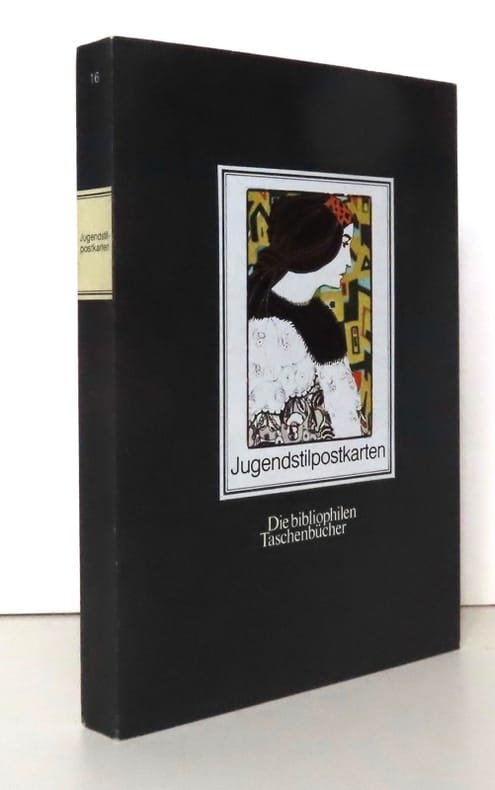
Dichand Hans:
Jugendstilpostkarten Die bibliophilen Taschenbücher.
Dortmund, Harenberg-Kommunikation, 1984 Carnet de cartes postales au format. . . carte postale. Infime trace de pli au second plat, pour le reste à l'état de neuf.
Bookseller reference : 20486
|
|
|
Dick Russell with maps by Eben given
EYE OF THE WHALE Epic Passage from Baja to Siberia
Simon & Schuster New York - ISBN:0684866080 2001 hardcover with dust jacket Twenty full-color photographs maps few b&w illustrations bibliography and index. Blue felt pen mark to bottom of pages. VERY GOOD book in VERY GOOD unclipped dust jacket This book shows the life-changing effect the gray whale has had upon people past and present - whalers hunters marine scientists whale watchers and even businessmen - who have looked into the eye of a whale and have come away transformed. Over the course of this astonishing book the gray whale emerges as a millennial metaphor mirroring a host of ecological political and social issues concerning our relationship with nature. A true story. Simon & Schuster, New York - ISBN:0684866080 hardcover
Bookseller reference : 2631 ISBN : 0684866080 9780684866086

|
|
|
Dickens, AG
The East Riding of Yorkshire with Hull and York
No marks or inscriptions. No creasing to covers or to spine. A lovely clean crisp very tight copy with bright boards and no bumping to corners. Slight browing to page edges. No dust jacket. 131pp. With twenty four black and white photographs. A character sketch of the old East Riding covering the land East of York, Malton and Selby, north of the Humber and reaching up to Filey on the coast.

|
|
|
Dickens, Charles
Nicholas Nickleby: Volume I
511 pages, illustrated, introduction by George Gissing, page edges foxed, top page edges gilt. eng
|
|
|
Dickens, Charles
Nicholas Nickleby: Volume II
viii,499 pages, illustrated by R.J. Williams, introduction by George Gissing, notes by F.G. Kitton, page edges foxed, top page edges gilt. eng
|
|
|
Didier Richard Maps
Pays du Mont-Blanc-Beaufortain, Avavis-Val D'Arly (FRANCAIS) Carte – Carte pliée, décembre 1997
Institut Geographique National (décembre 1997)
Bookseller reference : lc_10774
|
|
|
DIEPPE. MANUSCRIT.
Plan de Dieppe.
1730. 600 x 905 mm.
Bookseller reference : LBW-4156

|
|
|
DIERKENS Alain
Inventaires des cartes, plans et registres divers (fin XIXe - début XXe siècle).
Bruxelles, Archives Générales du Royaume, 1980. 20 x 29, 55 pp., broché, très bon état.
Bookseller reference : 21894
|
|
|
DIEULEFILS P.-
Carte postale annonce: Les Mangeurs de Poux en Famille. Tonkin. Hanoï. 659.-
La partie droite laissée libre de cette carte postale est utilisée à une annonce intitulée Étrennes utiles, proposant un joli album gratuit à tout acheteur d'une collection de 100 cartes postales au prix de 13 francs ou 6 piastres...Le petit mot adressé à un collectionneur précise qu'il s'agit de sa nouvelle collection. Hanoï. Photographie Dieulefils. Non datée, sans doute expédiée sous enveloppe. Carte postale (140 x90mm), cliché de 81 x 55mm, très net. Bel état.
Bookseller reference : ORD-3163
|
|
|
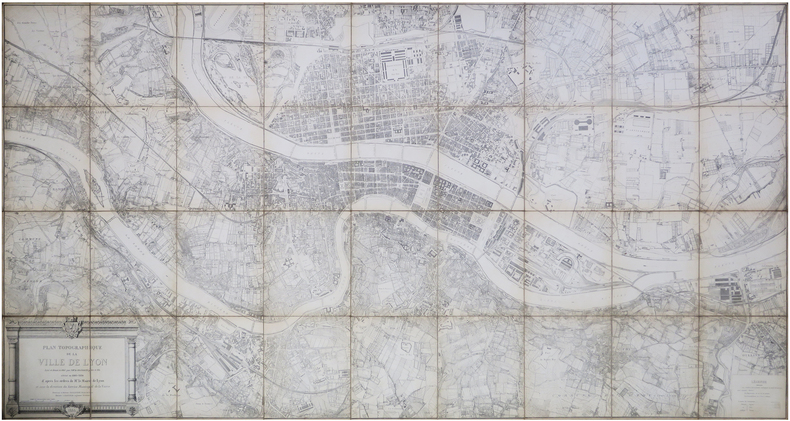
DIGNOSCYO (Laurent de) & DIGNOSCYO (Claude de).
[LYON] Plan topographique de la ville de Lyon levé et dressé en 1863 par M.M.rs Dignoscyo père et fils, révisé en 1883-1884.
1886. En 36 sections montées sur toile et repliées, formant un plan de 1,12 x 2,12 m.
Bookseller reference : LBW-8141
|
|
|
DIJON SUD-EST
Carte au 1/80 000e.
Une feuille 53,5x34,5 cm.
|
|
|
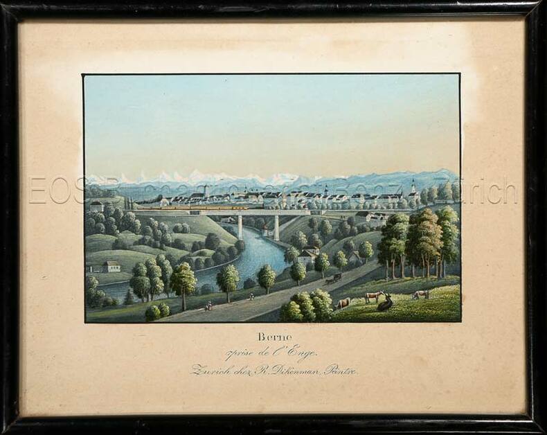
Dikenman, Johann Rudolf (1832-1888)
Berne prise de l'Enge.
Zürich, chez R. Dikenman, Peintre, um 1857. Kol. Aquatinta. Bildgrösse: 7,5 x 11,2 cm. Blattgrösse: 13 x 16 cm. + Wichtig: Für unsere Kunden in der EU erfolgt der Versand alle 14 Tage verzollt ab Deutschland / Postbank-Konto in Deutschland vorhanden +, Bild
Bookseller reference : 595BG

|
|
|
Dikenman, Johann Rudolf (1832-1888):
Berne prise de l'Enge.
Zürich, chez R. Dikenman, Peintre, um 1857. Kol. Aquatinta. Bildgrösse: 7,5 x 11,2 cm. Blattgrösse: 13 x 16 cm.
Bookseller reference : 595BG
|
|
|
Dilger, J.B
Die neue Pfarrkirche in der Vorstadt Au (heute in München).
(München, Jesef Deschler Verlag, um 1940. Altkolorierte Lithographie. Bildgrösse: 14,5 x 21,5 cm. Blattgrösse: 19 x 24 cm. + Wichtig: Für unsere Kunden in der EU erfolgt der Versand alle 14 Tage verzollt ab Deutschland / Postbank-Konto in Deutschland vorhanden +, Abb.
Bookseller reference : 769CG

|
|
 Receive by email
 Download as PDF document
 RSS feed


