|
DU PETIT-THOUARS (Louis-Marie Aubert).
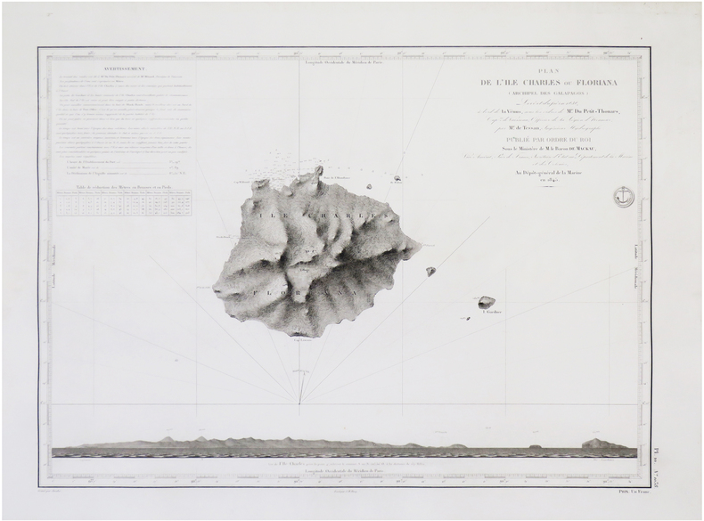
[GALÁPAGOS] Plan de l'île Charles ou Floriana (archipel des Galapagos).
[Paris], Dépôt-Général de la Marine, 1845. 425 x 585 mm.
Bookseller reference : LBW-7718
|
|
|
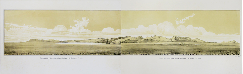
DU PETIT-THOUARS (Louis-Marie Aubert).
[HAWAII] Panorama de l'île d'Oahou pris du mouillage d'Honoloulou (Iles Sandwich).
[Paris, 1841]. En deux feuilles non jointes pouvant former un panorama d'environ 217 mm x 1,02 m.
Bookseller reference : LBW-1782
|
|
|
DU PETIT-THOUARS (Louis-Marie Aubert).
[KAMTCHATKA] Plan de la Baie d'Avatscha au Kamtschatka.
[Paris], Dépôt-Général de la Marine, 1844 [1845]. 600 x 423 mm.
Bookseller reference : LBW-7689

|
|
|
DU PETIT-THOUARS (Louis-Marie Aubert).
[MEXIQUE] Panorama, pris du mouillage de San Blas (côte occidentale du Mexique).
[Paris, 1841]. En quatre feuilles non jointes pouvant former un panorama d'environ 210 mm x 2,04 m.
Bookseller reference : LBW-1702

|
|
|
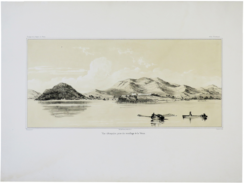
DU PETIT-THOUARS (Louis-Marie Aubert).
[MEXIQUE] Vue d'Acapulco, prise du mouillage de la Vénus.
[Paris, 1841]. 193 x 384 mm.
Bookseller reference : LBW-5674
|
|
|
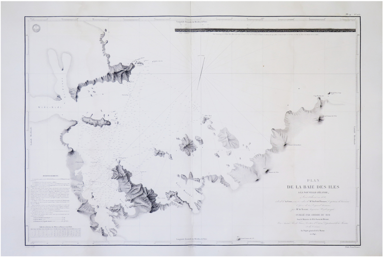
DU PETIT-THOUARS (Louis-Marie Aubert).
[NOUVELLE-ZÉLANDE] Plan de la Baie des Îles à la Nouvelle-Zélande.
[Paris], Dépôt-Général de la Marine, 1845. 605 x 861 mm.
Bookseller reference : LBW-7719
|
|
|
DU PETIT-THOUARS (Louis-Marie Aubert).
[PÉROU] Costumes de Lima (Pérou).
[Paris, 1841]. 227 x 250 mm.
Bookseller reference : LBW-5492

|
|
|
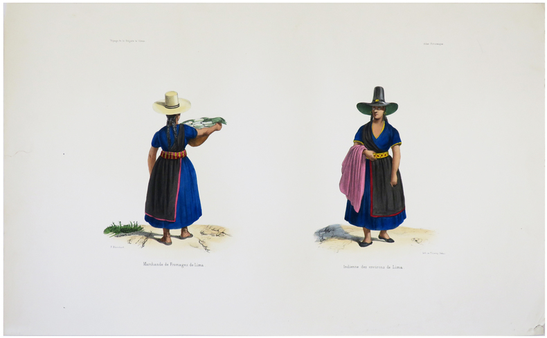
DU PETIT-THOUARS (Louis-Marie Aubert).
[PÉROU] Marchande de fromages de Lima - Indienne des environs de Lima.
[Paris, 1841]. 225 x 332 mm.
Bookseller reference : LBW-5493
|
|
|
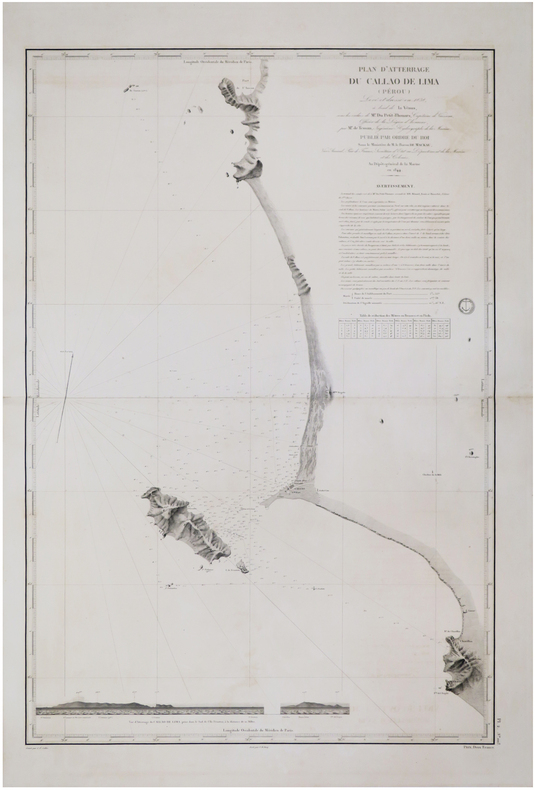
DU PETIT-THOUARS (Louis-Marie Aubert).
[PÉROU] Plan d'atterrage du Callao de Lima (Pérou).
[Paris, 1845]. 880 x 594 mm.
Bookseller reference : LBW-7547
|
|
|
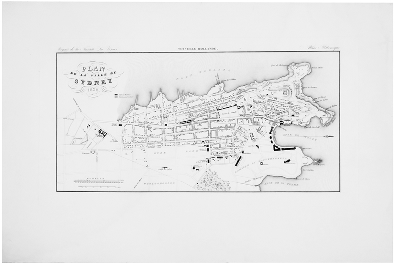
DU PETIT-THOUARS (Louis-Marie Aubert).
[SYDNEY] Plan de la ville de Sydney 1838.
[Paris, 1841]. 196 x 380 mm.
Bookseller reference : LBW-5872
|
|
|
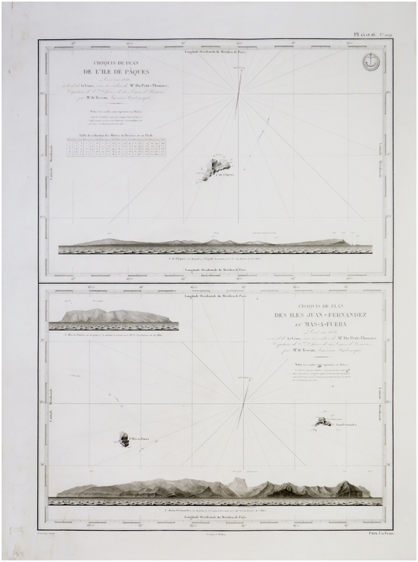
DU PETIT-THOUARS (Louis-Marie Aubert).
[ÎLES de PÂQUES & JUAN FERNANDEZ/CHILI] Croquis de plan de l'île de Pâques - Croquis de plan des îles Juan Fernandez et Mas-a-Fuera.
[Paris, Dépôt-Général de la Marine], 1845. 600 x 420 mm.
Bookseller reference : LBW-7696
|
|
|
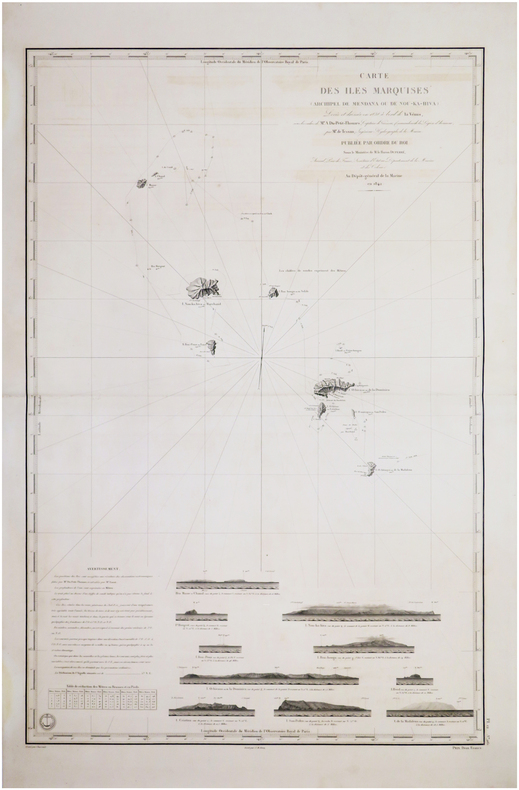
DU PETIT-THOUARS (Louis-Marie Aubert).
[ÎLES MARQUISES/POLYNÉSIE FRANCAISE] Carte des îles Marquises (archipel de Mendana ou de Nou-Ka-Hiva).
[Paris], Dépôt-Général de la Marine, 1842 [1845. 882 x 590 mm.
Bookseller reference : LBW-7576
|
|
|
Du PINET Antoine (1510 - 1584 circa)
Description de la Cité de Romme
Rarissima pianta prospettica della città, sconosciuta ai principali repertori sulle piante di Roma e pubblicata per la prima volta in Marigliani (2007).Si tratta di una copia della pianta del Munster senza alcun aggiornamento e ritrae la città come si presentava alla fine del '400 attingendo al medesimo prototipo comunemente indicato nel panorama di Mantova a sua volta ripreso da un presunto ma tuttora sconosciuto panorama inciso nella bottega di Francesco Rosselli verso il 1485. Tavola tratta dal rarissimo "Plantz, pourtraitz et descriptions de plusieurs villes et forteresses, tant de l'Europe, Asie, & Afrique, que des Indes, & terres neuves: Leurs fondations, antiquitez, & manieres de vivre: Avec plusieurs cartes generales & particulieres, servans à la Cosmographie, iointes à leurs declarations: deux tables fort amples, l'une des chapitres, & l'autre des matieres contenues en ce present livre. Le tout mis par ordre, region par region, par Antoine du Pinets" stampato a Lione dall’editore Jean d’Ogerolles. L'opera, che contiene 55 tavole silografiche - molte dele quali derivanti da Muenster - include il mondo cordiforme sul modello di Appiano, le mappe di europa e Germania e 18 vedute a doppia pagina delle primcipali città del tempo.La veduta di Roma deriva da quella pubblicata sempre a Lione nel 1552 da Guillaume Guéroult nel "Premier livre des figures et portraitz des villes", edita da Balthazar Arnouellet, da cui d’Ogerolles acquisì parte del fondo tipografico. Pertanto possiamo affermare che questa matrice in legno sia la stessa stampata alcuni anni prima, alla quale furono apportate delle correzioni nella cornice e nel titolo. Xilografia, in perfetto stato di conservazione. Rarissima. A very rare map of Rome, unknown by mostly of the repertoiries. The view depicts the city as it was at the end of the 15th century, drawing on the same prototype commonly indicated in the panorama of Mantua in turn taken from a still unknown panorama engraved in the workshop of Francesco Rosselli around 1485.Work taken from the very rare "Plantz, pourtraitz et descriptions de plusieurs villes et forteresses, tant de l'Europe, Asie, & Afrique, que des Indes, & terres neuves: Leurs fondations, antiquitez, & manieres de vivre: Avec plusieurs cartes generales & particulieres, servans à la Cosmographie, iointes à leurs declarations: deux tables fort amples, l'une des chapitres, & l'autre des matieres contenues en ce present livre. Le tout mis par ordre, region par region, par Antoine du Pinets" printed in Lyon by Jean d’Ogerolles. The work include 55 woodcuts, many after Munster, comprising 3 double-page maps (cordiform world after Apianus, Europe and Germany), 7 half-page maps, 18 double-page views (including Lyon, Bordeaux, Geneva, Frankfurt, Florence, Venice, Rome, Constantinople, Jerusalem, Cusco and others), and 27 illustrations (including Mexico city).The view is inspired to Guillame Guéroult’s "Premier livre des figures et portraitz des villes", published in 1552 by Balthazar Arnouellet. From him, d’Ogerolles bought many plates, therefore we can state that this block had been already used many years before and has then undergone some changes before being reprinted. Woodcut, in excellent condition. Valerio pp. 33/34; C. Marigliani, "Le Piante di Roma delle collezioni private", tav. 18

|
|
|
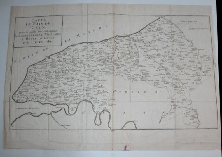
DU PLESSIS (Dom Toussaints).
Carte du Pays de Caux dans la quelle sont distinguez le Gouvernement Militaire du Havre de Grace et le Comté d'Eu.
Paris, Giffard, 1740. Carte gravée en noir, 64 x 45 cm, trace de pliures.
Bookseller reference : 16272
|
|
|
Du Val P.
Coste de Guayane autrement France �quinoctiale en la terre-ferme d'Am�rique suivant les derni�res relations
Paris: Chez l'auteur 1664. Unbound map. Good/No Jacket. Map 27 x 34 cm. Shows the coastal area from the Orinoco to the Amazon with an inset map of Ile de Cayenne. Legendary Lac Parime shown in southern area. Printed in black and hand colored. Creased along middle vertical fold otherwise unworn and unmarked Chez l'auteur unknown
Bookseller reference : 899999

|
|
|
DUBOIS (M.) - SIEURIN (E.)
Cartes d'étude pour servir à l'Enseignement de la Géographie. Géographie générale, Océanie, Afrique, Amérique. 40 cartes et 210 cartons.
Paris, Masson, 1903. In-8 (290x230mm) relié en cartonnage d'éditeur, np. Très bon état intérieur, extérieur présentant quelques salissures.
Bookseller reference : 21570
|
|
|
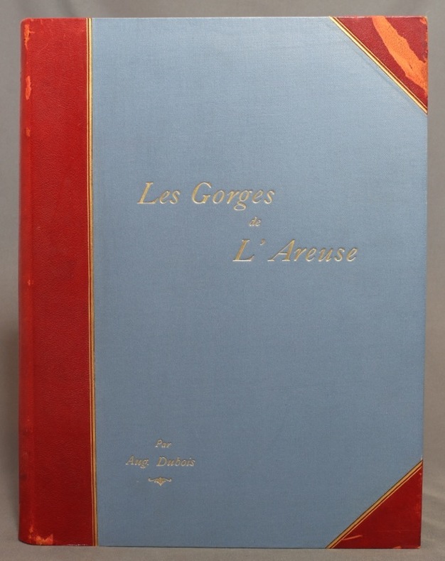
DUBOIS Auguste:
Les gorges de l’Areuse et le Creux du Van.
Neuchâtel, Attinger Frères, 1902. In-4 de [10]-227 pages, demi-maroquin rouge à coins, dos lisse (muet), titre doré au premier plat, doubles filets dorés sur les deux plat, couverture conservée.
Bookseller reference : 1195
|
|
|
DUBOIS Auguste:
Les gorges de l’Areuse et le Creux du Van.
Neuchâtel, Attinger Frères, 1902. In-4 de [8]-227 pages, demi-maroquin bordeaux, plats de percaline rouge, tranches marbrées, dos lisse avec titre doré et filets dorés et à froid.
Bookseller reference : 14046

|
|
|
DUBOIS, Georges - DUBOIS, Camille
La géologie de l'Alsace. Aperçu général et excursions géologiques.
Editions Université de Strasbourg, Mémoire n°13 du service de la carte géologique d'Alsace et de Lorraine, Publié avec le concours du centre national de la recherche scientifique - 1955 - In-4, broché - 312 pages - Figures hors-texte en N&B
Bookseller reference : 122331

|
|
|
Dubourg André
Collectionner, éditer des cartes postales
Encyclopédie des connaissances pratiques. 1987. In-8. Broché. Etat d'usage, Couv. convenable, Dos frotté, Intérieur acceptable. 67 pages - nombreuses photos et illustrations en noir et blanc dans et hors texte et planche dépliante en fin d'ouvrage.. . . . Classification Dewey : 741.68-Illustrations des cartes postales
Bookseller reference : R300302647

|
|
|
DUCHEMIN DESCEPEAUX J.
Lettres sur l’origine de la chouannerie et sur les chouans du Bas-Maine
dédiées au Roi Tome premier seul. In 8 demi-cuir glacé, vert, titre, tomaison, fers, filets, roulette, palmette dorés. Faux-titre, titre, V, 444 pages, imprimé par autorisation du Roi à l’imprimerie royale 1825. Edition originale, très bon état
Bookseller reference : 8764

|
|
|
Ducout, Fran oise
Cartes Postales de Chats
, Pierre Horay, 1984 Hardcover, +-100 pages, Texte en Francais, 320 x 240 mm, coin l g rement d chir sinon bon tat, illustrations en couleur / n/b. ISBN 9782705801403.
Bookseller reference : 60712
|
|
|
Ducout, Françoise
Cartes Postales de Chats
Hardcover, +-100 pages, Texte en Francais, 320 x 240 mm, coin légèrement déchiré sinon bon état, illustrations en couleur / n/b. ISBN 9782705801403.

|
|
|
Dudal R.,Osmond D. A.,Tavernier R.
Carte des sols de l'Europe, 1 / 2.500.000 (2 volumes)
Organisation des Nations Unies pour l'Alimentation et l'Agriculture Dos carré collé 1967 Deux volumes in-4 (23,5 x 29,5 cm), dont un volume de notice explicative dos carré collé (126 pages) et une chemise contenant les cartes en couleurs ; manque au dos en tête du livret de notice, quelques marques d'usage et rousseurs éparses, par ailleurs assez bon état. Livraison a domicile (La Poste) ou en Mondial Relay sur simple demande.
Bookseller reference : xa79
|
|
|
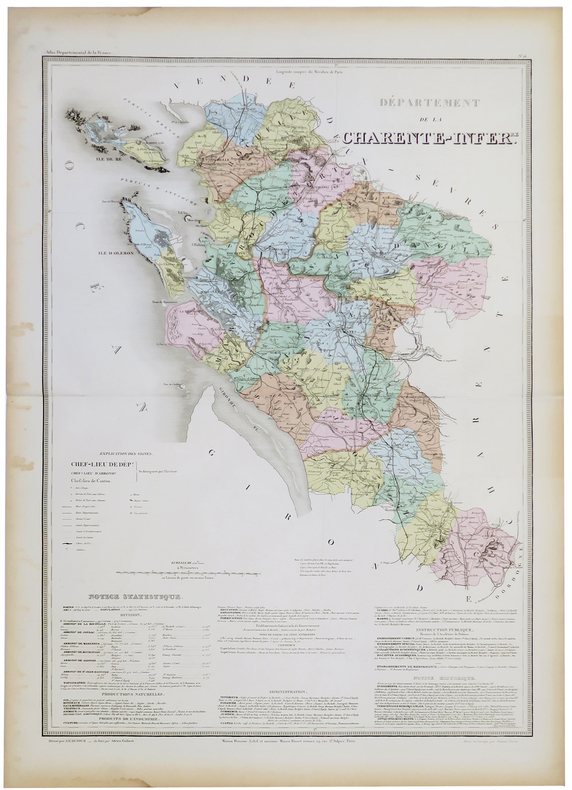
DUFOUR (Auguste-Henri).
[CHARENTE-MARITIME] Département de la Charente Infér.re.
Paris, Maison Bouasse-Lebel et ancienne Maison Basset réunies, [circa 1860]. 760 x 533 mm.
Bookseller reference : LBW-5327
|
|
|
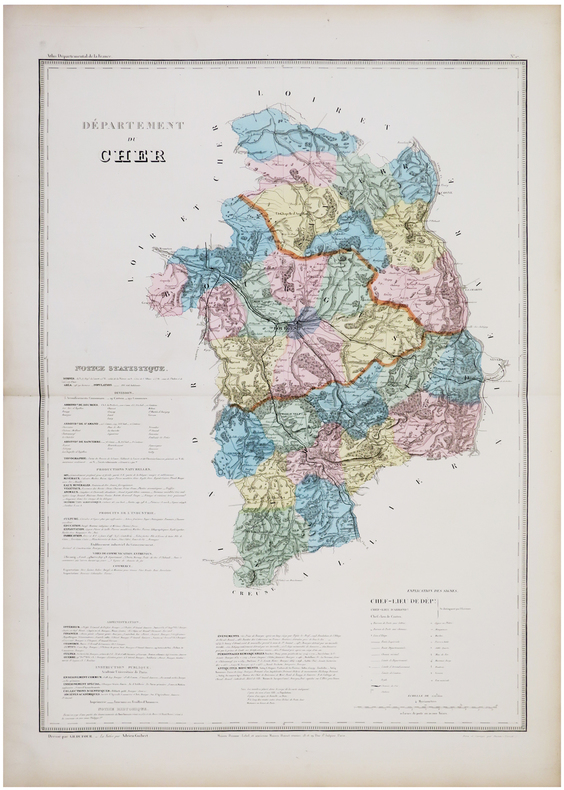
DUFOUR (Auguste-Henri).
[CHER] Département du Cher.
Paris, Maison Bouasse-Lebel et ancienne Maison Basset réunies, [circa 1860]. 753 x 529 mm.
Bookseller reference : LBW-5886
|
|
|
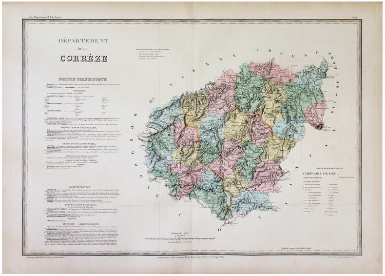
DUFOUR (Auguste-Henri).
[CORRÈZE] Département de la Corrèze.
Paris, Maison Bouasse-Lebel et ancienne Maison Basset réunies, [circa 1860]. 538 x 751 mm.
Bookseller reference : LBW-5911
|
|
|
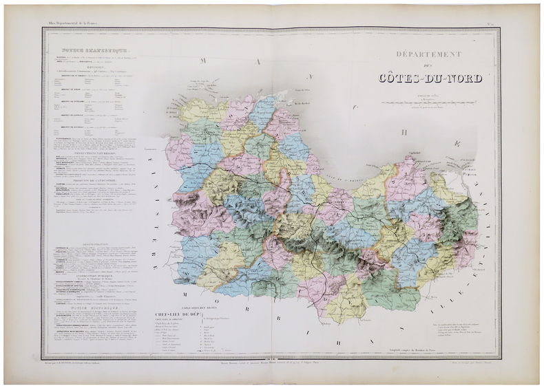
DUFOUR (Auguste-Henri).
[CÔTES-d'ARMOR] Département des Côtes-du-Nord.
Paris, Maison Bouasse-Lebel et ancienne Maison Basset réunies, [circa 1860]. 547 x 743 mm.
Bookseller reference : LBW-5328
|
|
|
DUFOUR (Auguste-Henri).
[FINISTÈRE] Département du Finistère.
Paris, Maison Bouasse-Lebel et ancienne Maison Basset réunies, [circa 1860]. 544 x 758 mm.
Bookseller reference : LBW-5331

|
|
|
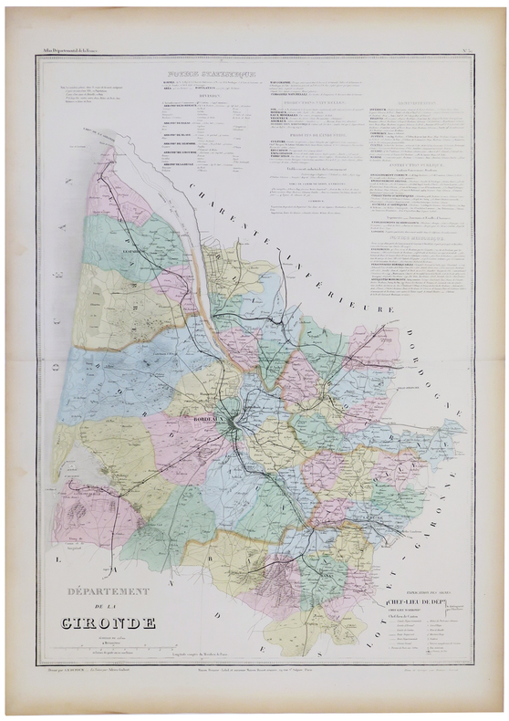
DUFOUR (Auguste-Henri).
[GIRONDE] Département de la Gironde.
Paris, Maison Bouasse-Lebel et ancienne Maison Basset réunies, [circa 1860]. 761 x 534 mm.
Bookseller reference : LBW-5332
|
|
|
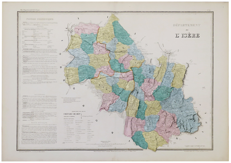
DUFOUR (Auguste-Henri).
[ISÈRE] Départements de l'Isère.
Paris, Maison Bouasse-Lebel, [circa 1860]. 540 x 748 mm.
Bookseller reference : LBW-5333
|
|
|
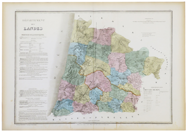
DUFOUR (Auguste-Henri).
[LANDES] Département des Landes.
Paris, Maison Bouasse-Lebel et ancienne Maison Basset réunies, [circa 1860]. 545 x 747 mm.
Bookseller reference : LBW-5334
|
|
|
DUFOUR (Auguste-Henri).
[LOIRE-ATLANTIQUE] Département de la Loire Inférieure.
Paris, Maison Bouasse-Lebel et ancienne Maison Basset réunies, [circa 1860]. 543 x 750 mm.
Bookseller reference : LBW-5335

|
|
|
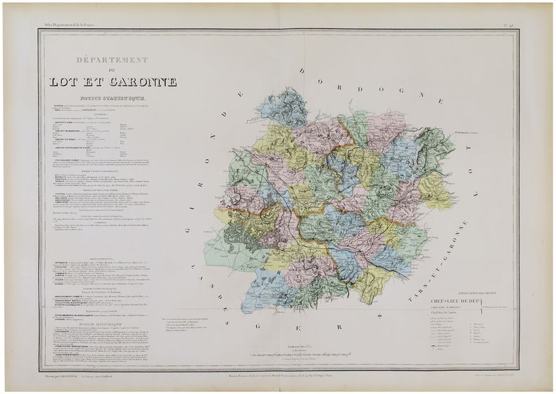
DUFOUR (Auguste-Henri).
[LOT-et-GARONNE] Département de Lot et Garonne.
Paris, Maison Bouasse-Lebel et ancienne Maison Basset réunies, [circa 1860]. 547 x 746 mm.
Bookseller reference : LBW-5925
|
|
|
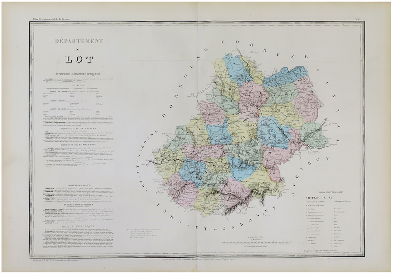
DUFOUR (Auguste-Henri).
[LOT] Département du Lot.
Paris, Maison Bouasse-Lebel et ancienne Maison Basset réunies, [circa 1860]. 542 x 748 mm.
Bookseller reference : LBW-5924
|
|
|
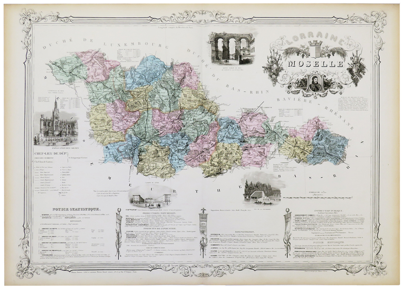
DUFOUR (Auguste-Henri).
[MOSELLE] Lorraine. Moselle.
Paris, Maison Bouasse-Lebel et ancienne Maison Basset réunies, [circa 1860]. 582 x 806 mm.
Bookseller reference : LBW-5339
|
|
|
DUFOUR (Auguste-Henri).
[NIÈVRE] Département de la Nièvre.
Paris, Maison Bouasse-Lebel et ancienne Maison Basset réunies, [circa 1860]. 540 x 746 mm.
Bookseller reference : LBW-5967

|
|
|
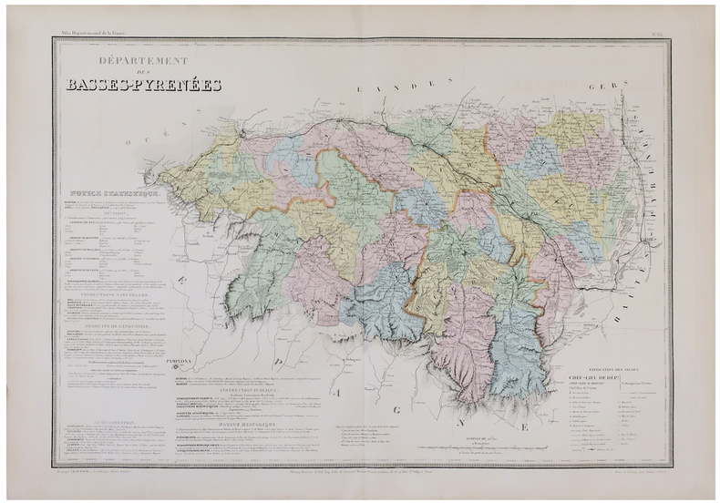
DUFOUR (Auguste-Henri).
[PYRÉNÉES-ATLANTIQUES] Département des Basses-Pyrénées.
Paris, Maison Bouasse-Lebel et ancienne Maison Basset réunies, [circa 1860]. 540 x 754 mm.
Bookseller reference : LBW-5883
|
|
|
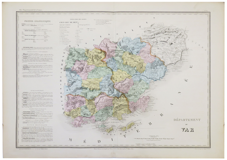
DUFOUR (Auguste-Henri).
[VAR] Département du Var.
Paris, Maison Bouasse-Lebel et ancienne Maison Basset réunies, [circa 1860]. 533 x 753 mm.
Bookseller reference : LBW-5344
|
|
|
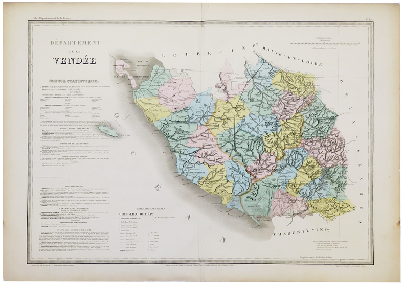
DUFOUR (Auguste-Henri).
[VENDÉE] Département de la Vendée.
Paris, Maison Bouasse-Lebel et ancienne Maison Basset réunies, [circa 1860]. 539 x 752 mm.
Bookseller reference : LBW-5345
|
|
|
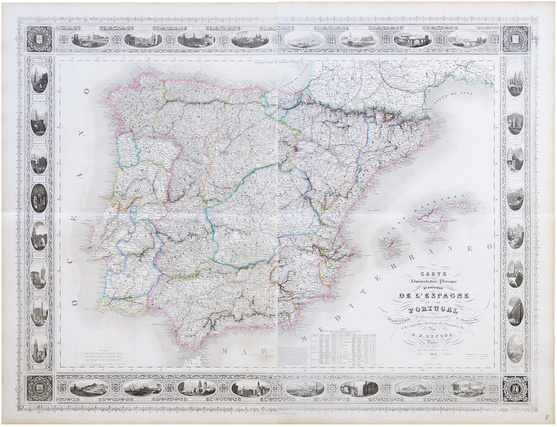
DUFOUR (Auguste-Henri).
Carte administrative, physique et routière de l'Espagne et du Portugal, indiquant les canaux, les rivières navigables, les chemins de fer, et les nouvelles divisions des provinces &c.
Paris, Bulla Frères, 1864. En deux feuilles pouvant être jointes pour former une carte de 0,95 x 1,25 m.
Bookseller reference : LBW-6823
|
|
|
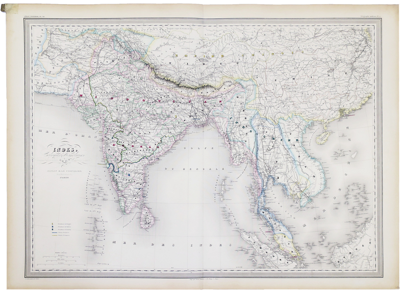
DUFOUR (Auguste-Henri).
Indes, Colonies anglaises.
Paris, Paulin et Le Chevalier, 1858. 554 x 753 mm.
Bookseller reference : LBW-5181
|
|
|
DUFOUR (Auguste-Henri);
Grèce moderne.
Paris Armand Le Chevalier 1863 555 x 754 mm.
Bookseller reference : LBW-1069

|
|
|
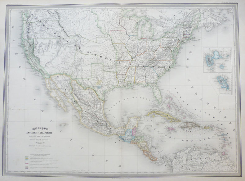
DUFOUR (Auguste-Henri);
Mexique Antilles et Californie.
Paris Paulin et Le Chevalier 1858 547 x 753 mm.
Bookseller reference : LBW-939
|
|
|
DUFOUR (Guillaume-Henri).
Carte hydrographique, itinéraire et administrative de l'Empire français, comprenant la Belgique et les provinces du Rhin et indisuant toutes les voies de communications ainsi que les limites des préfectures, sous-préfectures et cantons, dédiée à S.M. l'Empereur.
Lanée 1862 1 vol. en feuilles carte en couleurs entoilée (au format 154 x 152 cm), se repliant sous étui de percaline marine. Grande et belle carte de la France à l'échelle 1/700 000e. Quelques rousseurs au dos toilé, sans atteinte à la carte. Très bon état.
Bookseller reference : 52792
|
|
|
Dufour Guillaume Henri:
Carte Dufour - Fac-similé.
Wabern, Office fédéral de topographie, 1988. Etui au majestueux format de 42 x 60 cm. Bien complet des 25 planches, pliées en deux, au format 80 x 40 cm. A noter que la planche de titre fait partie des planches comptées, comme le confirme le feuillet de répartition des cartes.
Bookseller reference : 18327

|
|
|
DUFOUR Guillaume-Henri:
Campagne du Sonderbund et événements de 1856. Précédé d’une notice biographique.
Neuchâtel, Genève, Lib. J. Sandoz; Lib. Desrogis, 1876. In-8 de [2]-250-[2] pages, demi-basane brune,.
Bookseller reference : 6645
|
|
|
Dufour, Auguste Henri / Amari, Michele Benedetto Gaetano.
Carte de Sicilie dans son état actuel [...] Avec les réductions de la carte ancienne d'après Ptolémée et de la carte arabe d'après Edrisi. Paris, Lemercier, 1859.
Engraved map. 550 x 690 mm (image), 595 x 760 mm (sheet). Scale 1:519,210. 18 sections mounted on paper. Rare topographical map of Sicily, featuring two inset maps after Ptolemy and Al-Idrisi, allowing an immediate comparison of the depictions of the island in the 2nd, 12th, and 19th centuries. The main map identifies a remarkable number of towns and villages, including Palermo, Catania, Syracuse, Mazara, Caltanissetta, and Nicosia, as well as mountains, roads and paths. Two additional insets show Malta and the Aeolian Islands. Engraved by the German-French engraver and cartographer Erhard Schieble (1821-80). - Slightly foxed. Rarely seen at auction.
|
|
|
DUFOUR, Auguste-Henri y DUVOTENAY, Thunot.
El Globo. Atlas Histórico Universal de Geografía Antigua, de la Edad Media y Moderna.
Madrid, Biblioteca Ilustrada de Gaspar y Roig, Editores, 1852. 4to. mayor; 292 pp. de texto y 44 mapas dobles grabados en acero por Ramón Alabern, (de 46, faltando los correspondientes a Cuba y Chile - Perú). Encuadernación en media piel, de la época.

|
|
 Receive by email
 Download as PDF document
 RSS feed


