|
Pacific Northwest Maps Hayes Derek.
Historical Atlas of the Pacific Northwest: Maps of Exploration and Discovery British Columbia Washington Oregon Alaska Yukon.
Seattle::: Sasquatch Books 1999. 1570612153. A Fine copy in a Fine bright unclipped dust jacket. This volume provides a visual journey through four centuries of exploration and discovery beginning with the 16th Century Spanish and English explorers. Included are accounts and the cartographic contributions of Sir Francis Drake Vitus Bering James Cook Alexander Mackenzie George Vancouver Lewis & Clark and dozens of other important travelers. Includes 325 map reproductions. Sasquatch Books,, unknown
Bookseller reference : 26159 ISBN : 1570612153 9781570612152

|
|
|
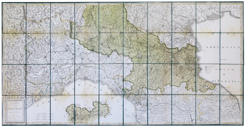
PAGNI (Niccolo) & BARDI (Lorenzo).
Carta del territorio della Repubblica Cisalpina e di parte delli stati limitrofi.
Firenze, Pagni, e Bardi, 1797. En 40 sections montées sur soie verte et pliées, formant une carte de 725 x 1460 mm ; étui de papier avec titre en lettres dorées.
Bookseller reference : LBW-444
|
|
|
PAGÈS, Pierre de.
Voyages autour du monde, et vers les deux poles, par terre et par mer, pendant les années 1767, 1768, 1769, 1770, 1771, 1773, 1774 & 1776.
Paris, Chez Moutard, 1782. 2 Tomes, complet. In-8 - 13 x 20,5 cm. Reliure de l'époque en plein veau marbré, dos lisse orné de caissons dorés aux petits fers, filet doré sur les coupes. 432 pages paginées ; 272 pages paginées. Exemplaire complet de ses 10 hors-texte reliés ensemble à la fin du second volume. Édition originale de cette relation des voyages du capitaine Pagès, illustrée de 7 cartes dépliantes gravées en taille-douce sous la direction de Benard, et de 3 planches dépliantes par le même, dont une montrant le dépècement d'une baleine dessinée par Fossier.
Bookseller reference : 2577

|
|
|
Paher Stanley W. Maps and illustrations by Roy E. Purcell
Las Vegas: As it began - as it grew
Las Vegas: Nevada Publications 1971. 181 pp. b/w illus. throughout. Wrappers handled soiled edgeworn with chipping and one long tape-repaired tear at rear; smudge to fore-edge corners bumped. Interior clean and unmarked. Size: Folio. Paperback. Good/N/A. Nevada Publications Paperback
Bookseller reference : 279380 ISBN : 0913814741 9780913814741
|
|
|
Paher Stanley W./Purcell Roy E. maps/illus
Las Vegas: As It Began as It Grew
Las Vegas: Nevada Paublications 1971. 2nd printing. VG/Good slightly cocked dust jacket chipped/price clipped light musty odor. 181 p. photos maps map on endpapers index 4to; Nevada Paublications hardcover
Bookseller reference : 28552 ISBN : 0913814016 9780913814017
|
|
|
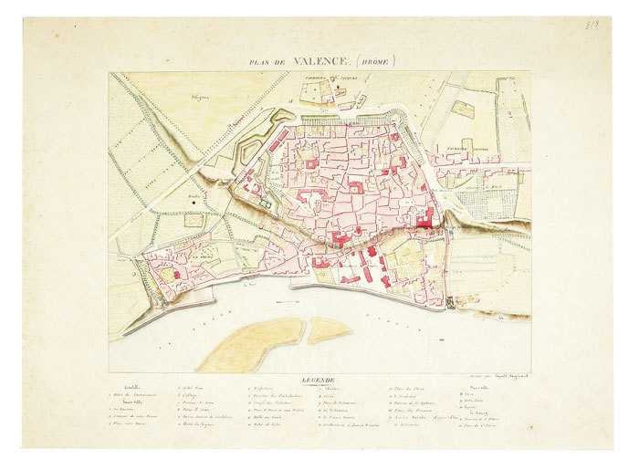
PAIGNARD (Léopold). MANUSCRIT.
Plan de Valence (Drôme).
[circa 1810]. 240 x 335 mm.
Bookseller reference : LBW-736
|
|
|
Painter George D. with illustrations maps drawn by Samuel H. Bryant
Proust; the early years
Boston: Atlantic Monthly Press/Little Brown and Company 1959. Hardcover. xvii 435p. 8p. photos later printing cloth edgeworn dj. Atlantic Monthly Press/Little, Brown and Company hardcover
Bookseller reference : 94939

|
|
|
Painter George D. with illustrations maps drawn by Samuel H. Bryant
Proust; the early years
Boston: Atlantic Monthly Press/Little Brown and Company 1959. Hardcover. xvii 435p. 8p. photos later printing cloth edgeworn dj. Atlantic Monthly Press/Little, Brown and Company hardcover books
Bookseller reference : 94939
|
|
|
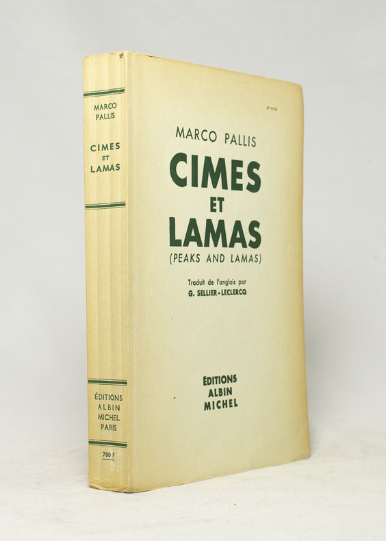
PALLIS Marco; SELLIER-LECLERCQ G. (trad.):
Cîmes et lamas. (Peaks and lamas).
Paris, Editions Albin Michel, 1955. In-8 broché de 334-[2] pages, couverture imprimée.
Bookseller reference : 16668
|
|
|
PALESTINE.
New Map of Palestine showing the proposed U.N. Boundaries of Israel: Jewish and Arab Towns, Villages and Settlements; Plans of Tel-Aviv, Jerusalem and Haifa; Index of Place names. Scale One Inch to Four and a Half Miles. NEAR FINE COPY OF THE FIRST JEWISH CHRONICLE MAP OF PALESTINE
8vo., folding coloured map on paper measuring 40 x 30 inches (approx. 102 x 76 cms) folding in 30 panels to 8.5 x 5.25 inches (approx. 22 x 13 cms); original blue wrappers printed in black, yapped edges, a virtually unopened, unused copy. EXTREMELY SCARCE IN THIS CONDITION.
|
|
|
PALM, Erwin Walter (1910-1988).
Heimkehr ins Exil. Schriften zu Literatur und Kunst. Im Auftrag der Heidelberger Akademie der Wissenschaften. Herausgegeben von Helga von Kügelgen und Arnold Rothe.
Köln & Weimar, Böhlau Verlag, 1992 [Forum Ibero-Americanum]. 4to.; XIV-486 pp. Con 113 ilustraciones fotográficas y reproducciones, en láminas aparte. Cubiertas originales.

|
|
|
Palmer, W. T.
The Handy Guide to the English Lakes
No marks or inscriptions. No creasing to covers or to spine. A very clean very tight copy with foxing to boards, dusty page edges and no bumping to corners. 88pp. Guide to England's Lake District -, covering walking, history, angling, mountaineering, local authorities, places to visit etc. Photographs throughout and cover illustration by W Heaton Cooper. Undated but talks about 1935 in the past. We do not use stock photos, the picture displayed is of the actual book for sale. Every one of our books is in stock in the UK ready for immediate delivery.

|
|
|
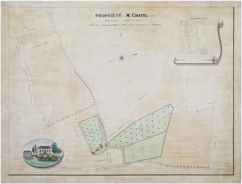
PAMISEUX.
[SEINE-MARITIME] Propriété de M. Chatel Abel, manufacturier à Elbeuf-sur-Seine, située sur la commune de Bosc-le-Hard et par extension sur celle d'Etaimpuis (Seine-Inf.re).
1879. 60 x 80 cm, monté sur une feuille de papier bleu.
Bookseller reference : LBW-7454
|
|
|
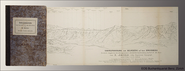
Panorama.- Imfeld, X(aver):
Gebirgspanorama vom Belvedère auf dem Zürichberg. Erweiterte Ausgabe des Zürichbergpanorama's oberhalb der Karolinenburg von Alb(ert) Heim.
Zürich, Caesar Schmidt, o.J. (1877). Gef. Federlithographie (Leporello) in Halbleinenumschlag (8°). Bildformat: 16,8 x 167 cm. Blattformat: 19,1 x 168 cm. (Einbanddeckel stärker berieben und bestossen).
Bookseller reference : 1544AG
|
|
|
Pan American World Airways, Inc.
Pan American World Airways System
Pan American World Airways System : world's most experienced airline ; copyright 1956 by Pan American World Airways, Inc. Cartography by John Philip. Art by Paul John Brown. "All rights reserved by Pan American World Airways, Inc." Litho in U.S.A. 2/64 Revised 2/64.Grande planisfero a proiezione di Mercatore pubblicato dalla Pan Am Airlaines nel 1956.Raffigura tutte le rotte della aereoflotta della Pan Am nel 1956, delineate in rosso sulla mappa.Litografia, in perfetto stato di conservazione. Striking large map of the World, published by Pan American Airlines, as a promotional item.Shows all the routes around the world to which Pan Am flew in 1956, including connecting lines and Pan Am's own lines.Cartography by John Philip. Art by Paul John Brown.Full title:Pan American World Airways System : world's most experienced airline ; copyright 1956 by Pan American World Airways, Inc. Cartography by John Philip. Art by Paul John Brown. "All rights reserved by Pan American World Airways, Inc." Litho in U.S.A. 2/64 Revised 2/64.Full color map 81 1/2x147 1/2. Includes legend. Shows routes of Pan American World Airways System in red lines. Connecting lines, and distances in miles and kilometers are shown. Relief shown pictorially. Includes time zones on lower panel.Litograph, very good condition.

|
|
|
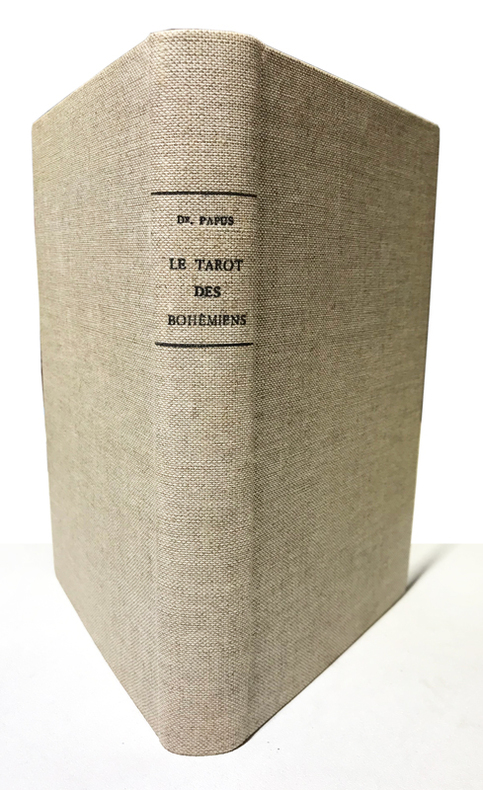
Papus (Dr Gérard Encausse) :
Clef absolue de la Science Occulte. Le Tarot des Bohémiens. Le plus ancien livre du Monde à l'usage exclusif des initiés. Troisième édition.
Paris, Durville, sans date (1911) ; in-8 ; pleine toile écrue (reliure première moitié du XXe) ; 349 pp., (6) pp. de catalogue, premier plat ocre conservé, nombreuses figures. Préface de la 2e édition.
Bookseller reference : 15003
|
|
|
PAPY Louis Photos et cartes hors texte.
Les Landes de Gascogne et la Côte d'argent.
Couverture souple. Broché. 192 pages.
Bookseller reference : 136967
|
|
|
PAPUS Dr. Gérard Encausse
TRAITÉ MÉTHODIQUE DE MAGIE PRATIQUE
Paris Editions Dangles, sans date (vers 1950) 0 in 8 (24x15) 1 fort volume broché, VIII et 639 pages, avec 113 figures dans le texte. Gérard Encausse dit Papus, 1865-1916. Troisième édition. Bel exemplaire ( Photographies sur demande / We can send pictures of this book on simple request )
Bookseller reference : 37851
|
|
|
PAQUAY Jean (Abbé)
Aperçu historique sur la ville de Tongres.
Tongres, Société scientifique et littéraire du Limbourg, 1911. 15 x 23, 81 pp., broché, état moyen (couverture déchirée avec plusieurs manques, cachets du Collège jésuite Saint Stanislas à Mons, quelques pages salies).
Bookseller reference : 23331
|
|
|
PARROT (André)
Babylone et l'Ancien Testament. Richement documenté (planches et cartes, figures).
Ed. Delachaux & Niestlé 1956. Bel exemplaire broché, in-8, 141 pages + planches.
Bookseller reference : AUB-7542
|
|
|
PARIS.
Carte du Département de la Seine exécutée en 1839 au dépot général de la Guerre, sous la Direction du Général de Division Pelet, d'après les levers des officiers du Corps d'Etat Major.
Paris, s.n., 1839. Carte entoilée aquarellée de 115 cm x 87 cm.
Bookseller reference : 5440
|
|
|
PARE Nadine - MILLIARD Jean Bernard
Le Cher Soldat illustré Par Les Cartes Postales ( 1900-1920 )
Bourges Promo Cher 1990 15,5x24 221 pages - album retracant toute la vie militaire dans le cher au début du 20e siècle - trés nombreuses illustrations - trés bon etat
Bookseller reference : 35Cm
|
|
|
PARE Nadine - MILLIARD Jean Bernard
Le Cher Soldat illustré Par Les Cartes Postales ( 1900-1920 )
Bourges Promo Cher 1990 15,5x24 221 pages - album retracant toute la vie militaire dans le cher au début du 20e siècle - trés nombreuses illustrations - trés bon etat
Bookseller reference : 35Cm
|
|
|
PARIS (plan de)
Nouveau plan de Paris, nomenclature des rues du nouveau plan, itinéraire des omnibus et tramways.
Paris, Lainée Éditeur Géographe, 1887, 11,7 X 18,5 cm pour la rel. carto. édit. roug. - 68 X 90 cm pour le plan en coul. dépl.
Bookseller reference : 3725
|
|
|
Paris-Hollywood
Paris-HollywoodSexe-appeal et cinéma Une femme gagnée aux cartes (Nouvelle inédite de Dorian Gray) - Loufoqueries californiennes - L'envers du décor - Madame prêche pour son sein (dialogue sans commentaire) - Paris la nuit - Cavalerie légère - Jeux de dames - On aime pas une femme sandwich - Pour rire à deux - ...
N° 29 - Paraît le 1er et le 15 de chaque mois - Direction, rédaction, publicité : 2, avenue Matignon, Paris VIIIe - Couverture : Jane Russel - 4me de couverture : Barbara Bates - grand in-8 broché - revue illustrée
Bookseller reference : 73789
|
|
|
PARIS.
Plan de Paris Actuel.
Paris, Maison Ligerot et Gaultier, 1881. Plan en couleurs entoilé de 84 cm x 60 cm. Plan replié dans un porte-feuille en percaline rouge d'éditeur, avec son index des rues.
Bookseller reference : 5441
|
|
|
par Mentelle, Historiographe du Comte d'Artois Gravée par P.F. Tardieu
XVIIIe Carte de France. Début des Capétiens. Troisème race et règnes suivants
Gravée par P.F. Tardieu, authentique datée vers 1790, sur papier fort, recto uniquement, pliable, dimensions : 39 cm x 27 cm, parfait état. Dynastie de rois de France, la dynastie des Capétiens est issue du roi Hugues Ier Capet, auquel elle doit son nom. Celui-ci, en mettant en place l’hérédité dynastique, est devenu la souche commune des trois dynasties de souverains – Capétiens, Valois, Bourbons – qui se sont succédé sur le trône de France jusqu'en 1848 (c'est-à-dire pendant près d'un millénaire), et dont les branches collatérales ont régné sur les royaumes de Naples, de Hongrie et d'Espagne. Classeur 3
Bookseller reference : CZC-11677

|
|
|
par Mentelle, Historiographe du Comte d'Artois Gravée par P.F. Tardieu
XVIIIe Carte de France. Début des Capétiens. Troisème race et règnes suivants
Gravée par P.F. Tardieu, authentique datée vers 1790, sur papier fort, recto uniquement, pliable, dimensions : 39 cm x 27 cm, parfait état. Dynastie de rois de France, la dynastie des Capétiens est issue du roi Hugues Ier Capet, auquel elle doit son nom. Celui-ci, en mettant en place l’hérédité dynastique, est devenu la souche commune des trois dynasties de souverains – Capétiens, Valois, Bourbons – qui se sont succédé sur le trône de France jusqu'en 1848 (c'est-à-dire pendant près d'un millénaire), et dont les branches collatérales ont régné sur les royaumes de Naples, de Hongrie et d'Espagne. Classeur 3
Bookseller reference : CZC-11677
|
|
|
par Mentelle, Historiographe du Comte d'Artois Gravée par P.F. Tardieu
XVIIIe Carte de Tardieu. Empire de Charlemagne par Mentelle, Historiographe
Gravée par P.F. Tardieu, authentique datée vers 1790, sur papier fort, recto uniquement, pliable, dimensions : 39 cm x 27 cm, parfait état. L'Empire carolingien est le résultat de l'expansion territoriale du royaume franc sous l'influence de la dynastie carolingienne pendant le haut Moyen Âge. Il s'étend de l'Europe occidentale à l'Europe centrale. Charlemagne était à la tête de près de la moitié de l'Europe et de 10 millions de sujets, de la Mer du Nord à la Méditerranée. Par ses conquêtes, le fondateur de la dynastie carolingienne a doublé l'étendue des territoires soumis aux rois des Francs, et a régné sur un empire de 1,2 million de km2. Classeur 3
Bookseller reference : CZC-11678

|
|
|
par Mentelle, Historiographe du Comte d'Artois Gravée par P.F. Tardieu
XVIIIe Carte de Tardieu. Empire de Charlemagne par Mentelle, Historiographe
Gravée par P.F. Tardieu, authentique datée vers 1790, sur papier fort, recto uniquement, pliable, dimensions : 39 cm x 27 cm, parfait état. L'Empire carolingien est le résultat de l'expansion territoriale du royaume franc sous l'influence de la dynastie carolingienne pendant le haut Moyen Âge. Il s'étend de l'Europe occidentale à l'Europe centrale. Charlemagne était à la tête de près de la moitié de l'Europe et de 10 millions de sujets, de la Mer du Nord à la Méditerranée. Par ses conquêtes, le fondateur de la dynastie carolingienne a doublé l'étendue des territoires soumis aux rois des Francs, et a régné sur un empire de 1,2 million de km2. Classeur 3
Bookseller reference : CZC-11678
|
|
|
par Mentelle, Historiographe du Comte d'Artois Gravée par P.F. Tardieu
XVIIIe Carte de France. temps de Clovis, par Mentelle, Historiographe
Gravée par P.F. Tardieu, authentique datée vers 1790, sur papier fort, recto uniquement, pliable, dimensions : 39 cm x 27 cm, parfait état. Classeur 3
Bookseller reference : CZC-11676

|
|
|
par Mentelle, Historiographe du Comte d'Artois Gravée par P.F. Tardieu
XVIIIe Carte de France. temps de Clovis, par Mentelle, Historiographe
Gravée par P.F. Tardieu, authentique datée vers 1790, sur papier fort, recto uniquement, pliable, dimensions : 39 cm x 27 cm, parfait état. Classeur 3
Bookseller reference : CZC-11676
|
|
|
PARDO DE DONLEBÚN Y BRAQUEHAIS, Narciso.
Cartografía Marítima Africana.
Madrid, Instituto de Estudios Africanos, 1968. 4to. mayor; 18 pp., 1 h., con cinco graficos entre el texto. Cubiertas originales.

|
|
|
PARIS
Plan de Paris par Arrondissement. [Pocket Guide] SPLENDID COPY. SPLENDID COPY
Sm. 8vo., with 22 double-page maps coloured in outline and a large folding coloured map, all on japon, street directory tabbed by initial letter, some very age-browning; original red cloth, upper board blocked and lettered in silver, a remarkably bright, clean copy. Lovely copy of a beautifully constructed, comprehensive and detailed pocket plan. The double-page maps comprise Paris, the Metro, 20 individual arrondissements, three arrondissements with detailed insets, and the Bois de Boulogne. The large coloured map depicts Paris by arrondissement (obverse) and metro lines and autobus routes (reverse). The two parallel tabbing systems (streets & localities, and maps) enable one to pinpoint any given location simply and easily. Very scarce in this condition.
|
|
|
PARIS - PLAN DE TURGOT
Le plan de Louis Bretez dit Plan de Turgot. Planches (39x58 cm) des 20 quartiers de Paris. Le plus beau plan de Paris ? vol d'oiseau. Notice d'Andr? Rossel. Maquette et couverture de F. Doat.
20 planches et 20 feuilles de descriptions et notices. Couverture d?fraichie.
|
|
|
Paris -:
Stadtplan von Paris: "Westliche Hälfte von Paris." "Östliche Hälfte von Paris." Stahlstiche aus Meyers Handatlas, Karte 14 und 15. Von 2 Platten gedruckt und zu einem großen Plan zusammengesetzt.
Format (Bidbereich): 41 x 60,5 cm. Blattgröße: 48 x 69 cm. *"Enthaltend die Quartiere du Roule, des Champs Elysées, de la Place Vendóme, des Tuileries, St. Germain du Luxembourg, de la Sorbonne; des Marches, St. Martin des Champs; St. Avoye, de Popincourt, de`l Hotel du Ville, Jardin du Roi". Am Unterrand: "Profile der merkwürdigsten Gebäude". - Sauber und gut erhalten. Graphiken de
|
|
|
Parish, Steve
A Souvenir of Sydney : New South Wales Australia
No marks or inscriptions. No creasing to covers. A very clean very tight copy with bright unmarked boards, very minor traces of storage and no bumping to corners. 57pp. A mainly illustrated tribute to the beauty and diversity of the Australian city of Sydney.

|
|
|
Parker Robert M. author; Wong Jeanyee maps; Wormell Christopher drawings
BURGUNDY : A COMPREHENSIVE GUIDE TO THE PRODUCES APPELLATIONS AND WINES SIGNED
New York: Simon and Schuster 1990. Hardcover. Octavo; VG/VG-; Hardcover with DJ; DJ spine black with gold print; DJ has slight edgewear but is clean and bright; Boards quarter bound with red cloth to spine and grey paper to boards clean and strong; Text block clean and tight; Signed in ink by the author on front endpaper; 1052 pages illustrated 2-color. 1334823. FP New Rockville Stock. Simon and Schuster hardcover books
Bookseller reference : 1334823 ISBN : 0671633783 9780671633783

|
|
|
Parker, Dave
First Water, Tigers! - A History of the Victoria Fire Department
234 pages including bibliography and index. "Tells the colourful story of the Victoria Fire Department through a well-researched absorbing text and in hundreds of eloquent photographs. Included also are maps, appendices of the department's apparatus over the years, and sections of aural history dating back to 1912, as well as numerous anecdotes. Many original archival sources and the official records of the Victoria Fire Department were used in research." - from dust jacket. Black and white illustrations throughout, plus several in colour. Book clean, bright and unmarked but for date written atop decorated front endpaper. Average wear but no tears to dust jacket. Very nice copy. Book
|
|
|
Parkman Francis; Maps Illustrator
Half-Century of Conflict in Two Volumes France and England in North America Part VI
Little Brown and Company 1892. Hardcover. Good/No Jacket. L 8vo 7.75 - 9.75'' tall. "A Series of Historical Narratives. Ex-Library Usual Markings. 2 volumes complete. Light general wear. Volume 2 spine top cloth frayed. 333 395 pages. . ISBN: B0046167ME. Catalogs: History:. Little, Brown and Company hardcover
Bookseller reference : 83511
|
|
|
Parkman Frances Edgar Pelham Ed. Illustrated by Illus. reproduced from paintings maps etc
The Romance of Canadian History. Edited From the Writings of Francis Parkman
Toronto: George N. Morang & Company Limited 1902 Very Good/No dust jacket as Issued. Unknown Printing. Decorated Binding. Octavo. Decorated green cloth t. e. g gilt titles. 416 pp. index five maps: 3 full pp. 2 in-text. Very mild waterstains & scuffs to rear board 1/2" crack to top of fr. inner hinge minimal wear to extremities a bit bowed. A better than avg. copy. Based upon Parkman's massive work "France and England in North America" as well "The Conspiracy of Pontiac" the editor's aim is "to present these writings in a succinct and continuous narrative of early Canadian history". Many full page & vignette illus. A neat abridgement attractively presented and well illustrated. Ideal for youthful readers or those disinclined to Parkman's multi-volume magnum opus. A scarce piece of Parkmaniana. Toronto: George N. Morang & Company, Limited, 1902 hardcover
Bookseller reference : 000191
|
|
|
Parks, William A.
Report on the Building and Ornamental Stones of Canada - Volume III: Province of Quebec
304 pages. Index. Colour and black and white photographic plates. Maps. Foldouts. Chapters include: Limestones; Sandstones; Granites and Gneisses; The So-Called Black Granites and Related Rocks; Marbles; Serpenties and Serpentine Marbles; Slates; Glacial Drift; Rarer Decorative Materials; plus appendices. Average wear and soiling externally. Binding intact. Tears to top of spine. Solid copy of this authoritative reference. Book

|
|
|
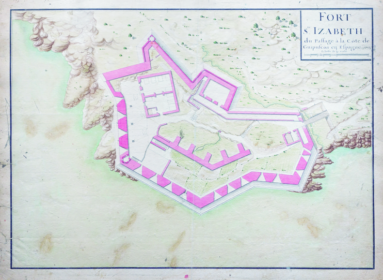
PASAIA. MANUSCRIT.
Fort S.te Izabeth du Passage à la côte de Guipuscöa en Espagne.
[circa 1750]. 362 x 506 mm.
Bookseller reference : LBW-4129
|
|
|
PASSELAIGUE LOUIS
HISTOIRE DES RUES DE CLERMONT ET MONTFERRAND
CLERMONT- FERRAND DE BOREE 1997 1 volume in-4 de 207 pages , dans sa couverture cartonnée éditeur en couleurs , très nombreuses reproductions de photos , gravures et cartes postales anciennes , envoi autographe , un léger écrasement à l'angle inférieur du mors du deuxième plat , bon exemplaire . Bon Couverture rigide
Bookseller reference : 004587
|
|
|
Passchier Anne
La France de A à Z
TIGRE ET CIE 2021 24 pages 20 7x20 7x1 9cm. 2021. board_book. 24 pages.
Bookseller reference : 500115097

|
|
|
Passchier Anne
La France de A à Z
TIGRE ET CIE 2021 24 pages 20 7x20 7x1 9cm. 2021. board_book. 24 pages.
Bookseller reference : 500115200

|
|
|
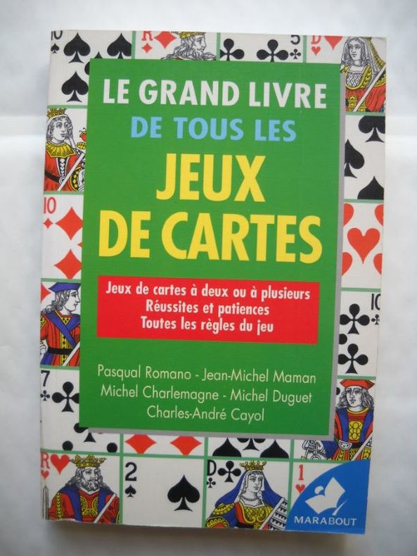
PASQUAL ROMANO - JEAN MICHEL MAMAN - MICHEL CHARLEMAGNE - MICHEL DUGUET - CHARLES ANDRE CAYOL -
LE GRAND LIVRE DE TOUS LES JEUX DE CARTES Jeux de cartes à deux ou a plusieurs Réussites et patiences Toutes les règles du jeu
Broché - 13 x 19,5 - 479 pp - année 1999 - Editions Marabout - Illustrations
Bookseller reference : 18648
|
|
|
PASTOUREAU Mireille , HOMET Jean-Marie , PICHARD Georges
Rivages & Terres De Provence : Cartographie d'une Province
Avignon A. Barthélemy 1991 Grand In Quarto Depuis la Gaule Romaine , les cartes n'ont cessé de préciser l'image de la Provence et des régions avoisinantes . Voici l'album des anciennes cartes et des premiers plans . Nombreuses illustrations de cartes en couleurs et noir et blanc . Très beau cadeau à faire . Cartes et plans . Voyages . - 176 p. , 1 kg 850 gr.
Bookseller reference : 022234

|
|
|
PASTOUREAU Mireille
Voies Océanes de l' Ancien au Nouveau Monde.
P, Editions Hervas,1990, in4° reliure éditeur; 185pp, 164 illustrations. Une histoire de la cartographie des deux Indes par la Spécialiste du sujet. Indispensable et, .passionnant .!
Bookseller reference : M3569
|
|
|
PASUMOT François:
Voyages physiques dans les Pyrénées en 1788 et 1789. Histoire naturelle d'une partie de ces montagnes, particulièrement des environs de Baège, Bagnères, Cautères et Garvanie.
Paris, Le Clere, 1797. In-8 de [4]-XXIV-420-[4] p., plein veau marbré, dos lisse orné de filets et fleurons dorés, étiquette de titre rouge.
Bookseller reference : 6471

|
|
 Receive by email
 Download as PDF document
 RSS feed


