|
Dr. Jan-M. Goris,
Kaartboek van de Abdij van Tongerlo 1655-1794 (Cartografische en iconografische bronnen voor de geschiedenis van het landschap in Belgie, V)
, rijksarchief, 2001 Gebonden in een vollinnen band.groot formaat (33,5 x 24 cm). in prima staat.
Bookseller reference : 41943
|
|
|
Drago Harry Sinclair; Maps b&w Photographs and
Great American Cattle Trails The Story of the Old Cow Paths of the East and the Longhorn Highways of the Plains
Bramhall House. Very Good in Very Good Dust Jacket. 1965. 1st Edition. Hardcover. DJ in new mylar. ; 8vo 8" - 9" tall; 274 pages; 27567 . Bramhall House hardcover
Bookseller reference : 27567

|
|
|
Drake St. Clair; Cayton Horace R.; 39 b/w Figures including maps; 33 Tables Illustrator
Black Metropolis: A Study of Negro Life in a Northern City A Harbinger Book; H-078/079 2 Volume Set
Harcourt Brace & World 1970-01-01. Paperback. Good. Good 2 VOLUME SET OF paperbacks. Pages are clean and unmarked. Covers show light edge wear. Creases on spines. Previous owner's name on inside front covers.; 100% Satisfaction Guaranteed! Ships same or next business day! Harcourt, Brace & World paperback
Bookseller reference : 1212070022
|
|
|
DRAWING TROMPE L'OEIL MAPS.
Trompe l'oeil drawing of country maps on a decorated background titled: Ciels Saint-Vincent.France August 1888. Brown and black ink watercolour chalk and gold paint on paper mounted on several laminated sheets of paper 69.5 x 52.5 cm.
Charming trompe l'oeil of maps of European countries on a decorated background somewhat reminiscent of a church ceiling. It contains a French inscription "to my beloved parents" which together with some inconsistencies in the use of perspective suggest a young French artist. The maps show some interesting departures from reality: in the Netherlands parts of the province of Gelderland are shifted 50 kilometres to the north replacing Zwolle with Arnhem and Sweden lacks Stockholm but includes Copenhagen in place of Malmö. However the most humorous is in the map of Germany which lacks its western neighbours - the Netherlands Belgium Luxemburg and France - giving it an extensive North Sea coast. The gothic lettering is inconsistent in style with the artist apparently improvising an alphabet for each inscription in the process forgetting Denmark.Somewhat soiled and browned at the edges with several white spots due to overpainting; the sheets are coming loose from one another. unknown
Bookseller reference : J4KDIGIVEPWU

|
|
|
Drew David Illustrations by Dorothy Dunphy & Donna Rawlins; maps by Neil Kennan
Somewhere in the Universe
Crystal Lake IL: Rigby Education nd 1988. Paperback rustica broche. Covers lightly rubbed else clean tight copy: VG. 12mo. Illustrated in color by Dorothy Dunphy and Donna Rawlins; maps by Neil Kennan. Rigby Education paperback
Bookseller reference : 33042412
|
|
|
Drews, John
The Lakeland One Hundred
Name/date to front end paper. No other marks or inscriptions. A very clean very tight copy with bright unmarked boards and no bumping to corners. Dust jacket not price clipped or marked or torn with minor creasing to edges and a little indenting. 189pp. Circular walks to the 100 highest peaks in England's Lake District. Well illustrated.

|
|
|
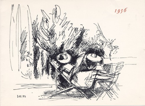
Dries, Jean
Jean Dries : carte de voeux pour 1956 et gravure originale
1956 Carte de voeux de Jean et Henriette Dries pour l'année 1956. 14,5 x 20 cm, 2ff., portant une gravure en noir en page 3, signée dans la planche et les voeux imprimés en regard.
Bookseller reference : 1479
|
|
|
Driver, S. R
Notes on the Hebrew Text and the Topography of the Books of Samuel. With an introduction on Hebrew palaeography and the ancient versions, and facsimiles of inscriptions and maps. [By the Rev. S. R. Driver]. 2. edition, revised and enlarged.
Oxford: The Clarendon Press 1913. XCVI, 390 Seiten. Gr. 8° (22,5-25 cm). Orig.-Leinenband. [Hardcover / fest gebunden].
Bookseller reference : 154154

|
|
|
DROUOT Lucien
L'AUVERGNE D'AUTREFOIS
1980 br. gd. in-8, pl. ill., envoi, nombr. repro. de cartes postales anciennes commentées, sans pagination, 144 p., 1980 horvath éd.,
Bookseller reference : 1180
|
|
|
DROGUET, Alain Droguet, directeur des Archives départementales des Côtes-d'Armor ( actes recueillis par), cartes ; excellent état.
Les Bleus de Bretagne de la Révolution à nos jours - (Actes Du Colloque De Saint-Brieuc-Ploufragan, 3-5 Octobre 1990)
Fédération des Côtes-d'Armor - 1991 - In-8, 16 x 24 cm - Broché - Couverture illustrée - Cartes et illustrations en noir et blanc - 447 pages - très frais
Bookseller reference : 26536
|
|
|
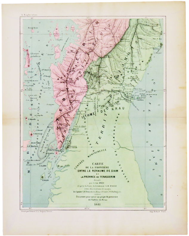
DRU (Léon).
[THAÏLANDE/BIRMANIE] Carte de la frontière entre le royaume de Siam et la province de Tenasserim.
[1882]. 250 x 189 mm.
Bookseller reference : LBW-5008
|
|
|
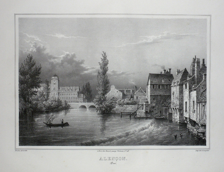
DRULEN;
ALENCON (Orne).
Paris Benard circa 1850 225 x 293 mm.
Bookseller reference : LBW03d73
|
|
|
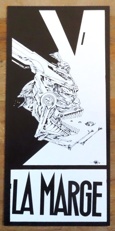
Druillet Philippe:
Carton d'invitation, Galerie La Marge.
Lausanne, La Marge, 1983. Carton d'invitation imprimé recto-verso, au format 10 x 21 cm.
Bookseller reference : 12500
|
|
|
Druillet Philippe:
Le derviche.
P.M.J éditions. Carte postale, à l'état de neuf.
Bookseller reference : 969
|
|
|
Drysdale, Andrew (editor)
The 'Argus' Book of Cape Town
Inscription on half-title page. No other marks. Light creasing to corners, none to spine. A very clean very tight copy with bright unmarked boards and no bumping to corners. 112pp. Guide to Cape Town just as the apartheid era was ending.

|
|
|
dtg MAPS
MAPS Flathead Valley Detail Map Pages and Street Index 5th Edition
dtG MAPS 2003-01-01. Spiral-bound. Fair. B004MON91C 6th edition2005 water damage. still readable copy dtG MAPS unknown
Bookseller reference : 20-02-19-GOOD-28021-RW
|
|
|
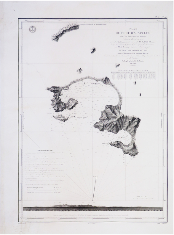
DU PETIT-THOUARS (Louis-Marie Aubert).
[ACAPULCO/MEXIQUE] Plan du port d'Acapulco à la côte sud-ouest du Mexique.
[Paris], Dépôt-Général de la Marine, 1845. 590 x 426 mm.
Bookseller reference : LBW-7720
|
|
|
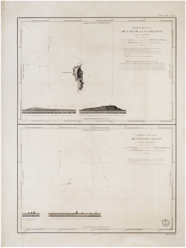
DU PETIT-THOUARS (Louis-Marie Aubert).
[BASSE-CALIFORNIE/MEXIQUE] Croquis de plan de l'île de la Guadeloupe (Basse Californie) - Croquis de plan des Roches Alijos (Basse Californie).
[Paris, 1845]. 592 x 426 mm.
Bookseller reference : LBW-7585
|
|
|
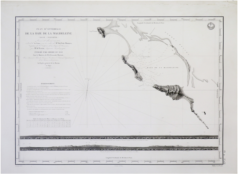
DU PETIT-THOUARS (Louis-Marie Aubert).
[BASSE-CALIFORNIE du SUD/MEXIQUE] Plan d'atterrage de la Baie de la Magdeleine (Basse Californie).
[Paris], Dépôt-Général de la Marine, 1845. 427 x 586 mm.
Bookseller reference : LBW-7683
|
|
|
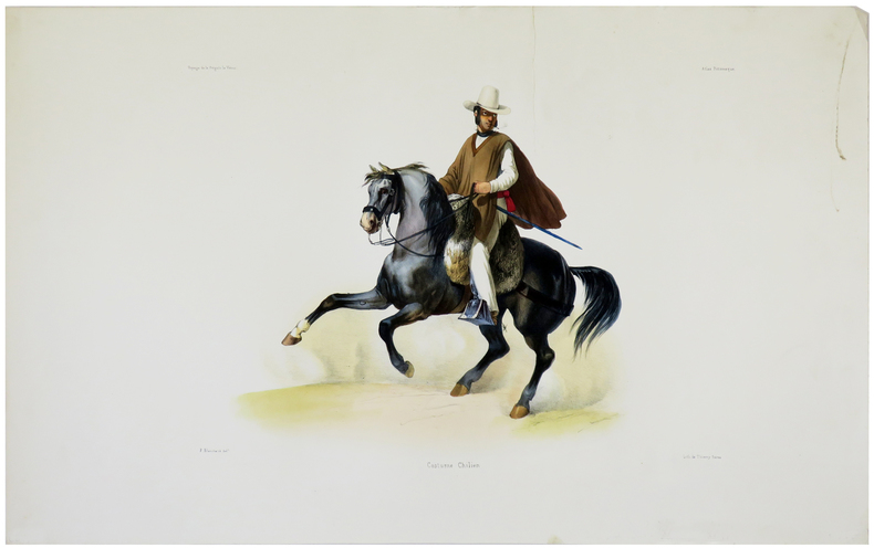
DU PETIT-THOUARS (Louis-Marie Aubert).
[CHILI] Costume chilien.
[Paris, 1841]. 253 x 342 mm.
Bookseller reference : LBW-5494
|
|
|
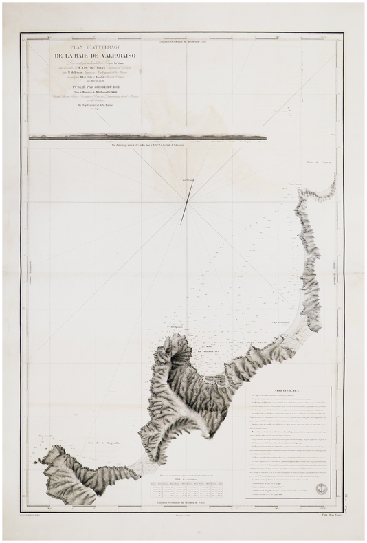
DU PETIT-THOUARS (Louis-Marie Aubert).
[CHILI] Plan d'atterrage de la baie de Valparaiso.
[Paris, 1845]. 888 x 598 mm.
Bookseller reference : LBW-7542
|
|
|
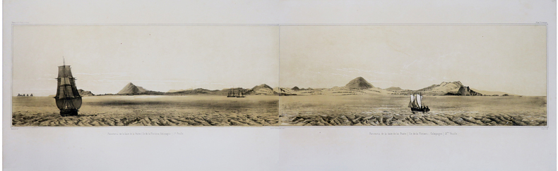
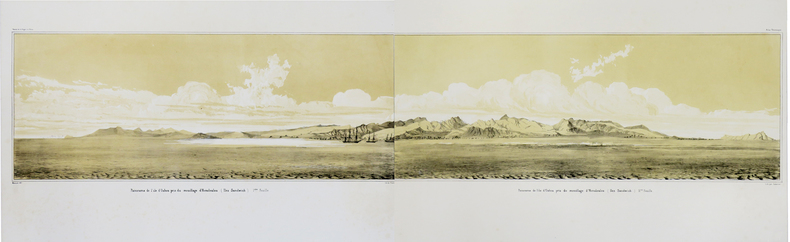
DU PETIT-THOUARS (Louis-Marie Aubert).
[GALAPAGOS] Panorama de la baie de la Poste (Ile de la Floriana, Galapagos).
[Paris, 1841]. En deux feuilles non jointes pouvant former un panorama d'environ 211 mm x 1,02 m.
Bookseller reference : LBW-1781
|
|
|
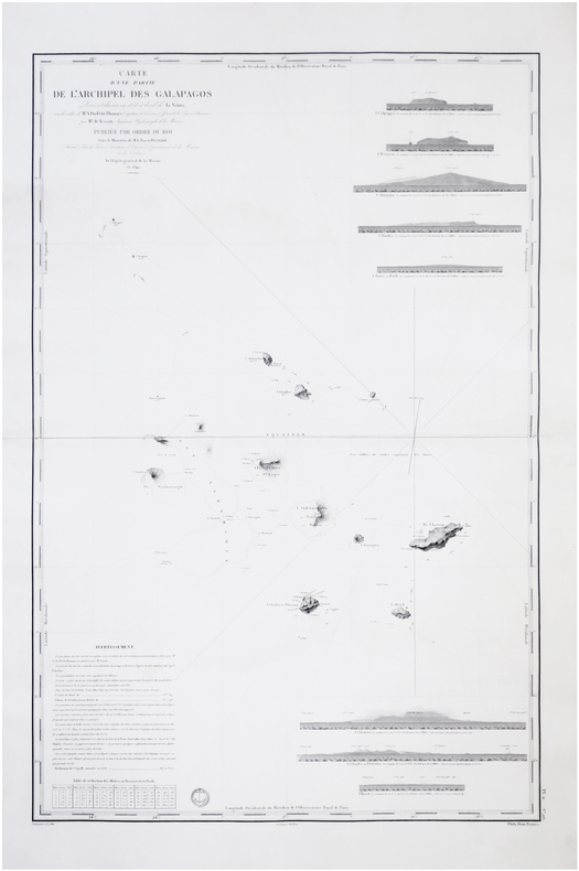
DU PETIT-THOUARS (Louis-Marie Aubert).
[GALÁPAGOS] Carte d'une partie de l'archipel des Galapagos.
[Paris], Dépôt-Général de la Marine, 1842 [1845]. 880 x 590 mm.
Bookseller reference : LBW-7716
|
|
|
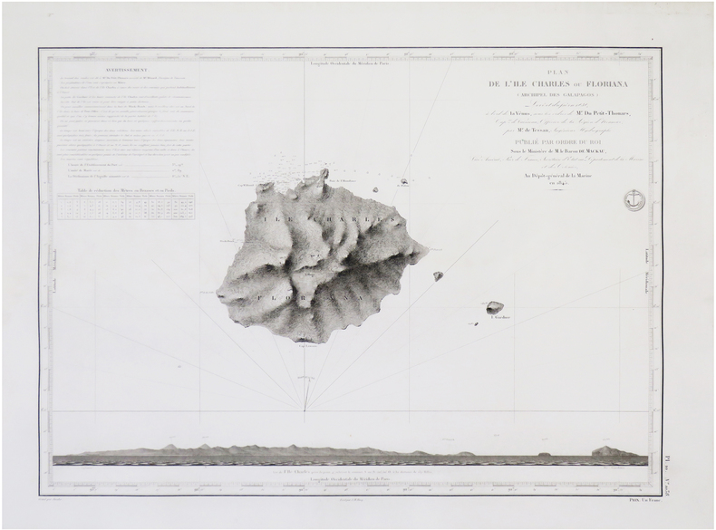
DU PETIT-THOUARS (Louis-Marie Aubert).
[GALÁPAGOS] Plan de l'île Charles ou Floriana (archipel des Galapagos).
[Paris], Dépôt-Général de la Marine, 1845. 425 x 585 mm.
Bookseller reference : LBW-7718
|
|
|
DU PETIT-THOUARS (Louis-Marie Aubert).
[HAWAII] Panorama de l'île d'Oahou pris du mouillage d'Honoloulou (Iles Sandwich).
[Paris, 1841]. En deux feuilles non jointes pouvant former un panorama d'environ 217 mm x 1,02 m.
Bookseller reference : LBW-1782
|
|
|
DU PETIT-THOUARS (Louis-Marie Aubert).
[KAMTCHATKA] Plan de la Baie d'Avatscha au Kamtschatka.
[Paris], Dépôt-Général de la Marine, 1844 [1845]. 600 x 423 mm.
Bookseller reference : LBW-7689

|
|
|
DU PETIT-THOUARS (Louis-Marie Aubert).
[MEXIQUE] Panorama, pris du mouillage de San Blas (côte occidentale du Mexique).
[Paris, 1841]. En quatre feuilles non jointes pouvant former un panorama d'environ 210 mm x 2,04 m.
Bookseller reference : LBW-1702

|
|
|
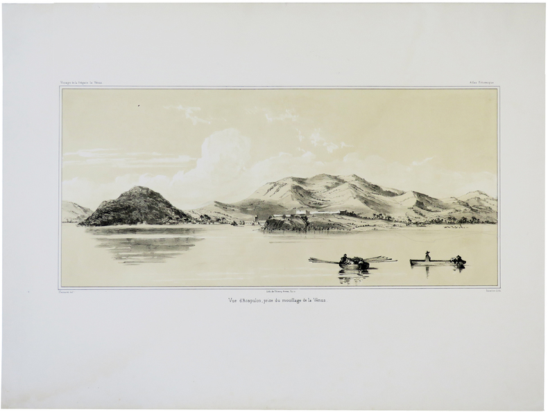
DU PETIT-THOUARS (Louis-Marie Aubert).
[MEXIQUE] Vue d'Acapulco, prise du mouillage de la Vénus.
[Paris, 1841]. 193 x 384 mm.
Bookseller reference : LBW-5674
|
|
|
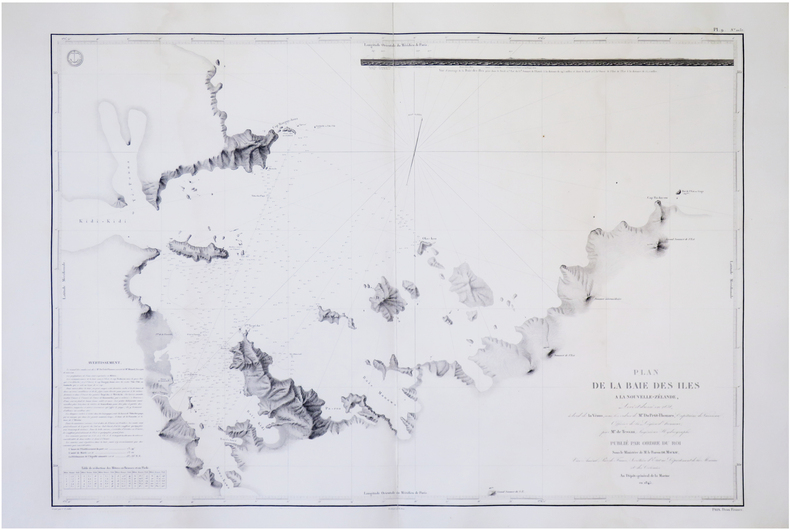
DU PETIT-THOUARS (Louis-Marie Aubert).
[NOUVELLE-ZÉLANDE] Plan de la Baie des Îles à la Nouvelle-Zélande.
[Paris], Dépôt-Général de la Marine, 1845. 605 x 861 mm.
Bookseller reference : LBW-7719
|
|
|
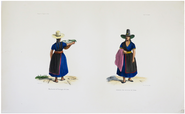
DU PETIT-THOUARS (Louis-Marie Aubert).
[PÉROU] Marchande de fromages de Lima - Indienne des environs de Lima.
[Paris, 1841]. 225 x 332 mm.
Bookseller reference : LBW-5493
|
|
|
DU PETIT-THOUARS (Louis-Marie Aubert).
[PÉROU] Costumes de Lima (Pérou).
[Paris, 1841]. 227 x 250 mm.
Bookseller reference : LBW-5492

|
|
|
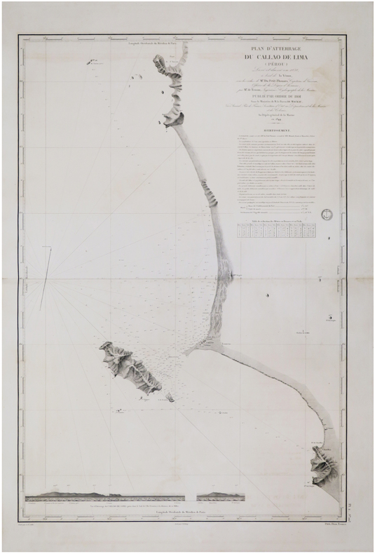
DU PETIT-THOUARS (Louis-Marie Aubert).
[PÉROU] Plan d'atterrage du Callao de Lima (Pérou).
[Paris, 1845]. 880 x 594 mm.
Bookseller reference : LBW-7547
|
|
|
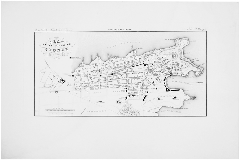
DU PETIT-THOUARS (Louis-Marie Aubert).
[SYDNEY] Plan de la ville de Sydney 1838.
[Paris, 1841]. 196 x 380 mm.
Bookseller reference : LBW-5872
|
|
|
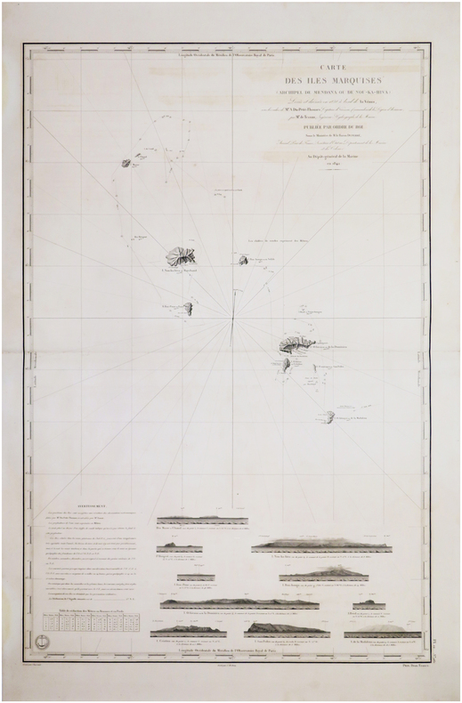
DU PETIT-THOUARS (Louis-Marie Aubert).
[ÎLES MARQUISES/POLYNÉSIE FRANCAISE] Carte des îles Marquises (archipel de Mendana ou de Nou-Ka-Hiva).
[Paris], Dépôt-Général de la Marine, 1842 [1845. 882 x 590 mm.
Bookseller reference : LBW-7576
|
|
|
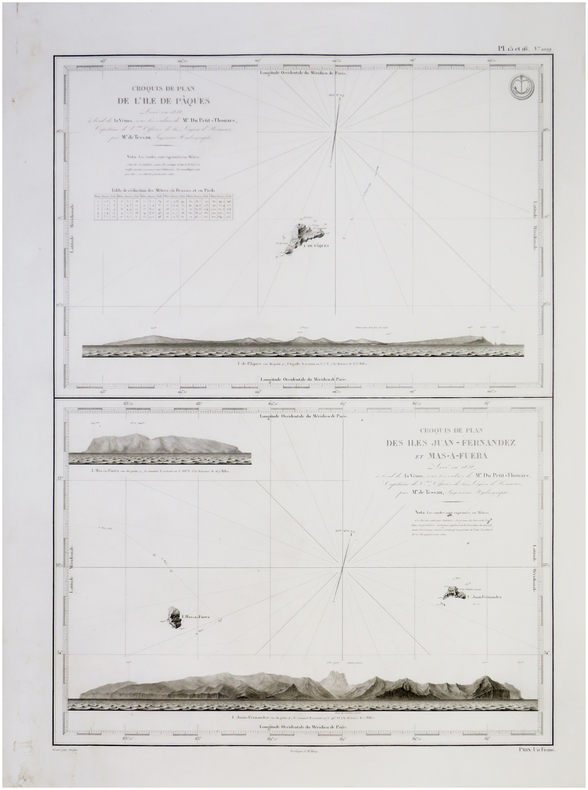
DU PETIT-THOUARS (Louis-Marie Aubert).
[ÎLES de PÂQUES & JUAN FERNANDEZ/CHILI] Croquis de plan de l'île de Pâques - Croquis de plan des îles Juan Fernandez et Mas-a-Fuera.
[Paris, Dépôt-Général de la Marine], 1845. 600 x 420 mm.
Bookseller reference : LBW-7696
|
|
|
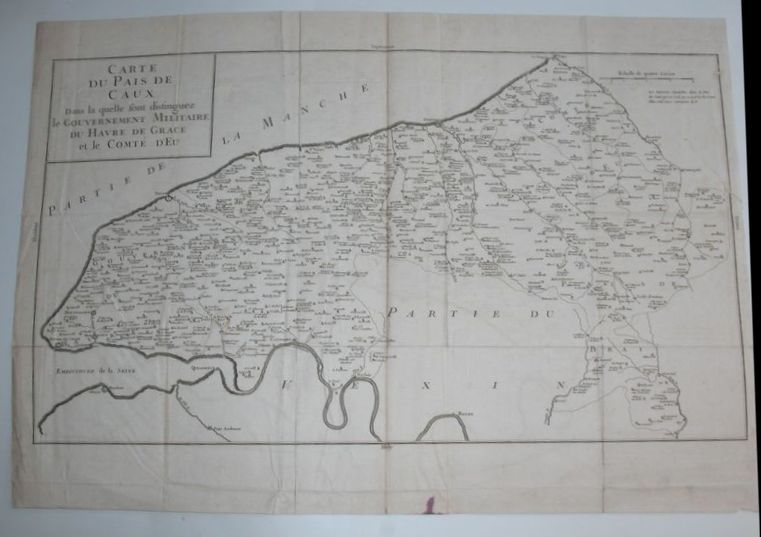
DU PLESSIS (Dom Toussaints).
Carte du Pays de Caux dans la quelle sont distinguez le Gouvernement Militaire du Havre de Grace et le Comté d'Eu.
Paris, Giffard, 1740. Carte gravée en noir, 64 x 45 cm, trace de pliures.
Bookseller reference : 16272
|
|
|
DU BUS (Charles)
Les Cartes et plans à l'exposition révolutionnaire de la Bibliothèque Nationale.. Extrait de "La Révolution française" (n°37, 1928)
Paris, Imprimerie de la Cour d'Appel, 1928 gr. in-8, 30 pp., broché.
Bookseller reference : 131055
|
|
|
Du PINET Antoine (1510 - 1584 circa)
Description de la Cité de Romme
Rarissima pianta prospettica della città, sconosciuta ai principali repertori sulle piante di Roma e pubblicata per la prima volta in Marigliani (2007).Si tratta di una copia della pianta del Munster senza alcun aggiornamento e ritrae la città come si presentava alla fine del '400 attingendo al medesimo prototipo comunemente indicato nel panorama di Mantova a sua volta ripreso da un presunto ma tuttora sconosciuto panorama inciso nella bottega di Francesco Rosselli verso il 1485. Tavola tratta dal rarissimo "Plantz, pourtraitz et descriptions de plusieurs villes et forteresses, tant de l'Europe, Asie, & Afrique, que des Indes, & terres neuves: Leurs fondations, antiquitez, & manieres de vivre: Avec plusieurs cartes generales & particulieres, servans à la Cosmographie, iointes à leurs declarations: deux tables fort amples, l'une des chapitres, & l'autre des matieres contenues en ce present livre. Le tout mis par ordre, region par region, par Antoine du Pinets" stampato a Lione dall’editore Jean d’Ogerolles. L'opera, che contiene 55 tavole silografiche - molte dele quali derivanti da Muenster - include il mondo cordiforme sul modello di Appiano, le mappe di europa e Germania e 18 vedute a doppia pagina delle primcipali città del tempo.La veduta di Roma deriva da quella pubblicata sempre a Lione nel 1552 da Guillaume Guéroult nel "Premier livre des figures et portraitz des villes", edita da Balthazar Arnouellet, da cui d’Ogerolles acquisì parte del fondo tipografico. Pertanto possiamo affermare che questa matrice in legno sia la stessa stampata alcuni anni prima, alla quale furono apportate delle correzioni nella cornice e nel titolo. Xilografia, in perfetto stato di conservazione. Rarissima. A very rare map of Rome, unknown by mostly of the repertoiries. The view depicts the city as it was at the end of the 15th century, drawing on the same prototype commonly indicated in the panorama of Mantua in turn taken from a still unknown panorama engraved in the workshop of Francesco Rosselli around 1485.Work taken from the very rare "Plantz, pourtraitz et descriptions de plusieurs villes et forteresses, tant de l'Europe, Asie, & Afrique, que des Indes, & terres neuves: Leurs fondations, antiquitez, & manieres de vivre: Avec plusieurs cartes generales & particulieres, servans à la Cosmographie, iointes à leurs declarations: deux tables fort amples, l'une des chapitres, & l'autre des matieres contenues en ce present livre. Le tout mis par ordre, region par region, par Antoine du Pinets" printed in Lyon by Jean d’Ogerolles. The work include 55 woodcuts, many after Munster, comprising 3 double-page maps (cordiform world after Apianus, Europe and Germany), 7 half-page maps, 18 double-page views (including Lyon, Bordeaux, Geneva, Frankfurt, Florence, Venice, Rome, Constantinople, Jerusalem, Cusco and others), and 27 illustrations (including Mexico city).The view is inspired to Guillame Guéroult’s "Premier livre des figures et portraitz des villes", published in 1552 by Balthazar Arnouellet. From him, d’Ogerolles bought many plates, therefore we can state that this block had been already used many years before and has then undergone some changes before being reprinted. Woodcut, in excellent condition. Valerio pp. 33/34; C. Marigliani, "Le Piante di Roma delle collezioni private", tav. 18

|
|
|
Du Val P.
Coste de Guayane autrement France �quinoctiale en la terre-ferme d'Am�rique suivant les derni�res relations
Paris: Chez l'auteur 1664. Unbound map. Good/No Jacket. Map 27 x 34 cm. Shows the coastal area from the Orinoco to the Amazon with an inset map of Ile de Cayenne. Legendary Lac Parime shown in southern area. Printed in black and hand colored. Creased along middle vertical fold otherwise unworn and unmarked Chez l'auteur unknown
Bookseller reference : 899999

|
|
|
DUBOIS (M.) - SIEURIN (E.)
Cartes d'étude pour servir à l'Enseignement de la Géographie. Géographie générale, Océanie, Afrique, Amérique. 40 cartes et 210 cartons.
Paris, Masson, 1903. In-8 (290x230mm) relié en cartonnage d'éditeur, np. Très bon état intérieur, extérieur présentant quelques salissures.
Bookseller reference : 21570
|
|
|
Dubourg André
Collectionner, éditer des cartes postales
Encyclopédie des connaissances pratiques. 1987. In-8. Broché. Etat d'usage, Couv. convenable, Dos frotté, Intérieur acceptable. 67 pages - nombreuses photos et illustrations en noir et blanc dans et hors texte et planche dépliante en fin d'ouvrage.. . . . Classification Dewey : 741.68-Illustrations des cartes postales
Bookseller reference : R300302647

|
|
|
DUBOIS, Georges - DUBOIS, Camille
La géologie de l'Alsace. Aperçu général et excursions géologiques.
Editions Université de Strasbourg, Mémoire n°13 du service de la carte géologique d'Alsace et de Lorraine, Publié avec le concours du centre national de la recherche scientifique - 1955 - In-4, broché - 312 pages - Figures hors-texte en N&B
Bookseller reference : 122331

|
|
|
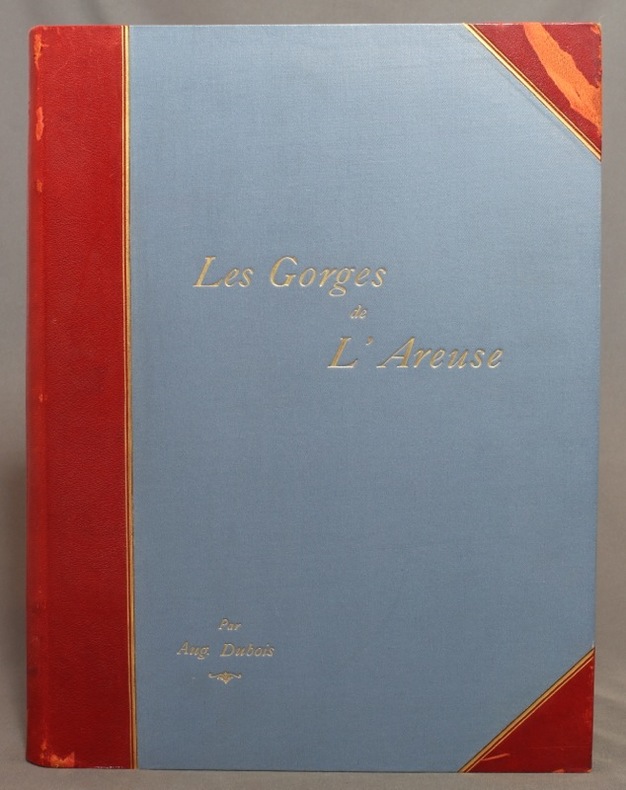
DUBOIS Auguste:
Les gorges de l’Areuse et le Creux du Van.
Neuchâtel, Attinger Frères, 1902. In-4 de [10]-227 pages, demi-maroquin rouge à coins, dos lisse (muet), titre doré au premier plat, doubles filets dorés sur les deux plat, couverture conservée.
Bookseller reference : 1195
|
|
|
DUBOIS Auguste:
Les gorges de l’Areuse et le Creux du Van.
Neuchâtel, Attinger Frères, 1902. In-4 de [8]-227 pages, demi-maroquin bordeaux, plats de percaline rouge, tranches marbrées, dos lisse avec titre doré et filets dorés et à froid.
Bookseller reference : 14046

|
|
|
Ducout, Fran oise
Cartes Postales de Chats
, Pierre Horay, 1984 Hardcover, +-100 pages, Texte en Francais, 320 x 240 mm, coin l g rement d chir sinon bon tat, illustrations en couleur / n/b. ISBN 9782705801403.
Bookseller reference : 60712
|
|
|
DUCHEMIN DESCEPEAUX J.
Lettres sur l’origine de la chouannerie et sur les chouans du Bas-Maine
dédiées au Roi Tome premier seul. In 8 demi-cuir glacé, vert, titre, tomaison, fers, filets, roulette, palmette dorés. Faux-titre, titre, V, 444 pages, imprimé par autorisation du Roi à l’imprimerie royale 1825. Edition originale, très bon état
Bookseller reference : 8764

|
|
|
Ducout, Françoise
Cartes Postales de Chats
Hardcover, +-100 pages, Texte en Francais, 320 x 240 mm, coin légèrement déchiré sinon bon état, illustrations en couleur / n/b. ISBN 9782705801403.

|
|
|
Dudal R.,Osmond D. A.,Tavernier R.
Carte des sols de l'Europe, 1 / 2.500.000 (2 volumes)
Organisation des Nations Unies pour l'Alimentation et l'Agriculture Dos carré collé 1967 Deux volumes in-4 (23,5 x 29,5 cm), dont un volume de notice explicative dos carré collé (126 pages) et une chemise contenant les cartes en couleurs ; manque au dos en tête du livret de notice, quelques marques d'usage et rousseurs éparses, par ailleurs assez bon état. Livraison a domicile (La Poste) ou en Mondial Relay sur simple demande.
Bookseller reference : xa79
|
|
|
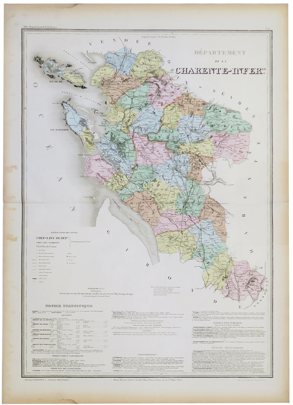
DUFOUR (Auguste-Henri).
[CHARENTE-MARITIME] Département de la Charente Infér.re.
Paris, Maison Bouasse-Lebel et ancienne Maison Basset réunies, [circa 1860]. 760 x 533 mm.
Bookseller reference : LBW-5327
|
|
|
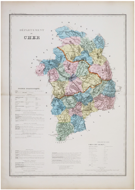
DUFOUR (Auguste-Henri).
[CHER] Département du Cher.
Paris, Maison Bouasse-Lebel et ancienne Maison Basset réunies, [circa 1860]. 753 x 529 mm.
Bookseller reference : LBW-5886
|
|
 Receive by email
 Download as PDF document
 RSS feed


