|
Hema Maps Pty LTD
Western Australia South West NP r hema
Hema Maps Pty LTD. Map. New. Hema Maps Pty LTD unknown
Bookseller reference : 2-1865006718 ISBN : 1865006718 9781865006710
|
|
|
Hema Maps Pty LTD
Western Australia South West NP r hema
Hema Maps Pty LTD. Map. New. Hema Maps Pty LTD unknown
Bookseller reference : __1865006718 ISBN : 1865006718 9781865006710
|
|
|
Hema Maps Pty LTD
Western Australia Mid West r/v r hema
Hema Maps Pty LTD. Map. New. Hema Maps Pty LTD unknown
Bookseller reference : __1865006823 ISBN : 1865006823 9781865006826
|
|
|
Hema Maps PtyLtd y. Lt
Western Australia South West NP: HEMA.2.030
2013-10-18. New. Ships with Tracking Number! INTERNATIONAL WORLDWIDE Shipping available. May be re-issue. Buy with confidence excellent customer service! unknown
Bookseller reference : 1865006718n ISBN : 1865006718 9781865006710

|
|
|
Hema Maps PtyLtd y. Lt
Western Australia Handy Map Hema 2014
Hema Maps Pty.Ltd. MAP. 1865009881 Brand new book.Buy with confidence. Money Back Guarantee.Expedite Shipping Available. International shipment available. . New. Hema Maps Pty.Ltd unknown
Bookseller reference : AABEY01114 ISBN : 1865009881 9781865009889

|
|
|
Hema Maps PtyLtd y. Lt
Western Australia Handy Map Hema 2014
Hema Maps Pty.Ltd. MAP. 1865009881 Brand new book.Buy with confidence. Money Back Guarantee.Expedite Shipping Available. International shipment available. . New. Hema Maps Pty.Ltd unknown
Bookseller reference : A2BEY01113 ISBN : 1865009881 9781865009889
|
|
|
Hema Maps PtyLtd y. Lt
Western Australia Handy Map Hema 2014
2014-07-01. New. Ships with Tracking Number! INTERNATIONAL WORLDWIDE Shipping available. May be re-issue. Buy with confidence excellent customer service! unknown
Bookseller reference : 1865009881n ISBN : 1865009881 9781865009889

|
|
|
Hema Maps PtyLtd y. Lt
Western Australia State 2014: HEMA
2014-05-07. New. Ships with Tracking Number! INTERNATIONAL WORLDWIDE Shipping available. May be re-issue. Buy with confidence excellent customer service! unknown
Bookseller reference : 1865008753n ISBN : 1865008753 9781865008752

|
|
|
Hema Maps PtyLtd y. Lt
Western Australia Handy Map Hema 2014
2014-07-01. Good. Ships with Tracking Number! INTERNATIONAL WORLDWIDE Shipping available. May not contain Access Codes or Supplements. May be re-issue. May be ex-library. Shipping & Handling by region. Buy with confidence excellent customer service! unknown
Bookseller reference : 1865009881 ISBN : 1865009881 9781865009889

|
|
|
Hema Maps PtyLtd y. Lt
Western Australia South West NP: HEMA.2.030
2013-10-18. Good. Ships with Tracking Number! INTERNATIONAL WORLDWIDE Shipping available. May not contain Access Codes or Supplements. May be re-issue. May be ex-library. Shipping & Handling by region. Buy with confidence excellent customer service! unknown
Bookseller reference : 1865006718 ISBN : 1865006718 9781865006710

|
|
|
Hema Maps Staff
World Pocket Atlas
Hema Maps Pty Limited 2003. Paperback. Good. Disclaimer:A copy that has been read but remains in clean condition. All pages are intact and the cover is intact. The spine may show signs of wear. Pages can include limited notes and highlighting and the copy can include previous owner inscriptions. At ThriftBooks our motto is: Read More Spend Less.Dust jacket quality is not guaranteed. Hema Maps Pty, Limited paperback
Bookseller reference : G1865002259I3N00 ISBN : 1865002259 9781865002255

|
|
|
HENRY-BLOT
Bleus de France, la cote des oblitérations de France 1849-1876
éditions Cérès 1964 1964, éditions Cérès, 3ème édition, in-12 agrafé de 69 pages. | Etat : Etat général passable, couverture défraichie et désolidarisée, 4ème plat déchiré (Ref.: ref5600)
Bookseller reference : 11395
|
|
|
Henri Vernes / Bob Morane - William Vance - Pierre Joubert - Lucien Logé - Frank Leclercq - René Follet - Collectif.
Bob Morane : Série complète des 9 cartes postales reprenant différentes couvertures d'éditions originales d'Henri Vernes illustrées par William Vance, Pierre Joubert, Lucien Logé + 6 marque-pages édités par l'Âge d'Or + une carte de voeux perpétuelle illustrée par René Follet.
Editions Calliope 2001 / L'Âge d'Or. Magnifique lot des 9 cartes postales composant la série complète consacrée à Henri Vernes et à Bob Morane. Format 10 x 15 cm. Contient les reproductions des livres suivants : La Porte Ouverte ( C.H.Dewisme ) - La Véritable Histoire de Will Williamson ( Cal.W.Bogar ) - La Belle Nuit pour un Homme Mort ( C.H.Dewisme ) - Brandy Street ( Gaston Bogart ) - A la recherche du Monde Perdu ( Ray Stevens ) - Les Zombis ou le Secret des Morts-Vivants ( C.H.Dewisme ) - 3 Aventures de Bob Morane ( Henri Vernes ) - La Main Noire ( Henri Vernes ) - Bob Morane et Bill Ballantine ( William Vance ). Neuf. On joint 6 marque-pages édités par l'Âge d'Or, illustrés par Frank Leclercq et une carte de de voeux perpétuelle des Editions L'Âge d'Or, illustrée par René Follet au format 16,5 x 10,5 cm. Tous les objets sont en état superbe.
Bookseller reference : 20167

|
|
|
HENNEQUIN (Colonel)
Etude historique sur l'exécution de la carte de Ferraris et l'évolution de la cartographie topographique en Belgique, depuis la publication de la grande carte de Flande de Mercator (1540) juque dans ces derniers temps.
Bruxelles, Typographie Ve Ch. Vanderauwera, 1891. "15 x 23, 131 pp., 4 cartes dépliantes, 1 liste alphabétique dépliante, reliure dos toilé, couverture remontée, état moyen, (couverture défraîchie; peu de rousseurs)."
Bookseller reference : 43690
|
|
|
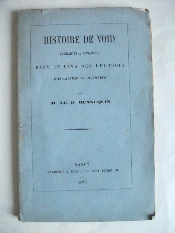
HENNEQUIN Docteur
Histoire de Void
(Noniantus ou Noviantus)dans le pays des Leuquois depuis l’an 50 avant Jésus Christ jusqu’à nos jours.In 8 broché,faux titre,titre,76 pages en partie non coupé. Une lithographie hors-texte,figures dans le texte, cartes dans le texte et pleine page.3 cartes et un plan dépliants (jardins de la Louvière)Imprimerie E.Réau 1876.Edition originale Rousseurs éparse plus ou moins fortes.Rare
Bookseller reference : 3675
|
|
|
HENRY (Maurice).
Maurice Henry Dessins.
Paris Galerie des 2 îles 1946 1 vol. Broché plaquette in-8 agrafée, 4 ff. Invitation à une exposition de dessins de Maurice Henry du 22 décembre 1946 au 12 janvier 1947, avec un poème de 4 pages de Jacques Prévert intitulé "Un beau jour..." Rare.
Bookseller reference : 120521
|
|
|
HENROT-BROUHON Thérèse.
NEVERS A LA BELLE EPOQUE (cartes postales anciennes)
SPRL, 1975, un volume in-8 oblong , 20,5 x15 cm, reliure toile éditeur ornée et illustrée, 116 reproductions de cartes postales anciennes. Bon état.
Bookseller reference : 6809
|
|
|
HENRIOT, J.N.
Plan de Paris en 1861 divisé en 20 arrondissements
1 carte dépliante en couleurs, format 62 x 89 cm, Chez A. Bes et F. Dubreuil, Paris, 1861
Bookseller reference : 47981
|
|
|
HENROT-BROUHON Thérèse.
VERSAILLES A LA BELLE EPOQUE (cartes postales anciennes)
SPRL, 1975, un volume in-8 oblong , 20,5 x15 cm, reliure toile éditeur ornée et illustrée, 116 reproductions de cartes postales anciennes. Excellent etat.
Bookseller reference : 7979
|
|
|
HENRIOT, J.N.
Plan de Paris en 1861 divisé en 20 arrondissements
1 carte dépliante en couleurs, format 62 x 89 cm, Chez A. Bes et F. Dubreuil, Paris, 1861 Charmante carte lithographiée en couleurs de Paris au temps du baron Haussmann. Bon état (minimes usures et fentes en plis, cachet de colportage au verso). Français

|
|
|
Henry A & Kent Charles Foster Sherman; Illustrator Illustrated by 158 Maps/Charts & 8 Photos
The Children's Bible Scribner's Illustrated Editions Series
Charles Scribner's Sons 1937. Hardcover. Acceptable. Charles Scribner's Sons hardcover
Bookseller reference : 111107338
|
|
|
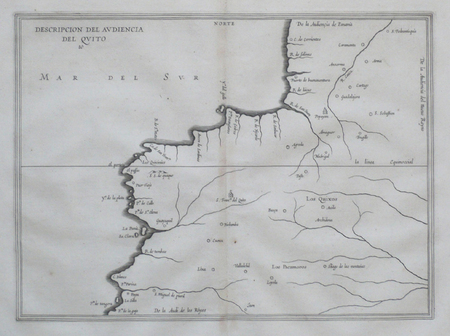
HERRERA Y TORDESILLAS (Antonio de).
[COLOMBIE/EQUATEUR] Descripcion del audiencia del Quito.
[Amsterdam, 1622]. 211 x 288 mm.
Bookseller reference : LBW06217
|
|
|
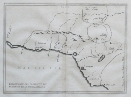
HERRERA Y TORDESILLAS (Antonio de).
[MEXIQUE] Descripcion del destricto del audiencia de la Nueva Galicia.
[Amsterdam, 1622]. 213 x 291 mm.
Bookseller reference : LBW066c0
|
|
|
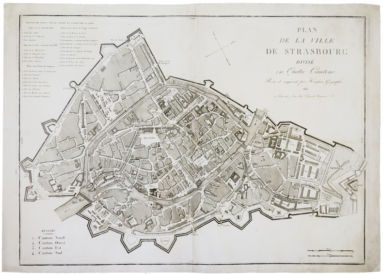
HERISSON (Eustache).
[STRASBOURG] Plan de la ville de Strasbourg divisé en quatre cantons.
Paris, Jean, 1836. 535 x 755 mm.
Bookseller reference : LBW-4455
|
|
|
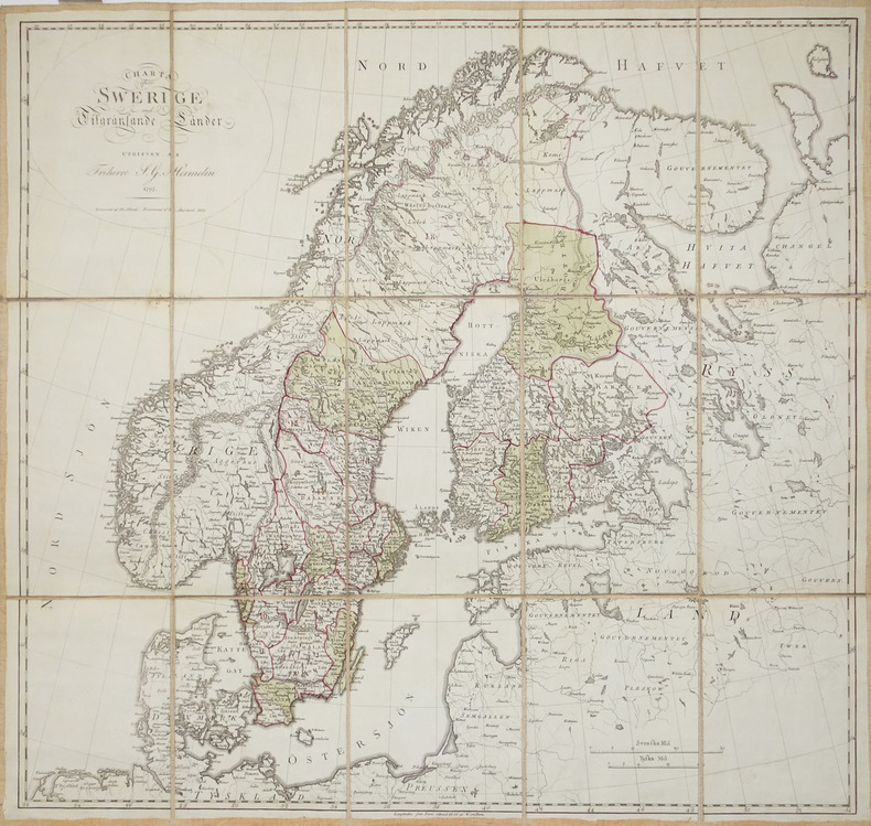
HERMELIN (Samuel Gustav).
[SUEDE] Charta öfwer Swerige med Tilgränsande Länder.
1797-1809. En 15 sections montées sur toile et pliées, formant une carte de 577 x 611 mm.
Bookseller reference : LBW-2930
|
|
|
HERZOG Maurice; DEVIES Lucien (préf.):
Annapurna premier 8.000.
Paris / Grenoble, Arthaud, collection Sempervivum, 1952. In-8 broché de 293-[15] pages, jaquette illustrée.
Bookseller reference : 19729

|
|
|
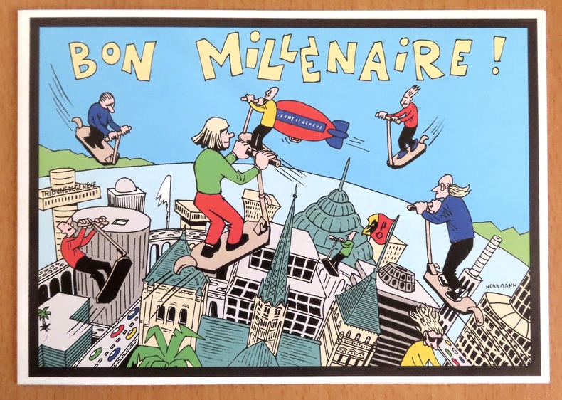
Herrmann:
Bon millénaire !
Tribune de Genève, 2000. Carte de voeux du quotidien, pliante, illustrée par Herrmann.
Bookseller reference : 8567

|
|
|
Hergé:
Canot du Crabe aux Pinces d'Or. Sérigraphie en 2 états.
Lausanne, La Marge. Sérigraphie au format 25,5 x 18,5 cm. En deux états, soit un essai annoté des passages couleurs et la version définitive, au tirage limité à 200 exemplaires numérotés, la nôtre numéro 110.
Bookseller reference : 6311

|
|
|
HERODOTO, BECELLI (Trad.)
Erodoto Alicarnaso padre della Greca istoria con la vita d Homero tradotto dal Sr Giulio Cesare Becelli gentiluomo Veronese…..
Verona, Giolito, 1733, 2 volumes in-4, 8ff.-424pp.-2ff. et 224pp.-50ff.-XXX ; relié demi basane époque, dos à nerfs avec pièces de titre rouge et tomaisons vertes, tranches mouchetées rouge, frottements, petit manque au dos.
Bookseller reference : PHO-1806

|
|
|
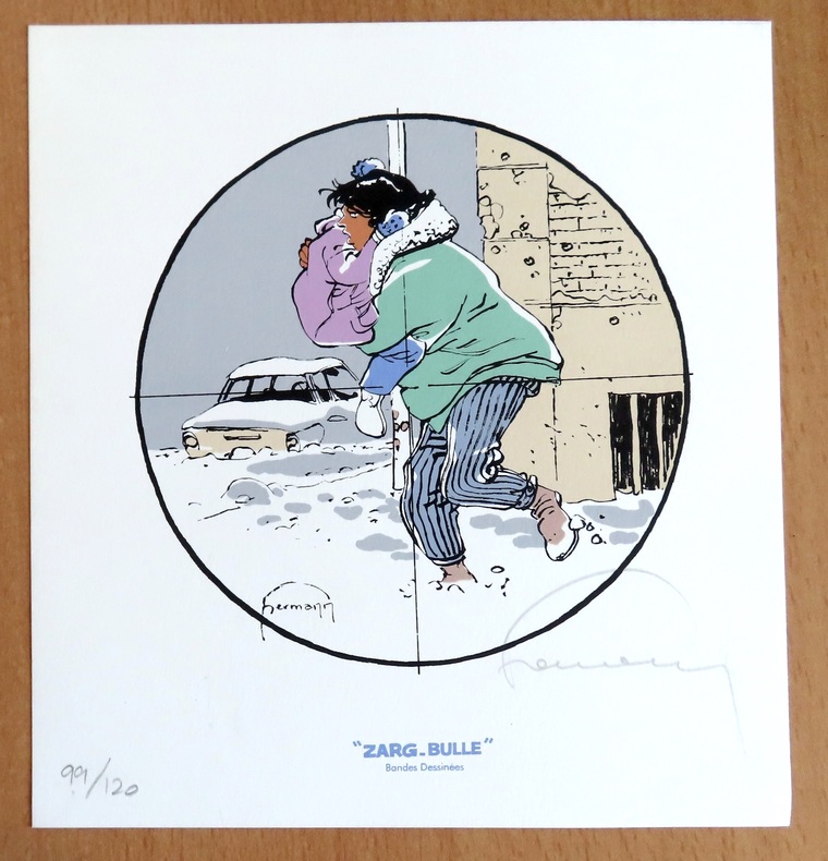
Hermann:
Ex libris Zarg-Bulle.
Zarg-bulle. Ex libris au format 18,5 x 20 cm. A l'état de neuf.
Bookseller reference : 24394
|
|
|
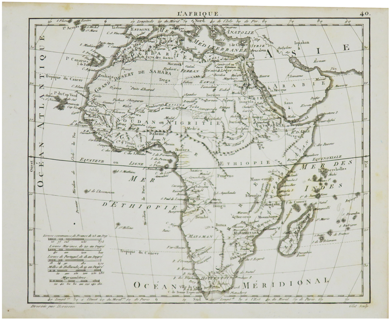
HERISSON (Eustache).
L'Afrique.
[1806]. 178 x 215 mm.
Bookseller reference : LBW024b9
|
|
|
HERZOG Maurice (direction); COURTHION Pierre; COUZY Jean; ESCARRA Jean; et al.
La montagne
Paris Librairie Larousse 1956 Fort volume in-4 de 474 pages, pleine reliure en skivertex vert foncé sous sa jaquette à rabats illustrée en couleurs, titre doré, tranches jaspées. Jaquette fatiguée, autrement très bon état.
Bookseller reference : 16828
|
|
|
HERALD Georges W. et Edward D. RADIN
MONTE-CARLO : un siècle de roulette.
broché - 15,5x21,5 - 267 pp - 1964 - éditions de trevise, Paris.Collection "le dessous des cartes ". Photographies hors texte.
Bookseller reference : 6989
|
|
|
HERALD (George W.) et RADIN (Edward D).
Monte-Carlo : Un siècle de roulette.
Paris, Trévise, Collection "Le dessous des cartes", 1964 ; in-8, broché, couverture illustrée, 265 pp.
Bookseller reference : 7437
|
|
|
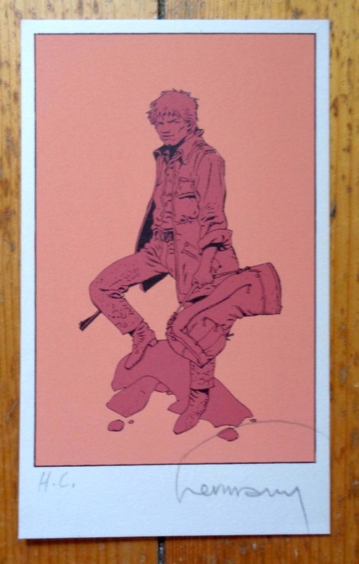
Hermann:
Petite sérigraphie signée.
Petite sérigraphie à l'état de neuf. Tirage nom mentionné, celle-ci marquée HC, signée par Hermann.
Bookseller reference : 5036
|
|
|
Hermann:
Voeux de la Tribune de Genève pour le 3e millénaire.
Tribune de Genève, 1999. Carte double au format fermé de 21 x 15 cm.
Bookseller reference : 24397
|
|
|
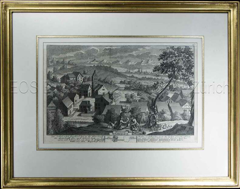
Herrliberger, David:
Weiningen.
1741. Kupferstich. Bildausschnitt: 119 x 28,5 cm. Rahmen: 34,5 x 44 cm.
Bookseller reference : 604BG
|
|
|
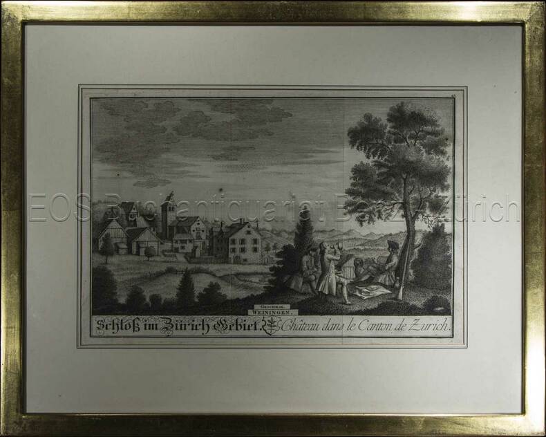
Herrliberger, David:
Weiningen.
1743. Kupferstich. Bildausschnitt: 20 x 28 cm. Rahmen: 33,5 x 42 cm.
Bookseller reference : 605BG
|
|
|
HERALD (George W.) et RADIN (Edward D).
Monte-Carlo : Un siècle de roulette.
Paris, Trévise, Collection "Le dessous des cartes", 1964 ; in-8, broché, couverture illustrée, 265 pp. Planches hors-texte.
|
|
|
Herdman T. Maps by Ric Wylam
Rivers of Europe Longmans Colour Geographies. Unit 19;
London Longmans 1965;. 3rd impression. Sofrcover. Very good condition. 40pp. Maps by Ric Wylam. . London, Longmans, 1965; unknown
Bookseller reference : 19615
|
|
|
Herguido Cartes Baltasar
Electricidad corriente continua
1900. Paperback. Very Good-New. Rare book paperback
Bookseller reference : 544864 ISBN : 8450560950 9788450560954
|
|
|
Herguido Cartes Baltasar
Electricidad y montaje
1988. Paperback. Very Good-New. Rare book paperback
Bookseller reference : 544877 ISBN : 8450570816 9788450570816
|
|
|
HERISSON
Carte du Royaume d'Irlande, dressée par Hérisson, Elève du Cit. Bonne, ancien Ingénieur hydrographe de la Marine. 1805
1 grande carte 57 x 85 cm, frontières rehaussées en couleur, Chez Basset, Paris, 1805 Etat très satisfaisant (deux petites coupures en pliure centrale, marges lég. frottée, bel état par ailleurs). Français

|
|
|
Herkenhoff, Michael
Die Darstellung außereuropäischer Welten in Drucken deutscher Offizinen des 15. Jahrhunderts.
Berlin, Akademie-Verlag, 1996. 350 S. Mit Abb. 25 cm. OPp.
Bookseller reference : 95173

|
|
|
Herlin Emil Maps and Brown Francis Text
The War in Maps : An Atlas of the New York Times Maps
Oxford University Press. Used - Good. Shows some signs of wear and may have some markings on the inside. Oxford University Press unknown
Bookseller reference : GRP117376851
|
|
|
Herlin Emil Maps and Brown Francis Text
The War in Maps : An Atlas of the New York Times Maps
Jan 01 1943. Hardcover. Good. hardcover
Bookseller reference : 40-JI0U-FL0Z
|
|
|
HERNANDO RICA, Agustín.
Coleccionismo Cartográfico en el Siglo XVII. Ejemplares reunidos por Vincencio Juan de Lastanosa (1607-1681) y su significado.
Huesca, 2007. 4to. apaisado; 92 pp. Ilustraciones. Cubiertas originales.

|
|
|
HERNANDO RICA, Agustín.
La imagen de un país. Juan Bautista Labaña y su Mapa de Aragón (1610-1620).
Zaragoza, IFC, 1996. Folio; 158 pp., impresas a doble columna y 69 reproducciones de mapas. Cubiertas originales.

|
|
|
HERNÁNDEZ MILLARES, Jorge.
Atlas del Viejo Mundo.
México, Fondo de Cultura Económica, 1964. 4to. menor; 58 pp. y 42 mapas aparte. Enc. original en tela.

|
|
 Receive by email
 Download as PDF document
 RSS feed


