|
Elizabeth Stuart on Armada Maps of Plymouth David Webb on James Baker's Plans of Wales Sue Brenchley on her Cornish junkshop
Map Collector Spring 1988 Issue No. 42
Map Collector Publications. Used - Very Good. Very Good condition. Spring 1988 Issue No. 42. Map Collector Publications unknown
Referência livreiro : S13J-00403
|
|
|
Elkins, T. H.
Germany
334 pages maps, tables, index. eng
|
|
|
Ellingham, Mark; McVeigh, Shaun; Jacobs, Daniel and Brown, Hamish
The Rough Guide to Morocco (seventh edition)
No inscriptions or marks. No creasing to covers or to spine. A lovely clean crisp very tight copy with bright unmarked boards and no bumping to corners. Looks unused. 798pp.

|
|
|
Elliott (Bruce)
Précis de prestidigitation cartomagie
1970 Paris Payot 1970 In8 broché 247 pages
Referência livreiro : 6338
|
|
|
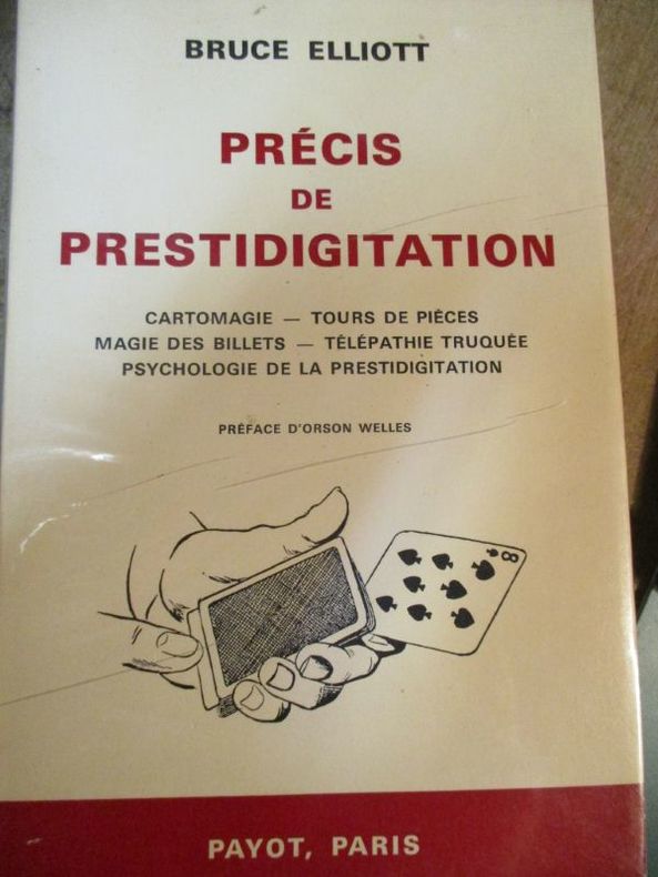
ELLIOTT Bruce
PRECIS DE PRESTIDIGITATION. Cartomagie - Tours de pièces - La magie des billets - Télépathie truquée - Psychologie de la prestidigitation.
Payot Paris 1970 In-8 ( 225 X 140 mm ) de 247 pages, broché sous couverture illustrée. Préface d'Orson Welles. Traduction de Pierre Lanoé. Illustrations de L. Vosburgh Lyons. Illustrations dans et hors-texte. Très bel exemplaire, non coupé.
Referência livreiro : 857484
|
|
|
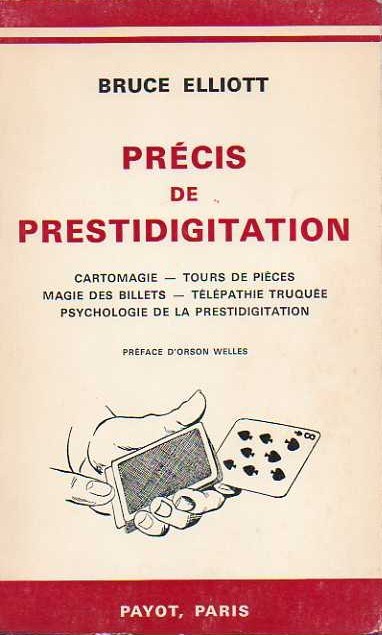
ELLIOTT Bruce
PRÉCIS DE PRESTIDIGITATION, Cartomagie, Tours de Pièces, Magie des Billets, Télépathie truquée, Psychologie de la Prestidigitation
Ed. Payot, Paris, 1970, broché, couverture illustrée, 72 illustrations de L. VOSBURGH Lyons, 248 pages, 14x22.5
Referência livreiro : BLG00011
|
|
|
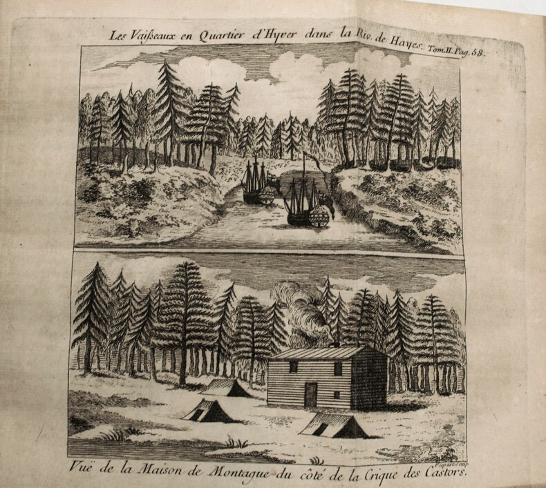
ELLIS , Henry
Voyage de la baye de Hudson. Fait en 1746 & 1747, pour la découverte du passage de Nord-Ouest.
Paris, Antoine Boudet T1, Ballard T2, 1749. 2 volumes in-12, reliures différentes ,lvi-182pp-2ff ,2ff-319pp. , illustré de 10 gravures la plus part dépliantes et 1 carte .Édition originale de la traduction française, par Gottfried Sellius, publiée un an après l'originale anglaise.Elle est ornée d'une carte dépliante de la baie de Hudson et de dix planches hors texte, gravées par Flipart.
Referência livreiro : PHO-1093
|
|
|
Ellison Walter G.; illustrations and maps by Nancy L. Martin
GUIDE TO BIRD FINDING IN VERMONT
Woodstock VT: Vermont Inst. of Natural Science. VG/No Dustjacket. 1983. . Paperback. 8vo. 134 pp. edges rubbed spine fading . Vermont Inst. of Natural Science paperback
Referência livreiro : BOOKS268675
|
|
|
ELSDORF, Michel.
Petits Metiers et Cris des rues au pays de Liège.
Hardcover in-4, 111 pages, entièrement illustré en n-b, cartonnage illustre. Bel exemplaire bien complet du DISQUE VINYLE 45 tours. [VU-8]
|
|
|
ELSDORF, Michel.
Petits Metiers et Cris des rues au pays de Liège.
Bruxelles, Libro-Sciences, 1989. Hardcover in-4, 111 pages, entièrement illustré en n-b, cartonnage illustre.
Referência livreiro : 79969
|
|
|
Elston, Roy
Off the Beaten Track in Southern France
No marks or inscriptions. No creasing to covers or to spine. A very clean very tight copy with bright unmarked boards, very slightly dusty page edges, clear gilt lettering to spine and no bumping to corners. 332pp. Long before the age of cheap overseas travel, the author guides us on a tour of Southern France centred around the Cevennes. Illustrated and with map at rear end paper. He documents the costs of the trip which are interesting.

|
|
|
Ely, Bertha Comins; Johnson, Arthur; Bridges, H. Styles; Felker, Andrew L.; Upham, George B.; Metcalf, Henry H.
The Granite Monthly - A New Hampshire Magazine - May, 1923: American Legion Feature
Pages 197-249. Black and white photos. Features: Nice full-page photo portrait of Major Charles S. Walker, N.H. Department Commander American Legion; For God and Country - The American Legion - A New Hampshire Asset - major article with many great photos; The Legion - Maker of Americans - an interview with Maurice F. Devine; Behind the Lines; Behind the Lines - The American Legion Auxiliary at work; State Executive Board of the American Legion Auxiliary; A Portrait Gallery of Legionnaires - excellent photos with write-ups of selected individuals; New Hampshire's Labor Commissioner; Their Son; An Anthology of One Poem Poets; Over the Top with Ayrshires - The Sawyer Herd and Farrm Buildings - article with nice photos; In the Springtime; When Claremont was called Ashley III - Two English Maps of Revolutionary Times; Current opinion in New Hampshire; Old Home Week and the Tercentenary; Books of New Hampshire Interest; The Editor Stops to Talk; New Hampshire Necrology. Average wear and soiling. A sound vintage copy of this particularly excellent issue. Magazine

|
|
|
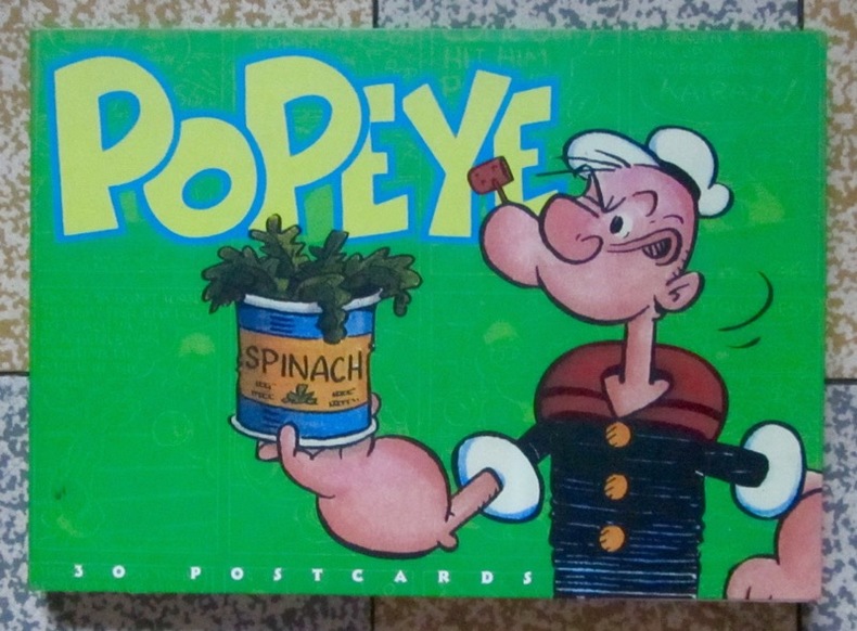
Elzie Crisler Segar:
Popeye - 30 postcards.
Stewart, Tabori and Chang, 1997. 30 cartes postales de l'amateur d'épinards, sous couverture illustrée couleurs. Trace d'étiquette de prix au second plat, pour le reste à l'état de neuf.
Referência livreiro : 4426
|
|
|
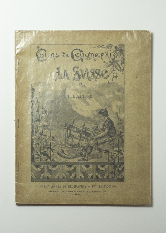
ELZINGRE Henri:
La troisième année de géographie. Manuel-atlas illustré. La Suisse.
Berne, Schid & Francke, 1901. In-4 broché de 67-[3] pages, couverture illustrée.
Referência livreiro : 16255
|
|
|
Emerson Edwin and Marion Mills Miller; Illustrated by Maps 8 Colored Plates Eng Illustrator
NINETEENTH CENTURY AND AFTER A History Year by Year from A. D. 1800 to the Present Vol I 1800-1821
P. F. Collier & Son 1906-01-01. Hardcover. Good. P. F. Collier & Son hardcover
Referência livreiro : 190515005
|
|
|
ENCICLOPEDIA ILUSTRADA SEGUI - Tomo 1 (primera parte) 46 planches en couleurs, cartes, plans de villes, etc.
Diccionario universal con todas las voces y locuciones usadas en España y en la América latina. Tomo I. (A primera parte). Contiene también todas las equivalencias en francés, inglés é italiano del léxico castellano y de la inmensa mayoría de voces de la técnica moderna.
Couverture rigide. Reliure demi-basane rouge. 576 pages.
Referência livreiro : 128913
|
|
|
ENCICLOPEDIA ILUSTRADA SEGUI - Tomo 1 (segunda parte) 60 planches en couleurs, cartes, plans de villes, etc.
Diccionario universal con todas las voces y locuciones usadas en España y en la América latina. Tomo I. (A : Segunda parte - desde Amzulla al final). Contiene también todas las equivalencias en francés, inglés é italiano del léxico castellano y de la inmensa mayoría de voces de la técnica moderna.
Couverture rigide. Reliure demi-basane rouge. 550 pages.
Referência livreiro : 128914
|
|
|
ENCICLOPEDIA ILUSTRADA SEGUI - Tomo 10 (Hi-Iz) 28 planches en couleurs, cartes, plans de villes etc.
Diccionario universal con todas las voces y locuciones usadas en España y en la América latina. Tomo X : desde Hi a Izzi. Contiene también todas las equivalencias en francés, inglés é italiano del léxico castellano y de la inmensa mayoría de voces de la técnica moderna.
Couverture rigide. Reliure demi-basane rouge. 519 pages.
Referência livreiro : 128923
|
|
|
ENCICLOPEDIA ILUSTRADA SEGUI - Tomo 11 (Hi-Iz) 20 planches en couleurs, cartes, plans de villes, etc.
Diccionario universal con todas las voces y locuciones usadas en España y en la América latina. Tomo XI : desde J a Lazzisk. Contiene también todas las equivalencias en francés, inglés é italiano del léxico castellano y de la inmensa mayoría de voces de la técnica moderna.
Couverture rigide. Reliure demi-basane rouge. 638 pages.
Referência livreiro : 128924

|
|
|
ENCICLOPEDIA ILUSTRADA SEGUI - Tomo 2 (B) 90 planches en couleurs, cartes, plans de villes, etc.
Diccionario universal con todas las voces y locuciones usadas en España y en la América latina. Tomo 2. (B). Contiene también todas las equivalencias en francés, inglés é italiano del léxico castellano y de la inmensa mayoría de voces de la técnica moderna.
Couverture rigide. Reliure demi-basane rouge. 841 pages.
Referência livreiro : 128915

|
|
|
ENCICLOPEDIA ILUSTRADA SEGUI - Tomo 3 (primera parte de C) 48 planches en couleurs, cartes, plans de villes, etc.
Diccionario universal con todas las voces y locuciones usadas en España y en la América latina. Tomo 3. (desde C a Cazziol). Contiene también todas las equivalencias en francés, inglés é italiano del léxico castellano y de la inmensa mayoría de voces de la técnica moderna.
Couverture rigide. Reliure demi-basane rouge. 665 pages.
Referência livreiro : 128916
|
|
|
ENCICLOPEDIA ILUSTRADA SEGUI - Tomo 4 (segunda parte de C) 55 planches en couleurs, cartes, plans de villes, etc.
Diccionario universal con todas las voces y locuciones usadas en España y en la América latina. Tomo I. (C : Segunda parte - desde C.B. a Coovea). Contiene también todas las equivalencias en francés, inglés é italiano del léxico castellano y de la inmensa mayoría de voces de la técnica moderna.
Couverture rigide. Reliure demi-basane rouge. 691 pages.
Referência livreiro : 128917
|
|
|
ENCICLOPEDIA ILUSTRADA SEGUI - Tomo 5 (tercera parte de C) 51 planches en couleurs, cartes, plans de villes, etc.
Diccionario universal con todas las voces y locuciones usadas en España y en la América latina. Tomo I. (C : Tercera parte - desde C.O.P. a Chytroglossa). Contiene también todas las equivalencias en francés, inglés é italiano del léxico castellano y de la inmensa mayoría de voces de la técnica moderna.
Couverture rigide. Reliure demi-basane rouge. 784 pages.
Referência livreiro : 128918

|
|
|
ENCICLOPEDIA ILUSTRADA SEGUI - Tomo 6 (D) 31 planches en couleurs, cartes, plans de villes, etc.
Diccionario universal con todas las voces y locuciones usadas en España y en la América latina. Tomo VI : D. Contiene también todas las equivalencias en francés, inglés é italiano del léxico castellano y de la inmensa mayoría de voces de la técnica moderna.
Couverture rigide. Reliure demi-basane rouge. 695 pages.
Referência livreiro : 128919
|
|
|
ENCICLOPEDIA ILUSTRADA SEGUI - Tomo 7 (E) 53 planches en couleurs, cartes, plans de villes, etc.
Diccionario universal con todas las voces y locuciones usadas en España y en la América latina. Tomo VII : E. Contiene también todas las equivalencias en francés, inglés é italiano del léxico castellano y de la inmensa mayoría de voces de la técnica moderna.
Couverture rigide. Reliure demi-basane rouge. 792 pages.
Referência livreiro : 128920
|
|
|
ENCICLOPEDIA ILUSTRADA SEGUI - Tomo 8 (F-Ga) 25 planches en couleurs, cartes, plans de villes, etc.
Diccionario universal con todas las voces y locuciones usadas en España y en la América latina. Tomo VIII : desde F. a Gazzueolo. Contiene también todas las equivalencias en francés, inglés é italiano del léxico castellano y de la inmensa mayoría de voces de la técnica moderna.
Couverture rigide. Reliure demi-basane rouge. 665 pages.
Referência livreiro : 128921

|
|
|
ENCICLOPEDIA ILUSTRADA SEGUI - Tomo 9 (Gb-Hh) 53 planches en couleurs, cartes, plans de villes, etc.
Diccionario universal con todas las voces y locuciones usadas en España y en la América latina. Tomo IX : desde Gbebe a HHonson. Contiene también todas las equivalencias en francés, inglés é italiano del léxico castellano y de la inmensa mayoría de voces de la técnica moderna.
Couverture rigide. Reliure demi-basane rouge. 665 pages.
Referência livreiro : 128922

|
|
|
ENCYCLOPEDIA COLOR MAPS Colange L. Bartholomew J. mapmaker.
Zell's Popular Encyclopedia A Universal Dictionary of English Language Science Literature and Art. In Two Volumes. New and Revised Edition. With Eighteen Colored Maps and Illustrated with nearly Three Thousand Wood Cuts.
T. Ellwood Zell Davis & Co. Phi 1877-01-01. Hardcover. Good. . 2-volume set 1874 edition. Covers show minor wear and tear rubbing and soiling. Some interior pages detached and show heavy chipping. Pages are lightly tanned but mostly clean text and pictures are intact and unmarred. T. Ellwood Zell, Davis & Co. Phi hardcover
Referência livreiro : mon0001511693
|
|
|
ENCYCLOPEDIA COLOR MAPS Colange L. Bartholomew J. mapmaker.
Zell's Popular Encyclopedia A Universal Dictionary of English Language Science Literature and Art. In Two Volumes. New and Revised Edition. With Eighteen Colored Maps and Illustrated with nearly Three Thousand Wood Cuts.
Philadelphia.: T. Ellwood Zell Davis & Co. 1877. TWO VOLUMES IN FOUR BOUND BOOKS. Eighteen full page color maps tipped in black and white in-text illustrations marbled endpapers and edges 2576pp gilt lettered leather spine and leather corners with cloth-covered boards hardbound. Covers rubbed with some shorts tears to leather spine and corners; hinges starting to split on two volumes but still well attached; faint dampstain to upper right corner of first volume otherwise interiors in very good bright and clean condition. This antique encyclopedia features a color frontispiece "Flags of All Nations" plus maps of Asia "Chinese Empire and Japan" Africa South America Austro-Hungary Europe Australia with map of New Zealand on half of verso "India Afghanistan Beloochistan Burmah and Siam" Ireland "Italy Turkey in Europe Greece Roumania Servia &c." Palestine Ancient and Modern Scotland "Turkey in Asia Persia Arabia Egypt & Nile Countries" General Map of the United States "The World on Sir J. Herschel's Projection" etc. A heavy volume which may entail extra shipping charges. . T. Ellwood Zell, Davis & Co. hardcover
Referência livreiro : 44876
|
|
|
Endrès, André
Tourisme au nord de la Seine-et-Marne . 1. Tourisme au nord de la Seine-et-Marne. Meaux et ses environs.
Amatteis, 1987, in 4 broché, 167 pages, abondante iconographie ( photos, documents, cartes...). Bon état.
Referência livreiro : 6560
|
|
|
Engelbrecht Thiess Hinrich
Die Feldfr�chte Indiens in ihrer geographischen Verbreitung. Zweiter Teil : Atlas von 23 Karten. Abhandlungen des Hamburgischen kolonialinstituts Band. XIX. Reihe E. Angewandte naturwissenschaften landwirtschaft und technologie band 3
Hamburg: L. Friedrichsen & Co 1914. Livre. Assez bon. Cartonnage �diteur. Ed. originale. In-folio. Hamburg L. Friedrichsen & Co 1914. 395 x 41 cm in-folio 3 ff. n. ch. - 23 cartes en couleurs dont l'une d�pliante mont�es sur onglets cartonnage imprim� de l'�diteur. Atlas seul. Peu commun. Cotes et tampons de biblioth�que gratt�s manques de toile au dos. L. Friedrichsen & Co Hardcover
Referência livreiro : 2139

|
|
|
Engelbrecht Martin (1684 - 1756)
Roma
Panorama della città da Monte Mario. Disegnato da Friedrich Berhard Werner, incisa da Johann Georg Ringlin e pubblicata da Martin Engelbrecht (1684 - 1756). "Al centro in basso scudo con scritta obliqua SPQR. In alto al centro sopra il titolo N. 40. In basso 82 numeri di legenda. Sono ben visibili non solo il porto di Ripetta ma anche la scalinata di Trinità dei Monti (1723-26) da cui la datazione al 1730 ca. Questa veduta fa parte di una serie di profili della città che hanno come probabile prototipo quella più grande incisa da Werner verso il 1730 (in basso a sinistra sta scritto Fridr. Bernh. Werner del.): si vedano tra l'altro l'identica deformazione verticale di tutti i monumenti (ed in particolare di Castel Sant'Angelo) ed il modo di raffigurare i campi coltivati in primo piano" (cfr. Marigliani, p. 266). Incisione in rame, buone condizioni. Rara. Panorama of the city from Monte Mario. Drawn by Friedrich Berhard Werner, engraved by Johann Georg Ringlin and published by Martin Engelbrecht (1684 - 1756). At center below, shield with oblique inscription SPQR. Bottom 82 numbers of legend. Not only the port of Ripetta but also the Spanish Steps are clearly visible (1723-26), hence the dating to about 1730. This view is part of a series of profiles of the city that have as their probable prototype the larger one engraved by Werner around 1730 (at lower left is written Fridr. Bernh. Werner del.): see among other things the identical vertical deformation of all the monuments (and in particular of Castel Sant'Angelo) and the way of depicting the cultivated fields in the foreground. (see Marigliani, p. 266). Copper engraving, good condition. Rare. C. Marigliani, "Le Piante di Roma delle collezioni private", tav. 182.

|
|
|
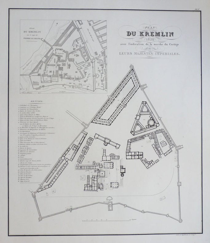
ENGELMANN (Godefroy).
Plan du Kremlin 1826 avec l'indication de la marche du cortège de leurs Majestés Impériales.
[1828]. 540 x 464 mm.
Referência livreiro : LBW-975
|
|
|
Engers, Joe: Editor
The Great Book of Wildfowl Decoys
320 pages. Presents decoys in the most sensible and comprehensive way: by region, with each region discussed by a recognized expert in that area. Thus the entire range of decoys is covered, from Canada down the Atlantic Coast and inland along streams and rivers to Louisiana and up the Mississippi to the Great Lakes and across to California and Oregon. Also included are chapters on European decoys, the history of decoys, how decoys were made, and how to go about collecting decoys. A list of public collections of decoys, a bibliography, a record of top auction prices, maps of waterfowl flyways, and an index complete the package. Beautifully illustrated with colour photography throughout. Gift greetings upon front endpaper else book clean, bright and unmarked with very light wear. Dust jacket bears tape-repaired tear to central portion of front panel and large chunk missing from base of back flap. A small part of this chunk is from bottom corner of back panel. Other than this, dust jacket is bright and attractive with moderate wear. Overall, a nice copy of this most substantial work. Book
|
|
|
ENGLAND PICTORIAL ROAD MAPS Sylvanus Urban Edward Cave.
Gentleman's Magazine. 1765.
London.: "Printed for D. Henry and R. Cave at St. John's Gate". 1765. Bound volume of ‘The Gentleman’s Magazine" for the year 1765 8 ¼ x 5 inches 617 pp. plus 9 pp "Index" divided into discreet categories Essays Poetry Names etc. Volume contains six engraved pictorial maps generally centered on travel from London to the outlying destinations described below. Maps are of various sizes with 8 x 12 ½ inches being normative. 1. "A Map of the Road from London to Chester measur’d from the Royal Exchange" approx. 8 x 12 ½ inches. Light offset from ink stamp on opposing page. 2. "A Map of the Roads from London to Bristol and Bath measur’d from the Royal Exchange" approx. 8 x 12 ½ inches. 3. "A Map of the roads from Dover Rye Hith Margate Ramsgate and Deal" approx. 8 x 12 ½ inches. Light damp stain in top bargain above printed title. 4. "A Map of the roads from London to Portsmouth Chichester Southampton Pool & from Southampton to Winchester." Virtually no margin along left edge of map. Right edge tightly bound in volume. Three light spots of toning associated with earlier pages replicated due to folds as issued in map. 5 "A Map of the Roads from London thro Oxford Worcester etc. to Aberistwith" with "The Road from Bristol to Exeter" 7 ¾ x 11 ½ tightly bound on left margin. 6 "An Accurate Map of the Road from London to the Lands End in Cornwall Passing thro Salisbury Exeter…" etc. etc. 8 x 17 inches cropped on left free edge impacting map although the route from London remains clear. A number of library stamps throughout the volume with these noted in the map description No. 1 above. Overall a tightly bound volume good clean condition with issues noted. Volume contains additional illustrated material generally in good clean condition. . "Printed for D. Henry and R. Cave at St. John's Gate". unknown
Referência livreiro : 54469

|
|
|
ENGLAND LONDON POCKET MAPS
Sunday Telegraph Map of Central London and Sunday Telegraph Map of London's Approaches.
London.: Sunday Telegraph. No date. Circa 1965. Folder 3 x 4 1/8 inches containing two colorful folding London maps opening to 7 x 8 inches each. First map depicts central London while second map depicts London and its surroundings. Two small black and white maps on rear panels of folder depict locations of Cinemas and Theatres. The Central London map locates the Royal Festival Hall 1951 but not the Hayward Gallery 1968 or Royal National Theatre 1976 suggesting a mid-60s date of publication. An engaging cartographic novelty in excellent clean condition. . Sunday Telegraph. unknown
Referência livreiro : 54319

|
|
|
ENGLAND / WALES / SCOTLAND ROAD MAPS
Cary's New Itinerary.
London.: G. & J. Cary. "Tenth Edition with Improvements". 1826. Hard cover volume 8 1/4 x 5 inches 1071 pages with eight folded maps the average unfolded size of maps 2 through 8 is 7 1/2 x 9 1/4 inches. Volume remains tightly bound with dings to corners of covers and loss of paper on the spine. Name inscribed in ink on front pastedown. Descriptive paper 2 1/2 x 3 inches pasted to spine contains title and brief summary of the volume's scope. "The Work shows the Immediate Route from the Metropolis to all parts of England and Wales.with many of the principal roads in Scotland." Also depicted: navigable canals course of rivers passed over stage coaches and their routes etc. The maps included in this massive work are: 1. Large Folding Map of England and Wales in two sheets 2. Map of the Isle of Wight 3. Map with Environs of London 4. Map with Environs of Bath 5. Map with Little Hampton Bognor Worthing Arundel and the Environs of Brighton 6. Map with Environs of Margate and Ramsgate 7. Map with Environs of Cheltenham 8. Environs of the Lake District . G. & J. Cary. hardcover
Referência livreiro : 55020

|
|
|
ENGLAND / WALES / MAPS & ENGRAVED PLATES Grose Frances.
The Antiquities of England and Wales.
London.: S. Hooper. No date. Ca. 1787. EIGHT VOLUMES new edition tall octavo. Large folding handcolored index map 54 hand colored half page county maps numerous engravings and some plans. Two early gatherings in volume 1 transposed without loss pp. 33-40 and 41-48 plan of Barnard Castle in volume 2 bound in upside down occasional browning particularly on early leaves of volume 8 some offsetting of color onto verso of maps. Richly bound in calf covered boards and decorative spines gilt dentelles ribbon markers marbled endpapers a most handsome set in good firm condition. A few pages considerably browned mostly not affecting images one tiny edge tear to title page of volume one no pages missing. Map of Merionshire appears never to have been bound in. A highly desirable set in beautiful leather binding. The 160 page preface to the work in volume 1 and its addenda includes comment on castles monasteries architecture Domesday Book and druidical monuments. The county index follows and continues in the subsequent volumes detailing much interesting information regarding the antiquities of each county concluding with further information in volume 8 the supplement volume. The map of Rutland is also placed here. . S. Hooper. hardcover
Referência livreiro : 38602

|
|
|
Engle, Eloise; Paananen, Lauri
The Winter War: The Russo-Finnish Conflict, 1939-40
176 pages including index, bibliography and appendices. Black and white illustrations. Maps. "For months the Finns, who received scant help from an admiring world of sympathizers and avowed allies, held on. Yet the holding could only last until the Russians gathered themselves. When that happened and Red wheel-to-wheel artillery attacks and new hordes of troops and tanks again took their toll, the Finns bowed to the inevitable defeat... Describes the big picture and relates the stories of many individual Finns and Russians in combat. The result is a fascinating and moving book." - from dust jacket. Usual library markings. Above-average wear. Worthy reading copy. Book
|
|
|
Engraved Printed and Published by: The George R. Cram Company Inc. & School Maps Atlases and Globes Mpa Makers Since 1867
Cram's New Modern World Atlas
1956-01-01. Hardcover. Good. Hardcover. Pages are clean and unmarked. Covers show light edge wear with rubbing/light scuffing. Binding is tight hinges strong. Previous owners name on end paper.; 100% Satisfaction Guaranteed! Ships same or next business day! hardcover
Referência livreiro : 132006090033
|
|
|
ENTRECASTEAUX (Dentrecasteaux ,J.-A. de Bruni, d'), ROSSEL (Éd. De, rédacteur)
Voyage de Dentrecasteaux, envoyé à la recherche de La Pérouse, publié par ordre de Sa Majesté l'Empereur et Roi, sous le ministère de S. E. le vice-amiral Decrès, comte de l'Empire.
Paris, Imprimerie impériale, 1808. 2 grands et forts volumes in-4 (32x24), lvi, 704 p., 33 pl. ; viii, 692 p., relié demi basane et coins moderne, dos avec auteur, titre, tomaison, lieu et date, exlibris en page de garde, non rogné, tome 2 non coupé, petite mouillure au tome 2, petites rousseurs aux illustrations du tome 1. Exemplaire sur papier bleuté, complet de son illustration mais sans son atlas de cartes
Referência livreiro : PHO-1626
|
|
|
Environment Canada
British Columbia Land Capability for Wildlife - Waterfowl: 1:1,000,000 - Canada Land Inventory: Two Fold-out Maps
Catalogue No. En 64-14w/7N-7S. Folds open to reveal two large fold-out maps. Average wear. Minimal markings. A sound working copy. Book

|
|
|
ENVIRONS DE ROUEN
Carte au 1/80 000?me. Sans date.
Une feuille. 62x44 cm.
|
|
|
Ephemera Maps Californiana East Bay
East Bay Cities Street and Vicinity Maps
Chicago IL: The H. M. Gousha Company. Near Fine. 1955. Ephemera. Color Illustrations; Street and Driving map to the East Bay Cities San Francisco Bay Area compiled for the Chevron company and dated 1955. The map is in Near Fine condition with very light wear to the edges. . The H. M. Gousha Company unknown
Referência livreiro : 30501

|
|
|
Erfurt:
Charte vom Königlich Preussischen Regierungsbezirk Erfurt nach seiner Eintheilung in 9 Kreise. Lithographie.
Karte: 34 x 38 cm. Blattgröße (mit Texterläuterungen): 46 x 57 cm. *Zeigt den Regierungsbezirk Erfurt mit Weimar, Gotha, Erfurt im Zentrum. Die Karte ist umgeben von Texterläuterungen, statistischen und geographischen Angaben. - Etwas gebräunt und mehrfach gefaltet. Landkarten de
|
|
|
ERHAN ÖNER.
A journey through maps from the Ottoman world to the Republic of Turkey. From Constantinople to Istanbul between the 15th and the 20th centuries. The cartographic collection of Erhan Öner. 4 volumes set. Vol. 1:
New New English Original bdg. Dust wrapper. In publisher's special box. 4to. (1934, [4] p.), color and b/w ills. A journey through maps from the Ottoman world to the Republic of Turkey. From Constantinople to Istanbul between the 15th and the 20th centuries. The cartographic collection of Erhan Öner. 4 volumes set. A project of passion and patience: For four decades Erhan Öner has been painstakingly collecting maps of Turkey, assembling a cartographic collection that is now one of the largest and most comprehensive of the area. His maps range in date from the 15th century, the early days of the Ottoman Empire, through to the 20th century and the early days of the Republic, and encompass historical, military, marine and archaeological maps, and even postcards with maps on them. Examples by the renowned cartographers Abraham Ortelius, Gerardus Mercator, Jodocus Hondius, Homann Heirs, Freres Lotter, Visscher Family, Sanson Family, John Speed and Frederick de Wit are among the highlights. A project of passion and patience, Öner's collection is finally being published in a four-volume catalogue. Displaying as many as 1,500 maps on 2,000 pages, it will be an important reference work for academics, researchers and fellow collectors. At the same time it is a visual feast, with beautiful illustrations, engravings and vignettes. Contents: Vol. 1: HISTORICAL MAPS OF TURKEY. 15th - 16th Centuries, 17th Century, 18th Century, 19th Century, 20th Century. TURKEY IN EUROPE. Vol. 2: REGIONAL MAPS. Black Sea, Thrace, Sea of Marmara Dardanelles, Aegean Archipelago. Mediterranean Sea, Central, Eastern and South East of Turkey,Middle East, Serial. OTTOMAN VILAYETS AND SANCAKS Postcard Maps, Yumni Maps. Other Vilayet Maps PORT PLANS. RAILWAYS. RELIGION RELATED MAPS, THE RETREAT OF THE TEN THOUSAND MAPS. GEOLOGICAL MAPS. POSTCARD MAPS. CLIPPINGS. Vol. 3: MILITARY MAPS. War and Peace Maps and Plans Maps of Erkan-¿ Harbiye. Harita Umum Müdürlügü, Milli Müdâfaa Vekâleti. Harita Genel Müdürlügü, Harita Genel Direktörlügü Maps of War Office & Ordnance Survey Office, Henri & Richard Kiepert Maps. ATLASES. Vol. 4: ISTANBUL NECIP BEY MAPS OF ISTANBUL: Societe Anonyme, Ottomane d'etudes et d'entreprises Urbanies. KESFlYÂT VE ¿NSAAT TÜRK ANON¿M S¿RKETl, TURKISH SURVEY AND CONSTRUCTION COMPANY UNFINISHED MAP OF ¿STANBUL, INSURANCE PLANS OF ISTANBUL. ARCHEOLOGICAL MAPS. OTHER CITIES. INFORMATION ABOUT CARTOGRAPHERS. ENGRAVERS AND BOOK PUBLISHERS.
|
|
|
eric solsten sandra w meditz editors Illustrated by photographs maps graphs
finland a country study
u s govt printing office 1990. Used - Acceptable. Acceptable condition. Former Library book. Hardcover edition. u s govt printing office, 1990 hardcover
Referência livreiro : F14F-00784
|
|
|
Eric W. Young illustrated by Klaus Meyer Maps and Diagrams by Gale Young and Peter Jackson
Our Changing World Our World Book 3 Three
Edward Arnold 1965-01-01. Hardcover. Good/No Jacket. 159 pages. Ex-Library. Robust recyclable packaging. 1st class post to the UK Airmail worldwide Edward Arnold hardcover
Referência livreiro : 162337

|
|
|
Eric W. Young illustrated by Klaus Meyer Maps and Diagrams by Gale Young and Peter Jackson
Our Changing World Our World Book 3 Three
Edward Arnold 1955. Hardcover. Good. 1965 hb edition The book is in good condition all of the internal pages are unmarked uncreased and tightly bound the only flaws are some minor scuffs and marks to the boards and one school stamp to the inside front page. Publisher Edward Arnold - Date 1965 Pages 160. . MOST OF OUR BOOKS ARE SHIPPED WITHIN 1 WORKING DAY OF PURCHASE. HIGH QUALITY PHOTOGRAPHS OF ANY OF OUR BOOKS CAN BE PROVIDED VIA E-MAIL BY REQUEST. Edward Arnold hardcover
Referência livreiro : C4-862M-H36E
|
|
|
Erich Bachman, Burkard von Roda and Werner Hemlbeger (editors)
The Wurzburg Residence and Court Gardens
Book in mint condition. 200pp. History and description of the German Palace in Wurzburg between Frankfurt and Nuremberg, considered to be the most beautiful Palace in the country. Very well illustrated.

|
|
 Receber por correio electrónico
 Descarregar em documento PDF
 Fluxo RSS


