|
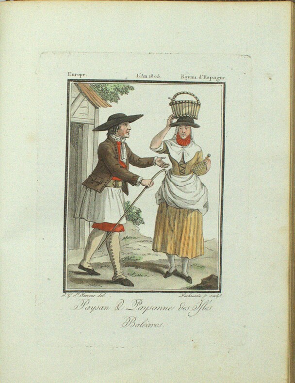
GRASSET DE SAINT-SAUVEUR (Jacques).
Voyages pittoresques dans les quatre parties du monde, ou troisième édition de l’Encyclopédie des voyages, Contenant les Costumes des principaux Peuples de l’Europe. Suivis d’un Précis historiques sur les Mœurs de chaque Peuple. EUROPE seule.
Paris, Madame veuve Hocquart, 1806, petit In-4, basane havane, dos lisse orné de compartiments finement dorés avec pièces de titre, plats ornés d'une frise dorée formant encadrements, dentelle intérieure dorée, tranches dorées. Ex-libris G. Cottereau (Coins frottés, coiffe supérieure abimée, frottements, quelques légères rousseurs.
書籍販売業者の参照番号
: PHO-1913
|
|
|
GRASSI (Ranieri).
[PISE] Il Campanile di Pisa.
[circa 1830]. 203 x 126 mm, 268 x 195 mm avec l'encadrement gouaché.
書籍販売業者の参照番号
: LBW-8415

|
|
|
GRASSI (Ranieri).
[PISE] Il Duomo di Pisa - Le Dôme de Pise.
[circa 1830]. 140 x 202 mm, 198 x 264 mm avec l'encadrement gouaché.
書籍販売業者の参照番号
: LBW-8453

|
|
|
GRASSI (Ranieri).
[PISE] Veduta generale della Piazza del Duomo di Pisa.
[circa 1830]. 139 x 203 mm, 195 x 279 mm avec l'encadrement gouaché.
書籍販売業者の参照番号
: LBW-8454

|
|
|
Grau, J.
Acapulco
No marks or inscriptions. A very clean very tight copy with bright unmarked boards and no bumping to corners. Dust jacket not price clipped or marked or torn with rubbing/nicks to corners. 94pp. A guide to Acapulco in Mexico -- very well illustrated in colour. Scarce in the UK.

|
|
|
Grauert, Hans / Remmert, Reinhold
Theory of Stein Spaces.
Berlin, Heidelberg : Springer (Classics in Mathematics), 2004. XXI, 254 S. (23,5 cm) Broschierte Ausgabe
書籍販売業者の参照番号
: 62366
|
|
|
GRAVIER, Henri.
La Colonisation de la Louisiane à l'époque de Law. Octobre 1717 - Janvier 1721.
Paris, Masson et Cie, éditeurs, 1904. In-8 - 16x24cm. Broché, couverture rempliée. 2ff, IV, 78pp, 2 cartes. Ouvrage rare. Tirage à très petit nombre d'exemplaires. Bien complet de sa grande carte dépliante in fine.
書籍販売業者の参照番号
: 1623

|
|
|
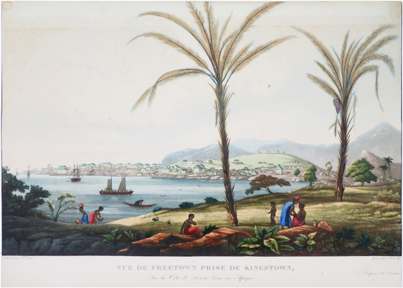
GRAY (James).
[SIERRA LEONE/FREETOWN] Vue de Freetown prise de Kingstown, sur la côte de Sierra Leone en Afrique.
[circa 1830]. 307 x 436 mm.
書籍販売業者の参照番号
: LBW-8071
|
|
|
Gray, Terence.
"AND IN THE TOMB WERE FOUND." Plays and Portraits of Old Egypt. With Illustrations by W. M. Brunton.
pp. xxii, 236 + Frontis and full page drawings and maps by W. M. Brunton. Inked ownership of Mrs. C. F. Klunk, York, Pa. Tall 8vo. Original full green cloth binding, gold lettered. Binding slightly soiled. Hardbound. Includes pieces on: the Kyksos; Dirges; and the Songs in the Tomb of Yntuf the Justified.HOLY LAND BOX 1
|
|
|
Great Britain . Hydrographic Office France. Depot des cartes et plans de la marine Robert Fitzroy Philip Parker King Paul
Instructions nautiques sur les cotes de la Patagonie: depuis la terre des Etats a l'est jusqu . 1863 Leather Bound
2019. Leather Bound. New. Leather Binding on Spine and Corners with Golden Leaf Printing on round Spine. Reprinted in 2019 with the help of original edition published long back 1863. This book is printed in black & white sewing binding for longer life Printed on high quality Paper re-sized as per Current standards professionally processed without changing its contents. As these are old books we processed each page manually and make them readable but in some cases some pages which are blur or missing or black spots. If it is multi volume set then it is only single volume if you wish to order a specific or all the volumes you may contact us. We expect that you will understand our compulsion in these books. We found this book important for the readers who want to know more about our old treasure so we brought it back to the shelves. Hope you will like it and give your comments and suggestions. Lang: - French Pages 334. EXTRA 10 DAYS APART FROM THE NORMAL SHIPPING PERIOD WILL BE REQUIRED FOR LEATHER BOUND BOOKS. FOLIO EDITION IS ALSO AVAILABLE. hardcover
書籍販売業者の参照番号
: LB1111002205884
|
|
|
Great Britain . Hydrographic Office France. Depot des cartes et plans de la marine Robert Fitzroy Philip Parker King Paul
Instructions nautiques sur les cotes de la Patagonie: depuis la terre des Etats a l'est jusqu . 1863
2020. Paperback. New. Lang: - French Pages 334. Reprinted in 2020 with the help of original edition published long back 1863. This book is Printed in black & white sewing binding for longer life with Matt laminated multi-Colour Soft Cover HARDCOVER EDITION IS ALSO AVAILABLE Printed on high quality Paper re-sized as per Current standards professionally processed without changing its contents. As these are old books we processed each page manually and make them readable but in some cases some pages which are blur or missing or black spots. If it is multi volume set then it is only single volume if you wish to order a specific or all the volumes you may contact us. We expect that you will understand our compulsion in these books. We found this book important for the readers who want to know more about our old treasure so we brought it back to the shelves. Any type of Customisation is possible with extra charges. Hope you will like it and give your comments and suggestions. paperback
書籍販売業者の参照番号
: PB1111002205884
|
|
|
Great Britain . Hydrographic Office France. Depot des cartes et plans de la marine Robert Fitzroy Philip Parker King Paul
Instructions nautiques sur les cotes de la Patagonie: depuis la terre des Etats a l'est jusqu . 1863 Hardcover
2020. Hardcover. New. Lang: - French Pages 334. Reprinted in 2020 with the help of original edition published long back 1863. This book is Printed in black & white Hardcover sewing binding for longer life with Matt laminated multi-Colour Dust Cover Printed on high quality Paper re-sized as per Current standards professionally processed without changing its contents. As these are old books we processed each page manually and make them readable but in some cases some pages which are blur or missing or black spots. If it is multi volume set then it is only single volume if you wish to order a specific or all the volumes you may contact us. We expect that you will understand our compulsion in these books. We found this book important for the readers who want to know more about our old treasure so we brought it back to the shelves. Any type of Customisation is possible with extra charges. Hope you will like it and give your comments and suggestions. hardcover
書籍販売業者の参照番号
: 1111002205884
|
|
|
Great Pacific Maps
Great Pacific Olympic Peninsula Washington Recreation Map
Great Pacific Maps 2010-03. Map. Good. Great Pacific Maps unknown
書籍販売業者の参照番号
: SONG0938011839 ISBN : 0938011839 9780938011835
|
|
|
Greene, Patrick (translator)
Looking at Paris
Hardcover in slip-case. Extremely slight foxing to end papers. No other marks or inscriptions. No creasing to covers or to spine. A very clean very tight copy with bright unmarked boards and no bumping to corners. Slip case repaired at lower edge with tape and with bumping to corners. 156pp. Very well illustrated study of the French capital with emphasis on its architecture and art plus its culture, food and the French people.

|
|
|
GREENHILL, Basil & WILLIS, Lionel:
The Coastal Trade. Sailing Craft of British Waters 900-1900. With paintings by Lionel Willis.
London, The Burton Press, 1975, gr. in-4to, 45 plates in color and 53 black & white illustrations, o. clothbound, o. jacket, o. slipcase.
書籍販売業者の参照番号
: 77379aaf
|
|
|
Greenhood, David
Down to Earth: Mapping for Everybody
A clean, unmarked book with a tight binding. 262 pages. Full tan cloth covered boards. 8 5/8"w x 11 1/4"h. Delightful black and white line drawings by Ralph Graeter. Previous owner's name and in pencil and bookstore stamp on front endpaper.

|
|
|
Greepe Thomas; Fold Out Maps Illustrator
The True and Perfecte Newes of the Woorthy and Valiaunt Exploytes Performed and Doone By That Valiant Knight Syr Franics Drake
Henry C. Taylor 1955-01-01. Hardcover. Very Good. NICE CONDITION HARDCOVER BOOK. NO WRITING OR MARKINGS IN TEXT. ONLY LIGHT WEAR TO COVER. A CLEAN SOLID AND LARGE BOOK. Henry C. Taylor hardcover
書籍販売業者の参照番号
: K-1076
|
|
|
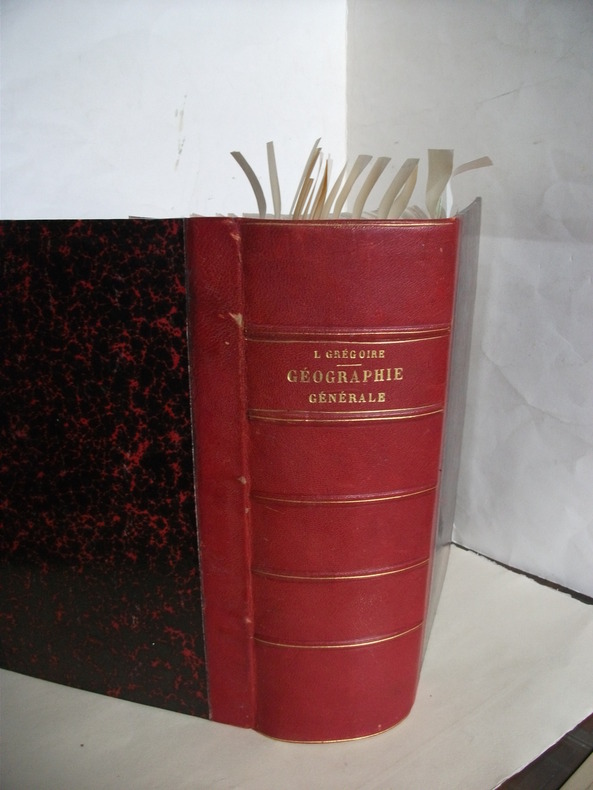
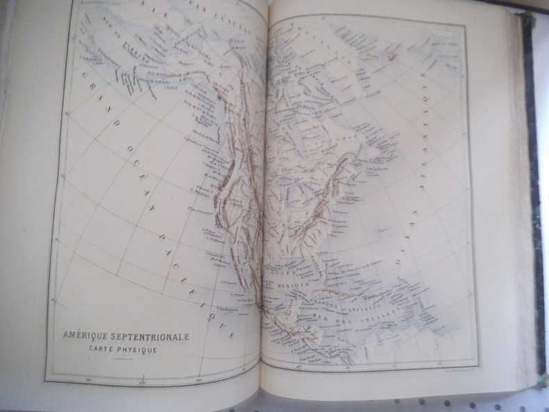
GREGOIRE L.
Géographie générale.
physique,politique et économique,fort in 4 demi-chagrin rouge à nerfs,titre,filets dorés.Faux-titre,frontispice en chromolithographie indien Mandan Etats-Unis,titre avec vignette,1210 pages,16 gravures hors-texte en chromolithographie,20 illustrations hors-texte gravées sur acier, plus de 300 gravures sur bois dans le texte et à pleine page et 100 cartes dans le texte et hors texte en noir et en couleurs.. Garnier frères 1888 quelques rousseurs à certaines pages en début et fin de volume
書籍販売業者の参照番号
: 6687
|
|
|
GREGOIRE L.
GEOGRAPHIE GENERALE, PHYSIQUE, POLITIQUE ET ECONOMIQUE ILLUSTREE .
Paris Garnier fréres 1877, trés fort In-4 relié demi chagrin rouge, dos à nerfs et caissons trés décorés, plats de percaline rouge, toutes tranches dorées, 1206 pages. Avec 100 cartes, certaines en couleurs et dépliantes, de nombreuses gravures intercalées dans le texte, 12 planches de types en chromolithographie couleurs sous serpentes et des gravures sur acier en hors texte. Trés bon exemplaire, complet, bien relié, bel état.
|
|
|
GREGOIRE L.
Géographie générale
Géographie générale Physique, politique et économique, fort in 4 demi-chagrin rouge à nerfs, titre, filets dorés. Faux-titre, frontispice en chromolithographie indien Mandan Etats-Unis, titre avec vignette, 1210 pages, 18 gravures hors-texte en chromolithographie, 20 illustrations hors-texte gravées sur acier, plus de 300 gravures sur bois dans le texte et à pleine page et 100 cartes dans le texte et hors texte en noir et en couleurs.. Garnier frères 1876 quelques rousseurs à certaines pages en début et fin de volume. Un manque angle inférieur droit au premier plat
書籍販売業者の参照番号
: 13316
|
|
|
Gregory M. Franzwa; Illustrator Maps
Maps of the Oregon Trail
Patrice Press 1982. Good. Patrice Press unknown
書籍販売業者の参照番号
: SONG093528432X ISBN : 093528432X 9780935284324
|
|
|
GRELIER Joseph 64 planches hors texte en héliogravure - 8 planches hors texte en couleur - 22 cartes et croquis dans le texte.
Cuba, carrefour des Caraïbes.
Couverture rigide. Cartonnage de l'éditeur. 356 pages. Jaquette défraîchie.
書籍販売業者の参照番号
: 28965
|
|
|
GRENOBLE
Carte allemande couleurs au 1/200 000e.
Une feuille 56x80 cm.
|
|
|
GRENOBLE
Environs de Grenoble. Carte au 1/80 000?, r?vis?e en 1897. Tirage de 1941.
Une feuille 58x55 cm, r?par?e.
|
|
|
GRENOBLE
Grenoble N. E. Carte au 1/50 000?, type 1889, r?vis?e en 1897. Tirage de 1935.
Une feuille 75x53 cm.
|
|
|
GRENOBLE
Grenoble N. O. Carte au 1/50 000?, type 1889 ; r?vis?e en 1932. Tirage de 1936.
Une feuille 75x53 cm.
|
|
|
GRENOBLE
Grenoble S. E. Carte au 1/50 000?, type 1889, r?vis?e en 1897. Tirage de 1934.
Une feuille 75x53 cm.
|
|
|
GRENOBLE
Grenoble S. O. Carte au 1/50 000?, type 1889, r?vis?e en 1932. Tirage de 1941.
Une feuille 75x53 cm.
|
|
|
GREVIN Emmanuel.
voyage au Hoggar.Tourisme au Sahara.
Stock 1936 In-8 Broché, couverture illustrée Dédicacé par l'auteur
書籍販売業者の参照番号
: 013160
|
|
|
Grey Eve Illustrated by Tambi Larsen Maps by Charles A. Williams Journalist 3rd class USN
Legends of Micronesia Book Two
High Commissioner Trust Territor 1951-01-01. Hardcover. Good. . High Commissioner Trust Territor hardcover
書籍販売業者の参照番号
: mon0001368995
|
|
|
GREY Eve. Text by. Illustrations by Tambi Lardsen. Maps by Charles A. Williams.
Legends of Micronesia. Book Two. Micronesian Reader Series.
Department of Education Pacific Islands. 1951. First Edition. Paperback staple binding. 4to. Illustrated. Spine slightly worn and covers a little shelf worn. Contents clean and sound. 1951 paperback
書籍販売業者の参照番号
: 82133
|
|
|
Grierson, E.
Things Seen in Edinburgh
Lengthy inscription on reverse of frontis. No other marks. A very clean very tight copy with bright unmarked boards, slightly sunned spine, dusty/foxed page edges and no bumping to corners. Dust jacket not price clipped with small pieces missing, nicks, chips and small tears to edges and sunned spine. 157pp. Illustrated account of what to see on a visit to Edinburgh.

|
|
|
GRIFFIN (Frederick).
[IRLANDE du NORD] Northern Ireland. Ulster.
Londres, The British Travel and Holidays Association, 1955. 904 x 550 mm ; monté sur toile.
書籍販売業者の参照番号
: LBW-8598

|
|
|
GRIFFIN (Frederick).
Scotland.
The Scottish Tourist Board, [circa 1960]. 972 x 587 mm.
書籍販売業者の参照番号
: LBW-8438

|
|
|
Griffith II Samuel B./Carnes John maps
The Battle for Guadalcanal Great Battles of History Series
Philadelphia: J.B. Lippincott 1963. 1st printing. VG/Good dust jacket creasing/short tears to dust jacket name on front endpaper. xxii 282 p. maps notes small 8vo;; J.B. Lippincott hardcover
書籍販売業者の参照番号
: 50383

|
|
|
Griffith, John
Charte von Klein-Asien für die Reise von Griffith. Routenkolorierte Kupferstich-Karte.
[Leipzig, J. H. Hinrichs, 1814]. 26 x 36 cm. Unter Passepartout.
書籍販売業者の参照番号
: 78823

|
|
|
Griffith, John
Charte von Syrien, Mesopotamine, und einem Theile von Persien. neu entworfen von J. Griffith. Grenzkolorierte Kupferstich-Karte.
[Leipzig, J. H. Hinrichs, 1814]. 26 x 37 cm. Unter Passepartout.
書籍販売業者の参照番号
: 78822

|
|
|
Grimm, Maximilian von.
Grundriss der k. k. Haupt- und Residenzstadt Wien mit ihren Vorstädten nach den neuen Hausnummern. Plan de la Ville de Vienne et de ses Fauxbourgs [...]. Wien, Artaria und Comp., 1797.
1373 x 1388 mm. Kolorierte Kupferstichkarte. 48 Segmente auf Leinen aufgezogen. Mit figürlicher Kartusche von Hieronymus Benedicti nach Grimm. In marmoriertem Schuber der Zeit mit blindgepr. Titelschild ("Plan de la Ville de Vienne et de ses Fauxbourgs") sowie einem handschriftlichen Rückenschildchen ("Plan de Vienne 1797"). Erste Auflage des sog. Grimm-Plans von Wien und Umgebung, mit den Hausnummern der 2. Häusernumerierung 1795, der den veralteten Nagel-Plan von 1780/81 ersetzte. "Ausgezeichnet ausgeführt" (Dörflinger). Grimm verkleinerte Nagels Plan um das anderthalbfache und brachte ihn auf den neuesten Stand; "das abgebildete Gebiet deckt sich fast zur Gänze mit dem der Vorlage, auch die Darstellungsweise ist nahezu identisch - lediglich die Orientierung wurde um 180° gedreht (nordost- statt südwestorientiert [...] Blatt VI enthält in tabellarischer Form ein alphabetisch geordnetes 'Verzeichniss der K. Kön. und Aerarial Gebäude', der fürstlichen, gräflichen und geistlichen Häuser, der 'Kirchen und Pfarren', der 'Academien, Schulen, Spitäler' und der 'Sehenswürdigkeiten für Fremde' sowie ein 'Register der Plätze, Straßen und Gassen'" (ebda.). - Der Schuber an den Ecken etwas berieben; die Karte wohlerhalten. Dörflinger S. 297, Art 24. Austria Picta 108.
|
|
|
GRIWTONN (P.L.).
[SAINT-DOMINGUE] Carte de l'isle de S.t Domingue avec les routes.
Paris, Charles Dien, An X - 1801. 433 x 640 mm.
書籍販売業者の参照番号
: LBW-8200

|
|
|
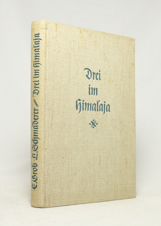
GROB Ernst; SCHMADERER Ludwig:
Drei im Himalaja.
München, Verlag F. Bruckmann, 1938. In-8 de 97 pages, pleine toile grège.
書籍販売業者の参照番号
: 16735
|
|
|
GROB, Richard:
Geschichte der schweizerischen Kartographie.
Bern, Kümmerly & Frey, 1941, in-8°, 195 S. + XXVIII (Kartographische Tafeln, 31 Fig.), Original-Broschüre.
書籍販売業者の参照番号
: 126363aaf
|
|
|
Grolier Society; Glossy Color Photos Maps Illustrator
Lands & Peoples. the World in Color. Volume 1. British Isles & Western Europe Vol One I Hardcover Jan 01 1961 Grolier Society; Glossy Color Photos Maps Illustrator
Grolier Inc 1961-01-01. Hardcover. Like New. Edition: 1st thus; Like New HC no DJ embossed boards 1961 ed Volume 1 Only no page wear unmarked minor rub top spine end only Grolier Inc hardcover
書籍販売業者の参照番号
: B1965ED
|
|
|
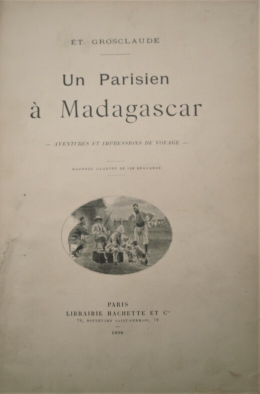
GROSCLAUDE , Étienne
Un parisien à Madagascar - Aventures et impressions de voyage
Paris, Librairie Hachette et Cie, 1898. In-4 relié demi-basane blanche de l'époque , dos lisse orné avec auteur , titre et date en pied , XVI + 368 pages. Ouvrage illustré de 138 gravures. 1 carte dépliante en couleurs( brunie partiellement) , avec une dédicace de l’auteur .
書籍販売業者の参照番号
: PHO-1066
|
|
|
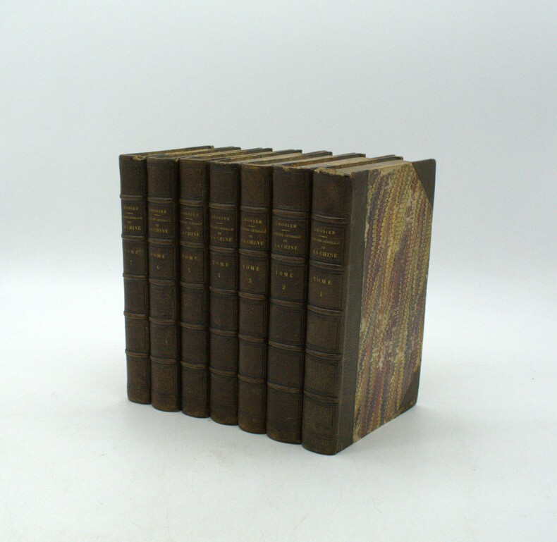
GROSIER (Jean-Baptiste Gabriel Alexandre).
De la Chine, ou description générale de cet Empire, rédigée d’après les Mémoires de la Mission de Pékin. Ouvrage qui contient la description topographique des quinze provinces de la Chine, celle de la Tartarie, des îles… le tableau de sa population… et l’exposé de toutes les connaissances acquises et parvenues jusqu’ici en Europe sur le gouvernement, la religion, les lois, les mœurs, les usages, les sciences et les arts des Chinois.
Paris, chez Pillet, 1818-1820. 7 vol. in-8, demi-maroquin brun à coins, papiers de plats, tranches et gardes peignés, dos à nerfs, petits défauts dont plusieurs coiffes de tête frottées et des coins émoussés, plats frottés, rousseurs, brunissures.
書籍販売業者の参照番号
: PHO-1944
|
|
|
GROSJEAN, Georges / KINAUER, Rudolf:
Kartenkunst und Kartentechnik vom Altertum bis zum Barock.
Bern; Hallwag, 1970, in-4to, 143 S. mit zahlr. Kartenabb. Original-Leinenband. Ill. Orig.-Umschlag.
書籍販売業者の参照番号
: 129542aaf
|
|
|
Gross Alexander
GEOGRAPHERS' STANDARD MAP OF ENGLAND AND WALES
London: Geographers' Map Co Ltd. No date. Circa 1950. Very large colour linen-backed map approximately 102 x 136cm dissected into 25 sections folding into green cloth-backed boards. In very good condiion boards with a little wear to spine map very good map excellent clean paper slightly toned. Bookplate of The Iron and Steel Institute The Institute of Metals to inside front board - dated Jan 1953 - cost of map �1 15s single stamp of the same to the rear of the map. A very good copy of this excellent map. Very Good. Geographers' Map Co Ltd. hardcover
書籍販売業者の参照番号
: 006594
|
|
|
GROSS, A.G. FREIHERRN von.
Historisch-militärisches Handbuch für die Kriegsgeschichte der Jahre 1792 bis 1808, enthaltend eine genaue Uebersicht aller Feldzüge und Landungen, welche in diesem Zeitraume Statt gefunden haben. Mit einem topographisch-militairischen Atlasses von 17...
Amsterdam, Kunst- und Industrie - Comptoir, 1808. 8vo. and folio. Textvol. bound in modest hcalf., spine worn. Atlas-volume in contemp. boards with printed title from orig frontwrapper pasted on frontboard, and later clothbacking. Corners bumped. Stamps on titlepage and old owners name. First and last leaves a little brownspotted, scattered brownspots. Atlas-volume with titlepage on which content of maps. 17 large folded engraved maps, mostly folded and in double-folio, with outline and position colouring. Maps uncut and clean.
|
|
|
GROSS, A.G. FREIHERRN von.
Historisch-militärisches Handbuch für die Kriegsgeschichte der Jahre 1792 bis 1808, enthaltend eine genaue Uebersicht aller Feldzüge und Landungen, welche in diesem Zeitraume Statt gefunden haben. Mit einem topographisch-militairischen Atlasses von 17...
Amsterdam, Kunst- und Industrie - Comptoir, 1808. 8vo. and folio. Textvol. bound in modest hcalf., spine worn. Atlas-volume in contemp. boards with printed title from orig frontwrapper pasted on frontboard, and later clothbacking. Corners bumped. Stamps on titlepage and old owners name. First and last leaves a little brownspotted, scattered brownspots. Atlas-volume with titlepage on which content of maps. 17 large folded engraved maps, mostly folded and in double-folio, with outline and position colouring. Maps uncut and clean.
書籍販売業者の参照番号
: 40611
|
|
|
Gross, Alexander
The Authentic Map of London : With Index of Streets and Place of Interest
Undated, with a special underground railway map on the back cover. eng
|
|
|
Gross-Jaegerndorf:
Gross-Jaegerndorf in Preussen. "Plan der bey Gross-Jaegerndorf in Preussen den 30.Augusti A.1757 zwischen denen Kayserl. Russischen u. Königl. Preussischen Armeen vorgefallenen Bataille". Schlachtenplan von Gross-Jaegerndorf. Kupferstich mit farbigen Truppenaufstellungen aus "Neues Kriegs-Theater ...", No. 10.
Format: 18 x 29,5 cm. *Leicht gebräunt, insgesamt gut erhalten. Landkarten de
|
|
 検索結果のメールを受信する
 PDFファイルの検索結果をダウンロード
 RSSフィード


