|
Greene, Patrick (translator)
Looking at Paris
Hardcover in slip-case. Extremely slight foxing to end papers. No other marks or inscriptions. No creasing to covers or to spine. A very clean very tight copy with bright unmarked boards and no bumping to corners. Slip case repaired at lower edge with tape and with bumping to corners. 156pp. Very well illustrated study of the French capital with emphasis on its architecture and art plus its culture, food and the French people.

|
|
|
Greenhood, David
Down to Earth: Mapping for Everybody
A clean, unmarked book with a tight binding. 262 pages. Full tan cloth covered boards. 8 5/8"w x 11 1/4"h. Delightful black and white line drawings by Ralph Graeter. Previous owner's name and in pencil and bookstore stamp on front endpaper.

|
|
|
Greepe Thomas; Fold Out Maps Illustrator
The True and Perfecte Newes of the Woorthy and Valiaunt Exploytes Performed and Doone By That Valiant Knight Syr Franics Drake
Henry C. Taylor 1955-01-01. Hardcover. Very Good. NICE CONDITION HARDCOVER BOOK. NO WRITING OR MARKINGS IN TEXT. ONLY LIGHT WEAR TO COVER. A CLEAN SOLID AND LARGE BOOK. Henry C. Taylor hardcover
书商的参考编号 : K-1076
|
|
|
GREGOIRE L.
GEOGRAPHIE GENERALE, PHYSIQUE, POLITIQUE ET ECONOMIQUE ILLUSTREE .
Paris Garnier fréres 1877, trés fort In-4 relié demi chagrin rouge, dos à nerfs et caissons trés décorés, plats de percaline rouge, toutes tranches dorées, 1206 pages. Avec 100 cartes, certaines en couleurs et dépliantes, de nombreuses gravures intercalées dans le texte, 12 planches de types en chromolithographie couleurs sous serpentes et des gravures sur acier en hors texte. Trés bon exemplaire, complet, bien relié, bel état.
|
|
|
Gregory M. Franzwa; Illustrator Maps
Maps of the Oregon Trail
Patrice Press 1982. Good. Patrice Press unknown
书商的参考编号 : SONG093528432X ???????? : 093528432X 9780935284324
|
|
|
GRENOBLE
Carte allemande couleurs au 1/200 000e.
Une feuille 56x80 cm.
|
|
|
GRENOBLE
Environs de Grenoble. Carte au 1/80 000?, r?vis?e en 1897. Tirage de 1941.
Une feuille 58x55 cm, r?par?e.
|
|
|
GRENOBLE
Grenoble N. E. Carte au 1/50 000?, type 1889, r?vis?e en 1897. Tirage de 1935.
Une feuille 75x53 cm.
|
|
|
GRENOBLE
Grenoble N. O. Carte au 1/50 000?, type 1889 ; r?vis?e en 1932. Tirage de 1936.
Une feuille 75x53 cm.
|
|
|
GRENOBLE
Grenoble S. E. Carte au 1/50 000?, type 1889, r?vis?e en 1897. Tirage de 1934.
Une feuille 75x53 cm.
|
|
|
GRENOBLE
Grenoble S. O. Carte au 1/50 000?, type 1889, r?vis?e en 1932. Tirage de 1941.
Une feuille 75x53 cm.
|
|
|
Grey Eve Illustrated by Tambi Larsen Maps by Charles A. Williams Journalist 3rd class USN
Legends of Micronesia Book Two
High Commissioner Trust Territor 1951-01-01. Hardcover. Good. . High Commissioner Trust Territor hardcover
书商的参考编号 : mon0001368995
|
|
|
GREY Eve. Text by. Illustrations by Tambi Lardsen. Maps by Charles A. Williams.
Legends of Micronesia. Book Two. Micronesian Reader Series.
Department of Education Pacific Islands. 1951. First Edition. Paperback staple binding. 4to. Illustrated. Spine slightly worn and covers a little shelf worn. Contents clean and sound. 1951 paperback
书商的参考编号 : 82133
|
|
|
GRIFFIN (Frederick).
[IRLANDE du NORD] Northern Ireland. Ulster.
Londres, The British Travel and Holidays Association, 1955. 904 x 550 mm ; monté sur toile.
书商的参考编号 : LBW-8598

|
|
|
GRIWTONN (P.L.).
[SAINT-DOMINGUE] Carte de l'isle de S.t Domingue avec les routes.
Paris, Charles Dien, An X - 1801. 433 x 640 mm.
书商的参考编号 : LBW-8200

|
|
|
GRIFFIN (Frederick).
Scotland.
The Scottish Tourist Board, [circa 1960]. 972 x 587 mm.
书商的参考编号 : LBW-8438

|
|
|
Grierson, E.
Things Seen in Edinburgh
Lengthy inscription on reverse of frontis. No other marks. A very clean very tight copy with bright unmarked boards, slightly sunned spine, dusty/foxed page edges and no bumping to corners. Dust jacket not price clipped with small pieces missing, nicks, chips and small tears to edges and sunned spine. 157pp. Illustrated account of what to see on a visit to Edinburgh.

|
|
|
Griffith II Samuel B./Carnes John maps
The Battle for Guadalcanal Great Battles of History Series
Philadelphia: J.B. Lippincott 1963. 1st printing. VG/Good dust jacket creasing/short tears to dust jacket name on front endpaper. xxii 282 p. maps notes small 8vo;; J.B. Lippincott hardcover
书商的参考编号 : 50383

|
|
|
Griffith, John
Charte von Klein-Asien für die Reise von Griffith. Routenkolorierte Kupferstich-Karte.
[Leipzig, J. H. Hinrichs, 1814]. 26 x 36 cm. Unter Passepartout.
书商的参考编号 : 78823

|
|
|
Griffith, John
Charte von Syrien, Mesopotamine, und einem Theile von Persien. neu entworfen von J. Griffith. Grenzkolorierte Kupferstich-Karte.
[Leipzig, J. H. Hinrichs, 1814]. 26 x 37 cm. Unter Passepartout.
书商的参考编号 : 78822

|
|
|
Grimm, Maximilian von.
Grundriss der k. k. Haupt- und Residenzstadt Wien mit ihren Vorstädten nach den neuen Hausnummern. Plan de la Ville de Vienne et de ses Fauxbourgs [...]. Wien, Artaria und Comp., 1797.
1373 x 1388 mm. Kolorierte Kupferstichkarte. 48 Segmente auf Leinen aufgezogen. Mit figürlicher Kartusche von Hieronymus Benedicti nach Grimm. In marmoriertem Schuber der Zeit mit blindgepr. Titelschild ("Plan de la Ville de Vienne et de ses Fauxbourgs") sowie einem handschriftlichen Rückenschildchen ("Plan de Vienne 1797"). Erste Auflage des sog. Grimm-Plans von Wien und Umgebung, mit den Hausnummern der 2. Häusernumerierung 1795, der den veralteten Nagel-Plan von 1780/81 ersetzte. "Ausgezeichnet ausgeführt" (Dörflinger). Grimm verkleinerte Nagels Plan um das anderthalbfache und brachte ihn auf den neuesten Stand; "das abgebildete Gebiet deckt sich fast zur Gänze mit dem der Vorlage, auch die Darstellungsweise ist nahezu identisch - lediglich die Orientierung wurde um 180° gedreht (nordost- statt südwestorientiert [...] Blatt VI enthält in tabellarischer Form ein alphabetisch geordnetes 'Verzeichniss der K. Kön. und Aerarial Gebäude', der fürstlichen, gräflichen und geistlichen Häuser, der 'Kirchen und Pfarren', der 'Academien, Schulen, Spitäler' und der 'Sehenswürdigkeiten für Fremde' sowie ein 'Register der Plätze, Straßen und Gassen'" (ebda.). - Der Schuber an den Ecken etwas berieben; die Karte wohlerhalten. Dörflinger S. 297, Art 24. Austria Picta 108.
|
|
|
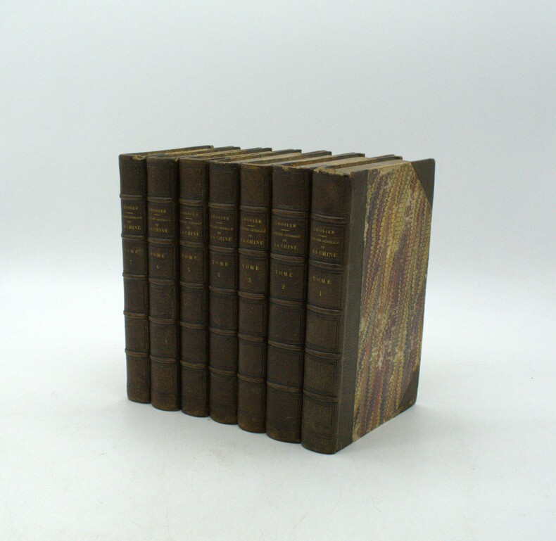
GROSIER (Jean-Baptiste Gabriel Alexandre).
De la Chine, ou description générale de cet Empire, rédigée d’après les Mémoires de la Mission de Pékin. Ouvrage qui contient la description topographique des quinze provinces de la Chine, celle de la Tartarie, des îles… le tableau de sa population… et l’exposé de toutes les connaissances acquises et parvenues jusqu’ici en Europe sur le gouvernement, la religion, les lois, les mœurs, les usages, les sciences et les arts des Chinois.
Paris, chez Pillet, 1818-1820. 7 vol. in-8, demi-maroquin brun à coins, papiers de plats, tranches et gardes peignés, dos à nerfs, petits défauts dont plusieurs coiffes de tête frottées et des coins émoussés, plats frottés, rousseurs, brunissures.
书商的参考编号 : PHO-1944
|
|
|
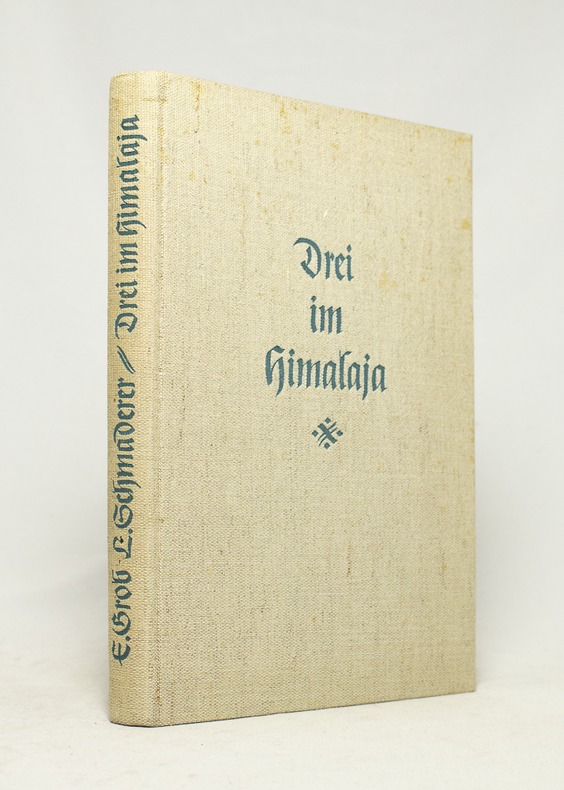
GROB Ernst; SCHMADERER Ludwig:
Drei im Himalaja.
München, Verlag F. Bruckmann, 1938. In-8 de 97 pages, pleine toile grège.
书商的参考编号 : 16735
|
|
|
GROB, Richard:
Geschichte der schweizerischen Kartographie.
Bern, Kümmerly & Frey, 1941, in-8°, 195 S. + XXVIII (Kartographische Tafeln, 31 Fig.), Original-Broschüre.
书商的参考编号 : 126363aaf
|
|
|
GROSS, A.G. FREIHERRN von.
Historisch-militärisches Handbuch für die Kriegsgeschichte der Jahre 1792 bis 1808, enthaltend eine genaue Uebersicht aller Feldzüge und Landungen, welche in diesem Zeitraume Statt gefunden haben. Mit einem topographisch-militairischen Atlasses von 17...
Amsterdam, Kunst- und Industrie - Comptoir, 1808. 8vo. and folio. Textvol. bound in modest hcalf., spine worn. Atlas-volume in contemp. boards with printed title from orig frontwrapper pasted on frontboard, and later clothbacking. Corners bumped. Stamps on titlepage and old owners name. First and last leaves a little brownspotted, scattered brownspots. Atlas-volume with titlepage on which content of maps. 17 large folded engraved maps, mostly folded and in double-folio, with outline and position colouring. Maps uncut and clean.
书商的参考编号 : 40611
|
|
|
GROSJEAN, Georges / KINAUER, Rudolf:
Kartenkunst und Kartentechnik vom Altertum bis zum Barock.
Bern; Hallwag, 1970, in-4to, 143 S. mit zahlr. Kartenabb. Original-Leinenband. Ill. Orig.-Umschlag.
书商的参考编号 : 129542aaf
|
|
|
GROUSSET, René
L'Empire du Levant. Histoire de la question d'Orient. Avec vingt et une cartes
1979 1 Editions Payot, Collection "Bibliothèque Historique" - 1992 - In-8 broché - 648 pages
书商的参考编号 : 77551
|
|
|
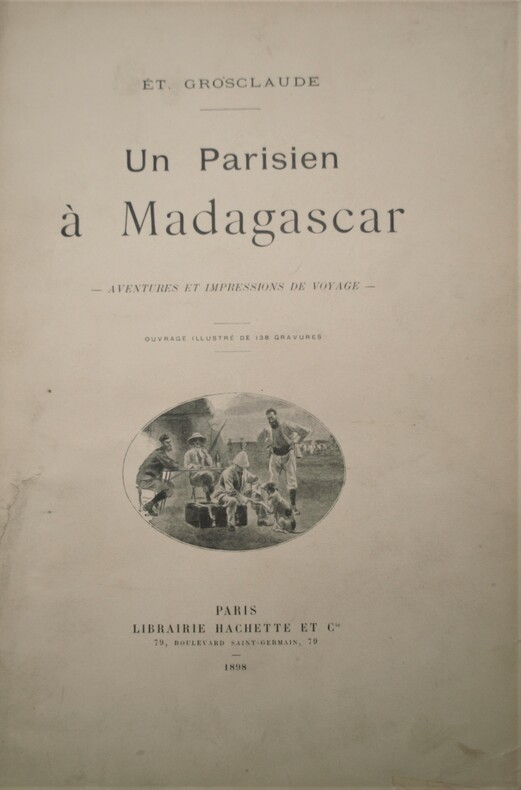
GROSCLAUDE , Étienne
Un parisien à Madagascar - Aventures et impressions de voyage
Paris, Librairie Hachette et Cie, 1898. In-4 relié demi-basane blanche de l'époque , dos lisse orné avec auteur , titre et date en pied , XVI + 368 pages. Ouvrage illustré de 138 gravures. 1 carte dépliante en couleurs( brunie partiellement) , avec une dédicace de l’auteur .
书商的参考编号 : PHO-1066
|
|
|
Grolier Society; Glossy Color Photos Maps Illustrator
Lands & Peoples. the World in Color. Volume 1. British Isles & Western Europe Vol One I Hardcover Jan 01 1961 Grolier Society; Glossy Color Photos Maps Illustrator
Grolier Inc 1961-01-01. Hardcover. Like New. Edition: 1st thus; Like New HC no DJ embossed boards 1961 ed Volume 1 Only no page wear unmarked minor rub top spine end only Grolier Inc hardcover
书商的参考编号 : B1965ED
|
|
|
Gross Alexander
GEOGRAPHERS' STANDARD MAP OF ENGLAND AND WALES
London: Geographers' Map Co Ltd. No date. Circa 1950. Very large colour linen-backed map approximately 102 x 136cm dissected into 25 sections folding into green cloth-backed boards. In very good condiion boards with a little wear to spine map very good map excellent clean paper slightly toned. Bookplate of The Iron and Steel Institute The Institute of Metals to inside front board - dated Jan 1953 - cost of map �1 15s single stamp of the same to the rear of the map. A very good copy of this excellent map. Very Good. Geographers' Map Co Ltd. hardcover
书商的参考编号 : 006594
|
|
|
GROSS, A.G. FREIHERRN von.
Historisch-militärisches Handbuch für die Kriegsgeschichte der Jahre 1792 bis 1808, enthaltend eine genaue Uebersicht aller Feldzüge und Landungen, welche in diesem Zeitraume Statt gefunden haben. Mit einem topographisch-militairischen Atlasses von 17...
Amsterdam, Kunst- und Industrie - Comptoir, 1808. 8vo. and folio. Textvol. bound in modest hcalf., spine worn. Atlas-volume in contemp. boards with printed title from orig frontwrapper pasted on frontboard, and later clothbacking. Corners bumped. Stamps on titlepage and old owners name. First and last leaves a little brownspotted, scattered brownspots. Atlas-volume with titlepage on which content of maps. 17 large folded engraved maps, mostly folded and in double-folio, with outline and position colouring. Maps uncut and clean.
|
|
|
Gross, Alexander
The Authentic Map of London : With Index of Streets and Place of Interest
Undated, with a special underground railway map on the back cover. eng
|
|
|
Gross-Jaegerndorf:
Gross-Jaegerndorf in Preussen. "Plan der bey Gross-Jaegerndorf in Preussen den 30.Augusti A.1757 zwischen denen Kayserl. Russischen u. Königl. Preussischen Armeen vorgefallenen Bataille". Schlachtenplan von Gross-Jaegerndorf. Kupferstich mit farbigen Truppenaufstellungen aus "Neues Kriegs-Theater ...", No. 10.
Format: 18 x 29,5 cm. *Leicht gebräunt, insgesamt gut erhalten. Landkarten de
|
|
|
Grove Noel
National Geographic Atlas Of World History
<p>Sewn binding. Cloth over boards. Contains: Illustrations. Audience: General/trade.</p> National Geographic hardcover
书商的参考编号 : biblio878 ???????? : 0792270487 9780792270485

|
|
|
Groß-Jägerndorf:
Groß-Jägerndorf. "Plan der Bataille welche d. 30. Aug. 1757 von der Kayserl. Russischen und Königl. Preussischen Armee bei Groß-Jägerndorf in Preussen geliefert worden". Schlachtenplan von Groß-Jägerndorf. Kupferstich mit farbigen Truppenaufstellungen aus "Neues Kriegs-Theater ...", 2. Supplement.
Format: 18 x 29,5 cm. *Leicht gebräunt, insgesamt gut erhalten. Landkarten de
|
|
|
Groß-Jägerndorf:
Groß-Jägerndorf. "Plan der bey Gross-Jägerndorf, den 30 Augusti A.1757 zwischen denen Kaiserl. Russischen und Königl. Preussischen Armeen vorgefallenen Bataille". Schlachtenplan von Groß-Jägerndorf . Kupferstich mit farbigen Truppenaufstellungen aus: "Die Geschichte des jetzigen Kriegs zu unparteyischer Erkenntniß seines Anfangs ..."
Format: 18,5 x 30 cm. *Leicht gebräunt, am unteren Blattrand mit unterlegter Fehlstelle. Insgesamt gut erhalten. Landkarten de
|
|
|
GRUNER Gottlieb Sigmund:
Histoire naturelle des glacières de la Suisse. Traduction libre de l'allemand de M. Grouner par M. de Kéralio.
Paris, Panckoucke, 1770. In-4 de XIV-[2]- XIV-372 pages, demi-veau brun, dos à nerfs orné de filets dorés, pièce de titre en maroquin rouge, tranches rouges. Reliure pastiche XXème.
书商的参考编号 : 18491
|
|
|
Grylls Bear Collins Maps
Extreme Survivors
HarperCollins UK. Used - Good. Ships from the UK. Former Library book. Shows some signs of wear and may have some markings on the inside. 100% Money Back Guarantee. Your purchase also supports literacy charities. HarperCollins UK unknown
书商的参考编号 : GRP74862456 ???????? : 0007482779 9780007482771

|
|
|
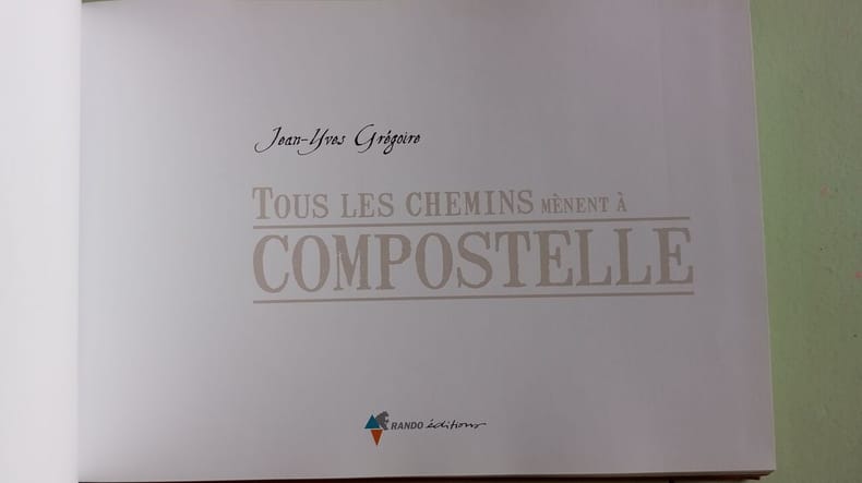
Grégoire Jean-Yves
Tous les chemins mènent à Compostelle
Rando Editions 2007 254 pages 24 6x2x17 4cm. 2007. Broché. 254 pages.
书商的参考编号 : 500196802
|
|
|
Gróf, László L
Ortelius' Maps of Hungary.
Tring, Herfordshire, Map Collector Publ. Ltd, 1979. 30 x 21 cm. 10 (num. 2-11) S. mit zahlr. Abb. Illustrierter Originalkarton (Softcover). Schönes gepflegtes Exemplar. In: The Map Collector ; #6, March 1979.
书商的参考编号 : 16775AB

|
|
|
Guadalupi Gianni and Manguel Alberto Illustrated by Graham Greenfield Maps and Charts by James Cook
The Dictionary of Imaginary Places
New York: Macmillan Publishing Co 1980. First Edition First Printing. Hardcover. Quarto; VG/VG; illustrated spine with white text; jacket has some rubbing and scuffing minor spotting on verso side fold in upper corner of front flap; boards are strong spine slightly cocked; textblock has spotting on head and fore edges otherwise clean; pp 438. Full-priced Rockville. <br/><br/> Macmillan Publishing Co hardcover
书商的参考编号 : 14-436-1293597 ???????? : 0025793101 9780025793101
|
|
|
Guadalupi Gianni and Manguel Alberto Illustrated by Graham Greenfield Maps and Charts by James Cook
The Dictionary of Imaginary Places
New York: Macmillan Publishing Co 1980. First Edition First Printing. Hardcover. Quarto; VG/VG; illustrated spine with white text; jacket has some rubbing and scuffing minor spotting on verso side fold in upper corner of front flap; boards are strong spine slightly cocked; textblock has spotting on head and fore edges otherwise clean; pp 438. 1293597. Full-priced Rockville. Macmillan Publishing Co hardcover books
书商的参考编号 : 1293597 ???????? : 0025793101 9780025793101
|
|
|
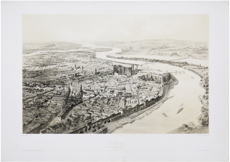
GUESDON (Alfred).
[AVIGNON] Avignon. Vue prise du Quai au Bois.
Paris, A. Hauser, [1847]. 333 x 438 mm.
书商的参考编号 : LBW-7199
|
|
|
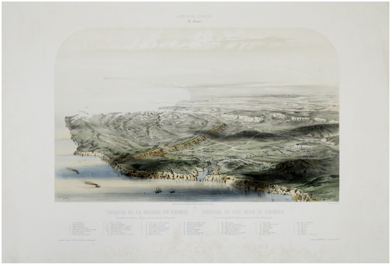
GUESDON (Alfred).
[CRIMÉE/SÉBASTOPOL] Théâtre de la guerre en Crimée. Position des Armées Alliées et Russes devant Sébastopol - Theatre of the war in Crimea. Position of the Allied and Russian Armies before Sevastopol.
Paris, Wild, [circa 1860]. 457 x 562 mm.
书商的参考编号 : LBW-6009
|
|
|
GUESDON (Alfred).
Carcassonne. Vue prise au dessus du Canal du Midi.
Paris, Hauser, Carcassonne, Combélérant, [1848]. 329 x 440 mm.
书商的参考编号 : LBW-6677

|
|
|
GUESDON (Alfred).
Dijon. Vue prise au dessus du cours du Parc.
Paris, A. Hauser, [circa 1840]. 318 x 434 mm.
书商的参考编号 : LBW-571
|
|
|
GUENO, Jean - Pierre et LAPLUME, Yves;
PAROLES DE POILUS. LETTRES DE LA GRANDE GUERRE,
, s.l., France Loisirs, 1998, relie en maroquin noir sous jacquette d'editeur illustree, plattes interieures decorees, 250 x 290mm., 144pp., tres nombreuses illustrations (cartes postales et photos d'epoque ainsi que reproductions de courriers manuscrits en fac-simile) en noir et en couleurs.
书商的参考编号 : 15031
|
|
|
Guernsey, Egbert.
HISTORY OF THE UNITED STATES OF AMERICA, DESIGNED FOR SCHOOLS. Extending From the Discovery of America by Columbus to the Present Time; with Numerous Maps and Engravings, Together With a Notice of American Antiquities, and the Indian Tribes. Fifth Edition
456p. + Engraved Half Title and three full page color maps. Text maps and woodcut engravings. Age stained. Some damp staining. Lacks first and last endpapers. Questions printed in margins. 12mo. Original leather spine over pictorial paper covered boards. Spine gold lettered and embossed in blind. Boards stained. Extremities worn with loss. Hardbound. PA71 FRONT
|
|
|
GUESDON Alfred (Nantes 1808 - ?)
Rome Vue prise au dessus de la Place Colonne
Alfred Guesdon nasce a Nantes il 13 giugno del 1808, terminati gli studi classici parte nel 1829 alla volta di Parigi per entrare come allievo architetto nello studio di Antoine Martin Garnaud. Dal 1830 si dedicò a sperimentazioni e ricerche nel campo della litografia, prediligendo soggetti storici, vedute e panorami, tratti dai numerosi viaggi che egli fece in Europa. La peculiarità di queste vedute sta nel fatto che si tratta dei primi rilievi di città dall’alto, effettuati a bordo di una mongolfiera. Nel 1849 pubblica le tavole, in litografia, nel celebre L’Italie à vol d’oiseau., o storia e descrizione sommaria delle principali città di questo paese, di H. Etiennez, accompagnate da 40 grandi vedute generali, disegnate dal vero da Alfred Guesdon e litografate con due tinte da A. Rouargue, Jules Arnout, A. Cuvillier, A. Guesdon. Litografia tinta, finemente colorata a mano, in perfetto stato di conservazione. Alfred Guesdon was born in Nantes, June the 13th 1808. Once he finished his classical studies, in 1829, he went to Paris, to study architecture as a pupil of Antoine Martin Garnaud. Starting from 1830, he devoted himself to experimentations and researches on the art of lithography, especially on historical subjects, views and landscapes he took from his many trips around Europe. The distinctiveness of these views is the fact that they are the first representations of the cities from above, realized on board of an air balloon. In 1849 he published the lithographic plates in the famous L’Italie à vol d’oiseau., o storia e descrizione sommaria delle principali città di questo paese, di H. Etiennez, accompagnate da 40 grandi vedute generali, disegnate dal vero da Alfred Guesdon e litografate con due tinte da A. Rouargue, Jules Arnout, A. Cuvillier, A. Guesdon. Tinted litograph with later hand colour, very good condition. Bibliografia: D. Straffolino, Alfred Guesdon, L'Italie a vol d'oiseau (1849). La veduta a volo d'uccello dalle ali di Icaro alla mongolfiera; Cremonini, L’Italia nelle vedute e crate geografiche, pp. 241/242.

|
|
|
GUESDON Alfred (Nantes 1808 - ?)
Rome Vue prise au dessus du Mont-Celio
Splendida veduta a volo d’uccello, realizzata in litografia, e pubblicata nel celebre L’Italie à vol d’oiseau., o storia e descrizione sommaria delle principali città di questo paese, di H. Etiennez, accompagnate da 40 grandi vedute generali, disegnate dal vero da Alfred Guesdon e litografate con due tinte da A. Rouargue, Jules Arnout, A. Cuvillier, A. Guesdon. Nato nel 1808 a Nantes, Guesdon intraprende senza fortuna la carriera di architetto e decide di dedicarsi al vedutismo anche con l’ausilio del pallone aerostatico in taluni casi e delle foto che ne trae. Per quindici anni l' artistaviaggiatore percorre interamente quella parte d' Europa che va «dal golfo di Napoli alle rive del Reno, dal lago di Ginevra allo stretto di Gibilterra». Per quanto riguarda la produzione iconografica, Guesdon realizza vedute di città italiane, francesi, spagnole e svizzere. A partire dal 1849 vengono pubblicate nell' ordine: L' Italie à vol d' oiseau, o storia e descrizione sommaria delle principali città di questo paese, di H. Etiennez, accompagnate da 40 grandi vedute generali, disegnate dal vero e litografate con due tinte Parigi, Hauser, 1849, volume in-folio. I disegni originari furono realizzati prima del 1848 e rappresentano le città italiane: da Torino a Genova, da Milano a Venezia, da Firenze a Roma, fino a Napoli, Pompei, Palermo, Messina e Catania. Pubblica poi La France a vol d' oiseau. Viaggio aereo sulla Loira e le sue rive, con la rappresentazione di 37 città; infine nel 1853 pubblica L' Espagne à vol d' oiseau con 24 vedute generali delle principali città del paese. Assai meno nota la raccolta di città svizzere dal titolo: La Suisse à vol d' oiseau, composta da almeno dieci litografiea colori realizzate sul finire degli anni Cinquanta. Litografia tinta, finemente colorata a mano, in perfetto stato di conservazione. Bibliografia D. Straffolino, Alfred Guesdon, L'Italie a vol d'oiseau (1849). La veduta a volo d'uccello dalle ali di Icaro alla mongolfiera; Cremonini, L’Italia nelle vedute e carte geografiche, pp. 241/242. Alfred Guesdon was born in Nantes, June the 13th 1808. Once he finished his classical studies, in 1829, he went to Paris, to study architecture as a pupil of Antoine Martin Garnaud.Starting from 1830, he devoted himself to experimentations and researches on the art of lithography, especially on historical subjects, views and landscapes he took from his many trips around Europe.The distinctiveness of these views is the fact that they are the first representations of the cities from above, realized on board of an air balloon. In 1849 he published the lithographic plates in the famous L’Italie à vol d’oiseau., o storia e descrizione sommaria delle principali città di questo paese, di H. Etiennez, accompagnate da 40 grandi vedute generali, disegnate dal vero da Alfred Guesdon e litografate con due tinte da A. Rouargue, Jules Arnout, A. Cuvillier, A. Guesdon.Tinted litograph with later hand colour, very good condition.Bibliografia D. Straffolino, Alfred Guesdon, L'Italie a vol d'oiseau (1849). La veduta a volo d'uccello dalle ali di Icaro alla mongolfiera; Cremonini, L’Italia nelle vedute e carte geografiche, pp. 241/242.

|
|
 ?????????
 ?????PDF???
 RSS feed


