|
|
|
HOLSTEN - MERCATOR, G. / HONDIUS.
Holsatia ducatus. Per Gerardum Mercatorum privilegio.
(Amsterdam ca. 1607). 35,3x48 cm. Kobberstukket kort over Holsten. Ukoloreret. Velbevaret. På bagsiden latisnk tekst (pp.89-90) Daniae III Tabula, In qua Slesvicensis Ducatus, & Holsatia.
書籍販売業者の参照番号
: 25258
|
|
|
Holmes Fred L.; Photographs and Maps Illustrator
Alluring Wisconsin the Historical Glamor and Natural Loveliness of an American Commonwealth
E. M. Hale and Company 1938-01-01. 2nd printing. Hardcover. Near Fine. Fine red pebbled boards with gilt lettering on cover and along spine; edges smooth. Binding and hinges tight and square contents clean and unmarked with toning on a few pages. No dust jacket. 480pp. Richly illustrated with period b/w photographs. First edition - second printing. Includes letter to owner from publisher. Additional photos available upon request. All items carefully packed to avoid damage from moisture and rough handling. E. M. Hale and Company hardcover
書籍販売業者の参照番号
: 023840
|
|
|
Holscher Georg. Andrew Mitchell
A Guide To Cologne.
Koln Am Rhein: Hoursch & Bechstedt 1904 circa. 20th Improved edition. Paperback. Good. 16mo 60 iv pages coloured folding map at rear; lower corners of margins of final two leaes of ads torn away; clothbacked pictorial chromolithographed wrappers. Scarce. <br/><br/>This edition has more pages than any other located edition. WorldCat does not cite a copy of this edition but dates the 21st edition to 1906. Thus Koln as it was before both world wars. Note: Uknown No Copy Located Elsewhere. Translated by Andrew Mitchell. Hoursch & Bechstedt paperback
書籍販売業者の参照番号
: 0006848
|
|
|
Holstein
[Karte von] Herzogth. Holstein und Lauenburg, Fürstenth. Lübeck, Fr. Städte Hamburg und Lübeck nebst Amt Bergedorf. Grenzkolorierter Stahlstich, gestoch. von K. Fuchs.
Hildburghausen, Bibliographisches Institut, [ca. 1865]. Bildgröße: 31 x 38 cm. Im Mahagonirahmen, unter Mattglas (38,5 x 47 cm).
書籍販売業者の参照番号
: 97900

|
|
|
HOLSTEN - MERCATOR, G. / HONDIUS.
Holsatia ducatus. Per Gerardum Mercatorum privilegio.
(Amsterdam ca. 1607). 35,3x48 cm. Kobberstukket kort over Holsten. Ukoloreret. Velbevaret. På bagsiden latisnk tekst (pp.89-90) Daniae III Tabula, In qua Slesvicensis Ducatus, & Holsatia.
|
|
|
HOLY LAND MAPS
Ancient Maps of the Holy Land. Israel. Cartes Anciennes de la Terre Sainte. Atlas Vetus Terrae Sanctae.
Jerusalem Israel.: The Universitas Booksellers of Jerusalem Israel. 1958. 9 double page hand colored maps loosely inserted into a portfolio measuring 19 x 13 3/4 inches. Portfolio is paper-covered boards hardbound with pictorial dust jacket. Double page text sheet with description of maps IN FRENCH. Maps and portfolio are all in very good condition. Dust jacket has three 3-4 inch tears and light creasing light discoloration at the lower edge but otherwise good condition. This is number 190 of a special edition deluxe with hand colored reproductions. An unusual and attractive item. Maps are as follows: 1. La Palestine dans "L'Ancienne Carte de la Route"; 2. Carte de la Terre Sainte de Pietro Vesconte; 3. Carte de la Terre Sainte. Lubeck 1475; 4. Carte Generale de la Palestine 1530; 5. La Terre Sainte Divisee d'apres les Tribus d'Israel. Bale 1544. 6. Carte Geographique d'Israel. Anvers 1571. 7. Le Pays de la Bible a L'Epoque Romaine. Londres 1576. 8 Terra Sancta La Terre sainte ou Palestine. Anvers 1584. 9. La Terre Sainte. Ou La terre Promise anciennement Palestine. Amsterdam 1629. . The Universitas Booksellers of Jerusalem (Israel). hardcover
書籍販売業者の参照番号
: 30363

|
|
|
HOLZER HANS; FRERICHS NATHAN C. S. ILLUSTRATIONS; ALLEN DAVID MAPS; WOOD CATHERINE SUPPLEMENTARY RESEARCH
Hans Holzer's Travel Guide To Haunted Houses
Black Dog & Leventhal Publishers New York: 1998. Hardcover with dustjacket. Very good condition. A practical guide to places haunted by ghosts poltergeists and spirits. Includes lists for 101 haunted places in North America and Europe. ISBN: 1579120164. Black Dog & Leventhal Publishers, New York: 1998 hardcover
書籍販売業者の参照番号
: 16331X1 ISBN : 1579120164 9781579120160
|
|
|
Holzer - Reilly, Franz Johann Joseph von
Special-Karte von dem Oestreichischen u. Osmanischen Koenigreiche Kroatien. Teilkolorierte Kupferstichkarte (No. 2) aus "Schauplatz der fünf Theile der Welt".
Wien, Reilly, ca. 1789. 22 x 29 cm (Blattgröße 24 x 32 cm).
書籍販売業者の参照番号
: 110616

|
|
|
Holzman, Jacquelin; McQuarrie, John; Tosh, Rosalind
Ottawa, Then and Now
No marks or inscriptions. A lovely clean very tight copy with bright unmarked boards and no bumping to corners. Dust jacket not price clipped or marked or torn with slight creasing to edges and traces of storage. 208pp. Ottawa from her birth to the present day in very well captioned photographs. Scarce in the UK.

|
|
|
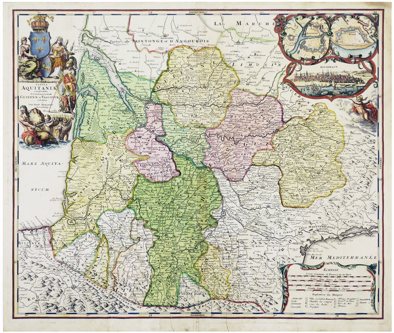
HOMANN (Johann Baptist).
[AQUITAINE] Tabula Aquitaniæ complectens gubernationem Guiennæ et Vasconiæ exhibita.
Nuremberg, [circa 1720]. 478 x 570 mm.
書籍販売業者の参照番号
: LBW-6109
|
|
|
HOMANN (Jean-Baptiste)
[Carte géographique]. Principatus Isenacensis cum adjacentibus vicinorum Statuum.
Nuremberg, Homann, (c.1720). 57 x 50 cm à la cuvette + marges.
書籍販売業者の参照番号
: 14258
|
|
|
HOMANN (Jean-Baptiste)
[Carte géographique]. Ducatus Pomeraniae novissima tabula anteriorem et interiorem divisa, quatenus subsunt coronis Sueciae et Borussiae...
Nuremberg, Homann, (c.1720). 58,5 x 50 cm à la cuvette + marges.
書籍販売業者の参照番号
: 14259
|
|
|
HOMANN (Jean-Baptiste)
[Carte géographique]. Ducatus Luxemburgi tam in Maiores quàm Minores eiusdem ditiones accurate distinctus et exhibitus.
Nuremberg, Homann, (c.1720). 58,4 x 48,6 cm + marges.
書籍販売業者の参照番号
: 14260
|
|
|
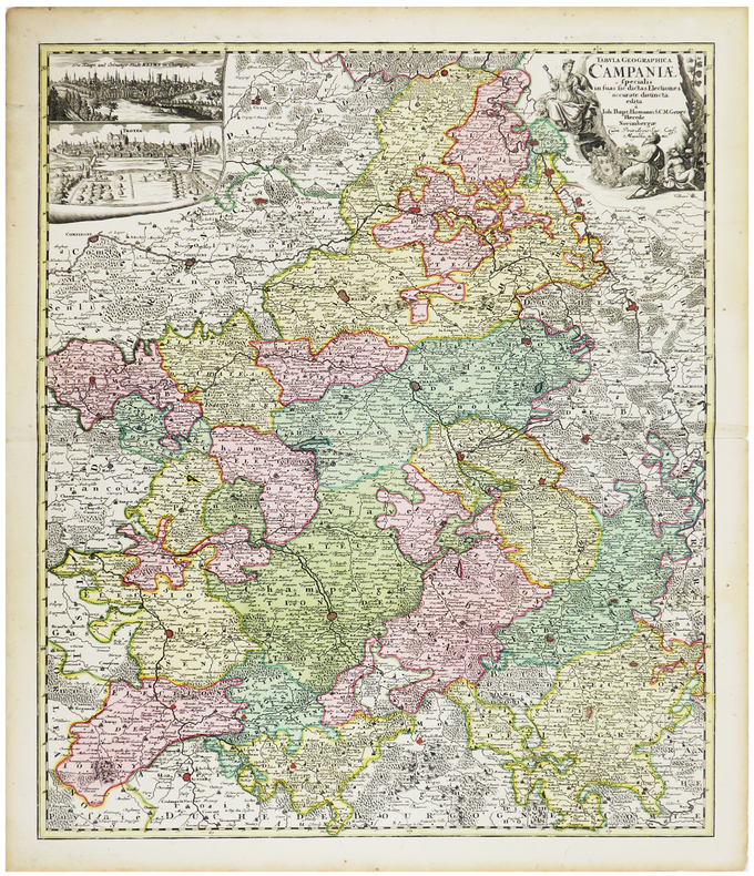
HOMANN (Johann Baptist).
[CHAMPAGNE] Tabula geographica specialis in suas sic dictas electiones accurate distincta edita.
Nuremberg, [circa 1720]. 574 x 488 mm.
書籍販売業者の参照番号
: LBW-6259
|
|
|
HOMANN (Héritiers de);
[CROATIE/BOSNIE/SERBIE] Regnum Bosniae, una cum finitimis Croatiae, Dalmatiae, Slavoniae, Hung. et Serviae partibus - Regni Serviae pars, una cum finitimis Valachiae & Bulgariae.
Nuremberg vers 1740 En 4 feuilles jointes de 605 mm x 1,11 m, dont une partie mobile de 310 x 185 mm.
書籍販売業者の参照番号
: LBW-1799

|
|
|
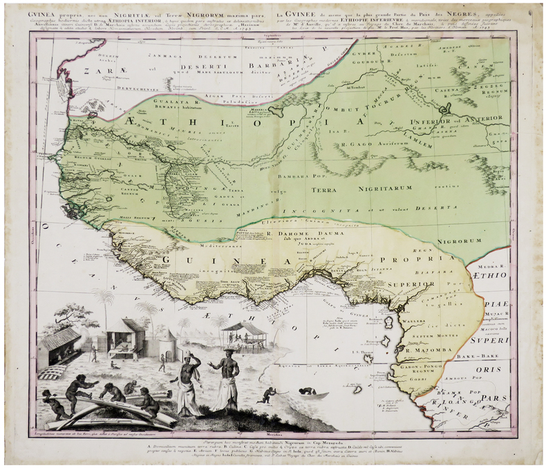
HOMANN (Héritiers de).
[GUINÉE] Guinea propria, nec non Nigritiæ vel Terræ Nigrorum maxima pars, geographis hodiernis dicta utraque Æthiopia inferior - La Guinée de même que la plus grande partie du Pais des Nègres, appellées par les géographes modernes Éthiopie inférieure & méridionale.
Nuremberg, Homann Héritiers, 1745. 493 x 552 mm.
書籍販売業者の参照番号
: LBW-6411
|
|
|
HOMANN (Johann Baptist);
[METZ] Accurata rapraesentatio ichnographica urbis episcopalis in Ducatu Lotharingiae, dictae Metae.
Nuremberg 1739 470 x 556 mm.
書籍販売業者の参照番号
: LBW-403

|
|
|
HOMANN (Johann Baptist).
[PAVILLONS] Flaggen aller Seefahrenden Potenzen und Nationen in der gantzen Weldt.
Nuremberg, [circa 1720]. 495 x 587 mm.
書籍販売業者の参照番号
: LBW-4462

|
|
|
HOMANN (Héritiers de).
[PANAMA] Portus Pulchri in Isthmo Panamensi - Scenographia Portus Pulchri.
[Nuremberg], Homann Héritiers, 1740. 480 x 282 mm.
書籍販売業者の参照番号
: LBW-5884

|
|
|
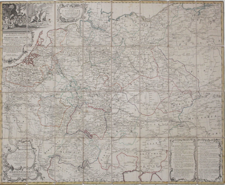
HOMANN (Héritiers de).
[POSTES] Nouvelle carte géographique des postes d'Allemagne - Neue und vollstændige Postkarte durch ganz Deutschland.
Nuremberg, Héritiers de Homann, 1786. En 32 sections montées sur toile et pliées, formant une carte de 776 x 968 mm.
書籍販売業者の参照番号
: LBW-4318
|
|
|
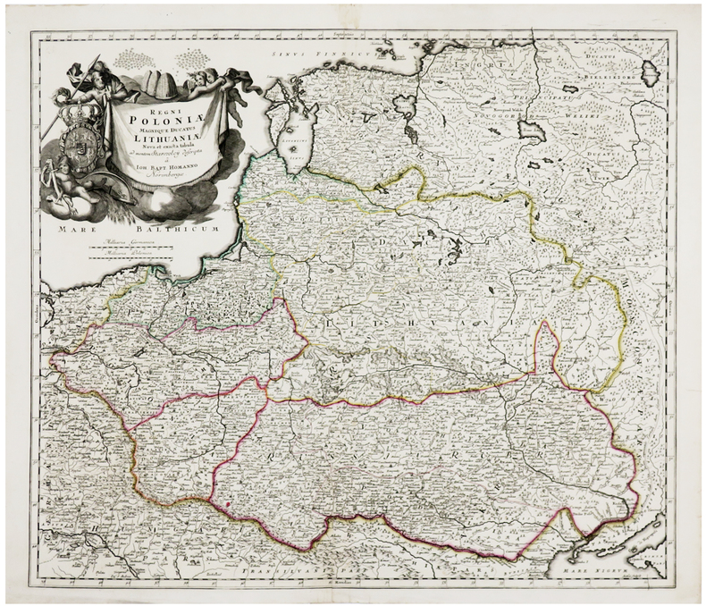
HOMANN (Johann Baptist).
[POLOGNE/LITUANIE] Regni Poloniæ magnique Ducatus Lithuaniæ.
Nuremberg, [circa 1710]. 492 x 568 mm.
書籍販売業者の参照番号
: LBW-6237
|
|
|
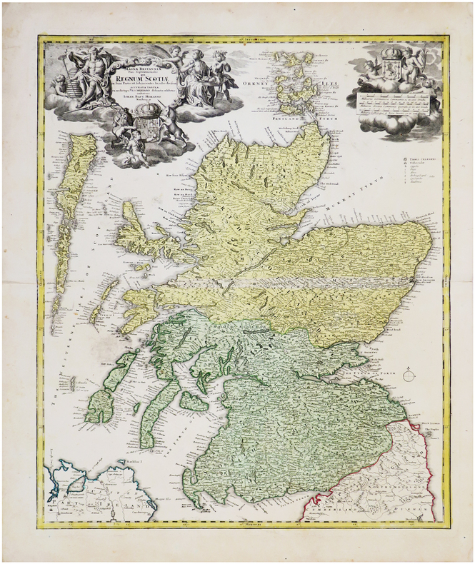
HOMANN (Johann Baptist).
[ÉCOSSE] Magnæ Britanniæ pars septentrionalis qua regnum Scotiæ.
Nuremberg, [circa 1730] 574 x 478 mm.
書籍販売業者の参照番号
: LBW-6539
|
|
|
HOMANN (Johann Baptist).
Accurater Grundriss u: Gegend der Koenigl. Gross-Brittanischen Haupt und Residentz-Stadt London.
Nuremberg, [circa 1730]. 489 x 580 mm.
書籍販売業者の参照番号
: LBW-680
|
|
|
HOMANN (Successeurs)
ATLAS NOVUS REIPUBLICAE HELVETICAE XX MAPPIS COMPOSITUS SUMTIBUS HOMANNIANIS HEREDIBUS.
1769 Nuremberg, 1769. 33x52,5 cm. Recueil de 20 grandes cartes de la Suisse sur double pages, en couleurs ! Augmenté d'une carte de Neuchâtel et Valangin dressée en 1778. Reliure de la fin du XVIIIème siècle ou du début du XIXème siècle en demi-basane à petits coins. Plats recouverts de papier beige moucheté. Dos lisse orné de bandes dorées. Titre sur pièce de couleur orangée. Petites traces d'usage sur la reliure et papier très légèrement bruni par endroit, sinon ouvrage en excellent état et complet, ce qui est exceptionnel !
書籍販売業者の参照番号
: 1564
|
|
|
HOMANN Eredi Johannes Baptiste (1730 - 1813)
Neue Welt Karte
Carta geografica de l mondo inserita nell'atlante degli eredi della tipografia Homann. Dal punto di vista cartografico la mappa presenta diverse innovazioni ed aggiornamenti, soprattutto nel Pacifico dove sono mostrate le scoperte di Cook del 1770. I Grandi Laghi si presentano come un unico enorme specchio d'acqua e la California ha una forma strana, con la Baja che sembra quasi un'isola. L'Australia comprende diversi toponimi sulla costa orientale, frutto delle scoperte di Cook nel 1770. Tuttavia, l'isola di Van Diemens è ancora mostrata collegata alla terraferma. Sono disegnate le rotte di diverse esplorazioni della fine del XVIII secolo. Johann Baptist Homann è stato un geografo e cartografo tedesco; nel 1702 fondò la sua casa editrice. Homann acquisì fama come uno dei principali cartografi tedeschi, e nel 1715 fu nominato geografo imperiale dall'imperatore Carlo VI. Nello stesso anno fu anche nominato membro dell'Accademia Prussiana delle Scienze a Berlino. Nel 1716 Homann pubblicò il suo capolavoro Grosser Atlas ueber die ganze Welt. Numerose mappe furono redatte in collaborazione con l'incisore Christoph Weigel. Homann morì a Norimberga nel 1724. Gli successe suo figlio Johann Christoph (1703-1730). L'azienda continuò dopo la sua morte come azienda degli eredi Homann, gestita da Johann Michael Franz e Johann Georg Ebersberger. Dopo successivi cambiamenti nella gestione, l'azienda si sciolse nel 1852. Incisione in rame, finemente colorata a mano, in ottimo stato di conservazione. This interesting world map presents some curious cartography, given the date of the map. The Great Lakes are shown as one huge body of water and California is strangely shaped with the Baja nearly appearing as an island. Australia includes several place names on the eastern coast, which resulted from Cook's discoveries in 1770. However, Van Diemens Land is still shown connected to the mainland. The tracks of several late 18th century expeditions are shown. Color key and German text panel below the hemispheres. Johann Baptist Homann was a German geographer and cartographer; in 1702 he founded his own publishing house. Homann acquired renown as a leading German cartographer, and in 1715 was appointed Imperial Geographer by Emperor Charles VI. In the same year he was also named a member of the Prussian Academy of Sciences in Berlin. In 1716 Homann published his masterpiece Grosser Atlas ueber die ganze Welt; numerous maps were drawn up in cooperation with the engraver Christoph Weigel the Elder. Homann died in Nuremberg in 1724 and was succeeded by his son Johann Christoph (1703-1730). The company carried on upon his death as Homann heirs company, managed by Johann Michael Franz and Johann Georg Ebersberger. After subsequent changes in management the company folded in 1852. Etching with fine later hand colour, very good condition.

|
|
|
HOMANN Eredi Johannes Baptiste (1730 - 1813)
Urbis Romae Ichnographia à Leonardo Bufalino…
Pianta geometrica con elevazione, pubblicata a Norimberga dalla tipografia degli eredi di Johannes Baptiste Homann nel 1755. Si tratta di una rielaborazione, senza alcun aggiornamento, dell'importante rilievo di Leonardo Bufalini (1551), riportato in voga da Giovan Battista Nolli nel 1748. La legenda di 307 rimandi in latino è ripesa proprio dalla riduzione di Nolli, e ne dimostra la diretta derivazione. Tuttavia la pianta degli eredi Homann, stampata su quattro fogli e quindi di dimensioni maggiori, risulta decisamente più leggibile. "La pianta di Roma di Leonardo Bufalini è la prima rappresentazione coerente della città e la più importante raffigurazione ortogonale fino alla pianta grande di Giambattista Nolli (1748). Bufalini si occupò di tutte le fasi della sua realizzazione, dal rilievo all’incisione, impiegando un lungo tempo: sette anni, secondo Onofrio Panvinio, venti secondo l’editore Antonio Trevisi. La Pianta di Roma fu stampata presso il tipografo Antonio Blado il 26 maggio 1551 a Roma, con privilegio decennale della Repubblica di Venezia e la dedica a Carlo V e a papa Giulio III. Si tratta di un’opera monumentale: una xilografia in dodici fogli e quattro strisce laterali. Nessun esemplare della prima edizione è noto; se ne conoscono solo tre della seconda edizione, pubblicata sempre a Roma, dall’editore Antonio Trevisi da Lecce, due conservati alla Biblioteca Vaticana (di cui uno incompleto) e un terzo alla British Library di Londra. Sebbene la pianta sia basata su rilievi effettuati dall’autore con grande perizia, non mancano elementi di fantasia: molti monumenti antichi sono stati aggiunti, completati e ricostruiti liberamente. Del resto, è lo stesso autore a sottolineare questa ambivalenza, dichiarando di voler presentare “la città che oggi è abitata…aggiungendo la [città] antica, un tempo sovrana del mondo…” Bufalini incluse nella pianta anche un autoritratto in cui è raffigurato con in mano il compasso a due punte, mentre a sinistra sono rappresentati i suoi strumenti di lavoro, fra cui la squadra e la bussola nautica. Per una più completa trattazione degli strumenti di misurazione utilizzati e per l’accuratezza della pianta bufaliniana si rimanda ai numerosi studi pubblicati. La fonte primaria utilizzata da Bufalini è la Roma antica di Bartolomeo Marliano, inserita nella sua Urbis Romae Topographia, che ha lo stesso orientamento e la stessa precisione nei particolari. Fin dalla sua pubblicazione nel 1551, la pianta del Bufalini esercitò una notevole influenza sulle successive piante della città fino al 1748, anno in cui Giambattista Nolli ne pubblicò una copia ridotta insieme alla sua pianta grande, che si impose quale nuovo modello" (cfr. B/R p. 2372). Johann Baptist Homann è stato un geografo e cartografo tedesco; nel 1702 fondò la sua casa editrice. Homann acquisì fama come uno dei principali cartografi tedeschi, e nel 1715 fu nominato geografo imperiale dall'imperatore Carlo VI. Nello stesso anno fu anche nominato membro dell'Accademia Prussiana delle Scienze a Berlino. Nel 1716 Homann pubblicò il suo capolavoro Grosser Atlas ueber die ganze Welt. Numerose mappe furono redatte in collaborazione con l'incisore Christoph Weigel. Homann morì a Norimberga nel 1724. Gli successe suo figlio Johann Christoph (1703-1730). L'azienda continuò dopo la sua morte come azienda degli eredi Homann, gestita da Johann Michael Franz e Johann Georg Ebersberger. Dopo successivi cambiamenti nella gestione, l'azienda si sciolse nel 1852. Acquaforte, 4 lastre di dimensioni 495x365 mm ciascuna, stampate su altrettanti fogli di carta vergata coeva, con margini e ancora da unire, in perfetto stato di conservazione. Bibliografia Huelsen (1915), n. 3; Scaccia Scarafoni (1939), n. 136; Marigliani (2007): n. 32. Per la pianta del Bufalini: Bifolco/Ronca (2018), Cartografia e topografia italiana del XVI secolo, pp. 2372-73, tav. 1221. Geometric plan with elevation, published in Nuremberg by the printing hose of Johannes Baptiste Homann's heirs in 1755. It is a reworking, without any updating, of the important relief by Leonardo Bufalini (1551), brought back by Giovan Battista Nolli in 1748. The key-legend of 307 references in Latin is taken from Nolli's reduction, and demonstrates its direct derivation. However, the map of the Homann heirs, printed on four sheets and therefore larger in size, is much more clear. Leonardo Bufalini's map of Rome is the first coherent representation of the city and the most important orthogonal representation up to the large plan by Giambattista Nolli (1748). Bufalini took care of all the phases of its realization, from relief to engraving, using a long time: seven years, according to Onofrio Panvinio, twenty according to the publisher Antonio Trevisi. The Map of Rome was printed at the typographer Antonio Blado on May 26, 1551 in Rome, with the ten-year privilege of the Republic of Venice and dedicates it to Charles V and Pope Julius III. It is a monumental work: a woodcut in twelve sheets and four lateral strips. Although the map is based on reliefs made by the author, there is no lack of elements of fantasy: many ancient monuments have been added, completed and rebuilt freely. The primary source used by Bufalini is Bartolomeo Marliano's ancient Rome, inserted in his Urbis Romae Topographia, which has the same orientation and the same precision in detail. Since its publication in 1551, Bufalini's map exerted a notable influence on the subsequent plans of the city until 1748, the year in which Giambattista Nolli published a reduced copy together with his large plan, which became the new model. Johann Baptist Homann was a German geographer and cartographer; in 1702 he founded his own publishing house. Homann acquired renown as a leading German cartographer, and in 1715 was appointed Imperial Geographer by Emperor Charles VI. In the same year he was also named a member of the Prussian Academy of Sciences in Berlin. In 1716 Homann published his masterpiece Grosser Atlas ueber die ganze Welt; numerous maps were drawn up in cooperation with the engraver Christoph Weigel the Elder. Homann died in Nuremberg in 1724 and was succeeded by his son Johann Christoph (1703-1730). The company carried on upon his death as Homann heirs company, managed by Johann Michael Franz and Johann Georg Ebersberger. After subsequent changes in management the company folded in 1852. Etching, 4 plates 495x365 mm each, printed on as many sheets of coeval laid paper, with margins and yet to be joined, in perfect condition. Literature Huelsen (1915), no. 3; Scaccia Scarafoni (1939), n. 136; Marigliani (2007): n. 32.

|
|
|
HOMANN Johann Baptist (1663 - 1724)
Urbis Romae Veteris ac Modernae accurata delineatio…
Pianta a proiezione mista, orientata con il nord a sinistra, ripresa dalla pianta di Giovan Battista Falda. "E' una copia della pianta di Johannes De Ram senza alcun aggiornamento. In alto a destra lo stemma di Clemente XI (1700-1721). Sebbene stampata intorno al 1720 raffigura la città alla fine del Seicento, come avviene per un cospicuo nucleo di piante derivate dal Falda ed edite nel Nord Europa in questo periodo, nelle quali tutti i cambiamneti si concentrano nei nuovi apparati decorativi e non nel contenuto della pianta stessa" (cfr. Marigliani p. 229, n. 133). La carta fu realizzata da Homann per il suo Grosser Atlas. Johann Baptist Homann è stato un geografo e cartografo tedesco; nel 1702 fondò la sua casa editrice. Homann acquisì fama come uno dei principali cartografi tedeschi, e nel 1715 fu nominato geografo imperiale dall'imperatore Carlo VI. Nello stesso anno fu anche nominato membro dell'Accademia Prussiana delle Scienze a Berlino. Nel 1716 Homann pubblicò il suo capolavoro Grosser Atlas ueber die ganze Welt. Numerose mappe furono redatte in collaborazione con l'incisore Christoph Weigel. Homann morì a Norimberga nel 1724. Gli successe suo figlio Johann Christoph (1703-1730). L'azienda continuò dopo la sua morte come azienda degli eredi Homann, gestita da Johann Michael Franz e Johann Georg Ebersberger. Dopo successivi cambiamenti nella gestione, l'azienda si sciolse nel 1852. Acquaforte, bella coloritura coeva editoriale, in buono stato di conservazione. Mixed projection map, oriented with north on the left, based on the map of Giovan Battista Falda. It is a close copy of the map of Johannes De Ram without any update. In the upper right corner is the coat of arms of Clemente XI (1700-1721). Although printed around 1720 it depicts the city at the end of the seventeenth century, as is the case for a large group of maps derived from Falda and published in Northern Europe in this period, in which all the changes are concentrated in the new decorative apparatus and not in the content of the map itself (see Marigliani p. 229, n. 133). The map was made by Homann for his Grosser Atlas. Johann Baptist Homann was a German geographer and cartographer; in 1702 he founded his own publishing house. Homann acquired renown as a leading German cartographer, and in 1715 was appointed Imperial Geographer by Emperor Charles VI. In the same year he was also named a member of the Prussian Academy of Sciences in Berlin. In 1716 Homann published his masterpiece Grosser Atlas ueber die ganze Welt; numerous maps were drawn up in cooperation with the engraver Christoph Weigel the Elder. Homann died in Nuremberg in 1724 and was succeeded by his son Johann Christoph (1703-1730). The company carried on upon his death as Homann heirs company, managed by Johann Michael Franz and Johann Georg Ebersberger. After subsequent changes in management the company folded in 1852. Etching with fine original colour, good condition. Huelsen (1915): n. 124a; Scaccia Scarafoni (1939): n. 210; C. Marigliani, "Le Piante di Roma delle collezioni private", tav. 133.

|
|
|
Homann, Baptist Johannes:
Systema solare et planetarium ex hypothesi Copernicana secundum elegantissimas illustrissimi quondam Hugenij deductiones novissime collectum & exhibitum. Altkolorierte Kupferstichkarte aus Doppelmayr, Atlas novus coelestis.
48,5 x 56 cm. Darstellung des Sonnensystems und Sternbilder im Tierkreis. Bis an die Randlinien beschnitten und alt aufgezogen. Am linken Seitenrand und an den der rechten unteren Ecke mit insgesamt 3 kleineren Randfehlstellen. - Versand erfolgt ausgerahmt und ohne Rahmen. Bücher de
|
|
|
Homann, Joh. Bapt.:
Saxoniae Tractus Ducatum Magdeburgensem cum suo Circulo Salico. Kupferstichkarte mit Grenz- und Flächenkolorit.
47,5 x 54 cm (Blattgröße 48,5 x 55,5 cm). *Zeigt das Gebiet von Braunschweig und Goslar bis Potsdam und Torgau und Osterburg bis Leipzig. Oben links mit einer Gesamtansicht von Magdeburg (9 x 22,5 cm) in Kupferstich. Unten links Kartusche mit allegorischen Darstellungen. - Sauber und sehr gut erhalten. Landkarten de
|
|
|
Homann, Joh[ann] Bapt[ista
Prospect und Grund-Riss der Kayserl. Residenz Stadt Wien mit negst anligender Gegend und Neuen Linien umb die Vorstadt (mit einer Ansicht von Wien: Prospekt der Kayserl. Residenz Stadt Wien, wie solche von Mitternacht anzusehen).
Nürnberg, Homann (um 1720). altkol. Kupferstichplan, Gesamtmaß: 61x 53 cm, Ansicht: 58x49 cm, in 24 Teilstücke zerschnitten u. auf Leinwand aufgezog., kartenmäßig gefalt., Leinen an den Rändern etw. fransig, auf Rückseite zwei Felder beschriftet. Grundriss der Innenstadt mit den angrenzenden Vorstädten Leopoldstadt, Alsergrund, Josefstadt, Neubau, Margareten, Wieden und Erdberg sowie der noch unregulierten Donau und deren Auen; in re. ob. Ecke Kartusche mit Erklärung von Häusern, Kirchen etc.; unt
書籍販売業者の参照番号
: KART0098

|
|
|
Homann, Johann Baptist
Circulus Saxoniae Inferioris in omnes suos Status et Principatus (um 1720.) [Altkolorierter Kupferstich, gerahmt / handcoloured copper engraving, framed].
o.J. [3 Warenabbildungen] (Johann Baptist Homann, geb. 20.03.1664 in Oberkammlach, heute Unterallgäu, gest. 01.07.1724 in Nürnberg, deutscher Kar
書籍販売業者の参照番号
: 66112CB

|
|
|
Homann, Johann Baptist
Landgraviatus Hassiae Inferioris nova Tabula in qua praecipue ditionis Hasso-Casselense et Comitatus Waldeck. Altkolorierter Kupferstich mit 2 unkolor. figürlichen Kartuschen.
Nürnberg, [ca. 1720]. Darstellung: 48,5 x 57,5 cm. Unter altem Schrägschnittpassepartout.
書籍販売業者の参照番号
: 86051

|
|
|
Homann, Johann Baptist
Mosellae Fluminis Tabula Specialis in qua Archiepiscopatus et Electoratus Trevirensis in suas Praefecturas accuratè divisus ut et Eyfaliae Tractus osten ditur Sumtibus Ioh. Baptistae Homanni Noribergae. Teilkolorierter Kupferstich mit unkol. Kartusche.
Nürnberg, [ca. 1720. 49 x 57,5 cm.
書籍販売業者の参照番号
: 81226

|
|
|
Homann, Johann Baptist
Nova et accurata Carinthiae Ducatus tabula geographica... Kupferstichkarte gerahmt.
Nürnberg, Homann ca. 1730. flächenkolorierte Kupferstichkarte, Bildausschnitt: 57,2x48,2 cm, Außenmaß: 68,7x60 cm; schwarze Holzleiste, Leiste etwas beschabt, eine Ecke leicht abgesplittert. Dekoratives Blatt von Kärnten mit Ansichten der Stadt Klagenfurt, dem Loiblpass und einer Szene vor dem Herzogsstuhl.
書籍販売業者の参照番号
: GRAP0191

|
|
|
Homann, Johann Baptist
Regni Bohemiae. Ducatus Silesiae Marchionatus Moraviae et Lusatiae, Tabula Generalis, sumtibus Joh. B. Homanni. [Altkolorierter Kupferstich, gerahmt / handcoloured copper engraving, framed].
o.J. [2 Warenabbildungen]
書籍販売業者の参照番号
: 66146CB

|
|
|
Homann, Johann Baptist
S. R. I. Circulus Rhenanus Inferior sive Electorum Rheni Complectens Tres Archiepiscopatus, Moguntinum Coloniensem et Trevirensem, Palatinatum Rheni, Comit. Beilstein Newenaer, Inf. Isenberg et Reiferscheit (1730. ) [Altkolorierter Kupferstich, gerahmt / handcoloured copper engraving, framed].
o.J. (Johann Baptist Homann, geb. 20.03.1664 in Oberkammlach, heute Unterallgäu, gest. 01.07.1724 in Nürnberg, deutscher Kar
書籍販売業者の参照番号
: 66614CB
|
|
|
Homann, Johann Baptist (1664-1724):
"Totius Marchionatus Lusatiae tam Superioris quam inferioris Tabula Specialis in suos Comitatus et Dominatus distincta." Altkolorierte Kupferstich-Karte von Homann, um
50 x 58,5 cm (Blatt: 52,5 x 63 cm). *Schöne Homann-Karte der Lausitz in guter Erhaltung und mit Rand. Wird beim Versand ausgerahmt und ohne Rahmen verschickt. (Innerhalb von Deutschland ist auf ausdrücklichen Wunsch und Anfrage bei höheren Portokosten ggf. ein Versand inklusive des Rahmens möglich). Landkarten de
|
|
|
Homann, Johann Baptista:
Landgraviatus Alsatiae tam Superioris quam Inferi(oris) cum utroque Marchionatu Badensi ut et tractu Herciniae Silvae. Kolorierte upferstichkkarte Landkarte des Elsaß mit angrenzendem Baden und Württemberg von Homann.
58 x 48 cm. *Mit kräftigem altem Grenz- und Flächenkolorit. - Sauber und gut erhalten. Landkarten de
|
|
|
Home, Gordon
France
No marks or inscriptions to contents. No creasing to covers. Clean very tight pages with slightly marked rubbed red cloth boards, tanned end papers, rubbed ends of sunned spine, mottled rear board and minor bumping to some corners. 219pp. An account of France and the French in 1914 at the start of WWI - this is the revised 1918 second edition with double the number of illustrations. With 64 tissue-guarded colour plates. The image displayed is one of the 64 in the book - appears to show two soldiers walking with linked arms in Paris.

|
|
|
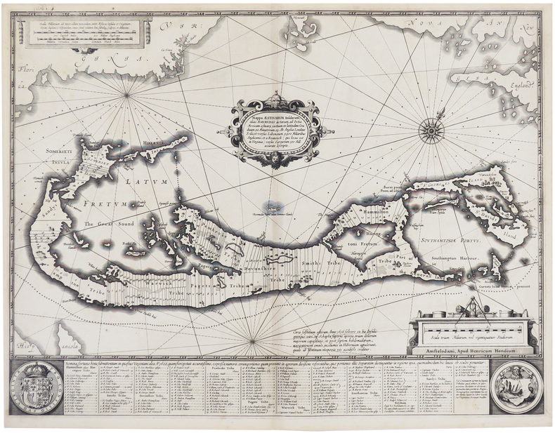
HONDIUS (Henricus).
[BERMUDES] Mappa aestivarum insularum, alias Barmudas.
Amsterdam, Henricus Hondius, [circa 1640]. 392 x 515 mm.
書籍販売業者の参照番号
: LBW-6264
|
|
|
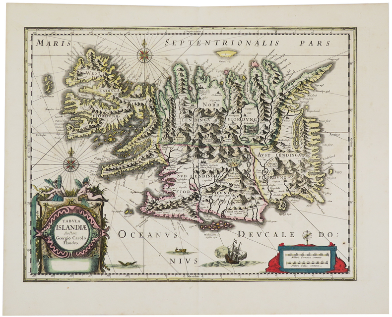
HONDIUS (Jodocus).
[ISLANDE] Tabula Islandiæ Auctore Georgio Carolo Flandro.
[Amsterdam, 1639-1649]. 379 x 494 mm.
書籍販売業者の参照番号
: LBW-5447
|
|
|
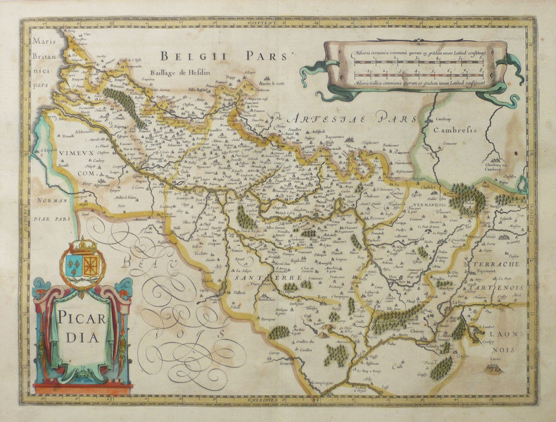
HONDIUS (Jodocus);
[PICARDIE] Picardia.
Amsterdam 1631-1633 375 x 498 mm.
書籍販売業者の参照番号
: LBW-1402
|
|
|
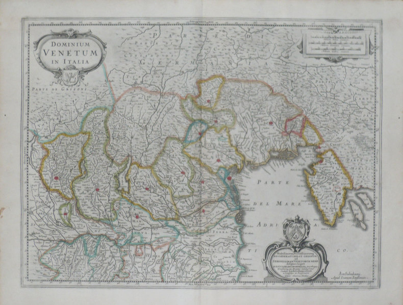
HONDIUS (Henricus);
[VENETIE] Dominium venetum in Italia.
Amsterdam 1639-1649 378 x 498 mm.
書籍販売業者の参照番号
: LBW-1468
|
|
|
HONGRIE
Carte du Royaume de Hongrie avec ses dépendances.
1779 trace de pliure. carte 245 x 330 mm., P. 1779
書籍販売業者の参照番号
: 15321
|
|
|
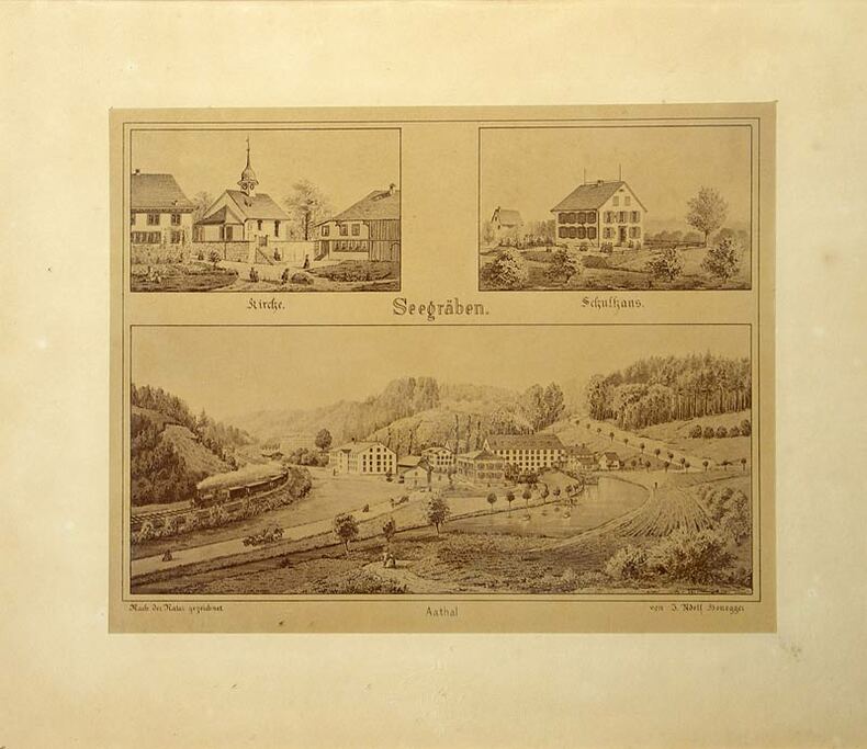
Honegger, Jakob Adolf:
Seegräben - Aathal.
Zürich, Photoraphie J. Ganz, (um 1900). Fotrogr. reproduzierte Tuschzeichnung. Format: 17,2 x 21,6 cm.
書籍販売業者の参照番号
: 463DG
|
|
|
HONDIUS Hendrick (Amsterdam 1597 - 1651)
Nova Totius Terrarum Orbis Geographica Ac Hydrographica Tabula
Buon esemplare della carta del mondo di Henricus (Hendrick) Hondius. Prova del terzo stato di quattro, con la data 1663 che sostituisce l'originale 1630, che si trova nell'Atlas Contractus di Jan Jansson e negli atlanti marini di H. Van Loon.I cartigli abbelliti e le illustrazioni bizzarre fanno di questa mappa un eccellente esempio di cartografia olandese in stile barocco. Circondata da scene mitiche e bestie fantastiche, la carta del mondo stessa include affascinanti illustrazioni di velieri, mostri marini e pesci.Henricus Hondius era figlio del famoso cartografo Jodocus Hondius, il cui ritratto appare nella mappa in basso a sinistra. La carta include anche i ritratti di Gerard Mercator, Claudio Tolomeo e Giulio Cesare. Questi ritratti non sono solo accattivanti e storicamente rilevanti, ma probabilmente sono intesi a connettere la cartografia olandese (esemplificata da Hondius e Mercator) alla tradizione cartografica classica.L'atlante di Mercator-Hondius è stato pubblicato per la prima volta dal padre del cartografo, Joducus Hondius, che acquistò le lastre dell'opera di Mercator, ristampandole ed integrandole con un numero sempre crescente di sue mappe. Oltre alle numerose e bellissime illustrazioni sono notevoli nella carta diverse curiosità geografiche, tra cui la California come isola, le reti fluviali e i laghi del Nord America e le coste dell'Australia. In Sud America, lo Stretto di Le Maire appare ora ad est dello Stretto di Magellano. Lo Stretto di Le Maire era stato scoperto solo quindici anni prima della pubblicazione del primo stato di questa mappa, quando Jacob Le Maire e Willem Schouten condussero una circumnavigazione per minare il monopolio commerciale della Compagnia olandese delle Indie Orientali (VOC). L'inclusione della costa australiana in questa mappa traccia l'inizio della conoscenza olandese del continente australiano, quando la notizie di una "sconosciuta massa di terra ignota meridionale" si stava rapidamente diffondendo.Acquaforte, finemente colorata a mano, in ottime condizioni. A good example of the Henricus Hondius’ world map, a third state with the date 1663 that can be found in the Atlas Contractus of Jan Jansson and in sea atlases of Van Loon.The embellished cartouches and whimsical illustrations make this map an excellent example of baroque-style Dutch cartography. Bordered by mythical scenes and fantastic beasts, the world map itself includes charming illustrations of sailing vessels and fish, adding further visual interest to an already engaging tableau.The mapmaker Henricus Hondius was the son of famed cartographer Joducus Hondius, whose portrait appears at bottom left. The map also includes portraits of Gerardus Mercator, Claudius Ptolemy, and Julius Caesar. These portraits are not only eye-catching and historically relevant, but also serve to establish Dutch cartography (exemplified by Hondius and Mercator) alongside the Roman cartographic tradition.The Mercator-Hondius atlas was first published by the mapmaker’s father, Joducus Hondius. Joducus Hondius secured Mercator’s map engravings from Mercator’s relatives and republished them, along with his own work. The atlas was incredibly commercially successful, and its world map remained unchanged from Mercator’s depiction until the creation of this map by Henricus Hondius and partner Jan Jansson. This Hondius-Jansson version of the Mercator world map was included in all issues of the Mercator-Hondius atlases from 1633 until at least 1658.In addition to the numerous beautiful illustrations and map details, several geographic features included on this map are notable, including California as an island, the riverine networks and lakes of North America, and the coastline of Australia. California is shown here as an island, reflecting a widespread belief among Europeans from the sixteenth to eighteenth centuries. In South America, the Le Maire Strait now appears east of the Strait of Magellan. The Le Maire Strait had been discovered only fifteen years before the first state of this map was published, when Jacob Le Maire and Willem Schouten led a circumnavigation to undermine the trade monopoly of the Dutch East India Company (VOC). Setting this map apart from its contemporaries, it also includes an early appearance of Australia's northern coastline. The inclusion of the Australian coast on this map traces the beginning of Dutch knowledge of the Australian continent, preserving a moment in time when “The Unknown Southern Land” was quickly becoming known.Copperplate with fine hand colouring, in good condition. Shirley, The Mapping of the World: Early Printed World Maps, 1472-1700, map 336

|
|
|
HONDIUS Jodocus (Amsterdam 1563 - 1612)
Typus Orbis Terrarum
Carta tratta dalla prima edizione della Cosmographia Universalis di Paulus Merula, stampata ad Amsterdam nel 1605. Le mappe usate per illustrare la prima edizione della Cosmografia di Merula sono realizzate nel 1598 da Jodocus Hondius e Pieter Van den Keere (Kaerius) e quindi utilizzate dall'editore Cornelis Claesz per illustrare lavori di Apian, Linschoten e Merula. Incisione in rame, inserita in una pagina di testo, in perfette condizioni. Map of the World from the first edition of Cosmographia Universalis by Paul Merula, printed in Amsterdam in 1605.The map was first issued in 1598 by Cornelis Claesz and engraved and realized by Jodocus Hondius and Pietre vand den Keere (Kaerius). Claesz used the plate to illustrate various works he published by Peter Apian, Jan van Linschoten, Paul Merula and others. Copperplate, inset in a page text, very good conditions. King, Miniature Maps, pp. 80/81.

|
|
|
HONDIUS Jr. Jodocus (Amsterdam 1594 -1629)
Typus Orbis Terrarum
Carta geografica tratta dal Tabularum Geographicarum contractarum libri septem di Petrus Bertius, edizione latina del 1616. L'opera contiene 219 carte che illustrano questa nuova versione della geografia del Bertius, per la prima volta pubblicata nel 1612 con le carte di Barent Langenes. Le carte derivano dal grande atlante di Mercator/Hondius, delle quali molte rappresentano una semplice riduzione. "After the death of Cornelis Claesz in 1609, Jodocus Hondius II became the new publisher of the work, composed by 7 parts in 1, with engraved title-page and 220 full-page engraved maps in text. All the maps were newly engraved and slightly larger in size, because Hondius was not able to acquire the original plates. With the new plates the work was definitely improved and enjoyed a growing demand of the public, which at that time had the choice between the Atlas Minor by Mercator and Bertius' Tabularum Geographicarum. The 219 plates, with the oval world map appearing twice, were produced to illustrate a new version of the geography of Bertius, published in 1616. According to King, their correct attribution is by Hondius, after Mercator and Hondius, taken from Bertius, who was only responsible for revising his text again" [cfr. G. King, Miniature Antique Maps]. Incisione in rame, perfette condizioni. A superior rival to the pocket Ortelius atlas appeared about 1598, under the imprint of Barent Langenes and Cornelis Claesz. Claesz also published the Tabularum Geographicarum contractarum libri septem, edition with texy by Petrus Bertius, in 1600. After the death of Cornelis Claesz in 1609, Jodocus Hondius II became the new publisher of the work, composed by 7 parts in 1, with engraved title-page and 220 full-page engraved maps in text. All the maps were newly engraved and slightly larger in size, because Hondius was not able to acquire the original plates. With the new plates the work was definitely improved and enjoyed a growing demand of the public, which at that time had the choice between the Atlas Minor by Mercator and Bertius' Tabularum Geographicarum. The 219 plates, with the oval world map appearing twice, were produced to illustrate a new version of the geography of Bertius, published in 1616. According to King, their correct attribution is by Hondius, after Mercator and Hondius, taken from Bertius, who was only responsible for revising his text again. "After the death of Cornelis Claesz in 1609, Jodocus Hondius II became the new publisher of the work, composed by 7 parts in 1, with engraved title-page and 220 full-page engraved maps in text. All the maps were newly engraved and slightly larger in size, because Hondius was not able to acquire the original plates. With the new plates the work was definitely improved and enjoyed a growing demand of the public, which at that time had the choice between the Atlas Minor by Mercator and Bertius' Tabularum Geographicarum. The 219 plates, with the oval world map appearing twice, were produced to illustrate a new version of the geography of Bertius, published in 1616. According to King, their correct attribution is by Hondius, after Mercator and Hondius, taken from Bertius, who was only responsible for revising his text again" [cf. G. King, Miniature Antique Maps]. Copperplate, in very good conditions. Koeman p. 42; King p. 96/99.

|
|
|
HONDIUS Jr. Jodocus (Amsterdam 1594 -1629)
Typus Orbis Terrarum
Carta geografica tratta dal Tabularum Geographicarum contractarum libri septem di Petrus Bertius, edizione latina del 1616. L'opera contiene 219 carte che illustrano questa nuova versione della geografia del Bertius, per la prima volta pubblicata nel 1612 con le carte di Barent Langenes. Le carte derivano dal grande atlante di Mercator/Hondius, delle quali molte rappresentano una semplice riduzione. "After the death of Cornelis Claesz in 1609, Jodocus Hondius II became the new publisher of the work, composed by 7 parts in 1, with engraved title-page and 220 full-page engraved maps in text. All the maps were newly engraved and slightly larger in size, because Hondius was not able to acquire the original plates. With the new plates the work was definitely improved and enjoyed a growing demand of the public, which at that time had the choice between the Atlas Minor by Mercator and Bertius' Tabularum Geographicarum. The 219 plates, with the oval world map appearing twice, were produced to illustrate a new version of the geography of Bertius, published in 1616. According to King, their correct attribution is by Hondius, after Mercator and Hondius, taken from Bertius, who was only responsible for revising his text again" [cf. G. King, Miniature Antique Maps]. Incisione in rame, perfette condizioni. A superior rival to the pocket Ortelius atlas appeared about 1598, under the imprint of Barent Langenes and Cornelis Claesz. Claesz also published the Tabularum Geographicarum contractarum libri septem, edition with texy by Petrus Bertius, in 1600. After the death of Cornelis Claesz in 1609, Jodocus Hondius II became the new publisher of the work, composed by 7 parts in 1, with engraved title-page and 220 full-page engraved maps in text. All the maps were newly engraved and slightly larger in size, because Hondius was not able to acquire the original plates. With the new plates the work was definitely improved and enjoyed a growing demand of the public, which at that time had the choice between the Atlas Minor by Mercator and Bertius' Tabularum Geographicarum. The 219 plates, with the oval world map appearing twice, were produced to illustrate a new version of the geography of Bertius, published in 1616. According to King, their correct attribution is by Hondius, after Mercator and Hondius, taken from Bertius, who was only responsible for revising his text again. "After the death of Cornelis Claesz in 1609, Jodocus Hondius II became the new publisher of the work, composed by 7 parts in 1, with engraved title-page and 220 full-page engraved maps in text. All the maps were newly engraved and slightly larger in size, because Hondius was not able to acquire the original plates. With the new plates the work was definitely improved and enjoyed a growing demand of the public, which at that time had the choice between the Atlas Minor by Mercator and Bertius' Tabularum Geographicarum. The 219 plates, with the oval world map appearing twice, were produced to illustrate a new version of the geography of Bertius, published in 1616. According to King, their correct attribution is by Hondius, after Mercator and Hondius, taken from Bertius, who was only responsible for revising his text again" [cf. G. King, Miniature Antique Maps]. Copperplate, in very good conditions. Shirley 291

|
|
|
Honegger, Jakob Adolf
Seegräben - Aathal.
Zürich, Photoraphie J. Ganz, (um 1900). Fotrogr. reproduzierte Tuschzeichnung. Format: 17,2 x 21,6 cm. + Wichtig: Für unsere Kunden in der EU erfolgt der Versand alle 14 Tage verzollt ab Deutschland / Postbank-Konto in Deutschland vorhanden +, 463DG
書籍販売業者の参照番号
: 463DG

|
|
|
 検索結果のメールを受信する
 PDFファイルの検索結果をダウンロード
 RSSフィード


