|
Illustrated by Ils. maps/photographs
HANDBOOK TO HOLLAND.
London: Ward Lock and Co. no date c1920's 7th ed. rev. Small/red limp covers. Nice copy. London: Ward, Lock and Co. no date c1920's unknown
Ссылка продавца : 002485
|
|
|
Illustrated National Geographic Maps Trails
Hawaii Volcanoes National Park National Geographic Trails Illustrated Map
National Geographic Maps. MAP. 1566953294 Brand NewVCF . New. 2010. National Geographic Maps unknown
Ссылка продавца : DTH-S-9781566953290 ISBN : 1566953294 9781566953290

|
|
|
Illustrated National Geographic Maps Trails
Jasper National Park Map Pack Bundle National Geographic Trails Illustrated Map
National Geographic Maps. MAP. 1566957397 Brand New! No Remainder Marks or Worn Dirty Overstocks!VCF . New. National Geographic Maps unknown
Ссылка продавца : OTF-S-9781566957397 ISBN : 1566957397 9781566957397
|
|
|
Illustrated National Geographic Maps Trails
John Muir Trail Topographic Map Guide National Geographic Topographic Map Guide National Geographic Topographic Map Guide 1001
National Geographic Maps. MAP. 1566956897 Brand NewVCF . New. National Geographic Maps unknown
Ссылка продавца : DTH-S-9781566956895 ISBN : 1566956897 9781566956895
|
|
|
Illustrated by Maps
Land for New Hampshire . Final Report of the New Hampshire Land Conservtion Investment Program and the Trust for New Hampshire Lands.
Nh: The Conservation Authority 1993 1993 Spiral Bound. NF/NA. First. 4to - over 9�" - 12" tall. VERY SCARCE: Many Many Maps with town & Parcel descriptions. App. 250 pages. Nh: The Conservation Authority, 1993 unknown
Ссылка продавца : 011248
|
|
|
Illustrated National Geographic Maps Trails
Mount Rainier National Park National Geographic Trails Illustrated Map 217
National Geographic Maps. MAP. 1566953456 Brand NewVCF . New. National Geographic Maps unknown
Ссылка продавца : DTH-S-9781566953450 ISBN : 1566953456 9781566953450

|
|
|
Illustrated National Geographic Maps Trails
Mount Rainier National Park National Geographic Trails Illustrated Map 217
National Geographic Maps. MAP. 1566953456 Brand New! Not Overstocks or Low Quality Book Club Editions! Direct From the Publisher! We're not a giant faceless warehouse organization! We're a small town bookstore that loves books and loves it's customers! Buy from us and you get great service as well as a great price! Your business is valued and your satisfaction is guaranteed!VCF . New. National Geographic Maps unknown
Ссылка продавца : OTF-9781566953450 ISBN : 1566953456 9781566953450
|
|
|
Illustrated National Geographic Maps Trails
National Geographic Trails Illustrated Map 210 Canyonlands UT
National Geographic Maps. MAP. 156695326X Brand NewVCF . New. National Geographic Maps unknown
Ссылка продавца : DTH-S-9781566953269 ISBN : 156695326X 9781566953269

|
|
|
Illustrated National Geographic Maps Trails
North Cascades National Park National Geographic Trails Illustrated Map
National Geographic Maps. MAP. 1566953537 Brand NewVCF . New. National Geographic Maps unknown
Ссылка продавца : DTH-S-9781566953535 ISBN : 1566953537 9781566953535

|
|
|
Illustrated National Geographic Maps Trails
Olympic National Park National Geographic Trails Illustrated Map
National Geographic Maps. MAP. 1566954029 Brand NewVCF . New. National Geographic Maps unknown
Ссылка продавца : DTH-S-9781566954020 ISBN : 1566954029 9781566954020

|
|
|
Illustrated National Geographic Maps Trails
Shenandoah National Park National Geographic Trails Illustrated Map
National Geographic Maps. MAP. 1566953650 Brand NewVCF . New. National Geographic Maps unknown
Ссылка продавца : DTH-S-9781566953658 ISBN : 1566953650 9781566953658

|
|
|
Illustrated National Geographic Maps Trails
Yosemite National Park National Geographic Trails Illustrated Map
National Geographic Maps. MAP. 1566952999 Brand NewVCF . New. National Geographic Maps unknown
Ссылка продавца : DTH-S-9781566952996 ISBN : 1566952999 9781566952996

|
|
|
Illustrated National Geographic Maps Trails
Yosemite National Park National Geographic Trails Illustrated Map
National Geographic Maps. MAP. 1566952999 Brand New! Not Overstocks or Low Quality Book Club Editions! Direct From the Publisher! We're not a giant faceless warehouse organization! We're a small town bookstore that loves books and loves it's customers! Buy from us and you get great service as well as a great price! Your business is valued and your satisfaction is guaranteed!VCF . New. National Geographic Maps unknown
Ссылка продавца : OTF-9781566952996 ISBN : 1566952999 9781566952996
|
|
|
Illustrated National Geographic Maps Trails
Zion National Park National Geographic Trails Illustrated Map
National Geographic Maps. MAP. 1566952972 Brand New! Not Overstocks or Low Quality Book Club Editions! Direct From the Publisher! We're not a giant faceless warehouse organization! We're a small town bookstore that loves books and loves it's customers! Buy from us and you get great service as well as a great price! Your business is valued and your satisfaction is guaranteed!VCF . New. National Geographic Maps unknown
Ссылка продавца : OTF-S-9781566952972 ISBN : 1566952972 9781566952972

|
|
|
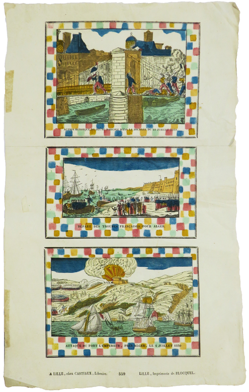
IMAGERIE de LILLE & RÉVOLUTION de JUILLET.
Action héroïque du jeune Darcole dans la journée du 28 juillet 1830 - Départ des troupes françaises pour Alger - Attaque du Fort l'Empereur, près Alger, le 4 juillet 1830.
Lille, Castiaux et Imprimerie de Blocquel, [circa 1830]. En deux feuilles jointes de 400 x 168 mm.
Ссылка продавца : LBW-5888
|
|
|
Imbert Pierre
Bridge contrat. Le bridge national français, deux-trèfles, blackwood, chelems
Editions du vieux Monaco Brochure 1947 In-12 (11,5 x 17,7 cm), brochure, 95 pages ; rousseurs et quelques marques d'usage sur les plats,par ailleurs assez bon état général. Livraison a domicile (La Poste) ou en Mondial Relay sur simple demande.
Ссылка продавца : dm504
|
|
|
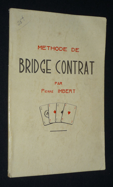
Imbert Pierre
Méthode de bridge contrat
Imbert Pierre Brochure 1940 In-12 (11,5 x 17,8 cm), brochure, 50 pages ; quelques marques d'usage sur les plats, bon état général. Livraison a domicile (La Poste) ou en Mondial Relay sur simple demande.
Ссылка продавца : qq1392
|
|
|
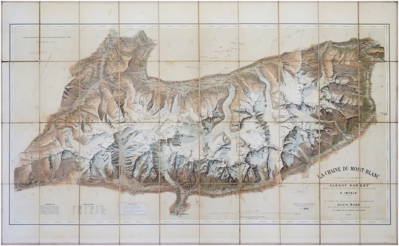
IMFELD (Xaver) & BARBEY (Albert).
[MONT-BLANC] La Chaîne du Mont Blanc. Carte au 1/50 000.
Berne, Kümmerly frères, 1896-1905. En 40 sections montées sur toile et repliées, formant une carte de 0,64 x 1,06 m ; étiquette au dos de la Maison Andriveau-Goujon, H. Barrère, à Paris.
Ссылка продавца : LBW-8045
|
|
|
Imfeld, X(aver)
Gebirgspanorama vom Belvedère auf dem Zürichberg. Erweiterte Ausgabe des Zürichbergpanorama's oberhalb der Karolinenburg von Alb(ert) Heim.
Zürich, Caesar Schmidt, o.J. (1877). Gef. Federlithographie (Leporello) in Halbleinenumschlag (8°). Bildformat: 16,8 x 167 cm. Blattformat: 19,1 x 168 cm. + Wichtig: Für unsere Kunden in der EU erfolgt der Versand alle 14 Tage verzollt ab Deutschland / Postbank-Konto in Deutschland vorhanden +, 1544A (Einbanddeckel stärker berieben und bestossen).
Ссылка продавца : 1544AG

|
|
|
IMHOF, Eduard:
Die Ältesten Schweizerkarten. Mit einem Faksimile der ältesten gedruckten Schweizerkarte von 1513 und 3 Abbildungen.
Zürich / Leipzig Orell Füssli Verlag, 1939, in-4to, (Querformat), 15 S. mit 3 Abb. + 1 gef. Kartenbeilage ‘Tabula Nova Heremi Helvetioru’ (ca. 44x57 cm), Original-Pappband mit Titelschild, Orig.-Umschlag.
Ссылка продавца : 129530aaf
|
|
|
IMHOF, Eduard:
Landkartenkunst, gestern, heute, morgen. Hrsg. v.d. Naturforschenden Gesellschaft in Zürich auf das Jahr 1968. 170. Stück,
Zürich, Kommissionsverlag Leemann AG., 1968, in-8vo, 35 S., 17 s./w. ill + 3 farbtafeln, Original-Broschüre.
Ссылка продавца : 126359aaf
|
|
|
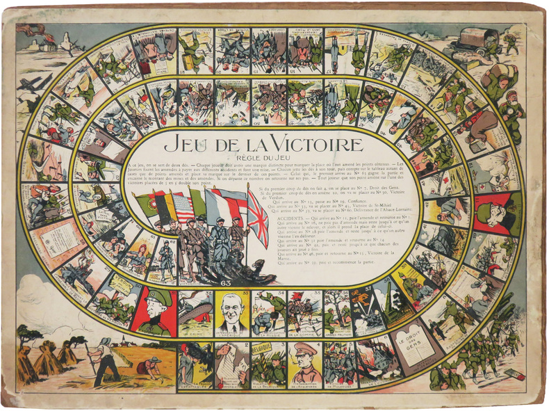
IMPRIMERIE CHAMBRELENT.
Jeu de la Victoire.
Paris, Imp. Chambrelent, [1919]. 277 x 370 mm ; monté sur carton.
Ссылка продавца : LBW-8571
|
|
|
in Full Color Blank Flyleaf Small Sticker Former Owner. SIGNED By Author Brown Illustrations By Velma Grant Maps By George An
Rock & Miinerals of California & Their Stories
Naturegraph Co San Martin Calif. PBO decorated color Wraps with Color Labels of rocks Light rub Wear & tiny Chips Tears Extremities NF-/NF- 1955 Interior Nice tight Clean light Rub Wear FoX 120 Pages InDex some pgs light Wrinkling . Signed by Author. First Edition. Original Wraps. Naturegraph Co, San Martin, Calif. paperback
Ссылка продавца : 21242
|
|
|
Inc Langenscheidt Pub
Insight FlexiMap London
Carrollton TX: American Map Corporation 8/30/2005. Map. New. pp1 London Insight FlexiMap features detailed city street and road maps clearly marked with all the sites and services of particular interest to travelers. Text and photographs offer a wealth of valuable tourist information including "10 sights you shouldn't miss" plus information on transportation visas currency important telephone numbers emergency services and more. NEW Map: Fine condition. Gift Quality. Our Maps are shrink-wrapped and carefully packaged to assure your Map will arrive in good condition. SATISFACTION GUARANTEED American Map Corporation unknown
Ссылка продавца : 162 ISBN : 9812583777 9789812583772
|
|
|
Inc Hedberg Maps
Princeton: Princeton University & Area Streets Professor Pathfinder's Campus Maps
2007-09-10. Good. Ships with Tracking Number! INTERNATIONAL WORLDWIDE Shipping available. May not contain Access Codes or Supplements. May be re-issue. May be ex-library. Shipping & Handling by region. Buy with confidence excellent customer service! unknown
Ссылка продавца : 1885508913 ISBN : 1885508913 9781885508911

|
|
|
Inc Key Maps
Houston Harris County atlas
good. spiral bound softcover. cover and corner wear. creased covers. paperback
Ссылка продавца : 050421A280103 ISBN : 1885822103 9781885822109
|
|
|
Inc St. Louis Area Maps
Wunnenberg's metro-west St. Louis city & county street guide
St. Louis Area Maps Inc 1991 SOFT COVER WIRE RING IN NEAR FINE CONDITION. 3rd Edition. Hardcover. Near Fine. St. Louis Area Maps, Inc hardcover
Ссылка продавца : 149628 ISBN : 1879172046 9781879172043
|
|
|
Inc Streetwise Maps
Streetwise Manhattan
2011-02-03. New. Ships with Tracking Number! INTERNATIONAL WORLDWIDE Shipping available. May be re-issue. Buy with confidence excellent customer service! unknown
Ссылка продавца : 1931257140n ISBN : 1931257140 9781931257145

|
|
|
Inc Streetwise Maps
Streetwise Manhattan
2011-02-03. Good. Ships with Tracking Number! INTERNATIONAL WORLDWIDE Shipping available. May not contain Access Codes or Supplements. May be re-issue. May be ex-library. Shipping & Handling by region. Buy with confidence excellent customer service! unknown
Ссылка продавца : 1931257140 ISBN : 1931257140 9781931257145

|
|
|
Inc Trakker Maps
Florida Gold Coast Atlas: Covering Dade Broward and Palm Beach Counties
Trakker Maps 1989-12-01. 1991 ed. Paperback. Good. Trakker Maps paperback
Ссылка продавца : SONG1877651001 ISBN : 1877651001 9781877651007
|
|
|
Inc Wide World of Maps
Metropolitan Phoenix street atlas
Wide World of Maps 1990-01-01. 1990 ed. Unknown Binding. Used:Good. Wide World of Maps unknown
Ссылка продавца : DADAX0938448382 ISBN : 0938448382 9780938448389
|
|
|
Inc Wide World of Maps
Metropolitan Phoenix street atlas
Wide World of Maps 1990. Good. Wide World of Maps unknown
Ссылка продавца : SONG0938448382 ISBN : 0938448382 9780938448389
|
|
|
Inc Wide World of Maps
Yellow 1 Pinal County Street and Road Atlas - 2005 Edition
<p>Wide World of Maps 2004. Softcover / Spiral Bound. New. New no remainder mark wire-ring bound 86 pp. plus several of index.</p> Wide World of Maps paperback
Ссылка продавца : 2471-NE ISBN : 1887749608 9781887749602
|
|
|
Inc. Five Star Maps
Austin TX Rapid Routes
2011-09-03. Good. Ships with Tracking Number! INTERNATIONAL WORLDWIDE Shipping available. May not contain Access Codes or Supplements. May be re-issue. May be ex-library. Shipping & Handling by region. Buy with confidence excellent customer service! unknown
Ссылка продавца : 1592141862 ISBN : 1592141862 9781592141869

|
|
|
Inc. Five Star Maps
Austin TX Rapid Routes
2011-09-03. New. Ships with Tracking Number! INTERNATIONAL WORLDWIDE Shipping available. May be re-issue. Buy with confidence excellent customer service! unknown
Ссылка продавца : 1592141862n ISBN : 1592141862 9781592141869
|
|
|
Inc. Five Star Maps
Houston TX Metro Rapid Routes
2012-09-02. Good. Ships with Tracking Number! INTERNATIONAL WORLDWIDE Shipping available. May not contain Access Codes or Supplements. May be re-issue. May be ex-library. Shipping & Handling by region. Buy with confidence excellent customer service! unknown
Ссылка продавца : 1592140394 ISBN : 1592140394 9781592140398

|
|
|
Inc. Five Star Maps
Houston TX Metro Rapid Routes
2012-09-02. New. Ships with Tracking Number! INTERNATIONAL WORLDWIDE Shipping available. May be re-issue. Buy with confidence excellent customer service! unknown
Ссылка продавца : 1592140394n ISBN : 1592140394 9781592140398

|
|
|
Inc. Five Star Maps
McAllen Edinburg Mission Weslaco Texas street map
2010-01-01. Good. Ships with Tracking Number! INTERNATIONAL WORLDWIDE Shipping available. May not contain Access Codes or Supplements. May be re-issue. May be ex-library. Shipping & Handling by region. Buy with confidence excellent customer service! unknown
Ссылка продавца : 1592140793 ISBN : 1592140793 9781592140794

|
|
|
Inc. Five Star Maps
San Antonio TX Rapid Routes
2013-02-03. Good. Ships with Tracking Number! INTERNATIONAL WORLDWIDE Shipping available. May not contain Access Codes or Supplements. May be re-issue. May be ex-library. Shipping & Handling by region. Buy with confidence excellent customer service! unknown
Ссылка продавца : 1592140939 ISBN : 1592140939 9781592140930

|
|
|
Inc. Five Star Maps
San Antonio TX Rapid Routes
2013-02-03. New. Ships with Tracking Number! INTERNATIONAL WORLDWIDE Shipping available. May be re-issue. Buy with confidence excellent customer service! unknown
Ссылка продавца : 1592140939n ISBN : 1592140939 9781592140930

|
|
|
Inc. Five Star Maps
Texas Rapid Routes
Five Star Maps Inc 2014-01-01. Map. New. Five Star Maps, Inc unknown
Ссылка продавца : 1592140920-11-13965281 ISBN : 1592140920 9781592140923
|
|
|
Inc. Five Star Maps
Us Interstate Rapid Routes
2014-01-01. New. Ships with Tracking Number! INTERNATIONAL WORLDWIDE Shipping available. May be re-issue. Buy with confidence excellent customer service! unknown
Ссылка продавца : 1592140912n ISBN : 1592140912 9781592140916

|
|
|
Inc. Key Maps
2007 Key Map : Houston Harris County
Used - Good. Item in good condition. Textbooks may not include supplemental items i.e. CDs access codes etc. unknown
Ссылка продавца : 00011469039 ISBN : 1885822553 9781885822550
|
|
|
Inc. Key Maps
2007 Key Map : Houston Harris County
2006-01-01. Spiral-bound. Good. unknown
Ссылка продавца : 1885822553-3-11265864 ISBN : 1885822553 9781885822550
|
|
|
Inc. Key Maps Corporate Author
Houston Harris County Atlas
Key Maps 2010-11-01. 51 Spi. Paperback. Used:Good. Key Maps paperback
Ссылка продавца : DADAX1223000184 ISBN : 1223000184 9781223000183
|
|
|
Inc. Trakker Maps Editor
Myrtle Beach Sc Atlas
Trakker Maps 2001-08-01. Paperback. Good. Trakker Maps paperback
Ссылка продавца : SONG1579521193 ISBN : 1579521193 9781579521196
|
|
|
Inconnu De Nombreuses Cartes Bien Faites Heral Heral
Guerres du xx siecle
Le grand livre du mois. Used - Very Good. Ships from the UK. Former Library book. Great condition for a used book! Minimal wear. 100% Money Back Guarantee. Your purchase also supports literacy charities. Le grand livre du mois unknown
Ссылка продавца : GRP97653732 ISBN : 2702843034 9782702843031
|
|
|
Indes du sud par Viramma Josiane et Jean-Luc Racine.
Une vie de paria. Le rire des asservis. Inde du Sud. 50 illustrations dans le texte, 73 illustrations hors texte, 5 cartes, 1 glossaire, 3 index.
Ed. Plon /UNESCO 1994. Bel exemplaire relié, couverture carton souple, fort in-8, 626 pages.
Ссылка продавца : AUB-6307
|
|
|
INDE ANGLAISE
Inde anglaise. Carte dessin?e par C. Perron sous la direction d'Elis?e Reclus.
Feuille 58x42 cm. Repli?e.
|
|
|
INDRE
Carte d?partementale en couleurs. 100x130cm. Repli?e. Sans date.
Carte seule, sans couverture.
|
|
 Получить результаты поиска по электронной почте
 Загрузить результаты в формате PDF
  RSS-канал


