|
The Arab-Israeli Conflict in Maps
28x21.5 cm. 68 pages. Softcover. Cover slightly stained. Else in good condition.
|
|
|
The chambers of commerce atlas : a systematic survey of the World's trade, economic resources and communications
In folio, cm 40, pp. 112, 33, 16, con numerose carte geografiche a colori. Legatura editoriale in tela blu con titoli in oro al piatto e al dorso. Molto ben conservato. Sul frontepizio: specially prepared for The Times Trade and Engineering Supplement.

|
|
|
The Geographical Journal: Including the Proceedings of the Royal Geographical Society [6 Volume Set] [Without Volume 5.]
Contain Maps. Contain plates in black and white. [6 Volume Set Without Volume 5.] 16X24.5 cm. xiv+128+xvi+118+xvi+126+xviii+xvi+125+xviii+xvi+141+xviii pages. Softcover. Cover slightly chaffed. Cover has age stains. volume 3+6: Spine slightly worn. Else in good condition.
|
|
|
The Handy Royal Atlas of Modern Geography
360x240 mm. VIII+120+56 pages. Gilt hardcover. Cover slightly stained. Cover slightly bumped. Cover corners bumped and slightly worn. Spine slightly yellowing. Spine edges wrinkled. Pages yellowing. Else in good condition.
|
|
|
The Heyden new world atlas.
London, Heyden & Son, (1970). 4°. M. 143 farb. Ktn. 103 S. OKldr. M. Rsign. St. a. Tit.
书商的参考编号 : 134434
|
|
|
The Map Collector !981, n. 14 - 15 - 16 -17. March - June - September - December.
Each: 10 euro

|
|
|
The Map Collector 1980, n. 10 - 11 - 12 - 13.
Each: 10

|
|
|
The Map Collector 1982, n. 18 - 19 - 20- 21. March -June - September - December.
Each: 10 euro

|
|
|
The Map Collector 1983, n: 22 - 23 - 24 - 25. March - June - September - December
each: 10

|
|
|
The Map Collector 1985, n. 30 - 31 - 32 - 33. March - June -September . December.
Each: euro 10

|
|
|
The Map Collector 1986. n. 34 - 35 - 37. Spring - Summer - Winter.
Each : Euro 10

|
|
|
The Map Collector 1987, n. 38 - 40 - 41.

|
|
|
The Map Collector 1992 / 58 . 60 - 61 - Spring - Autumn - Winter.
Each: euro 10.

|
|
|
The Map Collector, !984. n. 26 - 27 - 28 - 29. March . June . September - December
Each: euro 10

|
|
|
The Map Collector, 1979, n. 6 - 7- 8 - 9. March - June - September - December.
Each : !5 euro

|
|
|
The Map Collector, 1988, n.42 - 43 - 44- 45.
Each n.: 10

|
|
|
The Map Collector, 1989. n 46 - 47 - 48 - 49. Spring - Summer - Autumn - Winter.
Each n. : 10 euro

|
|
|
The Map Collector, n. 2 - 3 - 4 - 5.March - June - September - December.
Each: euro 10.

|
|
|
The Map Collector. 62 - 63 - 64 - 65 / Spring -Summer - Autumn -Winter 1993.
Each numero: Euro 10.

|
|
|
The Map Collector. Anno 1991 / Issue n: 54 - 55 . 56 - 57. Spring -Summer - Autumn - Winter.
Each num : 10

|
|
|
The Map Collector. December 1977, issue n. 1.

|
|
|
The Map Collector. Spring 1994, number 66.

|
|
|
Theatrum Orbis Terrarum. Pieter Van den Keere. Germania Inferior. Amsterdam 1617.
Ril. in tela con sovr., cm 45x31, pp 92, molte carte in b/n..Parte anastatica in lingua latina. Volume con leggeri segni del tempo alla sovracop.

|
|
|
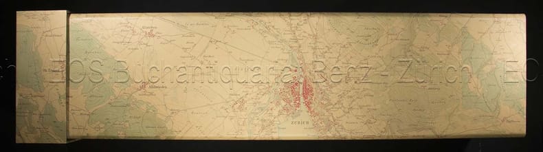
Topographische Karte der Schweiz. 1:100 000. In 20 Blätter / Feuilles.
Bern, Eidg. Landestopographie, 1915 - 29, in-8° (gefaltet), vollständig in 20 numm. gef. Karten. Aufdruck auf Titel-Umschlag Planquadrat’, Orig. Pappschachtel mit Rückentitel.
书商的参考编号 : 129605aaf
|
|
|
Topographische Aufnahme des Kantons Zürich von 1843 - 1851. Urheber: Geographisch Ethnografische Gesellschaft Zürich.
Masstab 1:25000 - Faksimileausgabe. Langnau am Albis. Dorfpresse Langnau. (1989). 14 gerollte Karten (mehrfarbig), 48 x 70 cm. In illustrierter Box. Deckelboden von Schachtel fehlt. Deckel oben mit Schadstellen. Sonst gutes Exemplar.
书商的参考编号 : 3828DB
|
|
|
TOPOGRAFIA ANTICA: Atene, porti e campidoglio, Gerusalemme, Roma antica. Quattro tavole con incisioni in rame tratte dall'ATLANTE della NUOVA ENCICLOPEDIA POPOLARE ITALIANA.
(Codice OS/0258) Le 4 tavole (29,5x21,5 cm) con belle incisioni in rame, sono ORIGINALI, provengono da un volume sciolto. Qualche lieve ingiallitura, ma ottimo stato. A garanzia dell'autenticità, alleghiamo fotocopie di: frontespizio, prefazione (10 pp.) e indice sistematico delle tavole con elenco delle incisioni. ~~~ SPEDIZIONE IN ITALIA SEMPRE TRACCIATA

|
|
|
Topographische Aufnahme des Kantons Zürich von 1843 - 1851. Urheber: Geographisch Ethnografische Gesellschaft Zürich.
Langnau am Albis., Dorfpresse Langnau., (1989). 14 gerollte Karten (mehrfarbig), 48 x 70 cm. In illustrierter Box. + Wichtig: Für unsere Kunden in der EU erfolgt der Versand alle 14 Tage verzollt ab Deutschland / Postbank-Konto in Deutschland vorhanden +, Abb. Masstab 1:25000 - Faksimileausgabe. Deckelboden von Schachtel fehlt. Deckel oben mit Schadstellen. Sonst gutes Exemplar.
书商的参考编号 : 3828DB

|
|
|
Topographischer Atlas der Schweiz (Im Massstab der Originalaufnahmen)
carta topografica cm. 80 x 58 montata su tela e più volte ripieg. scala 1:50000. Zone Val Piora, Val di Campo, Val Ghironico, Biasca, Peccia ecc. Ottimo esempl.
|
|
|
Touring Club Ciclistico Italiano Planimetrie e Profili Ciclistici
Serie di cartine al 125.000 in bross. edit. di cm. 22; i fogli più volte ripiegati raggiungono lunghezze anche di 180 cm. e hanno nella prima parte le planimetrie e i profili, e nella seconda la cartina geografica. fogli estremamente curati nella grafica, in copertina pubblicità. Tutti ottimi. Disponibili: n. 41 - Ventimiglia-Tenda; n. 43 - Pistoia-Cutigliano; n. 49 - Incino-Bellagio. Ognuno 15.00 € Tutti
|
|
|
Treccani - Grande Atlante Treccani. 2 Volumi
Treccani - Grande Atlante Treccani. 2 Volumi. , , CODICE TreccaniCOLLANAAUTORE Piergiorgio Landini, progettazione e direzioneTITOLO Grande Atlante Treccani. 2 VolumiLINGUA italianoLUOGO/EDITORE Roma – Istituto delle enciclopedia italianaANNO DI PUBBLICAZIONE/EDIZIONE 2002 – I edizioneFORMATO 24x31copertina cartonata in tela con dorso in pelle, scritte e fregi sia al piatto che sul dorso in oro N° PAGINE 1.000 Circaillustrazioni a Colori DESCRIZIONE LIBRO Bellissima opera, con cartografia del Touring Club Italiano, in perfetto stato, come nuova, e così suddivisa: Volume CartografiaVolume Indici-Appendice La spedizione "PIEGO DI LIBRI" non è tracciabile e sebbene lo si possa riconoscere come un ottimo servizio, non si escludono rischi che saranno a carico dell'acquirente Per spedizioni internazionali scriveteci per sapere le tariffe applicateFor international shipping please contact us to find out the fees chargedPour les envois internationaux s'il vous plaît nous contacter pour connaître les frais facturés

|
|
|
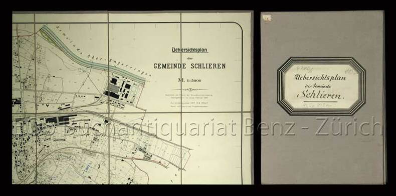
Uebersichtsplan der Gemeinde Schlieren.
Thalwil, Heinr. Müller, 1924. Blattformat: 71,5 x 102 cm.
书商的参考编号 : 478DG
|
|
|
Uebersichtsplan der Gemeinde Schlieren.
Thalwil, Heinr. Müller, 1924. Blattformat: 71,5 x 102 cm. + Wichtig: Für unsere Kunden in der EU erfolgt der Versand alle 14 Tage verzollt ab Deutschland / Postbank-Konto in Deutschland vorhanden +, 478D
书商的参考编号 : 478DG

|
|
|
Undique Ad Terram Sanctam - Cartographic Exhibition from the Eran Laor Collection
21.5x27.5 cm. 33+38 pages. Softcover. Pages slightly age stained. Else in good condition.
|
|
|
Undique Ad Terram Sanctam: Cartographic Exhibition From the Eran Laon Collection.
27.5x21.5 cm. 33 + 38 pages. Cover corners slightly worn. Spine edges slightly worn. Inner cover and pages slightly yellowing. Else in good condition.
|
|
|
Undique ad terram sanctam: Cartographic exhibition from the Eran Laor collection [IN ENGLISH AND HEBVREW].
IN ENGLISH AND HEBREW. 27.5x22cm. 38+33 pages. Softcover. In good condition.
|
|
|
Universo (L'). Rivista mensile. Anni V-XVII. (V: NN. 1-7, 9-12; VI, VII, VIII: NN. 1-12; IX: NN. 7-12; X: NN. 1-6, 8, 10, 11; XI: NN. 1-12; XII: NN. 1-12; XIII: NN. 1-12; XIV: NN. 7-12; XV: NN. 1-12; XVI: NN. 1-12; XVII: NN. 1-12. (Molti articoli di argomento locale su: Osservatorio di Arcetri; Istituto di Ottica di Firenze; le 3 piante iconografiche più antiche di Firenze; origini di Firenze, ecc. Segnaliamo anche: note geologiche ai terremoti bolognesi; il parco Naz. d'Abruzzo; le Paludi Pontine; Rodi, città dei Cavalieri; scavi in Tripolitania; ripopolamento della Palestina con gli Ebrei; grafia europea nella traduzione dei nomi cinesi; recenti studi sull'Atlantide; antiche carte nautiche olandesi; primo volo al Polo Nord del Comandante R.E. Byrd; tunnel della Manica...).
Firenze, Istituto Geografico Militare, 1924-1936, fasc. 140 complessivi (9 annate complete + altri 32), raccolti in voll. 24, copp. fittizie (ma conservate le br. edit. dei fasc.), pp. 571, da 617 a 947 - 1064 - 1072 - 1407 - da 617 a 1321 - 729, da 765 a 888, da 995 a 1067 - 1347 - 742 - da 507 a 978 - 1089 - 1106 - 960. Numerose ill. in b.n. e cartine. Ampia bibliografia (incluse le riviste) e notiziario. Alcune adesioni. Contributi di: R. Almagià, R. Biasutti, C. Basevi, C. Casamorata, A. Loperfido, G. Pullè G. Abetti, E. Masini, G. Boffito, L. Arditi, A. Neppi Modona, L. Giannitrapani, L. Cipriani, ecc. Interessante rivista che tratta di geografia, esplorazioni, etnologia, cartografia, topografia, geologia, astronomia, ecc; numerosi articoli monografici su Oriente (Giappone, Manciuria, Cina, India), America Latina (Brasile, Perù, Bolivia, Cile, Argentina, ecc.), U.R.S.S. e sulle colonie italiane (Libia, Eritrea, Somalia); resoconti di Convegni e congressi: I Convegno Naz. Etrusco a Firenze (1926), II/III Assemblea dell'Unione Astronomica Internaz. (1925, 1928), Congresso Internaz. di Geografia a Cambrige (1928), XIX Riunione della Società Italiana per il progresso delle Scienze (1930), Congresso di studi coloniali di Firenze (1931), ecc.

|
|
|
Valli di Biella e di Gressoney Alta Valsesia.
Volume di cm. 47 contenente una piccola carta generale d'insieme e 36 carte a doppia pagina, ciascuna di cm. 45 x 55 ed applicate su tela. Legatura coeva in mezza pelle con titoli in oro al piatto. Qualche scoloritura al piatto anteriore, peraltro buona conservazione. Interessante insieme, verosimilmente non editoriale e composto da un collezionista del tempo. L'unione di tutte le tavole compone un'ideale, grandissima carta topografica del territorio citato nel titolo.

|
|
|
VEDUTA DEL DUOMO DI MILANO / VUE DE LA CATHEDRALE DE MILAN.
presso Antonio Bossi Negoz.e di Stampe Cont. de' tre Re N. 4091, Milano, 1830 ca. Bellissima veduta della Cattedrale incisa all'acquatinta da D. Landini (mm. 340 x 427 pi margini), sotto passe-partout. Molto ben conservata entro cornice in legno (mm. 520 x 686).
书商的参考编号 : 144562
|
|
|
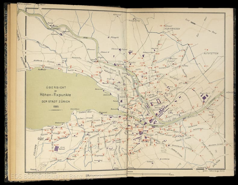
Verzeichniss der Höhen-Fixpunkte im Gebiete der Stadt Zürich. Herausgegeben vom Vermessungsamt der Stadt Zürich
Zürich, Museumsgesellschaft Zürich, 1895. 8°. 166 S., mit vielen ganzseitigen Abbildungen. Halbleinenband mit handschriftlichem Bibliotheks-Rückenschild.
书商的参考编号 : 4834DB
|
|
|
Verhandlungen d. Conferenz d. permanenten Commission d. internationalen Erdmessung. Red. v. A. Hirsch. Verhandl. 1888 (Salzburg), 1890 (Freiburg i.Br.), 1891 (Florenz), 1893 (Genf).
Berlin, Reimer, 1889-94. 4°. M. gef. Ktn. u. Taf. OU. beschmutzt.
书商的参考编号 : 220319
|
|
|
Verhandlungen d. östereichischen Gradmessungs-Kommission. Protokolle über Sitzungen, welche von 17.12.1886-19.10.1911 abgehalten wurden.
Wien, Selbstvlg. d. Öster. Gradmessungs-Komm. 1889-1912. In 2 Bibl.-Einbdn. Rücken stockfl. St. u. Sign. a. Tit.
书商的参考编号 : 220209
|
|
|
VERZEICHNIS DER VOR 1830 ERSCHIENENEN KARTEN UND PLÄNE. (in der) Stadtbibliothek Braunschweig.
Braunschweig, 1984. 4to. 166 (eig. 167) S. Kart. (gebräunt, mehr. Bibl.-Stempel).
书商的参考编号 : 1320982
|
|
|
Verzeichniss der Höhen-Fixpunkte im Gebiete der Stadt Zürich. Herausgegeben vom Vermessungsamt der Stadt Zürich
Zürich, Museumsgesellschaft Zürich, 1895. 8°. 166 S., mit vielen ganzseitigen Abbildungen. Halbleinenband mit handschriftlichem Bibliotheks-Rückenschild. + Wichtig: Für unsere Kunden in der EU erfolgt der Versand alle 14 Tage verzollt ab Deutschland / Postbank-Konto in Deutschland vorhanden +, 4834DB|4834DB_2 [2 Warenabbildungen]
书商的参考编号 : 4834DB

|
|
|
Veröffentlichungen d. Instituts für Erdmessung. H. 6, 8-10, 14.
Bamberg, Meisenbach & Co. 1951-52. M. Taf. u. Abb. Leicht bestoßen.
书商的参考编号 : 220183
|
|
|
Viaggio nelle isole Baleari e Pitiuse
16°, cm 15x9, due volumi in un tomo di pp. 179, (1); 180; legatura in mezza pelle coeva con fregi e titolo in oro al dorso, qualche lievissimo segno del tempo all'esterno, minime fioriture alle pagine per la qualità della carta, peraltro ottimo esemplare. Prima edizione napoletana adorna di 6 rami, tra cui una carta geografica e 3 incisioni in coloritura coeva. L'autore fu un prete cattolico che visse molti anni a Corfù e pubblicò le relazioni dei viaggi che effettuò in numerose isole del Mediterraneo.

|
|
|
Viaggio nelle isole italiane con Guy de Maupassant, A. Valéry, A. Dumas, E. Renan
4°, pp. 57, 32 tavole a colori, rilegatura editoriale, titolo in oro al piatto e dorso, sovracoperta editoriale illustrata a colori, custodia editoriale, Esemplare come nuovo

|
|
|
VIE DEL MONDO . [tutti i numeri pubblicati: 1987 - 1992].
(Codice VA/1106) Nuova testata, edita in collaborazione con National Geographic Society, che continuò la tradizione dell'antica "LE VIE DEL MONDO". Raccolta completa di tutto il pubblicato, dal n° 1 anno I (luglio 1987) all'ultimo numero con il "commiato" del direttore (Anno VI - settembre 1992). In totale 63 riviste, tutte complete di copertine e in ottima conservazione. ~~~ SPEDIZIONE IN ITALIA SEMPRE TRACCIATA

|
|
|
Weltatlas. Die Staaten d. Erde u. ihre Wirtschaft.
Leipzig, Enzyklopädie, 1957. 4°. M. 1 beilieg. Legende u. 105 farb. Ktn. 58 S. Reg. OLwd.
书商的参考编号 : 123947
|
|
|
Westindien. Central-America und das nördliche und nordwestliche Süd America. Nueva Granada und Venezuela. Bearb. von Heinrich Kiepert. Redact. von A. Gräf. Maßstab 1:6 000 000.
Weimar, Geograph. Inst. o. J. (ca 1860). Grenzkol. Stahlst., mit Erläut. u. Glossar, 51 x 62 cm. Breitrand. Mittelfaltung. Mit hinterlegten Randläs. Im w. Rand leichte Benutzunsspuren. Im Kartenbild einige Fingerfl. Rücks. leicht verstaubt mit wenigen kl. Braunspuren. Insges. sehr guter Zustand. Die Karte umfasst das Gebiet vom Meerbusen von Mexico, der Karibik bis zum Beginn von Ecuador.
书商的参考编号 : KART0040

|
|
|
World directory of map collections. Comp. by the Section of Geography a. Map Libraries. Ed. by J.A. Wolter a.o. 2nd ed.
München, Saur, 1986. XLIII, 405 S. OPp. (IFLA Publ. 31).
书商的参考编号 : 608948
|
|
 ?????????
 ?????PDF???
 RSS feed


