|
|
|
VACANT Claude
"Du cantonnier à l'ingénieur; les métiers de la route au fil des siècles."
Paris, Presses de l'Ecole nationale des Ponts et Chaussées, 2001. 17 x 24, 328 pp., quelques illustrations en couleurs, quelques dessins, broché, bon état (cachet d'ex-propriétaire).
書籍販売業者の参照番号
: 90929
|
|
|
VACCARI Carlo -
Attività del Dipartimento del territorio nel settore della georeferenzazione delle informazioni territoriali.
Firenze, 1998, 8vo stralcio con copertina posticcia muta, pp. 669/672 con una carta a colori. - !! ATTENZIONE !!: Con il termine estratto (o stralcio) intendiamo riferirci ad un fascicolo contenente un articolo, completo in se, sia che esso sia stato stampato a parte utilizzando la stessa composizione sia che provenga direttamente da una rivista. Le pagine sono indicate come "da/a", ad esempio: 229/231 significa che il testo è composto da tre pagine. Quando la rivista di provenienza non viene indicata é perché ci è sconosciuta. - !! ATTENTION !!: : NOT A BOOK : “extract” or “excerpt” means simply a few pages, original nonetheless, printed in a magazine. Pages are indicated as in "from” “to", for example: 229/231 means the text comprises three pages (229, 230 and 231). If the magazine that contained the pages is not mentioned, it is because it is unknown to us.

|
|
|
Vaccaro, Gioacchino
La Cartografia Europea tra il XVI ed il XVIII Secolo
Mm 235x220 Catalogo della mostra di Palermo, Museo Archeologico Regionale, 15 novembre - 12 dicembre 1984. Volume nella sua brossura originale, 154 pagine con 124 illustrazioni a colori comprese nel testo. Libro in buono stato. SPEDIZIONE IN 24 ORE DALLA CONFERMA DELL'ORDINE.
|
|
|
VALLOT CH. & LARMINAT Et. de .
CARTE GENERALE DU MASSIF DU MONT-BLANC .
Géographes Editeurs Girard Barrere et Thomas, 1956, 1/50000ème, en une feuille, très bon état , format replié 210x130 . (p2)
書籍販売業者の参照番号
: 3000
|
|
|
Valentin-Smith (Joannès-Erhard; 1796-1891) :
De l’origine des peuples de la Gaule transalpine et de leurs institutions politiques avant la domination romaine, avec une carte. Deuxième édition.
Paris, à l’Imprimerie Impériale, 1866 (Librairies Durand et Pedone Lauriel ; Franck) ; in-8, percaline rouge, dos à faux nerfs et titre dorés, double filet d’encadrement des plats (reliure de l’époque) ; 95 pp. (exemplaire de l’auteur, interfolié) et grande carte entoilée “de la Gaule Transalpine d’après les Commentaires de César, par M. Valentin-Smith, 1866.”
書籍販売業者の参照番号
: 22165
|
|
|
Vallot (Joseph ; Lodève 1854 - Nice 1925) :
Description d'un nouvel appareil destiné à la dessication des plantes dans les voyages.
Paris, Imprimeries réunies, 1883 ; in-8, broché, 8 pp., couverture verte muette, 5 figures.
書籍販売業者の参照番号
: 22294

|
|
|
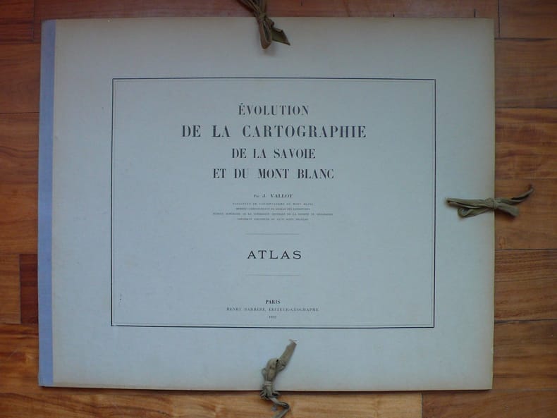
VALLOT Joseph.
EVOLUTION DE LA CARTOGRAPHIE DE LA SAVOIE ET DU MONT BLANC par Joseph Vallot fondateur de l' observatoire du Mont Blanc, membre correspondant du bureau des longitudes, membre honoraire de la Commission centrale de la société de géographie, président d' honneur du CAF.
1922 à Paris 1922. chez H. Barrère. Un Atlas in plano de 26 planches représentant 123 cartes anciennes. et une plaquette in 8 de 32 pages. plaquette à l' état de neuf, non coupée. Atlas en très bon état, cartonnage et intérieur. Quelques minimes taches claires au verso de quelques planches. COMPLET. TRES RARE. tirage à petit nombre.ref. Perret 4409.
書籍販売業者の参照番号
: 2695
|
|
|
Vallot (Joseph ; Lodève 1854 - Nice 1925) :
Florule du Panthéon.
Paris, Mersch, 1887 ; in-8, broché, 4 pp. couverture verte muette.
書籍販売業者の参照番号
: 22281

|
|
|
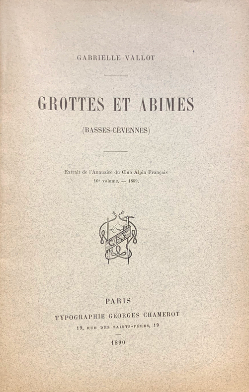
Vallot (Gabrielle) :
Grottes et abimes (Basses Cévennes).
Paris, Georges Chamerot, 1890 ; in-12, broché, 27 pp., couverture imprimée vert-clair, 8 illustrations dont 3 plans de grottes, gravées sur bois.
書籍販売業者の参照番号
: 22292
|
|
|
Vallot (Joseph ; Lodève 1854 - Nice 1925) :
Guide du Botaniste et du géologue dans la région de Cauterets.
Pau, Cazaux ; Paris, Lechevalier, 1886 (Poitiers, Oudin) ; in-16, broché ; XXVIII, 331 pp.
書籍販売業者の参照番号
: 22285

|
|
|
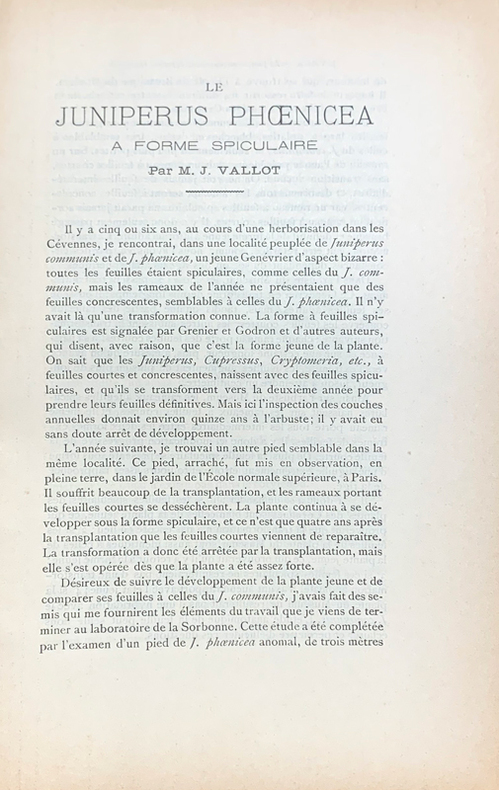
Vallot (Joseph ; Lodève 1854 - Nice 1925) :
Le Juniperus phoenicea à forme spiculaire.
Paris, Mersch, 1888 ; in-8, broché, 9 pp. et couverture verte muette.
書籍販売業者の参照番号
: 22283
|
|
|
Vallot (Joseph ; Lodève 1854 - Nice 1925) :
Plantes recueillies par M. le comte de Clavagnac, entre Fez et Oujdah (Maroc).
Paris, Mersch, 1887 ; in-8, broché, 2 pp., [1bl.] f. et couverture verte muette.
書籍販売業者の参照番号
: 22282
|
|
|
Vallot (Joseph ; Lodève 1854 - Nice 1925) :
Recherches physico-chimiques sur la terre végétale et ses rapports avec la distribution géographique des plantes.
Paris, Librairie médicale et scientifique de Jacques Lechevalier, 1883 ; in-8 broché, XV, 344 pp., couv. grise imprimée.
書籍販売業者の参照番号
: 22291
|
|
|
Valbrune Gérard de
Nell'Arcipelago dei Tifoni (Viaggio alle Filippine)
alcune tavole in bianco e nero fuori testo

|
|
|
Valdrè,Giovanni.
Nomen loci. Per la conservazione della memoria della toponomastica antica e recente di Pratolino.
Approfondita ricerca sui nomi dei luoghi del famoso Parco mediceo, che compaiono ripetutamente nei carteggi dell’Archivio Storico di Villa Demidoff, ma difficilmente identificabili in quanto non raccolti nei cataloghi pubblicati. Gli ultimi custodi della A thorough investigation of the place names of the famous Medicean park, which appear frequently in documents in Villa Demidoff’s historical arch <br/> STATO: NUOVO.<br/> TITOLO: Nomen loci. Per la conservazione della memoria della toponomastica antica e recente di Pratolino. <br/> AUTORE: Valdrè,Giovanni.<br/> EDITORE: Olschki Ed.<br/> DATA ED.: 1999,<br/> COLLANA: Coll.Cultura e memoria,17.<br/> EAN: 9788822247674
|
|
|
VALEGIO Francesco (1570 ca. – 1643 ca.)
Dissegno del Territorio et Stato di Mantova, con gli Stati confinanti cioe Cremonese, Bozolo, Modonese, Guastalla...
Rarissima carta del territorio mantovano basata sul Ducato di Mantova di Giovanni Antonio Magini (1603 circa), ma raffigurante anche i territori circostanti. Si estende a nord dove include Verona e parte del Lago di Garda; ad ovest include Cremona mentre ad est è pressoché identica ed addirittura meno estesa s sud, tagliata poco oltre il confine con i territori di Modena e Mirandola. “Di modesto livello esecutivo, la carta porta la firma dello stampatore lungo il margine inferiore: Stefano Scolari F in Venetia a S Zulian. Stefano Mozzi Scolari è noto per aver stampato contraffazioni e riedizioni di rami già usati da altri, ed è ricordato anche per aver pubblicato alcune carte maginiane più o meno corrette e rimodernate. Tuttavia, questa carta è riconducibile solo indirettamente al modello maginiano; essa comprende un’area più vasta e presenta notevoli diradazioni e contraffazioni nella toponomastica. Ad esempio, Guastalla è stato raschiato dalla posizione originaria, ancora leggibile, e riscritto arbitrariamente poco più a nord-ovest; manca inoltre la graduazione delle coordinate geografiche e il prospetto della città è abbozzato in modo sommario. L’approssimazione esecutiva del prodotto è subordinata ai facili intenti commerciali dello stampatore a scapito della qualità” (D. Ferrari, Mantova nelle stampe, p. 151). Come fa notare la Ferrari, sono presenti nella lastra numerose abrasioni nella toponomastica, indice che Stefano Mozzi Scolari non incise la carta ma utilizzò un rame più antico al quale apportò numerose modifiche. Pertanto, non può essere additato come l'autore della mappa ma solo di questa edizione – un secondo stato – della carta. Numerose le correzioni presenti anche nel cartiglio ornamentale con il titolo, dove si nota una grande abrasione di quello che poteva essere uno stemma nobiliare o un cappello cardinalizio, del dedicatario dell’opera. Lo stile grafico del cartiglio – riconducibile al primo Seicento - ricorda chiaramente quello di altre opere di Francesco Valegio, che per vari motivi ci sembra come il probabile autore di questa mappa. Del resto, Valegio aveva a disposizione diverso materiale cartografico sull’area; non da ultimo era il possessore della lastra della Geografia Particolare della Lombardia (1559) di Giacomo Gastaldi, della quale aveva pubblicato una ristampa all’inizio del ‘600, per poi venderne i rami allo stesso Stefano Mozzi Scolari (cfr. S. Bifolco – F. Ronca, Cartografia e topografia italiana del XVI secolo, 2018, pp. 1858-1859). Sebbene non sia conosciuto nessun esemplare di questa mappa privo dell’indirizzo di Scolari, è altamente probabile che la tesi sopra formulata sia attendibile, anche in relazione al fatto che molte delle lastre di Valegio furono poi acquistate dallo Scolari. Una datazione intorno al 1620 ci sembra consona con le altre mappe del Valegio. Francesco Valegio (Verona 1570 circa – 1650 circa) nasce a Verona da famiglia originaria di Valeggio sul Mincio. Un nucleo si trasferì a Venezia dalla prima metà del Cinquecento. Impossibile verificare sul lacunoso Registro dei battezzati la data di nascita tramandata, 1560, posticipata dal Salsi al 1570; quella di morte è stabilita a dopo il 1650. Definito un vero e proprio “imprenditore dell’immagine”: pittore, disegnatore, incisore, stampatore, editore e, a Venezia, anche venditore di stampe (bottega in Spadaria, al Segno della Sorte), ha prodotto moltissime opere, ritratti, soggetti storici e religiosi, comprese stampe devozionali e illustrazioni per libri, con soggetti altrui o incisi da lui stesso. Pubblicò soprattutto carte geografiche, piante di città (tra quelle venete, Padova e territorio, Vicenza, Verona). Spesso collaborava con altri stampatori, tra questi Catarino Dorino (o Doino) con cui entrò in società e con il quale pubblicò una pianta della città di Venezia nel 1611. Secondo Roberto Almagià, Valegio avrebbe messo in commercio un gran numero ... Very rare map of the Mantuan territory based on the Ducato di Mantova by Giovanni Antonio Magini (c. 1603), but depicting the surrounding territories as well. It extends to the north where it includes Verona and part of Lake Garda; to the west it includes Cremona while to the east it is almost identical and even less extensive south, cut just beyond the border with the territories of Modena and Mirandola. “Di modesto livello esecutivo, la carta porta la firma dello stampatore lungo il margine inferiore: Stefano Scolari F in Venetia a S Zulian. Stefano Mozzi Scolari è noto per aver stampato contraffazioni e riedizioni di rami già usati da altri, ed è ricordato anche per aver pubblicato alcune carte maginiane più o meno corrette e rimodernate. Tuttavia, questa carta è riconducibile solo indirettamente al modello maginiano; essa comprende un’area più vasta e presenta notevoli diradazioni e contraffazioni nella toponomastica. Ad esempio, Guastalla è stato raschiato dalla posizione originaria, ancora leggibile, e riscritto arbitrariamente poco più a nord-ovest; manca inoltre la graduazione delle coordinate geografiche e il prospetto della città è abbozzato in modo sommario. L’approssimazione esecutiva del prodotto è subordinata ai facili intenti commerciali dello stampatore a scapito della qualità” (D. Ferrari, Mantova nelle stampe, p. 151). As Ferrari points out, there are numerous abrasions in the plate in the toponymy, an indication that Stefano Mozzi Scolari did not engrave the map but used an older copper to which he made numerous modifications. Therefore, he cannot be named as the author of the map, but only editor of this edition-a second state-of the map. Numerous corrections are also present in the ornamental cartouche with the title, where there is a large abrasion of what could have been a noble coat of arms or a cardinal's hat, of the dedicatee of the work. The graphic style of the cartouche-which can be traced back to the early seventeenth century-is clearly reminiscent of that of other works by Francesco Valegio, who for various reasons appears to us as the probable author of this map. After all, Valegio had at his disposal various cartographic material on the area; not least, he was the possessor of the plate of Giacomo Gastaldi's Geografia Particolare della Lombardia (1559), of which he had published a reprint in the early 1600s, and then sold the plates to Stefano Mozzi Scolari himself (cf. S. Bifolco – F. Ronca, Cartografia e topografia italiana del XVI secolo, 2018, pp. 1858-1859). Although no specimen of this map without Scolari's address is known, it is highly probable that the above thesis is reliable, also in relation to the fact that many of Valegio's plates were later purchased by Scolari. Francesco Valegio (Verona c. 1570 - c. 1650) was born in Verona to a family originally from Valeggio sul Mincio. A nucleus moved to Venice from the first half of the sixteenth century. Impossible to verify on the lacunose Register of Baptized the date of birth handed down, 1560, postponed by Salsi to 1570; that of death is set to after 1650. Described as a true "entrepreneur of the image": painter, draughtsman, engraver, printer, publisher and, in Venice, also seller of prints (workshop in Spadaria, at the Segno della Sorte), he produced many works, portraits, historical and religious subjects, including devotional prints and illustrations for books, with subjects of others or engraved by himself. He mainly published maps, plans of cities (among those in the Veneto, Padua and its territory, Vicenza, Verona). He often collaborated with other printers, among them Catarino Dorino (or Doino) with whom he entered into partnership and with whom he published a map of the city of Venice in 1611. According to Roberto Almagià, Valegio allegedly marketed a large number of reproductions and forgeries of works by other engravers; in fact-as was the custom at the time-he bought several copperplates of oth...

|
|
|
VALEGIO Francesco (1570 ca. – 1643 ca.)
FRANCE. Nova Haec Tabula Galliae Lodovico XIII Christianis Simo Regi Franciae et Navarrae...
FRANCE. Nova Haec Tabula Galliae Lodovico XIIII Christianis Simo Regi Franciae et Navarrae Humillime Dedicatur a Nicolao Johanni de Visscher Eccellente esemplare di questa misteriosa e raffinata carte-à-figures della Francia, ispirata a Claes Jansz Visscher, e comprendente anche parte delle Fiandre, della Svizzera e dell’Italia, oltre che la raffigurazione delle principali città e borghi. La carta si basa sulla carta della Francia di Claesz Jansz Visscher, pubblicata inizialmente intorno al 1620 (senza data, una seconda edizione viene alla luce nel 1633, e poi ancora ristampata nel 1646, 1653 e 1660). Il titolo FRANCE compare al centro del bordo decorativo superiore, mentre un grande cartiglio con il secondo titolo in nove righe riempie l'angolo inferiore sinistro. In alto a destra si trova un cartiglio con la legenda dei simboli utilizzati sulla carta. La carta è circondata da un bordo decorativo con stemmi, vedute di città e figure in costume. In alto a destra e a sinistra si trovano i ritratti di Luigi XIII (1601- 1643) e della sua consorte Anna Maria Maurizia d'Asburgo (1601 – 1666); differiscono dal prototipo di Visscher, dove sono raffigurati in giovane età, per il fatto che qui compaiono in veste adulta. Si tratta dell’unico aggiornamento “cronologico”; la mappa, per la sua parte cartografica, sembra assolutamente inalterata. Gunther Shilder, nell'introduzione alla sua cartobibliografia delle carte olandesi in folio con bordi decorativi (talvolta definite carte-à-figures, o “carte a pannelli”), ha commentato: “questo genere deve essere considerato uno dei migliori prodotti dell'industria cartografica di Amsterdam. La combinazione vincente tra i progressi delle conoscenze geografiche e l'espressione delle capacità artistiche fece di queste mappe un bene prezioso sia sul mercato nazionale che su quello internazionale” (cfr. Günter Schilder, Monumenta Cartographica Neerlandici VI. "Nederlandse foliokarten met decoratieve randen, 1604-1640”. Il fatto che molte di queste mappe venissero vendute in fogli separati e inserite solo casualmente negli atlanti compositi dell'epoca ne spiega la rarità odierna, mentre il loro fascino estetico non è diminuito nel corso dei secoli, rendendole esempi altamente collezionabili dell'arte cartografica. Questa carta della Francia era ignota a Klaus Stopp, riconosciuto come la maggiore autorità in materia di carte-à-figures. Un esemplare di questa mappa (e di altre anonime carte-à-figures italiane) privo di data ed indicazioni editoriali è stato venduto all’asta, presso Sotheby's Londra, nel novembre del 2008 (lotto 162 e seguenti). Il catalogatore (all’epoca Catherine Slowther, Sotheby’s Senior Specialist), seppure in maniera dubitativa, attribuì la carta a Stefano Mozzi Scolari, datandola al 1642. L’ipotesi, più che attendibile, veniva basata sulla carta utilizzata per la mappa, una carta italiana come documentato dalla presenza della filigrana: “Seven of the maps following are hitherto unrecorded piracies taken from Dutch models by Pieter van den Keere or Jodocus Hondius Jr (re-)published by Johannes Janssonius in the 1630s and 1640s; one feature of the copying process is that the vast majority of the vignettes and costume figures, as also the armorials on the map of Germany, are reversed in engraving so what was on the left in the original now appears on the right. While this is commonly encountered for decorative features in maps, it is incongruous on the London plan, for example, to see the Tower of London placed on the west side of London and Westminster on the east. (However, all the vignettes on the map of France and three on that of Europe – Venice, Rome and Constantinople – are correctly orientated). Although copied from Dutch models, and assuming the engraved dates of 1641 or 1642 are broadly correct for the publication date of the set, it should be noted that the examples of the maps used were not acquired cont... FRANCE. Nova Haec Tabula Galliae Lodovico XIIII Christianis Simo Regi Franciae et Navarrae Humillime Dedicatur a Nicolao Johanni de Visscher Excellent example of this mysterious and refined carte-à-figures of France, inspired by Claes Jansz Visscher, and also including parts of Flanders, Switzerland and Italy, as well as depictions of major cities and towns. The map is based on Claesz Jansz Visscher's map of France, originally published around 1620 (undated, a second edition came to light in 1633, and then again reprinted in 1646, 1653 and 1660). The title FRANCE appears in the center of the upper decorative border, while a large cartouche with the second title in nine lines fills the lower left corner. In the upper right corner is a cartouche with a legend of the symbols used on the map, that is surrounded by a decorative border with coats of arms, city views, and costumed figures. On the upper right and left are portraits of Louis XIII (1601- 1643) and his consort Anne Marie-Maurice of Habsburg (1601 - 1666); they differ from Visscher's prototype, where they are depicted at a young age, in that here they appear in their adult guise. This is the only "chronological" update; the map, for its cartographic part, seems absolutely unchanged. Gunther Shilder, in the introduction to his cartobibliography of Dutch folio maps with decorative borders (sometimes referred to as carte-à-figures, or "panel maps"), commented, "this genre must be regarded as one of the best products of the Amsterdam cartographic industry. The successful combination of advances in geographical knowledge and the expression of artistic skills made these maps a valuable commodity in both the domestic and international markets" (see Günter Schilder, Monumenta Cartographica Neerlandici VI. "Nederlandse foliokarten met decoratieve randen, 1604-1640." The fact that many of these maps were sold in separate sheets and included only casually in the composite atlases of the time explains their rarity today, while their aesthetic appeal has not diminished over the centuries, making them highly collectible examples of cartographic art. This map of France was unknown to Klaus Stopp, recognized as the foremost authority on carte-à-figures. A specimen of this map (and other anonymous Italian carte-à-figures) devoid of date and editorial indications was sold at auction, at Sotheby's London, in November 2008 (lot 162 et seq.). The cataloguer (at the time Catherine Slowther, Sotheby's Senior Specialist), albeit dubiously, attributed the map to Stefano Mozzi Scolari, dating it to about 1642. The hypothesis, more than reliable, was based on the paper used for the map, an Italian map as documented by the presence of the watermark: “Seven of the maps following are hitherto unrecorded piracies taken from Dutch models by Pieter van den Keere or Jodocus Hondius Jr (re-)published by Johannes Janssonius in the 1630s and 1640s; one feature of the copying process is that the vast majority of the vignettes and costume figures, as also the armorials on the map of Germany, are reversed in engraving so what was on the left in the original now appears on the right. While this is commonly encountered for decorative features in maps, it is incongruous on the London plan, for example, to see the Tower of London placed on the west side of London and Westminster on the east. (However, all the vignettes on the map of France and three on that of Europe – Venice, Rome and Constantinople – are correctly orientated). Although copied from Dutch models, and assuming the engraved dates of 1641 or 1642 are broadly correct for the publication date of the set, it should be noted that the examples of the maps used were not acquired contemporaneously; the maps of the continents, for example were issued by Janssonius in 1632 with the lower panel removed. It is possible that these maps were engraved in Venice (the plan of Venice being one of the few vignette insets correctly orientate...

|
|
|
VALEGIO Francesco (1570 ca. – 1643 ca.)
Italiae, Sardiniae, Corsicae et confinium Regionum nova Tabula....
Italiae, Sardiniae, Corsicae et confinium Regionum nova Tabula effigies praecipuarum Urbiu[m] et habituum inibi sinul co[m]plectens Eccellente carte-à-figures della penisola italiana, riccamente decorata con la raffigurazione delle principali città e borghi e con i costumi tipici della nazione. Gunther Shilder, nell'introduzione alla sua cartobibliografia delle carte olandesi in folio con bordi decorativi (talvolta definite carte-à-figures, o “carte a pannelli”), ha commentato: “questo genere deve essere considerato uno dei migliori prodotti dell'industria cartografica di Amsterdam. La combinazione vincente tra i progressi delle conoscenze geografiche e l'espressione delle capacità artistiche fece di queste mappe un bene prezioso sia sul mercato nazionale che su quello internazionale” (cfr. Günter Schilder, Monumenta Cartographica Neerlandici VI. "Nederlandse foliokarten met decoratieve randen, 1604-1640”. Il fatto che molte di queste mappe venissero vendute in fogli separati e inserite solo casualmente negli atlanti compositi dell'epoca ne spiega la rarità odierna, mentre il loro fascino estetico non è diminuito nel corso dei secoli, rendendole esempi altamente collezionabili dell'arte cartografica. Questa carta dell’Italia era ignota a Klaus Stopp, riconosciuto come la maggiore autorità in materia di carte-à-figures. Un esemplare di questa mappa - oggi conservato presso una prestigiosa collezione privata - privo di data ed indicazioni editoriali fu venduto prima di finire all’asta, dove, presso Sotheby's Londra altre anonime carte-à-figures di produzione italiana della stessa tipologia vennero poste all’incanto nel novembre del 2008 (lotto 162 e seguenti). Il catalogatore (all’epoca Catherine Slowther, Sotheby’s Senior Specialist), seppure in maniera dubitativa, attribuì la carta a Stefano Mozzi Scolari, datandola al 1642 circa. L’ipotesi, più che attendibile, veniva basata sulla carta utilizzata per la mappa, una carta italiana come documentato dalla presenza della filigrana: “Seven of the maps following are hitherto unrecorded piracies taken from Dutch models by Pieter van den Keere or Jodocus Hondius Jr (re-)published by Johannes Janssonius in the 1630s and 1640s; one feature of the copying process is that the vast majority of the vignettes and costume figures, as also the armorials on the map of Germany, are reversed in engraving so what was on the left in the original now appears on the right. While this is commonly encountered for decorative features in maps, it is incongruous on the London plan, for example, to see the Tower of London placed on the west side of London and Westminster on the east. (However, all the vignettes on the map of France and three on that of Europe – Venice, Rome and Constantinople – are correctly orientated). Although copied from Dutch models, and assuming the engraved dates of 1641 or 1642 are broadly correct for the publication date of the set, it should be noted that the examples of the maps used were not acquired contemporaneously; the maps of the continents, for example were issued by Janssonius in 1632 with the lower panel removed. It is possible that these maps were engraved in Venice (the plan of Venice being one of the few vignette insets correctly orientated), perhaps by the little known publisher Stefano Scolari, who is known to have published other maps from Dutch originals, but as the maps are without any engraved attribution, this must be speculative. That the paper used in printing was too small for the printing plates may, however, point to a bookseller rather than map- or print-seller. Five of the maps have watermarks showing an anchor in a circle, surmounted by a six-pointed star (Heawood 8?) which indicates the paper to be Italian and of the period”. Il nostro esemplare – un secondo stato della lastra - presenta interventi di ritocco per la ristampa. Nel cartiglio con il titolo, viene aggiunta la firma Stefa... Italiae, Sardiniae, Corsicae et confinium Regionum nova Tabula effigies praecipuarum Urbiu[m] et habituum inibi sinul co[m]plectens Excellent carte-à-figures of the Italian peninsula, richly decorated with depictions of the main cities and towns and typical costumes of the nation. Gunther Shilder, in the introduction to his cartobibliography of Dutch folio maps with decorative borders (sometimes referred to as carte-à-figures, or "panel maps"), commented, "this genre must be regarded as one of the best products of the Amsterdam cartographic industry. The successful combination of advances in geographical knowledge and the expression of artistic skills made these maps a valuable commodity in both the domestic and international markets" (see Günter Schilder, Monumenta Cartographica Neerlandici VI. "Nederlandse foliokarten met decoratieve randen, 1604-1640." The fact that many of these maps were sold in separate sheets and included only casually in the composite atlases of the time explains their rarity today, while their aesthetic appeal has not diminished over the centuries, making them highly collectible examples of cartographic art. This map of Italy was unknown to Klaus Stopp, recognized as the foremost authority on carte-à-figures. A specimen of this map (and other anonymous Italian carte-à-figures) devoid of date and editorial indications was sold at auction, at Sotheby's London, in November 2008 (lot 162 et seq.). The cataloguer (at the time Catherine Slowther, Sotheby's Senior Specialist), albeit dubiously, attributed the map to Stefano Mozzi Scolari, dating it to about 1642. The hypothesis, more than reliable, was based on the paper used for the map, an Italian map as documented by the presence of the watermark: “Seven of the maps following are hitherto unrecorded piracies taken from Dutch models by Pieter van den Keere or Jodocus Hondius Jr (re-)published by Johannes Janssonius in the 1630s and 1640s; one feature of the copying process is that the vast majority of the vignettes and costume figures, as also the armorials on the map of Germany, are reversed in engraving so what was on the left in the original now appears on the right. While this is commonly encountered for decorative features in maps, it is incongruous on the London plan, for example, to see the Tower of London placed on the west side of London and Westminster on the east. (However, all the vignettes on the map of France and three on that of Europe – Venice, Rome and Constantinople – are correctly orientated). Although copied from Dutch models, and assuming the engraved dates of 1641 or 1642 are broadly correct for the publication date of the set, it should be noted that the examples of the maps used were not acquired contemporaneously; the maps of the continents, for example were issued by Janssonius in 1632 with the lower panel removed. It is possible that these maps were engraved in Venice (the plan of Venice being one of the few vignette insets correctly orientated), perhaps by the little known publisher Stefano Scolari, who is known to have published other maps from Dutch originals, but as the maps are without any engraved attribution, this must be speculative. That the paper used in printing was too small for the printing plates may, however, point to a bookseller rather than map- or print-seller. Five of the maps have watermarks showing an anchor in a circle, surmounted by a six-pointed star (Heawood 8?) which indicates the paper to be Italian and of the period”. Our copy - a second state of the plate - has been retouched for reprinting. In the title cartouche, is added to the signature Stefano Scolari Forma in Venetia. The fact certifies that the attribution was plausible. However, the hypothesis that seems most possible to us, that the author of the map can be traced back to Francesco Valegio. After all, it is widely documented how Scolari came into possession of a large number of Valegio's plates, reprinting...

|
|
|
VALEGIO Francesco (1570 ca. – 1643 ca.)
Nova Germaniae Descriptio
Nova Germaniae descriptio... Amstelodami apud Ioannem Ianssoniu[m] anno 1660. Eccellente carte-à-figures della Germania, comprendente anche parte delle Fiandre e di Svizzera, Italia, Polonia, Boemia e Ungheria, oltre che la raffigurazione delle principali città e borghi. Si tratta di una copia pirata della mappa di Pieter van der Keere (Kaerius) del 1615, esattamente della sua terza edizione pubblicta nel 1631 da Johannes Janssonius (cfr. Schilder MCN, VI, n. 33.3). Le vignette lungo i margini destro e sinistro raffigurano diversi modelli regionali e sociali, mentre quelle lungo i margini superiore e inferiore raffigurano vedute e piante delle città tedesche situate lungo i confini. Nel margine superiore è inserito anche un ritratto equestre di Ferdinando II, Santo Imperatore Romano e Re di Boemia, insieme ad altri duchi e arcivescovi con i loro rispettivi stemmi araldici nella parte superiore. Gunther Shilder, nell'introduzione alla sua cartobibliografia delle carte olandesi in folio con bordi decorativi (talvolta definite carte-à-figures, o “carte a pannelli”), ha commentato: “questo genere deve essere considerato uno dei migliori prodotti dell'industria cartografica di Amsterdam. La combinazione vincente tra i progressi delle conoscenze geografiche e l'espressione delle capacità artistiche fece di queste mappe un bene prezioso sia sul mercato nazionale che su quello internazionale” (cfr. Günter Schilder, Monumenta Cartographica Neerlandici VI. "Nederlandse foliokarten met decoratieve randen, 1604-1640”. Il fatto che molte di queste mappe venissero vendute in fogli separati e inserite solo casualmente negli atlanti compositi dell'epoca ne spiega la rarità odierna, mentre il loro fascino estetico non è diminuito nel corso dei secoli, rendendole esempi altamente collezionabili dell'arte cartografica. Questa carta della Germania era ignota a Klaus Stopp, riconosciuto come la maggiore autorità in materia di carte-à-figures. Un esemplare di questa mappa (e di altre anonime carte-à-figures italiane) privo di data ed indicazioni editoriali è stato venduto all’asta, presso Sotheby's Londra, nel novembre del 2008 (lotto 162 e seguenti). Il catalogatore (all’epoca Catherine Slowther, Sotheby’s Senior Specialist), seppure in maniera dubitativa, attribuì la carta a Stefano Mozzi Scolari, datandola al 1642 circa. L’ipotesi, più che attendibile, veniva basata sulla carta utilizzata per la mappa, una carta italiana come documentato dalla presenza della filigrana: “Seven of the maps following are hitherto unrecorded piracies taken from Dutch models by Pieter van den Keere or Jodocus Hondius Jr (re-)published by Johannes Janssonius in the 1630s and 1640s; one feature of the copying process is that the vast majority of the vignettes and costume figures, as also the armorials on the map of Germany, are reversed in engraving so what was on the left in the original now appears on the right. While this is commonly encountered for decorative features in maps, it is incongruous on the London plan, for example, to see the Tower of London placed on the west side of London and Westminster on the east. (However, all the vignettes on the map of France and three on that of Europe – Venice, Rome and Constantinople – are correctly orientated). Although copied from Dutch models, and assuming the engraved dates of 1641 or 1642 are broadly correct for the publication date of the set, it should be noted that the examples of the maps used were not acquired contemporaneously; the maps of the continents, for example were issued by Janssonius in 1632 with the lower panel removed. It is possible that these maps were engraved in Venice (the plan of Venice being one of the few vignette insets correctly orientated), perhaps by the little known publisher Stefano Scolari, who is known to have published other maps from Dutch originals, but as the maps are without any engraved attribution, this must be speculative. ... Excellent map-à-figures of Germany, also including parts of Flanders and Switzerland, Italy, Poland, Bohemia and Hungary, as well as depictions of major cities and towns. This is a pirated copy of Pieter van der Keere's (Kaerius) map of 1615, exactly its third edition published in 1631 by Johannes Janssonius (see Schilder MCN, VI, no. 33.3). The vignettes along the left and right margins depict various regional and social patterns, while those along the upper and lower margins depict views and plans of German cities located along the borders. Also included in the upper margin is an equestrian portrait of Ferdinand II, Holy Roman Emperor and King of Bohemia, along with other dukes and archbishops with their respective heraldic coats of arms at the top. Gunther Shilder, in the introduction to his cartobibliography of Dutch folio maps with decorative borders (sometimes referred to as carte-à-figures, or "panel maps"), commented, "this genre must be regarded as one of the best products of the Amsterdam cartographic industry. The successful combination of advances in geographical knowledge and the expression of artistic skills made these maps a valuable commodity in both the domestic and international markets" (see Günter Schilder, Monumenta Cartographica Neerlandici VI. "Nederlandse foliokarten met decoratieve randen, 1604-1640." The fact that many of these maps were sold in separate sheets and included only casually in the composite atlases of the time explains their rarity today, while their aesthetic appeal has not diminished over the centuries, making them highly collectible examples of cartographic art. This map of Germany was unknown to Klaus Stopp, recognized as the foremost authority on carte-à-figures. A specimen of this map (and other anonymous Italian carte-à-figures) devoid of date and editorial indications was sold at auction, at Sotheby's London, in November 2008 (lot 162 et seq.). The cataloguer (at the time Catherine Slowther, Sotheby's Senior Specialist), albeit dubiously, attributed the map to Stefano Mozzi Scolari, dating it to about 1642. The hypothesis, more than reliable, was based on the paper used for the map, an Italian map as documented by the presence of the watermark: “Seven of the maps following are hitherto unrecorded piracies taken from Dutch models by Pieter van den Keere or Jodocus Hondius Jr (re-)published by Johannes Janssonius in the 1630s and 1640s; one feature of the copying process is that the vast majority of the vignettes and costume figures, as also the armorials on the map of Germany, are reversed in engraving so what was on the left in the original now appears on the right. While this is commonly encountered for decorative features in maps, it is incongruous on the London plan, for example, to see the Tower of London placed on the west side of London and Westminster on the east. (However, all the vignettes on the map of France and three on that of Europe – Venice, Rome and Constantinople – are correctly orientated). Although copied from Dutch models, and assuming the engraved dates of 1641 or 1642 are broadly correct for the publication date of the set, it should be noted that the examples of the maps used were not acquired contemporaneously; the maps of the continents, for example were issued by Janssonius in 1632 with the lower panel removed. It is possible that these maps were engraved in Venice (the plan of Venice being one of the few vignette insets correctly orientated), perhaps by the little known publisher Stefano Scolari, who is known to have published other maps from Dutch originals, but as the maps are without any engraved attribution, this must be speculative. That the paper used in printing was too small for the printing plates may, however, point to a bookseller rather than map- or print-seller. Five of the maps have watermarks showing an anchor in a circle, surmounted by a six-pointed star (Heawood 8?) which indicates the paper to be Italian and ...

|
|
|
VALEGIO Francesco (1570 ca. – 1643 ca.)
Nova Hispaniae Descriptio
Eccellente carte-à-figures della Spagna (Penisola Iberica), riccamente decorata con la raffigurazione delle principali città e borghi e con i costumi tipici della nazione. La carta si basa sulla carta della Spagna di Pieter van den Keere pubblicata inizialmente nel 1616. Il titolo e l'imprint sono riuniti in un cartiglio in basso a destra, sotto il quale si trova una veduta di Madrid. In alto a destra si trova un semplice cartiglio con due barre di scala e una legenda con i simboli utilizzati sulla carta. L'immagine della carta è incorniciata da scale latitudinali e longitudinali; meridiani e paralleli sono disegnati ad ogni grado completo. La carta è circondata da vedute sul bordo superiore e inferiore, con un ritratto di Filippo IV e lo stemma della Spagna e figure ai lati. La carta fu successivamente acquistata da Johannes Janssonius che la ripubblicò con figure diverse nel 1626 e di nuovo nel 1632 (Schilder, Monumenta Cartographica, VI, 101.3). È su quest'ultimo stato che si basa la presente carta che, tuttavia, presenta tutte le figure e le vedute della bordura invertite; ad esempio, la veduta di Valladolid, che sull’originale è in alto a destra, in questa mappa finisce in alto a sinistra. Gunther Shilder, nell'introduzione alla sua cartobibliografia delle carte olandesi in folio con bordi decorativi (talvolta definite carte-à-figures, o “carte a pannelli”), ha commentato: “questo genere deve essere considerato uno dei migliori prodotti dell'industria cartografica di Amsterdam. La combinazione vincente tra i progressi delle conoscenze geografiche e l'espressione delle capacità artistiche fece di queste mappe un bene prezioso sia sul mercato nazionale che su quello internazionale” (cfr. Günter Schilder, Monumenta Cartographica Neerlandici VI. "Nederlandse foliokarten met decoratieve randen, 1604-1640”. Il fatto che molte di queste mappe venissero vendute in fogli separati e inserite solo casualmente negli atlanti compositi dell'epoca ne spiega la rarità odierna, mentre il loro fascino estetico non è diminuito nel corso dei secoli, rendendole esempi altamente collezionabili dell'arte cartografica. Questa carta della Spagna era ignota a Klaus Stopp, riconosciuto come la maggiore autorità in materia di carte-à-figures. Un esemplare di questa mappa (e di altre anonime carte-à-figures italiane) privo di data ed indicazioni editoriali è stato venduto all’asta, presso Sotheby's Londra, nel novembre del 2008 (lotto 162 e seguenti). Il catalogatore (all’epoca Catherine Slowther, Sotheby’s Senior Specialist), seppure in maniera dubitativa, attribuì la carta a Stefano Mozzi Scolari, datandola al 1642 circa. L’ipotesi, più che attendibile, veniva basata sulla carta utilizzata per la mappa, una carta italiana come documentato dalla presenza della filigrana: “Seven of the maps following are hitherto unrecorded piracies taken from Dutch models by Pieter van den Keere or Jodocus Hondius Jr (re-)published by Johannes Janssonius in the 1630s and 1640s; one feature of the copying process is that the vast majority of the vignettes and costume figures, as also the armorials on the map of Germany, are reversed in engraving so what was on the left in the original now appears on the right. While this is commonly encountered for decorative features in maps, it is incongruous on the London plan, for example, to see the Tower of London placed on the west side of London and Westminster on the east. (However, all the vignettes on the map of France and three on that of Europe – Venice, Rome and Constantinople – are correctly orientated). Although copied from Dutch models, and assuming the engraved dates of 1641 or 1642 are broadly correct for the publication date of the set, it should be noted that the examples of the maps used were not acquired contemporaneously; the maps of the continents, for example were issued by Janssonius in 1632 with the lower panel removed. It is possible that these m... Excellent carte-à-figures of Spain (Iberian Peninsula), richly decorated with depictions of the main cities and towns and typical costumes of the nation. The map is based on Pieter van den Keere's map of Spain originally published in 1616. The title and imprint are brought together in a cartouche at the lower right, below which is a view of Madrid. In the upper right is a simple cartouche with two scale bars and a legend with the symbols used. The map image is framed by latitudinal and longitudinal scales; meridians and parallels are drawn at each full degree. The chart is surrounded by views on the top and bottom edges, with a portrait of Philip IV and the coat of arms of Spain and figures on either side. The map was later acquired by Johannes Janssonius, who republished it with different figures in 1626 and again in 1632 (Schilder, Monumenta Cartographica, VI, 101.3). It is on the latter state that the present map is based, which, however, has all the figures and views of the bordure reversed; for example, the view of Valladolid, which on the original is on the upper right, ends up on the upper left in this map. Gunther Shilder, in the introduction to his cartobibliography of Dutch folio maps with decorative borders (sometimes referred to as carte-à-figures, or "panel maps"), commented, "this genre must be regarded as one of the best products of the Amsterdam cartographic industry. The successful combination of advances in geographical knowledge and the expression of artistic skills made these maps a valuable commodity in both the domestic and international markets" (see Günter Schilder, Monumenta Cartographica Neerlandici VI. "Nederlandse foliokarten met decoratieve randen, 1604-1640." The fact that many of these maps were sold in separate sheets and included only casually in the composite atlases of the time explains their rarity today, while their aesthetic appeal has not diminished over the centuries, making them highly collectible examples of cartographic art. This map of Spain was unknown to Klaus Stopp, recognized as the foremost authority on carte-à-figures. A specimen of this map (and other anonymous Italian carte-à-figures) devoid of date and editorial indications was sold at auction, at Sotheby's London, in November 2008 (lot 162 et seq.). The cataloguer (at the time Catherine Slowther, Sotheby's Senior Specialist), albeit dubiously, attributed the map to Stefano Mozzi Scolari, dating it to about 1642. The hypothesis, more than reliable, was based on the paper used for the map, an Italian map as documented by the presence of the watermark: “Seven of the maps following are hitherto unrecorded piracies taken from Dutch models by Pieter van den Keere or Jodocus Hondius Jr (re-)published by Johannes Janssonius in the 1630s and 1640s; one feature of the copying process is that the vast majority of the vignettes and costume figures, as also the armorials on the map of Germany, are reversed in engraving so what was on the left in the original now appears on the right. While this is commonly encountered for decorative features in maps, it is incongruous on the London plan, for example, to see the Tower of London placed on the west side of London and Westminster on the east. (However, all the vignettes on the map of France and three on that of Europe – Venice, Rome and Constantinople – are correctly orientated). Although copied from Dutch models, and assuming the engraved dates of 1641 or 1642 are broadly correct for the publication date of the set, it should be noted that the examples of the maps used were not acquired contemporaneously; the maps of the continents, for example were issued by Janssonius in 1632 with the lower panel removed. It is possible that these maps were engraved in Venice (the plan of Venice being one of the few vignette insets correctly orientated), perhaps by the little known publisher Stefano Scolari, who is known to have published other maps from Dutch originals, but as ...

|
|
|
VALEGIO Francesco (1570 ca. – 1643 ca.)
Segna
Acquaforte e bulino, 1616, firmata in lastra in basso a destra Franc.co Valegio forma. Esemplare di secondo stato, con imprint Stefano Scolari forma in Venetia a S. Zulian. Pianta prospettica della città fortificata di Senja (Senj) che si trova sulla costa della Croazia tra Rijeka-Fiume e Zara. Sovrasta la città la fortezza di Nehaj, si trova in direzione sud dal Porto, fuori le mura. Venne costruita nel 1558 quando Venezia e i Turchi erano all'apice del loro potere ed è alta 18m e larga 23m. Nella dedica al senatore veneziano Antonio Bragadin, nel cartiglio in alto al centro, il Valegio dichiara di essersi servito di un disegno di Zaccaria dal Pozzo, un medico di Feltre morto a 102 anni nel 1561. Probabile che il disegno non contenesse la fortezza – presente invece nell’incisione – che fu costruita solo nel 1558. Francesco Valegio (Valesio o Valeggio), nato a Verona da famiglia originaria di Valeggio sul Mincio (Verona). Definito un vero e proprio “imprenditore dell’immagine”: pittore, disegnatore, incisore, stampatore, editore e, a Venezia, anche venditore di stampe (bottega in Spadaria, al Segno della Sorte), ha prodotto moltissime opere, ritratti, soggetti storici e religiosi, comprese stampe devozionali e illustrazioni per libri e numerose carte geografiche. Stefano Mozzi Scolari, incisore e editore bresciano, è attivo a Venezia dal 1644 al 1687. La sua bottega era una delle migliori calcografie veneziane del ‘600. Esercitò l’arte delle stampe e del commercio di carte geografiche a S. Zulian all’insegna delle Tre Virtu. Si servì dei rami di Bertelli, Valegio e Van Aelst, curando anche le ristampe di importantissime carte quali la Lombardia del Gastaldi, e le carte dell’Italia di Greuter e Magini. L’opera è di grandissima rarità. Un esemplare è noto nella ex collezione di Franco Novacco; un altro è descritto da Marinelli nella raccolta del Museo Civico Correr. Magnifica prova, impressa su carta vergata coeva, con margini, in perfetto stato di conservazione. Bibliografia Marinelli, Saggio di cartografia veneta, n. 685. Etching and engraving, 1616, signed in plate at lower right Franc.co Valegio forma. Exemple of the second state, with the imprint Stefano Scolari forma in Venetia a S. Zulian. Perspective plan of the fortified city of Senja (Senj), located on the Croatian coast between Rijeka and Zadar. Overlooking the city is the fortress of Nehaj, which is located south of the Port, outside the walls. It was built in 1558 when Venice and the Turks were at the height of their power and is 18m high and 23m wide. In the dedication to the Venetian senator Antonio Bragadin, in the scroll at the top center, Valegio states that he used a drawing by Zaccaria dal Pozzo, a doctor from Feltre who died at the age of 102 in 1561. It is likely that the drawing did not contain the fortress - present instead in the engraving - which was built only in 1558. Francesco Valegio (Valesio or Valeggio), born in Verona to a family originally from Valeggio sul Mincio (Verona). Defined a true "entrepreneur of the image": painter, draftsman, engraver, printer, publisher and, in Venice, also seller of prints (workshop in Spadaria, at the Segno della Sorte), he produced many works, portraits, historical and religious subjects, including devotional prints and illustrations for books and numerous maps. Stefano Mozzi Scolari, engraver and publisher from Brescia, was active in Venice from 1644 to 1687. His workshop was one of the best Venetian chalcography of the '600. He practiced the art of printing and trading maps in S. Zulian at the sign of the Three Virtues. He used the plates of Bertelli, Valegio and Van Aelst, also taking care of the reprinting of very important maps such as Gastaldi's Lombardia, and the maps of Italy by Greuter and Magini. The work is extremely rare. One example is known in the former collection of Franco Novacco; another one is described by Marinelli in the collection of the Museo Civico Correr. Magnificent proof, printed on contemporary laid paper, with margins, in perfect condition. Bibliography Marinelli, Saggio di cartografia veneta, n. 685. Marinelli, Saggio di cartografia veneta, n. 685.

|
|
|
VALENTI PAOLA - VALERIO VLADIMIRO
APPARATI DECORATIVI. Figurazioni e decorazioni nella cartografia italiana dal '400 all'800.
Bross.con cop. ill., cm 24x23, pp 142, 54 tavv. in b/n..
|
|
|
Valentini Norberto
Il dramma di due comunisti a Mosca
numerose foto in bianco e nero su tavole fuori testo

|
|
|
VALERIO V.
L'ITALIA E LE SUE REGIONI NELLA BOTTEGA DELL'INCISORE. Venezia e Roma nel '500. Catalogo ragionato delle tavole cartografiche e note biografiche. Mostra cartografica, Sant'Anatolia di Narco (PG), Chiesa Madonna delle Grazie, 30 maggio - 1 giugno 2008.
Bross., cm 24x21, pp 140, 44 tavv. in b/n.
|
|
|
Valerio Vladimiro
L'Italia prima dell'Italia. Carte geografiche e topografiche dell'Italia dal 1478 al 1861. Caserta, 14 settembre - 1 ottobre 2011.
Bross., cm 24x23, pp 155, molte tavv. a col.. - ISBN: 9788887867350

|
|
|
VALERIO Vladimiro -
Atlanti italiani dal XV al XVII secolo.
Firenze, 1999, 8vo stralcio con copertina posticcia muta, pp. 103/132 con illustrazioni e carte in nero ed una carta a colori a colori. - !! ATTENZIONE !!: Con il termine estratto (o stralcio) intendiamo riferirci ad un fascicolo contenente un articolo, completo in se, sia che esso sia stato stampato a parte utilizzando la stessa composizione sia che provenga direttamente da una rivista. Le pagine sono indicate come "da/a", ad esempio: 229/231 significa che il testo è composto da tre pagine. Quando la rivista di provenienza non viene indicata é perché ci è sconosciuta. - !! ATTENTION !!: : NOT A BOOK : “extract” or “excerpt” means simply a few pages, original nonetheless, printed in a magazine. Pages are indicated as in "from” “to", for example: 229/231 means the text comprises three pages (229, 230 and 231). If the magazine that contained the pages is not mentioned, it is because it is unknown to us.

|
|
|
VALERIO Vladimiro -
Contributo alla storia della carta d'Italia e della Sicilia. Una inedita sintesi cartografica tra il XVIII ed il XIX secolo.
Firenze, 1983, 8vo stralcio con copertina posticcia muta, pp. 105/126 con 9 carte (di cui una a colori e due a pagina doppia) . - !! ATTENZIONE !!: Con il termine estratto (o stralcio) intendiamo riferirci ad un fascicolo contenente un articolo, completo in se, sia che esso sia stato stampato a parte utilizzando la stessa composizione sia che provenga direttamente da una rivista. Le pagine sono indicate come "da/a", ad esempio: 229/231 significa che il testo è composto da tre pagine. Quando la rivista di provenienza non viene indicata é perché ci è sconosciuta. - !! ATTENTION !!: : NOT A BOOK : “extract” or “excerpt” means simply a few pages, original nonetheless, printed in a magazine. Pages are indicated as in "from” “to", for example: 229/231 means the text comprises three pages (229, 230 and 231). If the magazine that contained the pages is not mentioned, it is because it is unknown to us.

|
|
|
VALERIO Vladimiro -
Mercato e cultura nella produzione di atlanti in Italia tra il XVIII ed il XIX secolo.
Firenze, 1990, 8vo stralcio con copertina posticcia muta, pp. 298/353 con numerose illustrazioni e carte in nero e a colori. - !! ATTENZIONE !!: Con il termine estratto (o stralcio) intendiamo riferirci ad un fascicolo contenente un articolo, completo in se, sia che esso sia stato stampato a parte utilizzando la stessa composizione sia che provenga direttamente da una rivista. Le pagine sono indicate come "da/a", ad esempio: 229/231 significa che il testo è composto da tre pagine. Quando la rivista di provenienza non viene indicata é perché ci è sconosciuta. - !! ATTENTION !!: : NOT A BOOK : “extract” or “excerpt” means simply a few pages, original nonetheless, printed in a magazine. Pages are indicated as in "from” “to", for example: 229/231 means the text comprises three pages (229, 230 and 231). If the magazine that contained the pages is not mentioned, it is because it is unknown to us.

|
|
|
VALERIO Vladimiro -
Topografi piemontesi nell'Italia unita.
Firenze, 1996, 8vo stralcio con copertina posticcia muta, pp. 97/128 con numerose carte, in nero e a colori. - !! ATTENZIONE !!: Con il termine estratto (o stralcio) intendiamo riferirci ad un fascicolo contenente un articolo, completo in se, sia che esso sia stato stampato a parte utilizzando la stessa composizione sia che provenga direttamente da una rivista. Le pagine sono indicate come "da/a", ad esempio: 229/231 significa che il testo è composto da tre pagine. Quando la rivista di provenienza non viene indicata é perché ci è sconosciuta. - !! ATTENTION !!: : NOT A BOOK : “extract” or “excerpt” means simply a few pages, original nonetheless, printed in a magazine. Pages are indicated as in "from” “to", for example: 229/231 means the text comprises three pages (229, 230 and 231). If the magazine that contained the pages is not mentioned, it is because it is unknown to us.

|
|
|
Valerio Vladimiro a cura di
L'Italia prima dell'Italia Carte geografiche e topografiche dell'Italia dal 1478 al 1861
in 8° quadrato, bross. edit. ill. con bandelle

|
|
|
Valerio Vladimiro; Spagnolo Santo
Sicilia 1477-1861. La collezione Spagnolo-Patermo in quattro secoli di cartografia
ill., ril. tela Le vicende della Sicilia sono state sempre collegate ai principali avvenimenti europei, ecco perché una lettura a più livelli d'indagine delle sue rappresentazioni cartografiche permette di leggere in filigrana l'intera storia della cultura occidentale. Questa pubblicazione nasce con l'intento di mettere ordine nell'enorme produzione cartografica a stampa sulla Sicilia, mai integralmente schedata prima d'ora, descrivendo oltre 300 mappe dell'isola prodotte tra il 1477, prima carta della Sicilia a stampa, e il 1861, data dell'Unità d'Italia e di nascita di un istituto topografico nazionale che rileverà e disegnerà l'isola in ogni più minuto dettaglio. Sette saggi introduttivi, scritti da esperti nelle varie materie trattate che vanno dalla tradizione geografica di Tolomeo, all'incisione tra Venezia e Roma nel '500, agli Isolari etc., introducono il 'viaggiatore' alla lettura multipla di questi affascinanti documenti grafici.

|
|
|
Valkenburg Samuel Van Cartography By Franklin C Erickson
Elements of Political Geography critical/practical Study techniques Methods Explained Units Regions states
Prentice Hall 1940 This book is used and has some rubbing on the covers edges and spine. Excellent source for study. Poignent research material for students and academics. This book is a practical guide for students laymen or enthusiasts covering theory history terminology and general information. Convenient handbook for reference and self study. Provides an in depth selection of topics and review written in clear everyday English for futher clarity. P: previous Owner name/marks/minor Stain. 3: Hard Cover / Embossed. A: Book in Good or Better Cond/No Dust Jacket. Illus. by Illustrated with maps/graphs or Charts. S: Some Edgewear Normal for Age of Book. History Culture Politics. Prentice Hall, 1940 Hardcover
書籍販売業者の参照番号
: 5015143

|
|
|
VALLARDI, ANTONIO.
Lazio (Provincia di Roma). Carta corografica stradale.
Antonio Vallardi, 1901. Dalla serie di cartine "L'Italia divisa in regioni". Grande carta ripiegata dentro astuccio in carta, cm 55 x 70,5, stampata in colore. La carta si estende da Roccastrada e Grosseto a nord, a Gaeta, Isernia e il Volturno a sud. Consuete pieghe editoriali, possibili difetti marginali e di copertina, in ottimo stato di conservazione la carta all'interno.

|
|
|
VALLARDI, FRANCESCO - BERTOTTI, PIETRO.
Profilo geometrico della Parte Occidentale delle Alpi Retiche. Dal Colle di S. Bernardino fino al Monte Ortles.
ratta dall' “Atlante Geografico dell'Italia”, Milano, Francesco Vallardi, 1880 circa. Litografia a doppia pagina (Litografia di Pietro Bertotti), colore d'epoca, cm 46,8 x 66,5 (la parte figurata) più margini. Tavola raffigurante il profilo geometrico della parte orientale delle Alpi Retiche, con estensione dal Colledi San Bernardino al Monte Ortles e in cui si distinguono le vette principali e le secondarie. Buon esemplare.

|
|
|
VALLARDI, FRANCESCO – BERTOTTI, PIETRO.
Profilo geometrico della Parte Orientale delle Alpi Retiche. Dal Monte Ortles fino al Picco dei Tre Signori o Drey – Herren – Spitz.
Tratta dall' “Atlante Geografico dell'Italia”, Milano, Francesco Vallardi, 1880 circa. Litografia a doppia pagina (Litografia di Pietro Bertotti), colore d'epoca, cm 46,5 x 67 (la parte figurata) più margini. Tavola raffigurante il profilo geometrico della parte orientale delle Alpi Retiche, con estensione dal Monte Ortler fino al Pizzo dei Tre Signori e in cui si distinguono le vette principali e le secondarie. Buon esemplare.

|
|
|
VALLARDI, FRANCESCO.
Carta moderna delle Province Venete.
Tratta dall' “Atlante Geografico dell'Italia” Milano, Francesco Vallardi, 1880 circa. Incisione a doppia pagina, b/n (confini in colore d'epoca), cm 53,3 x 67,3 (la parte figurata) più margini. In basso, entro riquadro, il Prospetto delle Province Venete. La carta deriva da quella pubblicata a Firenze da Attilio Zuccagni Orlandini nel 1844, rispetto alla quale è aggiornata. Ingiallimento della brachetta centrale, peraltro buon esemplare.

|
|
|
VALLARDI, FRANCESCO.
Circondario di Fuligno e di Perugia.
Tratta dall' “Atlante Geografico dell'Italia” Milano, Francesco Vallardi, 1880 circa. Incisione, b/n (confini in colore d'epoca), cm 35 x 52,5 (la parte figurata) più margini. Carta come di consueto leggermente ingiallita e con due piccoli strappi al margine bianco destro ma buon esemplare.
|
|
|
VALLARDI, FRANCESCO.
Delegazione di Civitavecchia.
Tratta dall' “Atlante Geografico dell'Italia” Milano, Francesco Vallardi, 1880 circa. Incisione, b/n (confini in colore d'epoca), cm 38,5 x 59,5 (la parte figurata) più margini. In bs. a sn. i principali segni convenzionali. Buono stato.

|
|
|
VALLARDI, FRANCESCO.
Provincia dell’Umbria. Circondario di Orvieto.
Tratta dall' “Atlante Geografico dell'Italia” Milano, Francesco Vallardi, 1880 circa. Incisione, b/n (confini in colore d'epoca), cm 33,5 x 53 (la parte figurata) più margini. In bs. a sn. i principali segni convenzionali. Buono stato.
|
|
|
VALLARDI, FRANCESCO.
Provincia dell’Umbria. Circondario di Rieti.
Tratta dall' “Atlante Geografico dell'Italia” Milano, Francesco Vallardi, 1880 circa. Incisione, b/n (confini in colore d'epoca), cm 33,5 x 52,5 (la parte figurata) più margini. In bs. a sn. i principali segni convenzionali. Alcune gualciture della carta ma buono stato.

|
|
|
VALLARDI, FRANCESCO.
Provincia dell’Umbria. Circondario di Rieti.
Tratta dall' “Atlante Geografico dell'Italia” Milano, Francesco Vallardi, 1880 circa. Incisione, b/n (confini in colore d'epoca), cm 33,5 x 52,5 (la parte figurata) più margini. In bs. a sn. i principali segni convenzionali. Carta come di consueto leggermente ingiallita ma buon esemplare.

|
|
|
VALLARDI, FRANCESCO.
Provincia di Belluno.
Tratta dall' “Atlante Geografico dell'Italia” Milano, Francesco Vallardi, 1880 circa. Incisione, b/n (confini in colore d'epoca), cm 35,7 x 50 (la parte figurata) più margini. In basso, entro riquadro, la piantina di Belluno. Buon esemplare.

|
|
|
VALLARDI, FRANCESCO.
Provincia di Calabria Citeriore.
Tratta dall' “Atlante Geografico dell'Italia” Milano, Francesco Vallardi, 1880 circa. Incisione, b/n (confini in colore d'epoca), cm 33,7 x 53,2 (la parte figurata) più margini. In bs. a sn. i principali segni convenzionali. Buono stato.

|
|
|
VALLARDI, FRANCESCO.
Provincia di Padova.
Tratta dall' “Atlante Geografico dell'Italia” Milano, Francesco Vallardi, 1880 circa. Incisione, b/n (confini in colore d'epoca), cm 33,3 x 50,2 (la parte figurata) più margini. In basso, entro riquadro, la piantina di Este. Carta con i margini un poco rifilati ma buon esemplare.

|
|
|
VALLARDI, FRANCESCO.
Provincia di Padova.
Tratta dall' “Atlante Geografico dell'Italia” Milano, Francesco Vallardi, 1880 circa. Incisione, b/n (confini in colore d'epoca), cm 33,3 x 50,2 (la parte figurata) più margini. In basso, entro riquadro, la piantina di Este. Carta solo appena ingiallita in certi punti ai margini ma buon esemplare.

|
|
|
VALLARDI, FRANCESCO.
Provincia di Pavia.
Tratta dall' “Atlante Geografico dell'Italia”, Milano, Francesco Vallardi, 1880 circa. Incisione, b/n (confini in colore d'epoca), cm 34,7 x 51,8 (la parte figurata) più margini. In basso, entro riquadro, la piantina di Vigevano. Carta come di consueto leggermente ingiallita ma buon esemplare.

|
|
|
VALLARDI, FRANCESCO.
Provincia di Sondrio.
Tratta dall' “Atlante Geografico dell'Italia”, Milano, Francesco Vallardi, 1880 circa. Incisione, b/n (confini in colore d'epoca), cm 34,7 x 51,8 (la parte figurata) più margini. In basso, entro riquadro, la piantina di Sondrio. Carta come di consueto leggermente ingiallita e con qualche strappetto marginale ma discreto esemplare.

|
|
|
VALLARDI, FRANCESCO.
Provincia di Torino. Circondario di Torino.
Milano, Francesco Vallardi, 1880 circa. Incisione, b/n (confini in colore d'epoca), cm 33,5 x 53,3 (la parte figurata) più margini. Nel riquadro in bs. a sn., la pianta topografica della città e dei suoi contorni. Carta leggermente ingiallita e alcuni strappetti marginali.

|
|
|
VALLARDI, FRANCESCO.
Provincia di Treviso.
Tratta dall' “Atlante Geografico dell'Italia” Milano, Francesco Vallardi, 1880 circa. Incisione, b/n (confini in colore d'epoca), cm 33 x 49,5 (la parte figurata) più margini. In basso, entro riquadro, la piantina di Treviso. Carta uniformemente ingiallita e con un piccolo strappo al margine bianco superiore, discreto esemplare.

|
|
|
VALLARDI, FRANCESCO.
Provincia di Treviso.
Tratta dall' “Atlante Geografico dell'Italia” Milano, Francesco Vallardi, 1880 circa. Incisione, b/n (confini in colore d'epoca), cm 32,5 x 49,8 (la parte figurata) più margini. In basso, entro riquadro, la piantina di Treviso. Buon esemplare.

|
|
|
 検索結果のメールを受信する
 PDFファイルの検索結果をダウンロード
 RSSフィード


