|
VOGEL C.
Süd-Skandinavien. Carte N° 42, extraite de Stielers Hand-Atlas.
- Carte 40 x 50 cm, pliée en 2.
書籍販売業者の参照番号
: 70147
|
|
|
Vogeler Albert Roy V. Boswell and The Collection For The History Of Cartography
Worlds That Never Were: Early Maps of the World and the Western Hemisphere 1513-1676 --Twenty-Seven Maps 1556-1855 Plus One
Fullerton CA: California State University Fullerton. Fine. 1988. First Edition. Paperback. Softcover in salmon-colored matte stapled wraps. One of a limited edition of 1500 copies. Catalogue is As New crisp clean and unread. Number 12 issue from the Collection for the History of Cartography at Calstate Fullerton. Published to accompany a 1988 exhibition of the same name. Illustrated with black-and-white maps. 8vo. 32 pp. . California State University, Fullerton paperback
書籍販売業者の参照番号
: 92561
|
|
|
Volpi, Roberto
L'Umbria nella Cartografia. La Regione Immaginata - Umbria in Cartography. A Region Unchartered
Mm 205x280 Opera realizzata dall'Editore per conto del Mediocredito dell'Umbria. Volume in copertina rigida con sovraccoperta, 119 pagine con numerose illustrazioni in nero e a colori di tavole sulla cartografia umbra. Testo in italiano ed inglese - english-italian texts. Opera in ottime condizioni, pari al nuovo. Spedizione in 24 ore dalla conferma dell'ordine.
|
|
|
VOLTOLINA VINCENZO
PIANTA DELLA CITTA' DI PADOVA
VOLTOLINA VINCENZO PIANTA DELLA CITTA' DI PADOVA. , 1840, Molto buono (Very Good) Buon es.. incisione in rame <br> in quarto cm.45,7x37 <br> <br> <br>

|
|
|
Von Bertele (H.)
Globes and Spheres. Globen und Sphären. Globes et sphères.
Swiss Watch & Jewelry Journal, Lausanne, s.d. Un fascicule in-8 carré, couverture blanche illustrée, 64 pages, illustrations en n&b, texte en allemand, anglais et français. Bon état.
書籍販売業者の参照番号
: 8770
|
|
|
VON DEN BRINCKEN Anna-Dorothee
Kartographische Quellen, Welt- See- und Regionalkarten [dans: Typologie des sources du moyen age occidental, TYP 51]
Turnhout, Brepols 1988 117pp. + 9 planches hors-texte, texte en allemand, 24cm., brochure originale, dans la série "Typologie des sources du moyen age occidental" fasc.51 (A-V.D.3*), très bon état, G107194
書籍販売業者の参照番号
: G107194
|
|
|
VON DEN BRINCKEN Anna-Dorothee
Kartographische Quellen, Welt- See- und Regionalkarten [dans: Typologie des sources du moyen age occidental, TYP 51]
117pp. + 9 planches hors-texte, texte en allemand, 24cm., brochure originale, dans la série "Typologie des sources du moyen age occidental" fasc.51 (A-V.D.3*), très bon état, G107194
|
|
|
Vorarlberg. – Hueber, Blasius:
Provincia Arlbergica.
Wien, Johann Ernst Mansfeld, 1783. Kupferstichkarte, gestochen von Johann Anton Pfaundler. 115 x 66 cm.
書籍販売業者の参照番号
: 1804AG

|
|
|
VRIES, D. de (red.).
Kaarten met geschiedenis 1550-1800. Een selectie van oude getekende kaarten van Nederland uit de Collectie Bodel Nijenhuis.
Utrecht, HES Uitgevers. 1989. in-4to, 123 pp. Catalogue of 89 maps with description.
書籍販売業者の参照番号
: 81179
|
|
|
VRIES, D. de (red.).
Kaarten met geschiedenis 1550-1800. Een selectie van oude getekende kaarten van Nederland uit de Collectie Bodel Nijenhuis.
in-4to, 123 pp. Catalogue of 89 maps with description. Keurig exemplaar - Tres bel exemplaire - VG+++ [P-3]
|
|
|
VUILLEMIN
"Carte générale des Voies de Communication de la France et des États limitrophes indiquant les Routes, les Chemins de fer, les Rivières Navigables et les Canaux ; ainsi que le Parcours des Bateaux à Vapeurs sur L'Océan Atlantique & la Méditérranée. Paris. Peltier et Mulo. 1865."
1 grande carte en couleurs entoilée (31 segments) dans son portefeuille pleine percaline rouge estampée aux Armes de L'Empire Français. 68 x 86 cm. Très bon état.
書籍販売業者の参照番号
: 14391

|
|
|
VUILLEMIN, A.
Bassins des Grands Fleuves de la France et de l' Europe d'après les documents les plus autorisés. Nouvelle edition.
Paris, Imprimerie et Librairie Classiques de Jules Delalain et fils, sans date ( 1877); in-folio pleine percaline verte de l' éditeur , titre doré au 1er plat, marqe de l' imprimeur doré au 2ème plat ; ( 4)pp., et 10 cartes à double page en couleurs montées sur onglets.Rares piqûres. Bon exemplaire.
書籍販売業者の参照番号
: c5978
|
|
|
VUILLAUME R.-
Carte du Canal de l'Est (branche sud) et d'une partie de la Saône supérieure d'Épinal à Port-sur-Saône. Au 50.000e.-
Gravée par A. SIMON. Paris. Vuillaume. Sans date, (1890). Grand dépliant couleurs, en accordéon, de 173 sur 16 cm sous couverture cartonnée verte, titre or et ornement à froid. Petits défauts au cartonnage, très bon état intérieur.
書籍販売業者の参照番号
: ORD-10977
|
|
|
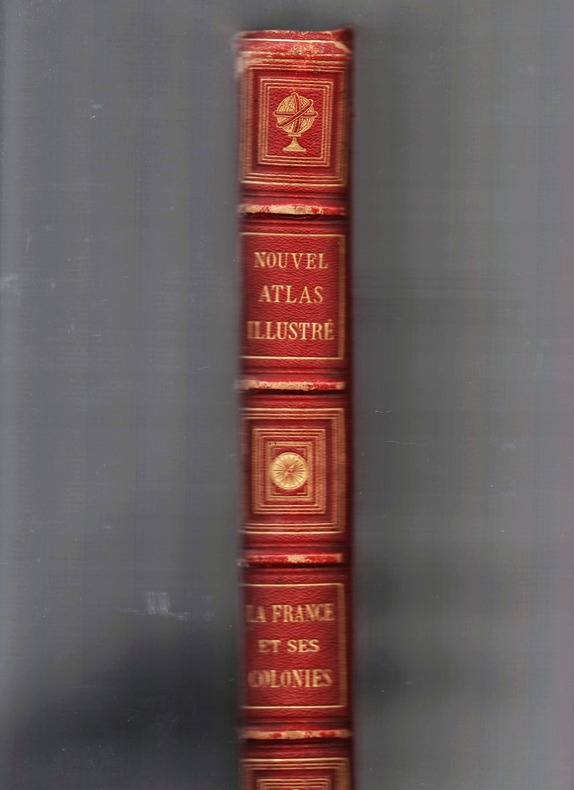
VUILLEMIN Alexandre / THUILIER L. / LACOSTE Ch. / MARTINEAU A. / STEIN H.
Nouvel atlas illustré la France et ses colonies.
Paris, Direction et Administration, 1892, 1 volume, in-folio, relié, non paginé, 2 feuillets d'introduction, 108 feuillets, 108 planches. 108 cartes en couleurs dont 5 doubles, montées sur onglets, de Fillatreau, gravées par Lecocq, Lebel, Bizet, Fontaine, Waltner, F. Delannoy et Barbier. Reliure d'époque, demi chagrin rouge, dos à nerfs avec caissons et fleurons spéciaux dorés, titre doré, plats de toile rouge avec encadrement et titre dorés sur le premier plat, petit accroc à la coiffe inférieure, frottements sur les nerfs, usure aux coins, petits défauts divers à la reliure.
書籍販売業者の参照番号
: 7404
|
|
|
vv. aa.
Congrès International de Geographie Amsterdam 1938
Union Geographique internationale; Tome II, travaux de la section I, Cartographie. In francese, tedesco e italiano. Articoli di Bertarelli e Lugli, Toraldo e molti altri internazionali. In ottimo stato, con molte carte e foto. Brossura
|
|
|
VV.AA.
ATLAS 2000 LA NUEVA VISION DE LA TIERRA.
245 mapas.
|
|
|
VV.AA.
ATLAS BASICO PARQUE REGIONAL DEL SURESTE. PARQUE EN TORNO A LOS EJES DE LOS CURSOS BAJOS DE LOS RIOS MANZANARES Y JARAMA.
Mapas y fotografias en color.
|
|
|
VV.AA.
GRAN ATLAS GEOGRAFICO UNIVERSAL DE ESPAÑA Y LA UNION EUROPEA.
Profusamente con mapas y fotografias a color.
|
|
|
VV.AA.
GRAN ATLAS SALVAT UNIVERSAL. TOMO I: PLANISFERIOS, EUROPA. TOMO II: ASIA, AFRICA. TOMO III: AMERICA DEL NORTE, AMERICA DEL SUR. TOMO IV: AMERICA DEL SUR, OCEANIA, INDICE.
Profusamente ilustrado.
|
|
|
W.G.J. Van Der Sluys
HET LAND VAN DE BIJBEL. Oudekaarten en prenten van Israel.
Ril. in tela con sovr., cm 38,5x30,5, pp 143, Moltissime splendide tavv. e ill. a col.. - ISBN: 9027405562

|
|
|
W[ILHELM?] DÖRFLEIN.
[UNPUBLISHED PHOTOGRAPHS with SOME AUTOGRAPH NOTES from a TRAVEL into TURKEY and GREECE] [Collection of nine photographs of a German traveller into Turkey, Greece and Middle East]: Reisebilder aus den Türkei.
Very Good German 9 original silver photographs; 6 with original cardboards, 3 on paper with their descriptive texts. Cardboards: 26x18 cm, photos: 13x9 cm. Title on cardboard and descriptions are in German. Cannot find any information about W. Dörflein. Photographs: Photo on titled cardboard (written "Reisebilder aus den Türkei" is a view from Aegean shores through the trees.; A view from Milet ruined city, can be seen mosque, village.; "Abstieg nach Tomatje" (i.e. Descent to tomatoes), can be seen a garden of tomatoes and butler of German traveler with his pony.; Ioran, Apollotempel von limps vorne (i.e. Ioran, Apollo temple of limps in front): Can be seen Apollon Temple.; Villa gegenüber der Insel Samos (Villa opposite the island of Samos).; Apollotempel zu Ioran (Apollon Temple in Ioran).; Last three photos glued on paper have descriptive autograph texts in German by Dörflein: "Kruppsches Feldgeschütz auf Pischan V. Abschnitt. Im Hintergründe das schneebedeckte Olitschka-Gebirge.; Drisko-Berg - Betonwerk Pischan - Das Zeltlager umfalste Im Festungsstab - Nazarett - V. Abschmitt: Pischan (Bisani oder Bezani).; Die schneebedeckten Berge stellen die griechische Grenze östl. des Arta-Flusses dar.; Beton werk der 15 cm. Haubitzen. Offiziers wohnung.; Mein Bursche Mustafa mit meinem Maulesel.". Small but a unique collection.
|
|
|
WAGNER Hermann
Die Rekonstruktion der Toscanelli-Karte v. J. 1474 und die Pseudo-Facsimilia des Behaim-Globus v. J. 1492
Göttingen, 1894 108pp. + 1 folding map, 24cm., text in German, in the series "Vorstudien zur Geschichte der Kartographie" volume III, offprint from "Nachrichten der K. Gesellschaft der Wissenschaften zu Göttingen, Philo.-historische Klasse" 1894 nr.3, modern blind wrappers (original frontcover preserved), text in good condition, rare, A97532
書籍販売業者の参照番号
: A97532
|
|
|
Wagenbreth, Otfried
Geologisches Kartenlesen und Profilzeichnen
23 cm, ril. edit. in tela, titolo al dorso e piatto, sovracoperta illustrata, p. 188, 189 immagini e fotografie, 3 tavolea colori. Tracce d'uso alla sovracoperta - Umschlag mit Gebrauchsspuren - Dustjacket with signs of wear

|
|
|
Waghenaer, Lucas Janszoon
Spieghel der Zeevaerdt.
[Amsterdam], [N. Israel], 1964. Folio. 41 cm. Nicht durchgehend paginiert. [4] Blatt, 36 Seiten. XXX gefaltete Karten mit Beschreibung, [4] Blatt. Original-Leinenband mit Original-Pappschuber.
書籍販売業者の参照番号
: 51655BB

|
|
|
Waghenauer
Spieghel der Zeevae van de navigatie der Westersche Zee. Printed bin Leyden by Christoffel Plantijn,Anno MDLXXXIV.
Ril. in tela con. cust., cm 4o,5 x 29,5, moltissime splendide carte a col.. Cet ouvrage, qui fait partie d'une collection de fac-simoleset dont l'original se trouve a la Bibliothequede l'Université d'Utrecht, est une pubblicationde Sequoia S.A.. Lausanne. Il a été achevé d'imprimer le premier juillet MCMLXIV.

|
|
|
Wagner Henry R.
The Cartography of the Northwest Coast of America to the Year 1800 2 vols. in 1 complete; new in publisher's shrinkwrap
Mansfield Centre Connecticut: Martino Publishing 1999. 2 volumes bound as 1 complete. BRAND NEW HARDCOVER in perfect condition. STILL SEALED in the publisher's clear plastic SHRINKWRAP. NO rubbing. NO fading. Bright clean square and tight. Sharp corners. NOT a library discard. NO owner's name or bookplate. NO remainder mark. Fresh and crisp -- obviously never read. No date but 1999 First Martino printing "Limited Edition Facsimile". Reprint of the 1937 two volume set. 2 vols. in 1: xii pp. 1-270; iv pp. 271-543 13 maps not included in the pagination. Well illustrated with 41 map reproductions including 13 that fold-out. Bound in the original pale yellow cloth stamped in bright gold over a handsome dark green spine panel. "Although emphasis is on the Northwest Coast of America this is a useful reference work for the student of the cartographic history of America. It contains an extensive index bibliography and list of place names as well as a list of maps." -- Ristow GUIDE TO THE HISTORY OF CARTOGRAPHY #377. Howes USIANA W7. Oversize Hardcover. 8.75" wide by 11" tall. This large heavy book will require extra postage for Priority and International shipments but only the standard charge for media mail. First Martino printing. Oversize Hardcover. New/in publisher's shrinkwrap. 2 vols. in 1: xii pp. 1-270; iv pp. 271-543. Great Packaging Fast Shipping. Martino Publishing Hardcover
書籍販売業者の参照番号
: 018413 ISBN : 1578981646 9781578981649
|
|
|
WAGNER Henry R. -
Cartography of the Nortwest Coast of America to the year 1800.
Amsterdam, Israel, 1968, due volumi in uno in-4to tutta tela editoriale con titoli dorati, pp. XI-543 con 40 carte ripiegate fuori testo. Reprint dell’edizione Berkeley, 18937.

|
|
|
WAGNER Hermann
Die Rekonstruktion der Toscanelli-Karte v. J. 1474 und die Pseudo-Facsimilia des Behaim-Globus v. J. 1492
108pp. + 1 folding map, 24cm., text in German, in the series "Vorstudien zur Geschichte der Kartographie" volume III, offprint from "Nachrichten der K. Gesellschaft der Wissenschaften zu Göttingen, Philo.-historische Klasse" 1894 nr.3, modern blind wrappers (original frontcover preserved), text in good condition, rare, A97532
|
|
|
Wagner, C
Die Bedeutung Bartholomä Herders für d. Kartographie.
Freiburg, Herder, (1939). M. Portr., Ktn. u. Abb. 15 S. OBr. Umschl. angeschmutzt.
書籍販売業者の参照番号
: 153988
|
|
|
Wajntraub E. & G.
Hebrew Maps of the Holy Land 1992 first edition new still in shrinkwrap
Wien: Br�der Hollinek 1992. Brand New in a Brand New dust jacket. Perfect condition. STILL SEALED in the publisher's clear plastic SHRINKWRAP. 1992. First Edition. NO chips. NO tears. NO creases. NO rubbing. NO fading. Bright shiny clean square and tight. Sharp corners. NOT a library discard. NO owner's name or bookplate. NO remainder mark. Fresh and crisp -- obviously never read. HEBREW MAPS OF THE HOLY LAND is beautifully illustrated with 136 maps 32 in full color. All text is in English. A knowledge of Hebrew is not necessary to read these maps as there are outline copies next to each one with place names/keys translated into English. Detailed commentary is provided for each map as well as useful notes on authors subsequent editions etc. The books where the maps were first published are identified. Also included here are little known biographical data on Hebrew map makers. Bound in the original blue cloth stamped in white. Complete with a pristine dust jacket. Oversize Hardcover. 9" wide by 11.25" tall. This large heavy book will require extra postage for Priority and International shipments but only the standard charge for media mail. First Edition. Oversize Hardcover. New/New DJ still in shrinkwrap. xxiv 277pp. Great Packaging Fast Shipping. Br�der Hollinek Hardcover
書籍販売業者の参照番号
: 018203 ISBN : 3851192486 9783851192483

|
|
|
Wajntraub, E. & G.
Hebrew Maps of the Holy Land
28.5x23 cm. XXIV+277 pages. Hardcover in dust jacket. As new. PLEASE NOTE: This item is overweight. We may ask for extra shipping costs.
|
|
|
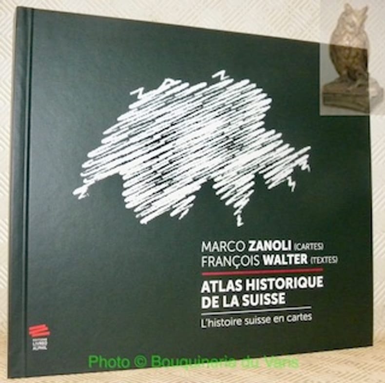
WALTER, François (textes). - ZANOLI, Marco (cartes).
Atlas historique de la Suisse. L'histoire suisse en cartes. 2e Edition.
Neuchâtel, Editions Livreo-Alphil 2021, 245x285mm, 195pages, reliure d'éditeur. Format oblong. Très bel exemplaire.
書籍販売業者の参照番号
: 106916
|
|
|
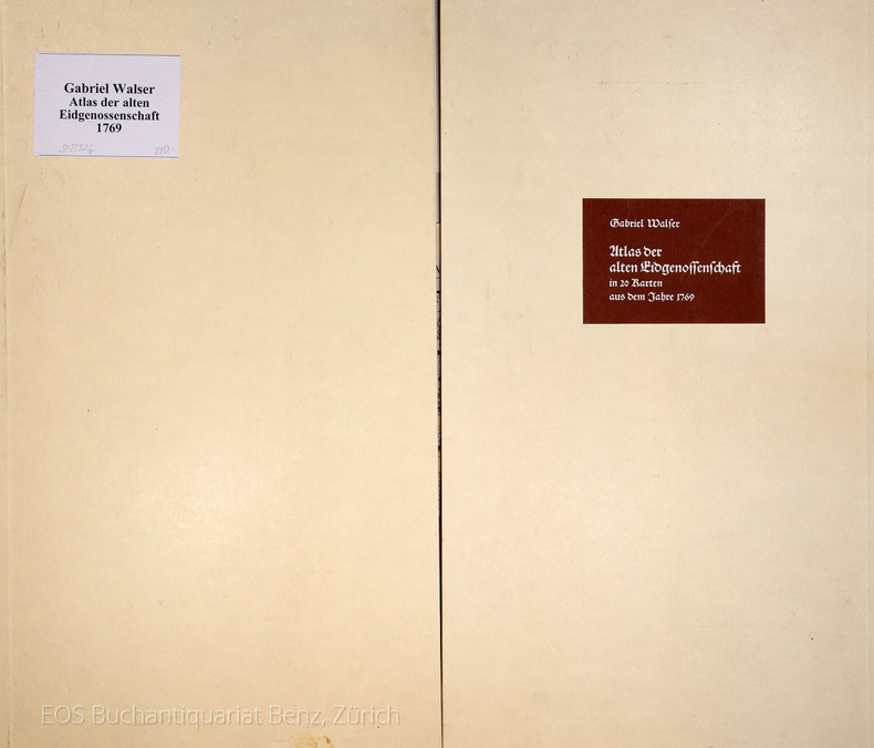
Walser, Gabriel:
Atlas der alten Eidgenossenschaft in 20 Karten aus dem Jahre 1769.
Gattikon, Verlag Dorfpresse, 1968. Folio. 2 Bl. Mit 20 kol. faks. Karten. Lose in Pappmappe.
書籍販売業者の参照番号
: 31223AB
|
|
|
WALTER MARDSEN
La laponie.
Collection les les grandes étendues sauvages ,éditions time life 1983 très bon état 184 pages in 4.
書籍販売業者の参照番号
: 3649
|
|
|
Walker J&C
HAMPSHIRE and The Isle of Wight Walkers Folding County Map
London: Longman Hurst Row Orme & Co. 1840. WALKERS COUNTY MAP SERIES. nd C1840. Folding map of Hampshire and The Isle of Wight laid on linen and dissected into 15 sections. Out-line hand-colour coloured woods and railway lines. Enclosed in a card case with a decorative paper label. Stain to the lower margin and affecting some folds otherwise an attractive travellers map in a v.g. condition. 41 x 34cms. 1st issue. Cloth. V.g. Longman, Hurst, Row, Orme & Co. Hardcover
書籍販売業者の参照番号
: Map871
|
|
|
Walker J&C
KENT Walkers Folding County Map
London: Longman Hurst Row Orme & Co. 1843. WALKERS COUNTY MAP SERIES. nd c1843. Folding map of KENTlaid on linen and dissected into 15 sections. Out-line hand-colour coloured woods and railway lines. Enclosed in a card case with a decorative paper label. Covers worn otherwise an attractive travellers map in a very clean condition. 34 x41 cms.13 x 16 inches. 1st issue. Cloth. V.g. Longman, Hurst, Row, Orme & Co. Hardcover
書籍販売業者の参照番号
: Map872
|
|
|
Walle, Paul
[French] De L'uruguay au Rio Sao Francisco
[French] Contain pictures. Contain a map. 14X22.5 XVIII+444 pages. Hardcover. Pages slightly yellowing. Else in good condition. PLEASE NOTE: This item is overweight. We may ask for extra shipping costs.
|
|
|
Wallenberg Jacob
Mio figlio sulla galea 1769-1770
6 illustrazioni nel testo 20 illustrazioni fuori testo a colori e in bianco e nero

|
|
|
Wallis Hellen M. - Robinson Arthur H
Cartographical Innovations. An International Handbook of Mapping Terms to 1900.
Ril. in tela con sovr., cm 24.5x18, pp 353, alcune tavv. in b/n.. - ISBN: 0906430046

|
|
|
Walser, Gabriel
Atlas der alten Eidgenossenschaft in 20 Karten aus dem Jahre 1769.
Gattikon, Verlag Dorfpresse, 1968. Folio. 2 Bl. Mit 20 kol. faks. Karten. Lose in Pappmappe. + Wichtig: Für unsere Kunden in der EU erfolgt der Versand alle 14 Tage verzollt ab Deutschland / Postbank-Konto in Deutschland vorhanden +, A|B
書籍販売業者の参照番号
: 31223AB

|
|
|
WARDINGTON LIBRARY.
The Wardington Library: Important Atlases & Geographies. Part One: A-K [-Part Two: L-Z].
2 Vols., 4to, 347;368pp., numerous plates and illustrations throughout (many coloured), orig. decorated cloth. "The collection of printed atlases and associated books assembled by the late Lord Wardington. is, in my view, the finest collection in private hands. In Sotheby's two-part sale over 650 individual items have been catalogued spanning the years from 1472 to the late twentieth century. There are some interesting incunabula containing maps, an example of the first atlas to be printed - the 1477 Bologna atlas by Claudius Ptolemaeus - with some maps as proof sheets, and a further two dozen Ptolemaic atlases up to the early eighteenth century. There follows a very wide range of atlases - Dutch, French, German, English, and others, including a strong array of holdings from the twentieth century; indeed with fresh acquisitions up to a year or so ago. It is unlikely that an offering such as this to the open market will be repeated!"?Introduction.
|
|
|
Waser, Mauro
Geografia illustrata della Svizzera per la scuola e per la casa. Prima edizione italiana sulla sesta tedesca
16°, 19 cm, pp. 286, (8), tavola a colori con gli stemmi dei cantoni all'antiporta, numerose incisioni e alcune fotografie nel testo, a cura di Eligio Pometta. Rilegatura editoriale in mezza tela, titolo incorniciato al piatto. rare sottolineature a matita, qualche brunitura, timbro di libreria al frontespizio, esemplare nell'assieme molto buono
|
|
|
Wassermann Farmaco Terapeuticas. Cartografia: Bescos Dolcet
Sociedad Espanola de Especialidades Wassermann Farmaco Terapeuticas / Atlas Turistico de Espana
no city Spain: Wassermann 1940. Nineteen quarto leaves of alkaline paperstock each folded vertically in half to make nineteen separate advertising brochures of 8.5x5.5 inches all four faces of each brochure printed in colors with a come-on cover; pages within pp.2 & 3 print a detailed doublespread color map back cover mostly text with spot-color touches. Partial set 19 of an original total of 42. Each map features a different region or province in Spain including the Islands and North Africa while exterior covers boast a different medicine medications for the blood or bone for young and old: Take Aspasmol a sedative for spaamodic attacks &c &c. Please note that nos.13 and 37 use the same cover image but deal different meds and differing parts of Spain. All in nice condition clean and sound. Wassermann unknown books
書籍販売業者の参照番号
: 250450
|
|
|
WATELET Marcel
"Cartographie et politique dans la Belgique du XIXe siècle; matériaux pour l'histoire nationale et locale. Aux origines du Ministère des Travaux Publics."
Bruxelles, Crédit Communal de Belgique, 1987. 25 x 34, 273 pp., très nombreuses cartes en couleurs, quelques illustrations en couleurs et en N/B, reliure d'édition pleine toile, très bon état (1 cachet d'ex-propriétaire).
書籍販売業者の参照番号
: 91030
|
|
|
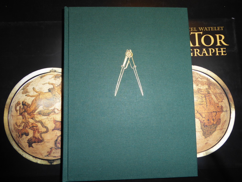
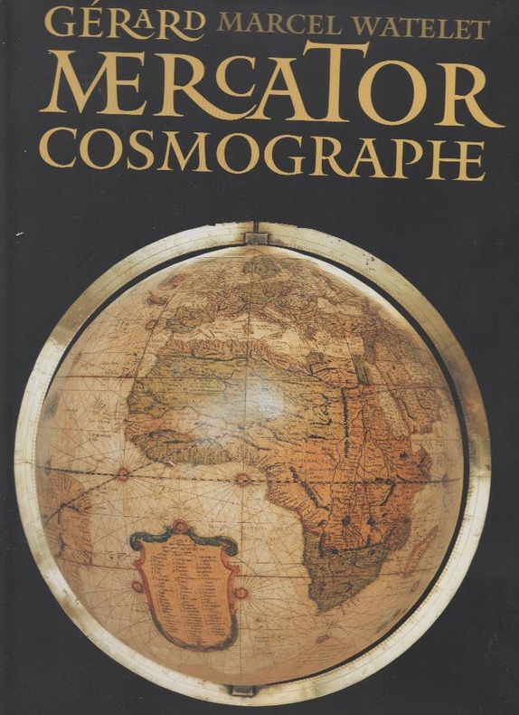
WATELET Marcel, et autres
"Gérard Mercator, cosmographe; le temps et l'espace. "
Belgique, Fonds Mercator Paribas, 1994 25 x 33, 445 pp., très nombreuses illustrations en couleurs pour la plupart, reliure d'édition pleine toile + jaquette rempliée, sous étui carton noir illustré, très bon état.
書籍販売業者の参照番号
: 79561
|
|
|
WATELET, Marcel.
CARTOGRAFIE EN POLITIEK IN HET BELGIE VAN DE 19de EEUW.
Brussel, Gemeentekrediet, 1987 Gebonden, beige linnen hardcover met bruine opdruk, originele uitgeversomslag met flappen in kleur, 34.2x24.8 cm., 271 pp. + 5, geillustreerd in kleur en in z/w. ISBN 9050660304.
書籍販売業者の参照番号
: 2969
|
|
|
Watelet Marcel. {direction}.
GERARD MERCATOR COSMOGRAPHE, le temps et l'espace.
, Antwerpen, Mercatorfonds, 1994., grand In-4 toile, sous etui, illustrates et sous jaquette, 445pp. BON ETAT ! ISBN 9061533147.
書籍販売業者の参照番号
: 2576
|
|
|
WATELET, MARCEL.
GERARDI MERCATORIS ATLAS EUROPAE.
, Antwerpen, Bibliotheek van de Vrienden van het Mercatorfonds, 1994., Suite, niet gebonden, met foudraal, vergulde bandstempel op de voorplaat, rug versierd met vergulde titel, zonder omslagwikkel, 27,5x40cm, 92pp + 17 uitvouwbare kaarten in kleur. ISBN 9789061533177.
書籍販売業者の参照番号
: 12046
|
|
|
WATELET (Marcel) et autres :
Gérard Mercator cosmographe. Le temps et l’espace.
[Anvers], Fonds Mercator et la Banque BNP Paribas Belgique, 1994. Grand in-4, 445[dont faux-titre et titre]-(1) pp. – (1) f.[Colophon/registre- ancien- de caractères], bradel toile verte, titre doré au dos, compas doré sur le plat supérieur, jaquette rempliée et étui illustrés en couleurs (reliure de l’Éditeur ; infimes défauts sur l’étui, sinon exemplaire quasi-parfait).
書籍販売業者の参照番号
: 80197
|
|
|
WATELET Marcel ..//.. Sous la direction de Marcel Watelet.
Gérard Mercator cosmographe, le temps et l'espace.
sl (Bruxelles), Fonds Mercator Paribas, 1994, 1 volume, in-4, relié, 445 p.. Ouvrage tiré à 10 000 exemplaires. Très nombreuses illustrations en couleur, certaines à pleine page, 2 planches dépliantes (planches quadruples), catalogus, chronologie, notes, bibliographie, index des noms et index topographique en fin de volume. Reliure éditeur, pleine toile verte sous jaquette illustrée en couleur, emboîtage rigide assorti.
書籍販売業者の参照番号
: 4912
|
|
 検索結果のメールを受信する
 PDFファイルの検索結果をダウンロード
 RSSフィード


