|
WAGNER Hermann
Die Rekonstruktion der Toscanelli-Karte v. J. 1474 und die Pseudo-Facsimilia des Behaim-Globus v. J. 1492
Göttingen, 1894 108pp. + 1 folding map, 24cm., text in German, in the series "Vorstudien zur Geschichte der Kartographie" volume III, offprint from "Nachrichten der K. Gesellschaft der Wissenschaften zu Göttingen, Philo.-historische Klasse" 1894 nr.3, modern blind wrappers (original frontcover preserved), text in good condition, rare, A97532
书商的参考编号 : A97532
|
|
|
Wagenbreth, Otfried
Geologisches Kartenlesen und Profilzeichnen
23 cm, ril. edit. in tela, titolo al dorso e piatto, sovracoperta illustrata, p. 188, 189 immagini e fotografie, 3 tavolea colori. Tracce d'uso alla sovracoperta - Umschlag mit Gebrauchsspuren - Dustjacket with signs of wear

|
|
|
Waghenaer, Lucas Janszoon
Spieghel der Zeevaerdt.
[Amsterdam], [N. Israel], 1964. Folio. 41 cm. Nicht durchgehend paginiert. [4] Blatt, 36 Seiten. XXX gefaltete Karten mit Beschreibung, [4] Blatt. Original-Leinenband mit Original-Pappschuber.
书商的参考编号 : 51655BB

|
|
|
Waghenauer
Spieghel der Zeevae van de navigatie der Westersche Zee. Printed bin Leyden by Christoffel Plantijn,Anno MDLXXXIV.
Ril. in tela con. cust., cm 4o,5 x 29,5, moltissime splendide carte a col.. Cet ouvrage, qui fait partie d'une collection de fac-simoleset dont l'original se trouve a la Bibliothequede l'Université d'Utrecht, est une pubblicationde Sequoia S.A.. Lausanne. Il a été achevé d'imprimer le premier juillet MCMLXIV.

|
|
|
Wagner Henry R.
The Cartography of the Northwest Coast of America to the Year 1800 2 vols. in 1 complete; new in publisher's shrinkwrap
Mansfield Centre Connecticut: Martino Publishing 1999. 2 volumes bound as 1 complete. BRAND NEW HARDCOVER in perfect condition. STILL SEALED in the publisher's clear plastic SHRINKWRAP. NO rubbing. NO fading. Bright clean square and tight. Sharp corners. NOT a library discard. NO owner's name or bookplate. NO remainder mark. Fresh and crisp -- obviously never read. No date but 1999 First Martino printing "Limited Edition Facsimile". Reprint of the 1937 two volume set. 2 vols. in 1: xii pp. 1-270; iv pp. 271-543 13 maps not included in the pagination. Well illustrated with 41 map reproductions including 13 that fold-out. Bound in the original pale yellow cloth stamped in bright gold over a handsome dark green spine panel. "Although emphasis is on the Northwest Coast of America this is a useful reference work for the student of the cartographic history of America. It contains an extensive index bibliography and list of place names as well as a list of maps." -- Ristow GUIDE TO THE HISTORY OF CARTOGRAPHY #377. Howes USIANA W7. Oversize Hardcover. 8.75" wide by 11" tall. This large heavy book will require extra postage for Priority and International shipments but only the standard charge for media mail. First Martino printing. Oversize Hardcover. New/in publisher's shrinkwrap. 2 vols. in 1: xii pp. 1-270; iv pp. 271-543. Great Packaging Fast Shipping. Martino Publishing Hardcover
书商的参考编号 : 018413 ???????? : 1578981646 9781578981649
|
|
|
WAGNER Henry R. -
Cartography of the Nortwest Coast of America to the year 1800.
Amsterdam, Israel, 1968, due volumi in uno in-4to tutta tela editoriale con titoli dorati, pp. XI-543 con 40 carte ripiegate fuori testo. Reprint dell’edizione Berkeley, 18937.

|
|
|
WAGNER Hermann
Die Rekonstruktion der Toscanelli-Karte v. J. 1474 und die Pseudo-Facsimilia des Behaim-Globus v. J. 1492
108pp. + 1 folding map, 24cm., text in German, in the series "Vorstudien zur Geschichte der Kartographie" volume III, offprint from "Nachrichten der K. Gesellschaft der Wissenschaften zu Göttingen, Philo.-historische Klasse" 1894 nr.3, modern blind wrappers (original frontcover preserved), text in good condition, rare, A97532
|
|
|
Wagner, C
Die Bedeutung Bartholomä Herders für d. Kartographie.
Freiburg, Herder, (1939). M. Portr., Ktn. u. Abb. 15 S. OBr. Umschl. angeschmutzt.
书商的参考编号 : 153988
|
|
|
Wajntraub E. & G.
Hebrew Maps of the Holy Land 1992 first edition new still in shrinkwrap
Wien: Br�der Hollinek 1992. Brand New in a Brand New dust jacket. Perfect condition. STILL SEALED in the publisher's clear plastic SHRINKWRAP. 1992. First Edition. NO chips. NO tears. NO creases. NO rubbing. NO fading. Bright shiny clean square and tight. Sharp corners. NOT a library discard. NO owner's name or bookplate. NO remainder mark. Fresh and crisp -- obviously never read. HEBREW MAPS OF THE HOLY LAND is beautifully illustrated with 136 maps 32 in full color. All text is in English. A knowledge of Hebrew is not necessary to read these maps as there are outline copies next to each one with place names/keys translated into English. Detailed commentary is provided for each map as well as useful notes on authors subsequent editions etc. The books where the maps were first published are identified. Also included here are little known biographical data on Hebrew map makers. Bound in the original blue cloth stamped in white. Complete with a pristine dust jacket. Oversize Hardcover. 9" wide by 11.25" tall. This large heavy book will require extra postage for Priority and International shipments but only the standard charge for media mail. First Edition. Oversize Hardcover. New/New DJ still in shrinkwrap. xxiv 277pp. Great Packaging Fast Shipping. Br�der Hollinek Hardcover
书商的参考编号 : 018203 ???????? : 3851192486 9783851192483

|
|
|
Wajntraub, E. & G.
Hebrew Maps of the Holy Land
28.5x23 cm. XXIV+277 pages. Hardcover in dust jacket. As new. PLEASE NOTE: This item is overweight. We may ask for extra shipping costs.
|
|
|
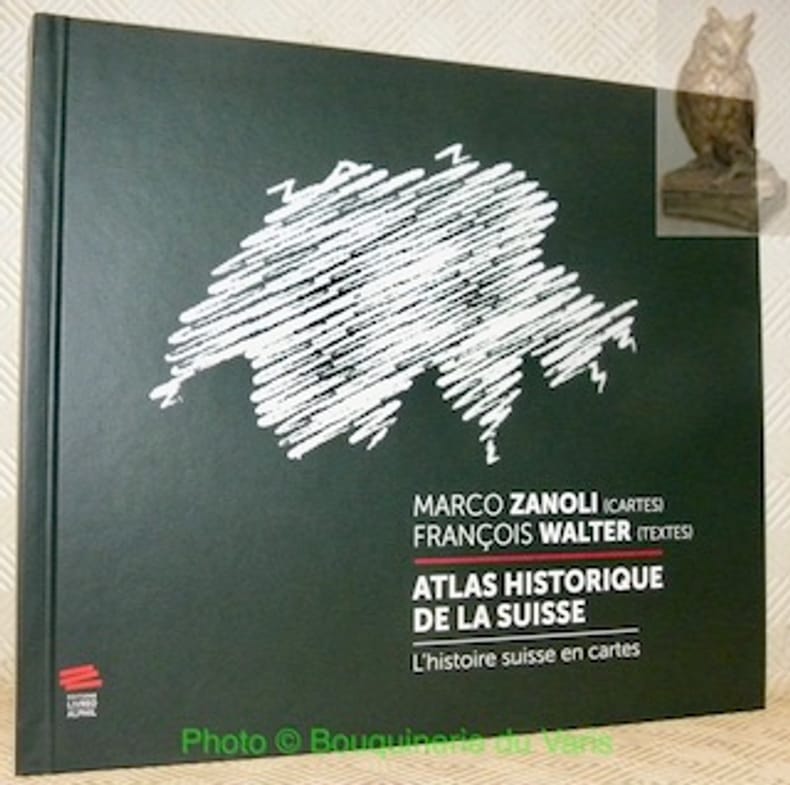
WALTER, François (textes). - ZANOLI, Marco (cartes).
Atlas historique de la Suisse. L'histoire suisse en cartes. 2e Edition.
Neuchâtel, Editions Livreo-Alphil 2021, 245x285mm, 195pages, reliure d'éditeur. Format oblong. Très bel exemplaire.
书商的参考编号 : 106916
|
|
|
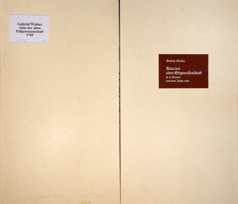
Walser, Gabriel:
Atlas der alten Eidgenossenschaft in 20 Karten aus dem Jahre 1769.
Gattikon, Verlag Dorfpresse, 1968. Folio. 2 Bl. Mit 20 kol. faks. Karten. Lose in Pappmappe.
书商的参考编号 : 31223AB
|
|
|
WALTER MARDSEN
La laponie.
Collection les les grandes étendues sauvages ,éditions time life 1983 très bon état 184 pages in 4.
书商的参考编号 : 3649
|
|
|
Walker J&C
HAMPSHIRE and The Isle of Wight Walkers Folding County Map
London: Longman Hurst Row Orme & Co. 1840. WALKERS COUNTY MAP SERIES. nd C1840. Folding map of Hampshire and The Isle of Wight laid on linen and dissected into 15 sections. Out-line hand-colour coloured woods and railway lines. Enclosed in a card case with a decorative paper label. Stain to the lower margin and affecting some folds otherwise an attractive travellers map in a v.g. condition. 41 x 34cms. 1st issue. Cloth. V.g. Longman, Hurst, Row, Orme & Co. Hardcover
书商的参考编号 : Map871
|
|
|
Walker J&C
KENT Walkers Folding County Map
London: Longman Hurst Row Orme & Co. 1843. WALKERS COUNTY MAP SERIES. nd c1843. Folding map of KENTlaid on linen and dissected into 15 sections. Out-line hand-colour coloured woods and railway lines. Enclosed in a card case with a decorative paper label. Covers worn otherwise an attractive travellers map in a very clean condition. 34 x41 cms.13 x 16 inches. 1st issue. Cloth. V.g. Longman, Hurst, Row, Orme & Co. Hardcover
书商的参考编号 : Map872
|
|
|
Walle, Paul
[French] De L'uruguay au Rio Sao Francisco
[French] Contain pictures. Contain a map. 14X22.5 XVIII+444 pages. Hardcover. Pages slightly yellowing. Else in good condition. PLEASE NOTE: This item is overweight. We may ask for extra shipping costs.
|
|
|
Wallenberg Jacob
Mio figlio sulla galea 1769-1770
6 illustrazioni nel testo 20 illustrazioni fuori testo a colori e in bianco e nero

|
|
|
Wallis Hellen M. - Robinson Arthur H
Cartographical Innovations. An International Handbook of Mapping Terms to 1900.
Ril. in tela con sovr., cm 24.5x18, pp 353, alcune tavv. in b/n.. - ISBN: 0906430046

|
|
|
Walser, Gabriel
Atlas der alten Eidgenossenschaft in 20 Karten aus dem Jahre 1769.
Gattikon, Verlag Dorfpresse, 1968. Folio. 2 Bl. Mit 20 kol. faks. Karten. Lose in Pappmappe. + Wichtig: Für unsere Kunden in der EU erfolgt der Versand alle 14 Tage verzollt ab Deutschland / Postbank-Konto in Deutschland vorhanden +, A|B
书商的参考编号 : 31223AB

|
|
|
WARDINGTON LIBRARY.
The Wardington Library: Important Atlases & Geographies. Part One: A-K [-Part Two: L-Z].
2 Vols., 4to, 347;368pp., numerous plates and illustrations throughout (many coloured), orig. decorated cloth. "The collection of printed atlases and associated books assembled by the late Lord Wardington. is, in my view, the finest collection in private hands. In Sotheby's two-part sale over 650 individual items have been catalogued spanning the years from 1472 to the late twentieth century. There are some interesting incunabula containing maps, an example of the first atlas to be printed - the 1477 Bologna atlas by Claudius Ptolemaeus - with some maps as proof sheets, and a further two dozen Ptolemaic atlases up to the early eighteenth century. There follows a very wide range of atlases - Dutch, French, German, English, and others, including a strong array of holdings from the twentieth century; indeed with fresh acquisitions up to a year or so ago. It is unlikely that an offering such as this to the open market will be repeated!"?Introduction.
|
|
|
Waser, Mauro
Geografia illustrata della Svizzera per la scuola e per la casa. Prima edizione italiana sulla sesta tedesca
16°, 19 cm, pp. 286, (8), tavola a colori con gli stemmi dei cantoni all'antiporta, numerose incisioni e alcune fotografie nel testo, a cura di Eligio Pometta. Rilegatura editoriale in mezza tela, titolo incorniciato al piatto. rare sottolineature a matita, qualche brunitura, timbro di libreria al frontespizio, esemplare nell'assieme molto buono
|
|
|
Wassermann Farmaco Terapeuticas. Cartografia: Bescos Dolcet
Sociedad Espanola de Especialidades Wassermann Farmaco Terapeuticas / Atlas Turistico de Espana
no city Spain: Wassermann 1940. Nineteen quarto leaves of alkaline paperstock each folded vertically in half to make nineteen separate advertising brochures of 8.5x5.5 inches all four faces of each brochure printed in colors with a come-on cover; pages within pp.2 & 3 print a detailed doublespread color map back cover mostly text with spot-color touches. Partial set 19 of an original total of 42. Each map features a different region or province in Spain including the Islands and North Africa while exterior covers boast a different medicine medications for the blood or bone for young and old: Take Aspasmol a sedative for spaamodic attacks &c &c. Please note that nos.13 and 37 use the same cover image but deal different meds and differing parts of Spain. All in nice condition clean and sound. Wassermann unknown books
书商的参考编号 : 250450
|
|
|
WATELET Marcel
"Cartographie et politique dans la Belgique du XIXe siècle; matériaux pour l'histoire nationale et locale. Aux origines du Ministère des Travaux Publics."
Bruxelles, Crédit Communal de Belgique, 1987. 25 x 34, 273 pp., très nombreuses cartes en couleurs, quelques illustrations en couleurs et en N/B, reliure d'édition pleine toile, très bon état (1 cachet d'ex-propriétaire).
书商的参考编号 : 91030
|
|
|
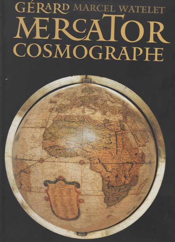
WATELET Marcel, et autres
"Gérard Mercator, cosmographe; le temps et l'espace. "
Belgique, Fonds Mercator Paribas, 1994 25 x 33, 445 pp., très nombreuses illustrations en couleurs pour la plupart, reliure d'édition pleine toile + jaquette rempliée, sous étui carton noir illustré, très bon état.
书商的参考编号 : 79561
|
|
|
WATELET, Marcel.
CARTOGRAFIE EN POLITIEK IN HET BELGIE VAN DE 19de EEUW.
Brussel, Gemeentekrediet, 1987 Gebonden, beige linnen hardcover met bruine opdruk, originele uitgeversomslag met flappen in kleur, 34.2x24.8 cm., 271 pp. + 5, geillustreerd in kleur en in z/w. ISBN 9050660304.
书商的参考编号 : 2969
|
|
|
WATELET Marcel
Chemins impériaux & voies royales. Essai sur la cartographie et l'ingénierie routières en Wallonie au début du XIXe siècle.
Bruxelles/Namur MET/Racine 1998 Hardcover, in-4 , 33x25cm, toile d'éditeur avec jq. ill., 264 pp., illustrations (surtout des cartes et plans) en couleurs & NB. Indexes, bibliographie, sources d'archives (Bruxelles, paris, La Haye, Vincennes). "Monumenta Cartographica Walloniae 3". L'Ouvrage couvre 3 periodes: les régimes français (1795-1814) avec une détérorisation, le temps de l'acmé ou le point culminant 1814-1815, le gouvernement Orangiste (1814-1830). "Si, dans nos régions, le régime français a peu construit de routes nouvelles en 15 ans de gestion, le régime hollandais, fort des projèts du Consulat et de l'Empire, en a réalisé quatre fois plus." (p. 252) Ouvrage lucide et important!
书商的参考编号 : 19980066
|
|
|
Watelet Marcel. {direction}.
GERARD MERCATOR COSMOGRAPHE, le temps et l'espace.
, Antwerpen, Mercatorfonds, 1994., grand In-4 toile, sous etui, illustrates et sous jaquette, 445pp. BON ETAT ! ISBN 9061533147.
书商的参考编号 : 2576
|
|
|
WATELET, MARCEL.
GERARDI MERCATORIS ATLAS EUROPAE.
, Antwerpen, Bibliotheek van de Vrienden van het Mercatorfonds, 1994., Suite, niet gebonden, met foudraal, vergulde bandstempel op de voorplaat, rug versierd met vergulde titel, zonder omslagwikkel, 27,5x40cm, 92pp + 17 uitvouwbare kaarten in kleur. ISBN 9789061533177.
书商的参考编号 : 12046
|
|
|
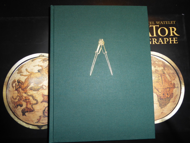
WATELET (Marcel) et autres :
Gérard Mercator cosmographe. Le temps et l’espace.
[Anvers], Fonds Mercator et la Banque BNP Paribas Belgique, 1994. Grand in-4, 445[dont faux-titre et titre]-(1) pp. – (1) f.[Colophon/registre- ancien- de caractères], bradel toile verte, titre doré au dos, compas doré sur le plat supérieur, jaquette rempliée et étui illustrés en couleurs (reliure de l’Éditeur ; infimes défauts sur l’étui, sinon exemplaire quasi-parfait).
书商的参考编号 : 80197
|
|
|
WATELET Marcel ..//.. Sous la direction de Marcel Watelet.
Gérard Mercator cosmographe, le temps et l'espace.
sl (Bruxelles), Fonds Mercator Paribas, 1994, 1 volume, in-4, relié, 445 p.. Ouvrage tiré à 10 000 exemplaires. Très nombreuses illustrations en couleur, certaines à pleine page, 2 planches dépliantes (planches quadruples), catalogus, chronologie, notes, bibliographie, index des noms et index topographique en fin de volume. Reliure éditeur, pleine toile verte sous jaquette illustrée en couleur, emboîtage rigide assorti.
书商的参考编号 : 4912
|
|
|
WATTELET (Marcel)
Gérard Mercator cosmographe. Le temps et l’espace
Anvers, Fond Mercator, Paribas 1994 Grand in-4 25 x 34 cm. Reliure de l’éditeur pleine toile verte sous jaquette rempliée illustrée en couleurs et étui, 445 pp. Très nombreuses illustrations en noir et en couleurs dans le texte et à pleine page. Exemplaire en excellent état. Très bel ouvrage publié à l’occasion du 400e anniversaire de la mort de Gérard Mercator 1512-1594 humaniste, mathématicien, géographe des Pays-Bas espagnols, inventeur de la projection qui porte son nom.
书商的参考编号 : 57473
|
|
|
WATELET, M.
MERCATOR, GERARDUS MERCATOR RUPELMUNDANUS.
Antwerpen, Mercatorfonds, 1994 linnen band met goudstempeling, geplastificeerde stofomslag, 340 x 260 mm., 448 pp., 450 illustraties waarvan 350 in kleur. Cassette. ISBN 9061533139.
书商的参考编号 : 533
|
|
|
WATELET Marcel
Patrimoine cartographique de Wallonie. Le terrain des ingénieurs. La cartographie routière en Wallonie au XVIIIe siècle.
Namur/Bruxelles MET/Racine 1995 Hardcover, in-4 , 33x25cm, toile d'éditeur avec jq. ill., 231 pp., illustrations (surtout des cartes et plans) en couleurs & NB, index, bibliographie. "Monumenta Cartographica Walloniae 2".
书商的参考编号 : 19950065
|
|
|
WATELET, Marcel.
CARTOGRAFIE EN POLITIEK IN HET BELGIE VAN DE 19de EEUW.
Gebonden, beige linnen hardcover met bruine opdruk, originele uitgeversomslag met flappen in kleur, 34.2x24.8 cm., 271 pp. + 5, geillustreerd in kleur en in z/w. ISBN 9050660304. De beginjaren van het ministerie van Openbare Werken. Bronnen voor de nationale en lokale geschiedschrijving.

|
|
|
WATELET, MARCEL.
GERARDI MERCATORIS ATLAS EUROPAE.
Suite, niet gebonden, met foudraal, vergulde bandstempel op de voorplaat, rug versierd met vergulde titel, zonder omslagwikkel, 27,5x40cm, 92pp + 17 uitvouwbare kaarten in kleur. ISBN 9789061533177. Een facsimili-uitgave van kaarten van Gerard Mercator uit de Atlas van Europa, ca. 1570 - 1572.

|
|
|
Wauwermans, Lieutenant-General
Histoire de L'Ecole Cartographique Belge et Anversoise du XVIe siecle. Amsterdam, Meridian Publishing Co, 1964. 2 vols.
Amst., 1964, ,
书商的参考编号 : 26107
|
|
|
Wauwermans, Lieutenant-General
Histoire de L'Ecole Cartographique Belge et Anversoise du XVIe siecle. Amsterdam, Meridian Publishing Co, 1964. 2 vols.
2 vols. 402,470 pp. 15 plts. Soft cover.*Reprint of the 1895 edition, fine condition.

|
|
|
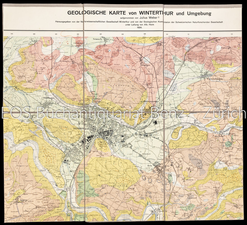
Weber, Julius:
Geologische Karte von Winterthur und Umgebung.
Winterthur, 1924. Farbige Karte auf Leinen aufgezogen. 59 x 87 cm.
书商的参考编号 : 1802AG
|
|
|
Weber, Julius
Geologische Karte von Winterthur und Umgebung.
Winterthur, 1924. Farbige Karte auf Leinen aufgezogen. 59 x 87 cm. + Wichtig: Für unsere Kunden in der EU erfolgt der Versand alle 14 Tage verzollt ab Deutschland / Postbank-Konto in Deutschland vorhanden +, A|B [2 Warenabbildungen]
书商的参考编号 : 1802AG

|
|
|
Weber,Hans
Sud Italia. Basilicata, Calabria, Campania, Puglia.
<br/> TITOLO: Sud Italia. Basilicata, Calabria, Campania, Puglia. <br/> AUTORE: Weber,Hans<br/> CURATORE: Testo di Heinz - Joachim Fischer. Traduz.di Ingeborg Babitsch.<br/> EDITORE: Cantini Ed.<br/> DATA ED.: 1989,<br/> EAN: 9788877370914
|
|
|
WEDEKIN BEATE, sous la direction D'ANGELIKA TASCHEN
Intérieurs New Yorkais.
1997 Taschen 1997, 299 pages, grand in 4 reliure cartonnée toilée bleue en très bon état avec jaquette en état d'usage (petite usures).
书商的参考编号 : 14410
|
|
|
Wegener Alfred
LA FORMAZIONE DEI CONTINENTI E DEGLI OCEANI.
(Codice OS/0037) In 8° 320 pp., 63 figurei. Prima edizione. Data e firma. Brossura editoriale, ottimo stato. ~~~ SPEDIZIONE IN ITALIA SEMPRE TRACCIATA

|
|
|
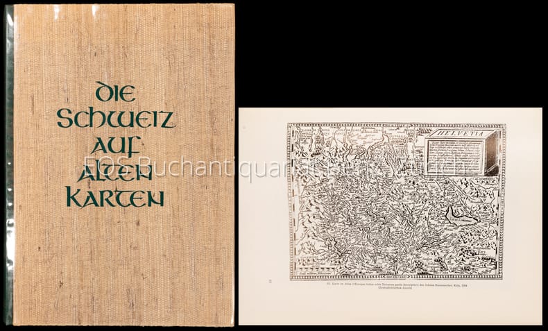
WEISZ, Leo:
Die Schweiz auf alten Karten. Mit Geleitwort und einem kartographisch - technischen Anhang von Ed. Imhof.
Zürich, Verlag der Neue Zürcher Zeitung, 1945, in-4to, 227 S. + 4 n.numm. S., mit Textabb. u. 244 z.T. gefalt. Kartenabb., Widmung vom Vorbesitzer auf Vorsatz, Original H.-Leinenband, (erste Ausgabe).
书商的参考编号 : 128731aaf
|
|
|
WEISZ, Leo:
Die Schweiz auf alten Karten. Mit Geleitwort und einem kartographisch - technischen Anhang von Ed. Imhof.
Zürich, Verlag der Neue Zürcher Zeitung, 1945, in-4to, 227 S. + 4 n.numm. S., mit Textabb. u. 244 z.T. gefalt. Kartenabb., Original H.-Leinenband, Orig. ill. Umschlag. (Erste Ausgabe).
书商的参考编号 : 130316aaf
|
|
|
Weisz, Leo:
Die Schweiz auf alten Karten. Mit Geleitwort und einem kartographisch-technischen Anhang von Prof. Ed. Imhof.
2. Auflage. Zürich, NZZ, 1969. 4°. 247 S. Mit zahlr. (dv. viele gef.) Karten u. Textillustr. nach alten Vorlagen. Orig.-Halblederband.
书商的参考编号 : 4008CB
|
|
|
WEISS (Helmut) DUNCKER (Dieter R.)
duche de Brabant en cartes et gravures anciennes.
, Duculot / Mappamundi,1983 Gembloux / Knokke, Belgique, 1983., Couverture reliee sous jaquette, 160 pages, 39 x31 cm, ** tres bon etat ( neuf !!! ). ISBN 9782801104767.
书商的参考编号 : 52071
|
|
|
WEISS (Helmut) DUNCKER (Dieter R.)
duche de Brabant en cartes et gravures anciennes.
Gembloux / Knokke, Duculot / Mappamundi,1983, 1983 Hardcover, 160 pages, Texte en Francais, 385 x 305 mm, Tres belle exemplaire !!. ISBN 9782801104767.
书商的参考编号 : 55288
|
|
|
Weigel Christoph
Vindelicia Rheti et Noricum
30,5 x 38,5 cm. Incisione in rame a pieni margini, con acquarellatura d'epoca. Piccolo cartiglio sulla sinistra, rappresentante un ritrovamento archeologico di una lapide con inciso il titolo della carta ed la firma dell'autore sorro. A fianco quattro monete romane. Qualche fioritura, piccole abrasioni alla piega naturale della carta.

|
|
|
WEIGEL Johann Christoph (1661 - 1726)
AUSTRIA inferior Secundum IIII. Quadrantes & regiones contiguas excudente Christophoro Weigelio
CARTA GEOGRAFICA di cm. 34,8x28,2 al filo della lastra, incisa in rame su forte carta pregiata di cm. 45,3x36,7 e colorata a amano all'epoca, proveniente da Atlante (probabilm. "Atlas Portatilis, Oder Compendieuse Vorstellung Der gantzen Welt: in einer kleinen Cosmographie, 1723) in cui era rilegata mediante brachetta alla piega. Uno dei primi atlanti scolastici, utile anche ai viaggiatori. WEIGEL, incisore su rame, mercante d'arte ed editore (cfr de.wikipedia).Perfettamente conservata.
|
|
|
WEIGEL Johann Christoph (1661 - 1726)
BELGIUM Regium accuratissime descriptum cum permutationibus cursus publici curante Christophoro Weigelio Noribergae
CARTA GEOGRAFICA di cm. 39x34,4 al filo della lastra, incisa in rame su forte carta pregiata di cm. 44x36,7 e COLORATA a mano all'epoca, proveniente da Atlante (probabilm. "Atlas Portatilis, Oder Compendieuse Vorstellung Der gantzen Welt: in einer kleinen Cosmographie, 1723) in cui era rilegata mediante brachetta alla piega. Uno dei primi atlanti scolastici, utile anche ai viaggiatori. WEIGEL, incisore su rame, mercante d'arte ed editore (cfr de.wikipedia). Salvo una fessura di 5 cm.al bordo inferiore della piega, è perfettamente conservata.
|
|
 ?????????
 ?????PDF???
 RSS feed


