|
|
|
KAISERLICH-KÖNIGLISCHES MILITAR-GEOGRAPHISCHES INSTITUT].
[MAP of OTTOMAN BALKANS] L.13. Durazzo. Vilajet Scutari - Mittel Albanien. [Scutari Province - Middle Albania].
Very Good German Original color map on cloth. Folded. A good copy. Oblong folio. (45 x 51 cm). In German. [MAP of OTTOMAN BALKANS] L.13. Durazzo. Vilajet Scutari - Mittel Albanien. [Scutari Province - Middle Albania]. Turkish toponyms in German. A sheet of the collection of 'The general map of Central Europe'. appeared in the years between 1873-1876 with the work of Joseph Ritter von Scheda, (1815-1888) who was a general, geographer and cartographer.
|
|
|
KAISERLICH-KÖNIGLISCHES MILITAR-GEOGRAPHISCHES INSTITUT].
[MAP of OTTOMAN BALKANS] L.14. Berat.
Very Good German Original color map on cloth. Oblong atlas folio. (46 x 52 cm). Toponyms in German. [MAP of OTTOMAN BALKANS] L.14. Berat. Shows South Albanian shores, Corfu, Berat et alli. Lithography. (Argyrokastro). A sheet of the collection of 'The general map of Central Europe'. appeared in the years between 1873-1876 with the work of Joseph Ritter von Scheda, (1815-1888) who was a general, geographer and cartographer.
|
|
|
KAISERLICH-KÖNIGLISCHES MILITAR-GEOGRAPHISCHES INSTITUT].
[MAP of OTTOMAN BALKANS] M.13. Monastir (Köprülü). Macedonia.
Very Good German Original color map on cloth. Folded. Oblong folio. (45 x 51 cm). In German. [MAP of OTTOMAN BALKANS] M.13. Monastir (Köprülü). Macedonia. A sheet of the collection of 'The general map of Central Europe'. appeared in the years between 1873-1876 with the work of Joseph Ritter von Scheda, (1815-1888) who was a general, geographer and cartographer.
|
|
|
KAISERLICH-KÖNIGLISCHES MILITAR-GEOGRAPHISCHES INSTITUT].
[MAP of OTTOMAN BALKANS] N.13. Seres. [Serres]. Greece - Macedonia.
Very Good German Original color map on cloth. Folded. A good copy. Oblong folio. (45 x 51 cm). In German. [MAP of OTTOMAN BALKANS] N.13. Seres. [Serres]. Greece - Macedonia. A sheet of the collection of 'The general map of Central Europe'. appeared in the years between 1873-1876 with the work of Joseph Ritter von Scheda, (1815-1888) who was a general, geographer and cartographer.
|
|
|
KAISERLICH-KÖNIGLISCHES MILITAR-GEOGRAPHISCHES INSTITUT].
[MAP of OTTOMAN BALKANS] P.13. Dimotika. [Northern Greece - Western Thrace - Evros].
Very Good German Original color map on cloth. Folded. A good copy. Oblong folio. (45 x 51 cm). In German. [MAP of OTTOMAN BALKANS] P.13. Dimotika. [Northern Greece - Western Thrace - Evros]. A sheet of the collection of 'The general map of Central Europe'. appeared in the years between 1873-1876 with the work of Joseph Ritter von Scheda, (1815-1888) who was a general, geographer and cartographer.
|
|
|
KAISERLICH-KÖNIGLISCHES MILITAR-GEOGRAPHISCHES INSTITUT].
[MAP of OTTOMAN BALKANS] P.9. Galatz - Donau River.
Very Good German Original color map on cloth. Folded. A good copy. Oblong folio. (45 x 51 cm). In German. [MAP of OTTOMAN BALKANS] P.9. Galatz - Donau River. A sheet of the collection of 'The general map of Central Europe'. appeared in the years between 1873-1876 with the work of Joseph Ritter von Scheda, (1815-1888) who was a general, geographer and cartographer.
|
|
|
KAISERLICH-KÖNIGLISCHES MILITAR-GEOGRAPHISCHES INSTITUT].
[MAP of ROMANIA] M.10. Orsova. Danube River.
Very Good German Original color map on cloth. Folded. A good copy. Oblong folio. (45 x 51 cm). In German. [MAP of ROMANIA] M.10. Orsova. Danube River. Orsova is a port city on the Danube river in southwestern Romania's Mehedin?i County. It is one of four localities in the county located in the Banat historical region. It is situated just above the Iron Gates, on the spot where the Cerna River meets the Danube. A sheet of the collection of 'The general map of Central Europe'. appeared in the years between 1873-1876 with the work of Joseph Ritter von Scheda, (1815-1888) who was a general, geographer and cartographer.
|
|
|
KAISERLICH-KÖNIGLISCHES MILITAR-GEOGRAPHISCHES INSTITUT].
[MAP of SERBIA] M.11. Krusevac.
Very Good German Original color map on cloth. Chipped on folded places. Otherwise a clean copy. Oblong atlas folio. (46 x 52 cm). Toponyms in German. Shows Krusevac and its around in Serbia. A sheet of the collection of 'The general map of Central Europe'. appeared in the years between 1873-1876 with the work of Joseph Ritter von Scheda, (1815-1888) who was a general, geographer and cartographer.
|
|
|
KAISERLICH-KÖNIGLISCHES MILITAR-GEOGRAPHISCHES INSTITUT].
[MAP of WEST WALLACHIA - CRAIOVA] N.10. Kraiova.
Very Good German Original color map on cloth. Chipped on folded places. Oblong atlas folio. (46 x 52 cm). Toponyms in German. [MAP of WEST WALLACHIA - CRAIOVA] N.10. Kraiova. A sheet of the collection of 'The general map of Central Europe'. appeared in the years between 1873-1876 with the work of Joseph Ritter von Scheda, (1815-1888) who was a general, geographer and cartographer.
|
|
|
KAISERLICH-KÖNIGLISCHES MILITAR-GEOGRAPHISCHES INSTITUT].
[MAP] Mission antipaludique de l'Armee d'Orient: Carte des indices endemiques Macedoine, Thessalie, Serbie meridionale, confins albanais 1917 et 1918.
Very Good French Original b/w map. Oblong: 57x66 cm. In French. Folded. It includes for pieces: Title, structure physique de la region, Thessalie and main part which shows the area from Ohrida Lake on the west to Golf of Thessaloniki on the east. [MAP] Mission antipaludique de l'Armee d'Orient: Carte des indices endemiques Macedoine, Thessalie, Serbie meridionale, confins albanais 1917 et 1918.
|
|
|
KAISERLICH-KÖNIGLISCHES MILITAR-GEOGRAPHISCHES INSTITUT].
[MAP] Q.11. Cap Gülgrad. Kaliakra, Capo Calacria, Celigra Burun [and] Schwarzes Meer (Black Sea).
Very Good German Original color map on cloth. Folded. Oblong folio. (45 x 51 cm). In German. [MAP] Q.11. Cap Gülgrad. Kaliakra, Capo Calacria, Celigra Burun [and] Schwarzes Meer (Black Sea). Bulgarian Black Sea shores. A sheet of the collection of 'The general map of Central Europe'. appeared in the years between 1873-1876 with the work of Joseph Ritter von Scheda, (1815-1888) who was a general, geographer and cartographer.
|
|
|
KAISERLICH-KÖNIGLISCHES MILITAR-GEOGRAPHISCHES INSTITUT].
M.14. Kastoria [Kesriye in the Ottoman period].
Very Good German Original color map on cloth. Chipped on folded places. It needs repair. Oblong atlas folio. (46 x 52 cm). Toponyms in German. Shows Kastoria area in Greece. A sheet of the collection of 'The general map of Central Europe'. appeared in the years between 1873-1876 with the work of Joseph Ritter von Scheda, (1815-1888) who was a general, geographer and cartographer.
|
|
|
KAISERLICH-KÖNIGLISCHES MILITAR-GEOGRAPHISCHES INSTITUT].
O.9. Kronstadt.
Very Good German Original color map on cloth. Chipped on folded places. Oblong atlas folio. (46 x 52 cm). Toponyms in German. A sheet of the collection of 'The general map of Central Europe'. appeared in the years between 1873-1876 with the work of Joseph Ritter von Scheda, (1815-1888) who was a general, geographer and cartographer.
|
|
|
KAKEH KUMAR JAIN
TOURIST ROAD MAP OF INDIA
Lal Chand & Sons. 1981. In-8. En feuillets. Bon état, Couv. convenable, Dos satisfaisant, Intérieur frais. Carte dépliable en couleur (recto) d'env. 85/60 cm. Avec une plaquette de 24 pages.. . . . Classification Dewey : 912-Atlas, cartes et plans
Referenz des Buchhändlers : RO60074997
|
|
|
KAMINSKI, Piotr
Mille et un opéras
2003 Editions Fayard, collection "Les indispensables de la musique" - 2003 - Fort In-8, broché - 1819 pages
Referenz des Buchhändlers : 100391
|
|
|
KAMPEN Alb. Van.-
Orvis Terrarum Antiquus.-
In scholarum usum descriptus. Insunt tabulae XVI cum XXVII tabellis. Gothae. Sumptibus Iusti Perthes. 1887. Petit in-f°(312 x 256mm) cartonnage gris de l'éditeur, bradel toile grise, complet des 16 planches en couleurs. Couverture salie mais bel état intérieur.
Referenz des Buchhändlers : ORD-5557
|
|
|
Kamal, Asif und John C. Brocklehurst
Farbatlas der Geriatrie. Aus dem Englischen übersetzt und bearbeitet von J. Rustemeyer. Mit einem Vorwort von Dieter Platt Deutsche ERSTAUSGABE.
Hannover : Schlüter, 1985. 176 Seiten: 368 Abbilkdungen, teils in Farbe ; 27 cm Originalleinen.
Referenz des Buchhändlers : 203388

|
|
|
Kampen, Alb. van
Justus Perthes' Atlas antiquus : Taschen-Atlas der Alten Welt ; 24 kolorierte Karten in Kupferstich mit Namenverzeichnis.
Gotha, Perthes, 1893. 60 Seiten (Namensregister), 24 Doppelbl. : zahlr. Karten, H 17,5 x 10,5 cm, illustr. OLeinen. - Einband etwas berieben, Name auf Vorsatz, guter Zustand. fest gebunden/ hardcover
Referenz des Buchhändlers : ALT1898

|
|
|
Kappert, Arnold
Lehrbuch und Atlas der Angiologie : Erkrankungen der Arterien, Venen, Kapillaren und Lymphgefässe ; Diagnose und Therapie ; Begutachtung ; Anatomie, Physiologie, pathologische Anatomie und Pathophysiologie. Mit Beitr. von U. Althaus ... 12., überarb. u. erg. Aufl. unter Einbezug sämtl. Gefässareale, Nachdr.
Bern ; Stuttgart ; Toronto : Huber 1989. XI, 455 S. : 915 Abb., davon 71 farb., 14 Tab... ; 30 cm kart., Softcover/Paperback, Exemplar in gutem Erhaltungszustand
Referenz des Buchhändlers : 65072

|
|
|
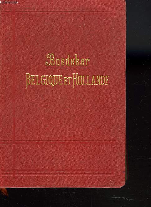
KARL BAEDEKER
BELGIQUE ET HOLLANDE YCOMPRIS LE LUXEMBOURG. MANUEL DU VOYAGEUR
BAEDEKER / OLLENDORFF. 1905. In-12. Cartonnage d'éditeurs. Etat d'usage, Couv. légèrement passée, Dos satisfaisant, Intérieur frais. 480 pages. Nombreuses cartes dépliantes en couleurs.. . . . Classification Dewey : 912-Atlas, cartes et plans
Referenz des Buchhändlers : R260113402
|
|
|
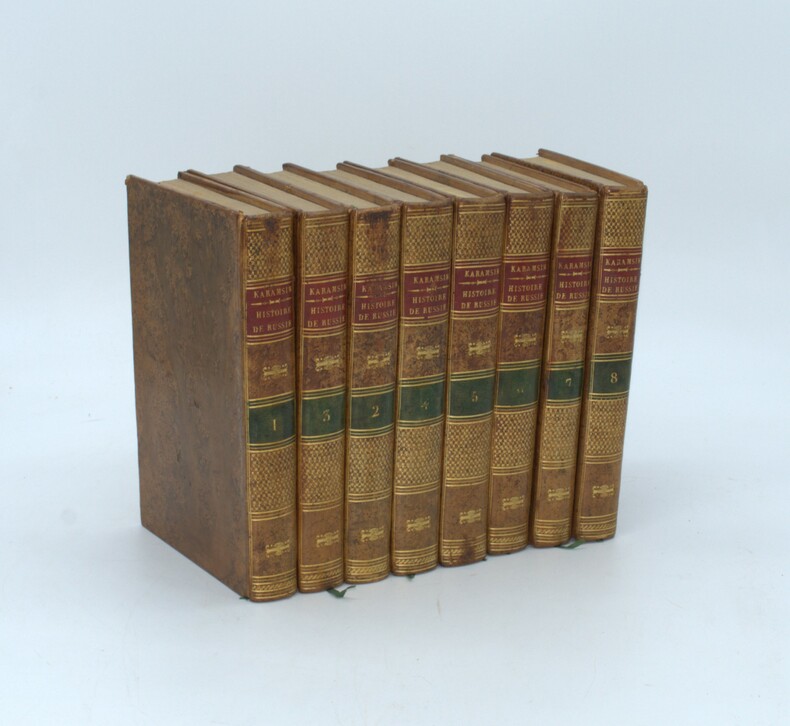
KARAMSIN, Nikolai Michailowitsch , ST. THOMAS , JAUFFRET (traducteurs)
Histoire de l'Empire de Russie. Traduite par MM. St.-Thomas et Jauffret
Paris, de l'imprimerie de A. Bélin, 1819 -1820 , 8 volumes in-8, relié pleine basane racinée, dos lisse avec pièce d’auteur et titre rouge et tomaison verte , tranches mouchetées jaunes, ex-libris au premier plat, trou de vers au tome 2 .
Referenz des Buchhändlers : PHO-1477
|
|
|
Karl Zieler Jacobis Atlas Der Hautkrankheiten
Lehrbuch und Atlas der Haut un Geschlechtskrankheiten für praktische Ärzte und Studierende. Auf Grundlage von Prof. Jacobis Atlas der Hautkrankheiten textlich vollständig neu bearbeitet I. Band: Text
Urban & Schwarzenberg 1934 in4. 1934. Cartonné.
Referenz des Buchhändlers : 100130229

|
|
|
KARL MULLER ( CAROLUS MULLERUS )
Strabonis Geographicorum Tabulae XV
1858 Paris, Firmin Didot 1858. In-8 broché,sans couvertures, IXp + 15 planches cartes dépliantes en couleurs. Peu courant. Bon état.
Referenz des Buchhändlers : 21467
|
|
|
Karl Heussi und Hermann Mulert
Atlas zur Kirchengeschichte. 66 Karten auf 12 Blättern. Zweite durchgelesehene Auflage.
Tübingen, Verlag von J.C.B.Mohr (Paul Siebeck), 1919. origi.Pappband, kl.4°, 18 Seiten und 12 Sätze im Anhang.
Referenz des Buchhändlers : 48583
|
|
|
KARL PEUCKER, (1859-1940).
[MAP] Karte von Bulgarien mit Ostrumelien und Tu?rk. Thrakien.; Mit kartographischen und statistischen Beilagen zum Versta?ndnis der orientalischen Krise.
Very Good German Original color map. Folded. A stamp of S. H. Weiss, Constantinople. Elephant folio. (82 x 65 cm). In German. Scale: 1/864.000. [MAP] Karte von Bulgarien mit Ostrumelien und Tu?rk. Thrakien.; Mit kartographischen und statistischen Beilagen zum Versta?ndnis der orientalischen Krise. Showing Bulgaria, Balkans, and Eastern Roumeli, and Turkish / Ottoman Thrace. A rare map. OCLC: 43528174.
|
|
|
Kast, Alfred (Hrsg. von Fraenkel, Eugen / Rumpel, Theodor)
Pathologisch-anatomische Tafeln nach frischen Präparaten
Leipzig, Verlag von Dr. Werner Klinkhardt, 1909. Gr.2°; Je Lieferung 4 Folio-Farbtafeln auf Kunstdruckpapier und Erläuterungen in Quartformat, in getrennter bzw. ohne Zählung (insg. 304 Seiten); [7 Warenabbildungen] ungebunden, in Originalmappe Halbleinen-Mappen lichtrandig, an Gelenken etwas angerissen; Innenbezug leiht stockfleckig; Papier der Begleittexte leicht gebräunt, vereinzelt stockfleckig; einzelne Tafeln fingerfleckig, meist sauber
Referenz des Buchhändlers : 56257

|
|
|
KATIB ÇELEBI (Haci Khalfa), (1609-1657).
The gift to the great ones on naval campaigns. (Tuhfetü'l-kibâr fi esfâri'l-bihâr). Edited by Idris Bostan. [With a CD].
New New English Original bdg. Dust wrapper. Folio. (32 x 25 cm). Edition in English. 463, [1] p., color ills. The gift to the great ones on naval campaigns. (Tuhfetü'l-kibâr fi esfâri'l-bihâr). Edited by Idris Bostan. [With a CD]. "It's a cost a joy of that the interest shown to the history and culture of sea has increased recently. If the sciencetific level of this interest is maintained, then how the Turks managed the seas in the best way will be understood better because each state grows to the extent of its interest in the seas and its power in the seas, and it takes its place among the navigator states thanks to the consciousness it develops". OTTOMANIA Ottoman history Military history Navigation Turkish naval forces Manuscript Atlas Map Collection Miniature Turkish and Islamic arts.
|
|
|
KATIP ÇELEBI, (Hadji Khalfa).
The book of Cihannuma: A 360 year old story.= Cihannüma: 360 yillik bir öykü. Edited by Bulent Özükan. Texts by Ibrahim Müteferrika, Orhan Kologlu, Mustafa Kaçar. English by Füsun Savci.
New New English Original bdg. Dust wrapper. In special publisher's box. 4to. (33 x 33 cm). In English and Turkish. 204 p., color ills., maps. The book of cihannuma: A 360 year old story.= Cihannüma: 360 yillik bir öykü. Edited by Bulent Özükan. Texts by Ibrahim Müteferrika, Orhan Kologlu, Mustafa Kaçar. English by Füsun Savci. A very heavy volume. 1950 copies were printed. OTTOMANIA First printing house Ottoman culture Collection Map Atlas World map.
|
|
|
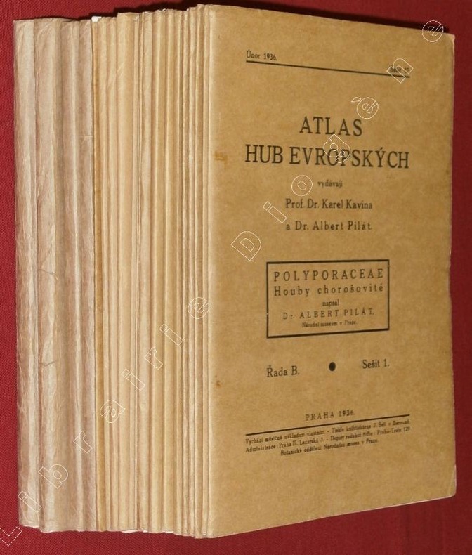
KAVINA, Karel - PILAT, Albert.
[Atlas des champignons de l'Europe]. Atlas Hub Evropskych : Polyporaceae, Houby chorosovité napsal Dr Albert Pilat. (20 fascicules)
Praha (Prague), 1936-42, 20 fascicules in-8 de 160x240 mm environ, 624 pages en 48 livraisons, accompagnées de 374 planches en noir et blanc (2 planches supplémentaires dans le fascicule 13-14), en feuillets sous chemises imprimées, réunies dans une chemise amateur cartonnée orange avec titres manuscrits. Edition originale. Texte en langue tchèque. Des plis sur le dos des 3 dernières chemises qui ont aussi les bordures fendillées, sinon bon état.
Referenz des Buchhändlers : 88917
|
|
|
Kayser, Heinrich
Lehrbuch der Spektralanalyse. Mit 87 Holzschnitten im Text und 9 lithogr. Tafeln.
Springer Verl. Berlin 1883. 23,1 : 15,1 cm. Originalhalbleinenband, etwas angestaubt, der hintere Deckel mit größeren (Fett-?)Flecken. XI, 358, (2) Seiten mit den 87 Textabbildungen und anhängend neun lithographierte Tafeln. Bezugspapier im vorderen Innengelenk gerissen, Bindung aber nur wenig gelockert. Im Innenbereich sauber, frei von Eintragungen. Die letze Tafel mittig auf der Rückseite stabilisiert. Gutes Exempar.
Referenz des Buchhändlers : 316098

|
|
|
KEELY S DIRECTORIES.
PLAN DE LONDRES DRAWN AND ENGRAVED EXPRESSLY.
CHEZ L AUTEUR.. 1907. In-8. Broché. Etat d'usage, Couv. convenable, Dos satisfaisant, Pliures. 75 cm / 108 cm. Carte entoilé en couleurs. Déchirures au niveau des pliures. Renforcé avec du scotch sur le dos.. . . . Classification Dewey : 912-Atlas, cartes et plans
Referenz des Buchhändlers : R150148702
|
|
|
KEELY S DIRECTORIES.
PLAN DE LONDRES DRAWN AND ENGRAVED EXPRESSLY.
CHEZ L AUTEUR.. 1907. In-8 Carré. Broché. Etat d'usage. Couv. convenable. Dos satisfaisant. Pliures. 75 cm / 108 cm. Carte entoilé en couleurs. Déchirures au niveau des pliures. Renforcé avec du scotch sur le dos.

|
|
|
Keller Heinrich
Première carte routière de la Suisse - Edition Originale de 1850
Chez l'auteur. 1850. In-Plano. En feuillets. Bon état, Couv. convenable, Dos satisfaisant, Intérieur frais. Carte dépliante de la Suisse en couleurs collée sur une toile (65 x 48 cm environ). Au verso, 12 petites cartes en couleurs (Plan des Rigibergs, Zürich bei H. Keller, La Suisse avec les distances, Charte des Gefichtskreises vom Rigi-Kulm, Basel, Bâme, Bern, Fribourg, Genève, Schaffhause, Lausanne...) + 2 encadrés de texte en allemand. Explication en allemand et en français. Le tout sous-emboîtage abîmé.. . Sous Emboitage. . Classification Dewey : 912-Atlas, cartes et plans
Referenz des Buchhändlers : R240164533
|
|
|
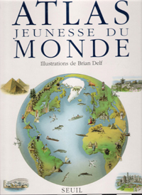
KEMP Richard, Illustré par BRIAN DELF
Atlas Jeunesse du Monde.
SEUIL. Oct. 1991. In-Folio. Cartonné. Bon état, Couv. fraîche, Dos satisfaisant, Intérieur frais. 80 pages. Nombreuses cartes et illustrations en couleurs, dans le texte.. . . . Classification Dewey : 912-Atlas, cartes et plans
Referenz des Buchhändlers : RO80117828 ISBN : 202012257
|
|
|
KEMP Richard
Atlas Jeunesse Du Monde ( the Children's Picture Atlas )
Paris Seuil 1991 In Plano Un regard neuf sur le monde : trouver où poussent les cactus candélabres , la longueur de la muraille de Chine , les différences entre l'Arctique et l'Antarctique , la structure de la terre et comment elle s'est formée , étudier un continent , un pays , une région , ses peuples , ses coutumes , ses industries et son agriculture etc...Cartes toutes en couleurs .- 80 p., 1 kg. 200
Referenz des Buchhändlers : 003952
|
|
|
KEMAL ÖZDEMIR.
Osmanli deniz haritalari ve Ali Macar Reis atlasi.
New New Turkish Original bdg. Dust wrapper. 4to. (33 x 23 cm). Edition in Turkish. 159, [1] p., color ills. Turkish Edition of the Ottoman nautical charts and the Atlas of Ali Macar Reis. 16th century Ottoman nautical charts figure significantly in the history of cartography. Dating from the time when the Ottoman Empire was approaching its zenith of wealth and power, these charts are a valuable source of information about the history of the period. The work of the Ottoman privateers who then held sway over most of the Mediterranean, these charts cover a geographical area far beyond the bounds of the Ottoman Empire. as rulers of an expanding empire, the Ottoman sultans took a close interest in mapmaking and may well have commissioned their sea captains to draw the charts. When Piri Reis presented his first world map to Sultan Selim I, conqueror of Egypt, in 1517, the sultan is said to have declared, "How small is the world for a conqueror.".
|
|
|
KEMAL ÖZDEMIR.
Ottoman nautical charts and the atlas of Ali Macar Reis.
Fine Fine English Original bdg. Dust wrapper. Folio. (33 x 23 cm). In English. 159, [1] p., color ills. Ottoman nautical charts and the Atlas of Ali Macar Reis. 16th century Ottoman nautical charts figure significantly in the history of cartography. Dating from the time when the Ottoman Empire was approaching its zenith of wealth and power, these charts are a valuable source of information about the history of the period. The work of the Ottoman privateers who then held sway over most of the Mediterranean, these charts cover a geographical area far beyond the bounds of the Ottoman Empire. as rulers of an expanding empire, the Ottoman sultans took a close interest in mapmaking and may well have commissioned their sea captains to draw the charts. When Piri Reis presented his first world map to Sultan Selim I, conqueror of Egypt, in 1517, the sultan is said to have declared, "How small is the world for a conqueror.". A very heavy volume.
|
|
|
KEMP Richard
Atlas Jeunesse Du Monde ( the Children's Picture Atlas )
Un regard neuf sur le monde : trouver où poussent les cactus candélabres , la longueur de la muraille de Chine , les différences entre l'Arctique et l'Antarctique , la structure de la terre et comment elle s'est formée , étudier un continent , un pays , une région , ses peuples , ses coutumes , ses industries et son agriculture etc...Cartes toutes en couleurs .- 80 p., 1 kg. 200
|
|
|
KENDALL Lt
1 CARTE MARITIME EN NOIR ET BLANC - AMERIQUE MERIDIONALE - copie du plan levé en 1828 - CARTE N°2043
***. 1943. In-Plano. En feuillets. Bon état, Couv. convenable, Dos satisfaisant, Intérieur frais. 1 carte en noir et blanc de 76 x 51 cm. Echelle 1/120000. Port Cook 1/36000.. . . . Classification Dewey : 912-Atlas, cartes et plans
Referenz des Buchhändlers : RO30092603
|
|
|
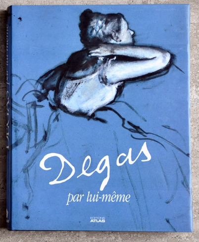
KENDALL (Richard) / DEGAS
DEGAS par lui meme
1987 Paris, Editions Atlas, 1987. In-folio cartonné noir, jaquette ill. 328 p. Très nombreuses illustrations en couleurs. Parfait état. Tableaux, dessins, extraits de la correspondance et des carnets de notes de Degas ainsi que des écrits des contemporains du peintre rassemblés par Richard Kendall.
Referenz des Buchhändlers : 5462
|
|
|
Kenneth W. Dobra; Lionas Miller; Alfred E. Browm; Ronald M. Atlas
Experimental Microbiology : Fundamentals and Applications
Benjamin-Cummings Publishing Company 1988. Paperback. Good. Disclaimer:A copy that has been read but remains in clean condition. All pages are intact and the cover is intact. The spine may show signs of wear. Pages can include limited notes and highlighting and the copy can include previous owner inscriptions. At ThriftBooks our motto is: Read More Spend Less.Dust jacket quality is not guaranteed. Benjamin-Cummings Publishing Company paperback
Referenz des Buchhändlers : G002304280XI3N00 ISBN : 002304280X 9780023042805

|
|
|
Keppel, Karl
Karl Keppels Geschichtsl-Atlas in 27 Karten.
München, Oldenbourg, (1904). 4° quer., Original-Broschur. 18. Auflage. (Umschlag eingerissen, eselsohrig).
Referenz des Buchhändlers : 305121AB
|
|
|
KERMABON Adh. JACQUEZ.-
Atlas des Lignes Télégraphiques Aériennes Construites en France de 1793 à 1852.-
Etabli d'après les ordres de Mr le Directeur Général des Postes et des Télégraphes Sous la direction de Mr Jacquez, Bibliothécaire de l'Administration Par Adh. Kermabon, Commis principal des Postes et des Télégraphes. Paris. 1892. In-plano (360 x 502 mm) cartonnage rouge d'éditeur imprimé et orné en noir, gardes bleues, 3ff., 48 cartes planimétriques en couleurs, montées sur onglets et très grande carte (ca 428 x 770 mm) des lignes télégraphiques aériennes de France 1793-1852. Mors du 1er plat fendu sur 21 cm, planche 33 (Gironde entièrement et uniformément brunie, sinon bel exemplaire malgré de tout petits défauts. De toute rareté.
Referenz des Buchhändlers : ORD-12168
|
|
|
KERGUELEN DE TREMAREC, Yves-Joseph Marie de.
Relation de deux voyages Dans les mers Australes & des Indes, faits en 1771, 1772, 1773 & 1774. Par M. De Kerguelen. Commandant les Vaisseaux du Roi le Berrier, la Fortune, le Gros-Ventre, le Rolland, l’Oiseau & la Dauphine. Ou Extrait du Journal de sa Navigation pour la découverte des terres Australes, & pour la vérification d’une nouvelle route proposée pour abréger d’environ huit cents lieues la traversée d’Europe à la Chine. Rare édition originale de ce voyage de découverte visant à prouver l’existence d’un continent austral, dont la plupart des exemplaires furent aussitôt mis au pilori.
Provenant de la Bibliothèque du Duc d’Aiguillon. A Paris, chez Knapen & Fils, Lib.-Imp. de la Cour des Aides, 1782. In-8 de viii pp., 244 pp., 1 carte dépliante hors-texte in-fine (Terres Australes ou Partie Septentrionale de l’Isle de Kerguelen), (2) ff. Plein veau glacé moucheté, filet à froid d’encadrement sur les plats, dos lisse orné de fleurons dorés, pièce de titre de maroquin vert, tranches rouges. Reliure de l’époque. 199 x 126 mm.
Referenz des Buchhändlers : LCS-18462

|
|
|
Kerrod, Robin
Das Kosmos-Buch vom Weltall / aus d. Engl. übers. von Hermann-Michael Hahn.
Stuttgart : Franckh-Kosmos, 1992. 95 S. : überw. Ill., Kt. Gr. 4°. Ill. OPpbd.
Referenz des Buchhändlers : 5331
|
|
|
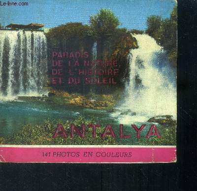
Keskin Naci
Paradis de la nature, de l'histoire et du soleil Antalya
Keskin Color. Non daté. In-12. Broché. Etat passable, Couv. légèrement passée, Dos frotté, Déchirures. Environ 100 pages augmentées de nombreuses photos en couleurs dans et hors texte.. . . . Classification Dewey : 912-Atlas, cartes et plans
Referenz des Buchhändlers : RO40010133
|
|
|
Kettermann, Günter
Atlas zur Geschichte des Islam [von Günter Kettermann], Mit einer Einleitung von Adel Theodor Khoury,
Darmstadt: Wissenschaftliche Buchgesellschaft (WBG) 2001. VI, 186 Seiten. Mit zahlreichen Abbildungen. Gr. 4° (33,5 x 25 cm). lllustrierter Orig.-Pappband. [Hardcover / fest gebunden].
Referenz des Buchhändlers : 5133200

|
|
|
Kettermann, Günter
Atlas zur Geschichte des Islam [von Günter Kettermann], Mit einer Einleitung von Adel Theodor Khoury,
Darmstadt: Wissenschaftliche Buchgesellschaft (WBG) 2001. VI, 186 Seiten. Mit zahlreichen Abbildungen. Gr. 4° (33,5 x 25 cm). lllustrierter Orig.-Pappband. [Hardcover / fest gebunden].
Referenz des Buchhändlers : 5136404

|
|
|
Kettermann, Günter
Atlas zur Geschichte des Islam.
Darmstadt: Wissenschaftliche Buchgesellschaft, 2001. VI + 186 S., Ill., graph. Darst., zahlr. Kt., 33 cm. Opp., gebundene Ausgabe.
Referenz des Buchhändlers : 225531

|
|
|
Kettermann, Günter
Atlas zur Geschichte des Islam.
Darmstadt: Wissenschaftliche Buchgesellschaft, 2001. VI + 186 S., Ill., graph. Darst., zahlr. Kt., 33 cm. Opp., gebundene Ausgabe.
Referenz des Buchhändlers : 215714

|
|
|
 Per e-mail erhalten
 Als pdf-Dokument herunterladen
 RSS feed


