|
SONNET H.
GEOMETRIE THEORIQUE ET PRATIQUE CONTENANT DE NOMBREUSES APPLICATIONS.ATLAS seul de
PARIS HACHETTE 1866;ATLAS seul de 86 planches,reliure IN8,demi basane,plats defraichis,rousseurs et mouillures
Référence libraire : 14916
|
|
|
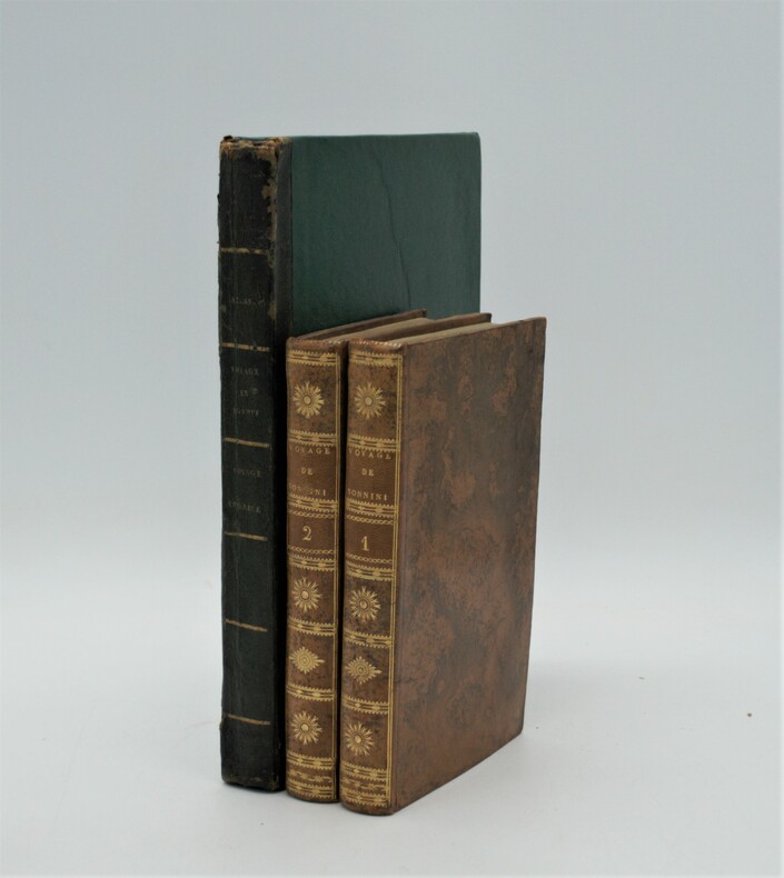
SONNINI De MANONCOURT, Charles Nicolas Sigisbert
Voyage dans la Haute et Basse Égypte [...] : Collection de Planches avecVoyage en Grèce et en Turquie, Fait Par Ordre De Louis XVI et avec l’Autorisation de la Cour Ottomane; par C.S. Sonnini, de plusieurs Sociétés Littéraires et Savantes de l’Europe, et des Sociétés d’Agriculture de Paris et des Observateurs de l’Homme.
Paris, Buisson, 1801 , in-4 ,une page de titre-1 f. non chiffré [Liste des planches]-1 très grande carte au contours coloréesh.-t. [980 x 1030 mm] et 6 planches h.-t. [I- VII] , réparations à la carte (Grèce) , mouillures , planche du Firman déchirée sans manque et mal pliée . avecParis, F. Buisson, An VII de la République (1798-1799). In-4, (2)-2 pp., 39 planches sous serpente et une carte ,déchirures à la carte sans manque (Égypte ) , trace de brunissure (carte) , mouillure sans atteinte aux planches.
Référence libraire : PHO-934
|
|
|
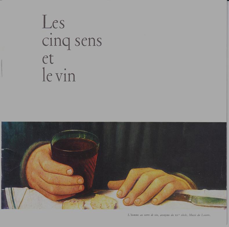
SOPEXA / Comité National des Vins de France
Les Cinq sens et le vin.
Paris : CNVF, s.d. Plaquette offerte par J. Janoueix, propriétaires à Libourne (Gironde), couverture couleur, [20 pages] illustrées couleur (photographies de Doisneau, Belzeaux, Chenot, Doumic/Atlas Photo, Schultess/Rapho, Musées Nationaux).
Référence libraire : SPN-594
|
|
|
Sorre (Max)
Les fondements biologiques de la géographie humaine. Essai d'une écologie de l'homme.
français Grand in-8 de 440 pp.; broché de l'éditeur.
|
|
|
Soufflard Thierry
"Où s'embrasser à Paris - Guide des meilleurs endroits (Collection ""Paris est à nous"")"
Parigramme. 1998. In-12. Broché. Bon état, Couv. légèrement pliée, Dos satisfaisant, Intérieur frais. 111 pages.. . . . Classification Dewey : 912-Atlas, cartes et plans
Référence libraire : RO80239566

|
|
|
SOULICE (Th.)
Atlas de Géographie à l'usage des Écoles, des Séminaires, des Maisons d'éducation accompagné de tableaux de géographie.
Paris, Langlois & Leclercq, (circa 1840). album in-8 oblong, titre & 25 cartes. Reliure de l'époque demi-basane aubergine.
Référence libraire : 27299

|
|
|
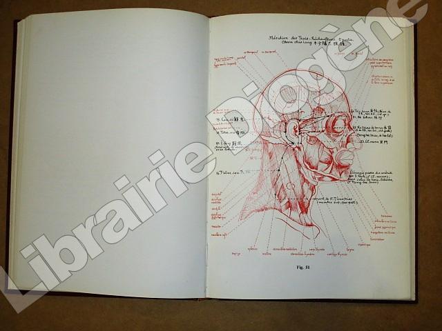
SOULIE DE MORANT George
L'acuponcture chinoise : atlas.
Maloine 1972 Maloine, 1972, 94 figures et 4 planches, cartonnage éditeur, environ 30x21cm, mors, coiffes et coins frottés, bon état pour le reste, intérieur bien propre.
Référence libraire : 97411
|
|
|
SOUS LA DIRECTION DE M.Mr BOURGEOIS & COLLECTIF
"CARTE ""ARRAS"" feuille XVII-7 mise à jour en Aout 1906"
HACHETTE. 1915. In-Plano. En feuillets. Bon état, Couv. convenable, Dos satisfaisant, Intérieur frais. Carte pliée mesurant 45cmx57cm à l'échelle 1/100.000. Carte en couleur. Quelques rousseurs.. . . . Classification Dewey : 912-Atlas, cartes et plans
Référence libraire : R240002042
|
|
|
SOUS LA DIRECTION DE M.Mr BOURGEOIS & COLLECTIF
"CARTE ""DOULLENS"" feuille XVII -8 mise à jour en Novembre 1901"
HACHETTE. 1915. In-Plano. En feuillets. Bon état, Couv. convenable, Dos satisfaisant, Intérieur frais. Carte pliée mesurant 45cmx57cm à l'échelle 1/100.000. Carte en couleur.. . . . Classification Dewey : 912-Atlas, cartes et plans
Référence libraire : R240002038
|
|
|
SOUS LA DIRECTION DE M.Mr LE GUAY & COLLECTIF
"CARTE ""BELFORT"" feuille XXVI-17 mise à jour en Décembre 1914"
HACHETTE. 1915. In-Plano. Cartonnage d'éditeurs. Bon état, Couv. convenable, Dos satisfaisant, Intérieur frais. Carte pliée mesurant 45cmx57cm à l'échelle 1/100.000. Carte en couleur. Quelques rousseurs.. . . . Classification Dewey : 912-Atlas, cartes et plans
Référence libraire : R240002044
|
|
|
SOUS LA DIRECTION DE M.Mr LE GUAY & COLLECTIF
"CARTE ""BELFORT"" feuille XXVI-18 mise à jour en Décembre 1904"
HACHETTE. 1916. In-Plano. En feuillets. Etat d'usage, Couv. convenable, Dos satisfaisant, Pliures. Carte pliée mesurant 45cmx57cm à l'échelle 1/100.000. Carte en couleur. Quelques rousseurs.. Quelques déchirures sur les pliures (n'altérant pas la lecture).. . . . Classification Dewey : 912-Atlas, cartes et plans
Référence libraire : R240002043
|
|
|
SOUS LA DIRECTION DE Mr CRISENOY & COLLECTIF
"CARTE ""ST QUENTIN"" feuille XVIII - 9 mise à jour en Aout 1907"
HACHETTE. 1916. In-Plano. En feuillets. Etat d'usage, Couv. convenable, Dos satisfaisant, Intérieur frais. Carte pliée mesurant 45cmx57cm à l'échelle 1/100.000. Carte en couleur. Quelques rousseurs, écriture au crayon de couleur. . . . Classification Dewey : 912-Atlas, cartes et plans
Référence libraire : R240002039
|
|
|
Space Age Atlas
Space Age Atlas
Rand McNally 1959-01-01. Hardcover. Very Good. Rand McNally hardcover
Référence libraire : 180423135
|
|
|
SPANISH MARITIME ATLAS LVENRN POUL de.
Samling af Kaart over Havne og Ankerpladse tilligemed Fortoninger henh�rende til Beskrivelsen over den spanske og portugisiske Kyst. Udgivet fra S�kort-Archivet.
K�benhavn 1819. Folio. 44 x 27 cm. Original blue wrappers with some dampstains and rear somewhat soiled. With the engraved oval title on upper wrapper. In a later hcloth portfolio. With 19 all engraved maps charts plans coastal profiles of which 7 are double-page. Maps numbered in letters A-K profiles numbered I-IX.The maps depicting the main harbours with townplans and anchorages. Maps with a few small marginal closed tears. � Extremely scarce Danish edition a compilation from Vicente Tofino's "Atlas Maritimo" where the sheets have Danish text. This maritime-atlas was probably intended to accompagny L�ven�rn's "Beskrivelse til det voxende Kaart over Kysterne af Spanien og Portugal." 1818.<br>Bibl. Danica II 362 a. 367. - Luisa Mart�n-Mer�s: Cat�logo anal�tico de los Atlas del Museo Naval de Madrid 2007". No 232. hardcover
Référence libraire : 56069

|
|
|
Spencer Katrina Atlas Project Manager
Oxford Atlas Project
Melbourne: Oxford U. P. 2010. reprint. stiff wrappers. Nice copy. quarto. 224pp. col. pls. & ills. col. maps CD included indexes Oxford U. P. unknown
Référence libraire : 330116
|
|
|
Spencer Katrina atlas Project manager
Oxford Atlas Project 3
Melbourne: Oxford University Press 2008. An unmarked unused copy with accompaning CD unused and intact. First. Paperback. Nr. Fine. 4to - over 9�" - 12" tall. Oxford University Press Paperback
Référence libraire : 022653 ISBN : 0195564510 9780195564518

|
|
|
Spielmann-Atlas / - Spielmann, Christian und Julius Krake
Historischer Atlas der Stadt Wiesbaden: zwölf digitalisierte Stadtkarten von Wiesbaden 1799 - 1910 ; CD-ROM und Begleitbuch. [hrsg. vom Magistrat der Landeshauptstadt Wiesbaden - Stadtarchiv]. ... Nachdruck der Ausgabe, Frankfurt a.M., Ruppert, 1912
Wiesbaden : Magistrat der Landeshauptstadt Wiesbaden, Kulturamt 2002. 1 CD-ROM : Kt. ; 12 cm + Begleitbuch (64 S. : mit Abb., Kt.) 265 x 285 mm Top Zustand, gebundene Ausgabe, Hardcover/Pappeinband
Référence libraire : 17455

|
|
|
SPIESS, Ernst:
Atlas mondial suisse. Edition 1997, revue et mise à jour.
Conférence des directeurs cantonaux de l’instruction publique, 1997, in-4to, VIII + 224 p., richement ill. de cartes couleurs, reliure en toile originale.
Référence libraire : 116663aaf
|
|
|
SPIESS, Ernst:
Schweizer Weltatlas. Nachgeführte Ausgabe 1997.
Konferenz der kantonalen Erziehzngsdirektoren, 1997, in-4to, VIII + 224 S., reich und farbige ill., Original-Pappband.
Référence libraire : 123806aaf
|
|
|
Spikmans.
Germania Inferior, Cartobibliografie van De Zeventien Provincies der Nederlanden 1548 ? 1831
, , 2024 hardcovers, Eerste druk, slechts 100 exemplaren, elk 1096 pagina?s, met: 410 historische landkaarten van de Nederlanden; 80 nieuwgevonden, eerder onbekende landkaarten; 200 nieuwe staten van eerder beschreven oude landkaarten; Twee delen, tezamen 1096 pagina?s; Gelimiteerde editie van 100 exemplaren; Bijzonder mooi gedrukt in full color FM raster, grootformaat hardcover: 230 x 320 mm ? 460 x 320 open; Genaaid gebonden, voorzien van leeslinten, soft touch.
Référence libraire : 65551
|
|
|
Spiridonova Atlas y otros
Curso Superior de Econom�a Pol�tica 2 tomos
Grijalbo 1965-01-01. paperback. Good. XXM5 - M�xico - 2 vol�menes - Vol�menes intonsos - Primera edici�n en espa�ol - Tomo I: Sociedades Presocialistas. Tomo II: Sociedades Socialistas - Traducci�n directa del ruso por Luis A. Vargas - Contienen 956 p�ginas entre los dos vol�menes - Ambos ejemplares r�sticos de origen mantienen sobrecubierta original de editorial - Puntas de lomo ligeramente gastadas - Buen estado Grijalbo paperback
Référence libraire : 33342
|
|
|
SPORCK José-A. et PIERARD Luc
Atlas de géographie, la Belgique, le Monde.
Bruxelles, Editions Asedi, 1968. 23 x 33, sans pagination, très nombreuses cartes en couleurs, reliure d'édition pleine toile , bon état.
Référence libraire : 73260
|
|
|
Sportsman's Atlas
Iowa Sportsman's Atlas Back Roads and Outdoor Recreations Containing Maps of Iowa's 99 Counties Public Lands in those Counties 911 Street Names Outdoor Opportunities and Amenities and Hotels and Motels
Sportsman's Atlas. Used - Good. Former Library book. Shows some signs of wear and may have some markings on the inside. Sportsman's Atlas unknown
Référence libraire : GRP78734477 ISBN : 0762553979 9780762553976
|
|
|
Sportsmans Atlas Co
Iowa Sportsman's Atlas Iowa
2003-08-02. Good. Ships with Tracking Number! INTERNATIONAL WORLDWIDE Shipping available. May not contain Access Codes or Supplements. May be re-issue. May be ex-library. Shipping & Handling by region. Buy with confidence excellent customer service! unknown
Référence libraire : 0762528117 ISBN : 0762528117 9780762528110

|
|
|
SPRECHER von BERNEGG / KLÜWER, Philipp:
Neue Karte des alpinen und verbündeten Rätien und seiner Untertanen / Georges Grosjean: Die Rätia-Karte von Fortunat Sprecher von Bernegg und Philipp Klüwer aus dem Jahre 1618.
Dietikon-Zürich, Verlag Bibliophile Drucke Josef Stocker, 1976, 52x65 cm. 4 S. Text, 1 faksim. Karte. Eines von 490 numm. Exemplaren (GA 530 Ex.). Ex. Nummer 90. Pappband-Mappe mit Leinen Rückenstreifen. (OHLn.-Mappe - Titelschild auf Umschlag vorne).
Référence libraire : 118961aaf
|
|
|
Sprigade, Paul und Max Moisel
Großer deutscher Kolonialatlas. Hrsg. von der Kolonialabtheilung des Auswärtigen Amts.
Reimer, Bln. 1901 - 1915 (Reprint!). Mit 39 (Falt-)Karten. Folio. OLwd. mit Goldprägung u. Schraubenbindung. Tadellos.
Référence libraire : 46723
|
|
|
Sprigade, Paul und Max Moisel
Großer deutscher Kolonialatlas. hrsg. von der Kolonialabtheilung des Auswärtigen Amts. Bearb. von Paul Sprigade und Max Moisel Neuaufl., Neudruck der Orig.-Ausg. Berlin, Reimer, Vohsen, 1901 - 1915
Köln : Komet [2014]. [59] Blatt : überw. Kt. ; 48 cm x 33 cm Gewebe, gebundene Ausgabe, Leinen, Exemplar in gutem Erhaltungszustand
Référence libraire : 53332

|
|
|
Sprigade, Paul, Max Moisel und Kolonialabtlg. d. Auswärtigen Amtes (Hrsg.)
Großer deutscher Kolonialatlas.
Köln : Komet (Lizenzausgabe), o. J. [2010]. Neuaufl., Neudr. der Orig.-Ausg. Berlin, Reimer, Vohsen, 1901 - 1915. [59] Bl. : überw. Karten ; 56 cm; roter Org.-Leinen
Référence libraire : 29700

|
|
|
SPRUNER Karol - MENKE Théodore
ATLAS ANTIQUUS. Karoli SPRUNERI Opus - Tertio Editit. Theodorus MENKE.
Sumtibus Justi Perthes Gothae 1865 Atlas in-folio ( 380 X 260 mm ), demi-maroquin rouge à coins, dos à nerfs orné de fleurons dorés ( Reliure de l'époque ). 17 pages de texte en allemand, imprimé sur 2 colonnes, avec 31 planches de cartes à double-page, montées sur onglets et délicatement rehaussées en couleur. Bel exemplaire.
Référence libraire : 919513

|
|
|
Spruner, K. von Dr
Historisch-Geographischer Schul-Atlas.
Gotha, Justus Perthes, 1856. gr. 8° quer; Zwei und zwanzig illuminierte Karten in Kupferstich; Regalsp. a. Fußschnitt, KEINE Schönheit! Bezahlung per PayPal möglich, we accept PayPal, Einb. stark beschabt u. stark bestoßen u. angeschmutzt mit Fehrlstellen, Seiten mit Eselsohren, fingerspurig, Schnitte angeschmutzt, altersbed. Bräunungen, starke Gebr.sp., Halbleinen
Référence libraire : 34901
|
|
|
Spruner, K[arl] von
Historisch-geographischer Atlas.
Holzminden, Reprint-Verlag-Leipzig, ca. 2001. 25 x 30 cm, unpaginiert, 46 Blätter, einseitig bedruckt, zahlreiche Karten, Halbleinen, Leinenecken, Deckel Kunstleder, goldgeprägter Deckeltitel. Reprintauflage der Originalausgabe, Gotha, Perthes kaum gebraucht, sehr gut erhalten.
Référence libraire : 20602AB
|
|
|
Spruner, Karl v
Historisch-geographischer Hand-Atlas zur Geschichte Asiens, Africa's, America's und Australiens. Achtzehn colorierte Karten nebst erläuternden Vorbemerkungen.
Gotha, Justus Perthes, 1853. Ca. 35 x 24,5 cm. 18 colorierte Karten. 12 Seiten Text. Halblederband der Zeit. [5 Warenabbildungen] Aus der Reihe: Spruner's historisch-geographischer Hand-Atlas, 3. Abtheilung.
Référence libraire : 53589AB

|
|
|
Spruner, Karl von
Historisch-Geographischer Hand-Atlas zur Geschichte Asiens, Africa's, America's und Australiens.
Gotha, Perthes, 1855. Zweite Aufl. Orig. gold- u. blindgepr. Ln.-Ebd. Titelbl. 11 S. sowie 18 grenzkolor. Stahlstich-Karten Quer-2°. Sehr gut erhalt., dekoratives Exemplar. Block gebrochen. Ebd. etw. fleck.
Référence libraire : 18692
|
|
|
Spruner, Karl von
Spruners historisch-geographischer Hand-Atlas Handatlas zur Geschichte der Staaten Europas vom Anfang des Mittelalters bis auf die neueste Zeit - 73 colorirte Karten
Gotha, Perthes, 1854. Hldr, Rücken gelöst, vorderes Gelenk gelockert, sonst gutes Exemplar, 2. Auflage
Référence libraire : 09794
|
|
|
Spruner, Karl von / Haenle, Siegfried
V. Spruners und Haenles Tabellen zur Geschichte der deutschen Staaten, Teil I.
Gotha, Justus Perthes, 1845. Brauner Halbleinenband der Zeit im Querformat 38 x 46 cm; Buchdeckel mit braun-beigen Marmorbezügen und Leinenecken. Großformatiges Tabellenwerk des Kartographen und Historikers Karl von Spruner (1803 - 1892) und des Regionalhistorikers und Juristen Siegfried Haenle (1814 - 1889) zur deutschen Geschichte. Mit XIX doppelseitigen chronologisch geordneten, nach Stämmen unterteilten Haupttabellen sowie XII Nebentabellen, die Texte zur Geographie und Genealogie sowie Stammtafeln enthalten, ferner mit einer grenzkolorierten Deutschlandkarte. Der vorliegende Band reicht von den "ältesten Zeiten" bis zum Vertrag von Verdun im Jahre 843.
Référence libraire : SB-17177

|
|
|
Stace, Alexa, Anne Emmert und Julian Baker
Die Erde : faszinierende Weltraumfotos von unserem blauen Planeten zeigen die Vielfalt und Lebendigkeit der Natur. (Entdecke unsere Welt). 1. Aufl.
Würzburg : Arena, 2000. 96 S. : Ill., graph. Darst. Gebundene Ausgfabe, OPp.
Référence libraire : 166851

|
|
|
Stackebrandt Werner., Ehmke Gerhard., Manhenke Volker (hrsg.)
Atlas zur Geologie von Brandenburg im Maßstab 1:1 000 000 gewidmet Dr.habil Günther Schwab dem ersten Direktor des Landesamtes für Geowissenschaften und Rohstoffe Brandenburg
Kleinmachnow (Landesamt für Geowissenschaften und Rohstoffe Brandenburg) 1997 (= Erste Ausgabe). Quer-2°, illustrierte Originalspiralheftung (Paperback), 80 S., farbige Karten, ISBN 3000022112 1
Référence libraire : Khe00410
|
|
|
Staff Dresser Atlas
Dresser Atlas Spectralog
Tight squared copy crisp unmarked text; light discoloration page edges name penned on cover overall minor outer wear. Dresser Industries paperback
Référence libraire : 19342-RF

|
|
|
Standard Atlas Company Review and Herald Publishing Association
Oceana County Michigan : topography biography history art folio and directory of freeholders from recent surveys official records and personal examinations : showing its development in the first forty years since its organization 1895 Leather Bound
2019. Leather Bound. New. Leather Binding on Spine and Corners with Golden Leaf Printing on round Spine. Reprinted in 2019 with the help of original edition published long back 1895. This book is printed in black & white sewing binding for longer life Printed on high quality Paper re-sized as per Current standards professionally processed without changing its contents. As these are old books we processed each page manually and make them readable but in some cases some pages which are blur or missing or black spots. If it is multi volume set then it is only single volume if you wish to order a specific or all the volumes you may contact us. We expect that you will understand our compulsion in these books. We found this book important for the readers who want to know more about our old treasure so we brought it back to the shelves. Hope you will like it and give your comments and suggestions. Lang: - eng Pages 87. EXTRA 10 DAYS APART FROM THE NORMAL SHIPPING PERIOD WILL BE REQUIRED FOR LEATHER BOUND BOOKS. FOLIO EDITION IS ALSO AVAILABLE. hardcover
Référence libraire : LB1111002244704
|
|
|
Standard Atlas Company.
Oceana County Michigan : topography biography history art folio and directory of freeholders from recent surveys official records and personal examinations : showing its development in the first forty years since its organization. 1895
2020. Paperback. New. Lang: - eng Pages 87. Reprinted in 2020 with the help of original edition published long back 1895. This book is Printed in black & white sewing binding for longer life with Matt laminated multi-Colour Soft Cover HARDCOVER EDITION IS ALSO AVAILABLE Printed on high quality Paper re-sized as per Current standards professionally processed without changing its contents. As these are old books we processed each page manually and make them readable but in some cases some pages which are blur or missing or black spots. If it is multi volume set then it is only single volume if you wish to order a specific or all the volumes you may contact us. We expect that you will understand our compulsion in these books. We found this book important for the readers who want to know more about our old treasure so we brought it back to the shelves. Any type of Customisation is possible with extra charges. Hope you will like it and give your comments and suggestions. paperback
Référence libraire : PB1111011554279
|
|
|
Standard Atlas Company.
Oceana County Michigan : topography biography history art folio and directory of freeholders from recent surveys official records and personal examinations : showing its development in the first forty years since its organization. 1895 Hardcover
2020. Hardcover. New. Lang: - eng Pages 87. Reprinted in 2020 with the help of original edition published long back 1895. This book is Printed in black & white Hardcover sewing binding for longer life with Matt laminated multi-Colour Dust Cover Printed on high quality Paper re-sized as per Current standards professionally processed without changing its contents. As these are old books we processed each page manually and make them readable but in some cases some pages which are blur or missing or black spots. If it is multi volume set then it is only single volume if you wish to order a specific or all the volumes you may contact us. We expect that you will understand our compulsion in these books. We found this book important for the readers who want to know more about our old treasure so we brought it back to the shelves. Any type of Customisation is possible with extra charges. Hope you will like it and give your comments and suggestions. hardcover
Référence libraire : 1111011554279
|
|
|
Standard Atlas Company Review and Herald Publishing Association
Oceana County Michigan : topography biography history art folio and directory of freeholders from recent surveys official records and personal examinations : showing its development in the first forty years since its organization 1895 Hardcover
2020. Hardcover. New. Lang: - eng Pages 87. Reprinted in 2020 with the help of original edition published long back 1895. This book is Printed in black & white Hardcover sewing binding for longer life with Matt laminated multi-Colour Dust Cover Printed on high quality Paper re-sized as per Current standards professionally processed without changing its contents. As these are old books we processed each page manually and make them readable but in some cases some pages which are blur or missing or black spots. If it is multi volume set then it is only single volume if you wish to order a specific or all the volumes you may contact us. We expect that you will understand our compulsion in these books. We found this book important for the readers who want to know more about our old treasure so we brought it back to the shelves. Any type of Customisation is possible with extra charges. Hope you will like it and give your comments and suggestions. hardcover
Référence libraire : 1111002244704
|
|
|
Standard Atlas Company Review and Herald Publishing Association
Oceana County Michigan : topography biography history art folio and directory of freeholders from recent surveys official records and personal examinations : showing its development in the first forty years since its organization 1895
2020. Paperback. New. Lang: - eng Pages 87. Reprinted in 2020 with the help of original edition published long back 1895. This book is Printed in black & white sewing binding for longer life with Matt laminated multi-Colour Soft Cover HARDCOVER EDITION IS ALSO AVAILABLE Printed on high quality Paper re-sized as per Current standards professionally processed without changing its contents. As these are old books we processed each page manually and make them readable but in some cases some pages which are blur or missing or black spots. If it is multi volume set then it is only single volume if you wish to order a specific or all the volumes you may contact us. We expect that you will understand our compulsion in these books. We found this book important for the readers who want to know more about our old treasure so we brought it back to the shelves. Any type of Customisation is possible with extra charges. Hope you will like it and give your comments and suggestions. paperback
Référence libraire : PB1111002244704
|
|
|
STANFORD (Edward)
Complete Atlas of China - Containing separate Maps of the Eighteen Provinces of China Proper on the scale of 1:3,000,000 and of the Four Great Dependencies on the scale of 1: 7,500,000 together with an Index to all the Names on the Maps with the Latitude and Longitude of each Place, all Railways, Telegraph Stations, Ports & Protestant Mission Stations Marked - Second Edition prepared by Mr Edward Stanford for The China Inland Mission.
The China Inland Mission, London,Philadelphia, Toronto, Melbourne, Shanghai, 1917 (second edition). 1 volume folio, v-22 pp. (maps) - 16 pp. (index), with 22 large double-page colour maps, rebound in modern full leather, a very good copy .
Référence libraire : 11554
|
|
|
STANLEY V TUCKER NEIL E ATLAS
Stanley v. Tucker Petitioner v. Peoples Savings Bank Bridgeport. U.S. Supreme Court Transcript of Record with Supporting Pleadings
Gale U.S. Supreme Court Records 2011-10-30. Paperback. Good. Gale, U.S. Supreme Court Records paperback
Référence libraire : SONG1270671790 ISBN : 1270671790 9781270671794
|
|
|
Stark David;Vanel Daniel;Atlas Scott W.
Imaging Strategies In Oncology
New York New York U.S.A.: Wiley-Liss 1993. hardcover in very good condition. Hardcover. Very Good. New York, New York, U.S.A.: Wiley-Liss Hardcover
Référence libraire : 11385 ISBN : 047159069X 9780471590699

|
|
|
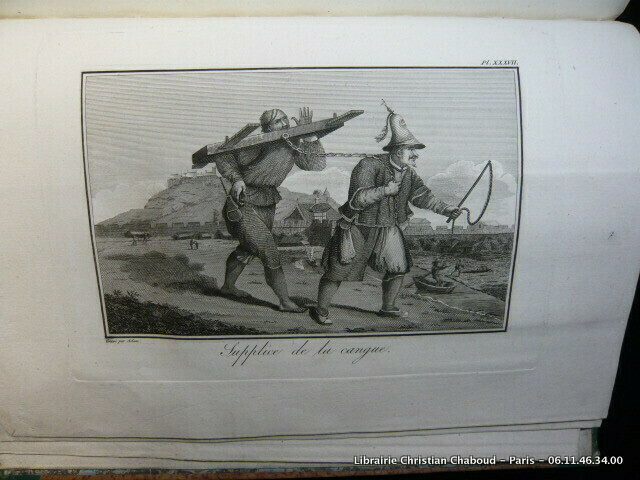
STAUNTON Georges, MACARTNEY
ATLAS DE MACARTNEY. VOYAGE DANS L'INTERIEUR DE LA CHINE ET EN TARTARIE FAIT DANS LES ANNÉES 1792, 1793 et 1794. Collection de 37 planches et 4 cartes (dont 3 dépliantes) par Tardieu. 3e édition. (Atlas seul).
Paris, Chez F. Buisson, AN XII (1804), in-4 (22X30cm) , demi-basane d'époque à dos long, pièces de titre (légers frottements), Très bel exemplaire. Planches et cartes de toute fraîcheur, sans déchirure.
Référence libraire : 69614
|
|
|
STAUNTON (sir John) - Castera (J.) [Traducteur] - [AMBASSADE DE MACARTNEY]
Voyage dans l'intérieur de la Chine et en Tartarie, fait dans les années 1792,1793 et 1794, par Lord Macartney, Ambassadeur du Roi d'Angleterre auprès de l'Empereur de Chine; Rédigé sur les papiers de Lord Macartney, sur ceux du Commodore Erasme Gower, et des autres Personnes attachées à l'Ambassade; Par Sir Georges Staunton, de la Société Royale de Londres, Secrétaire de l'Ambassade d'Angleterre, et Ministre plénipotentiaire auprès de l'Empereur de Chine; Traduit de l'anglais, avec des notes, par J. Castera. 5 volumes de texte et 1 Atlas in quarto.
A Paris, Chez F. Buisson, Imprimeur-Libraire, An XII (1804). 5 volumes de texte, reliure plein veau, plats ornés de liserés, dos ornés, très beaux exemplaires et 1 volume d'atlas in quarto, reliure moderne demi-maroquin à coins, plats cartonnés marbrés, comportant une collection de 37 Planches et 4 Cartes dessinées à Londres, et gravées en taille-douce par Tardieu l'aîné, excellent état.
Référence libraire : 9476
|
|
|
STEDMAN Capitaine John Gabriel.-
Voyage à Surinam, et dans l'intérieur de la Guiane, contenant la rellation de cinq Années de Courses et d'Observations faites dans cette contrée intéressante et peu connue; Avec des détails sur les Indiens de la Guiane
et les Nègres. Traduit de l'anglais par P. F. Henry. ATLAS seul.- Paris. Buisson. An VII de la République (1799). 1 volume in-4 (214 x 282 mm) dos à 5 nerfs et coins veau fauve, doubles filets dorés, pièces de titres maroquin rouge et noir, complet des 44 planches, certaines rempliées. Signature manuscrite sur la page de titre Stanislas Grabowski 1799. Quelques rousseurs pâles essentiellement marginales, reliure un peu frottée, petits défauts d'usage, planches en bon état.
Référence libraire : ORD-19735
|
|
|
STEFANO INDIVERI.
CARTE DEPLIANTE DE ROMA. PIANTA PANORAMICA.
CHEZ L AUTEUR.. 1963. In-8. Broché. Bon état, Couv. convenable, Dos satisfaisant, Intérieur frais. Carte dépliante de 49.5 cm / 69.5 cm.. . . . Classification Dewey : 912-Atlas, cartes et plans
Référence libraire : R150147501
|
|
 Recevoir par e-mail
 Télécharger en PDF
 Flux RSS


