|
STRABON [ESTRABÓN].
Rerum Geographicarum Libri Septemdecim?
Basileae, Hericpetrina, (Al fin:) 1571, 33 x 21,5 cm., pergamino de época, lómo pintado y rotulado, 3 hojas + 1 hoja blanca + 52 hojas + 977 págs. de texto griego-latín en columnas paralelas, incluso 27 mapas plegados y otros 7 mapas pequeños intercalados en el texto + 1 hoja con la marca del impresor. (Firma de anterior propietario en portada. Variante muy rara de la primera edición ilustrada de Geographia de Estrabon. En esta variante, el nombre del editor Guilielmus Xylander [Wilhelm Holzman] se omite del título. Xylander, un conocido erudito griego, escribió los comentarios para esta edición y tradujo el texto griego original al latín. Esta obra se considera una de las primeras geografías científicas. Contiene veintisiete mapas a doble página grabados por Sebastian Münster y siete mapas más pequeños, Eubea, Creta, Lesbos, Rodas, Chipre, Cefalonia y África, atribuidos a Johann Honter y otros. El impresor Sebastian Henricpetri fue heredero del sucesor de Sebastian Münster y por ello pudo utilizar los bloques xilográficos de los mapas de Münster para la Geografía de Tolomeo y "De Cosmographia Rudimentis" de Honter. No hemos localizado ningún ejemplar de esta variante en el Worldcat). {Basel Ex Oficina Henricpetrina, [at end:] 1571. 3ll, + 1bl, 52ll. 977pp. colophon on p. 977v +1l. with Printer?s device on verso with no other text. 27 double page maps and 7 smaller maps in text. Text in Greek and Latin printed in parallel columns. Contemporary vellum with the spine painted and decorated. Signatures of previous owners on title page. Very rare variant of the first illustrated edition of Strabo?s Geographia. In this variant the name of the editor Guilielmus Xylander (Wilhelm Holzman; 1532?-1576) is omitted from the title. Xylander, a well-known Greek scholar, wrote commentaries for this edition and translated the original Greek text into Latin. Strabo was a Greek geographer of the early Roman Empire. His Geographia was based on his own direct observations and information that he had gathered from others. It is regarded as one of the earliest scientific geographies. It contains twenty-seven double-page engraved maps by Sebastian Münster and seven smaller maps (Euboea, Crete, Lesbos, Rhodes, Cyprus, Cephalonia and Africa) attributed to Johann Honter and others. The printer Sebastian Henricpetri (1546-1627) was heir of the successor of Sebastian Münster and for this reason was able to use the xylographic blocks of Münster?s maps for Ptolomy´s Geographia and for Honter´s De Cosmographia Rudimentis (1561). No copies of this variant of Strabo´s Geographia in Worldcat. Adams 1907 (standard edition); Phillips, A List of Geographical Atlases in the Library of Congress, Washington, 1914, vol. III, 3390, pp. 78-79 (standard edition)}.
|
|
|
STRABON.
Rerum Geographicarum Libri Septemdecim ?
Basel Ex Oficina Henricpetrina, [at end:] 1571. 3ll, + 1bl, 52ll. 977pp. colophon on p. 977v +1l. with Printer?s device on verso with no other text. 27 double page maps and 7 smaller maps in text. Text in Greek and Latin printed in parallel columns. Contemporary vellum with the spine painted and decorated. Signatures of previous owners on title page. Very rare variant of the first illustrated edition of Strabo?s Geographia. In this variant the name of the editor Guilielmus Xylander (Wilhelm Holzman; 1532?-1576) is omitted from the title. Xylander, a well-known Greek scholar, wrote commentaries for this edition and translated the original Greek text into Latin. Strabo was a Greek geographer of the early Roman Empire. His Geographia was based on his own direct observations and information that he had gathered from others. It is regarded as one of the earliest scientific geographies. It contains twenty-seven double-page engraved maps by Sebastian Münster and seven smaller maps (Euboea, Crete, Lesbos, Rhodes, Cyprus, Cephalonia and Africa) attributed to Johann Honter and others. The printer Sebastian Henricpetri (1546-1627) was heir of the successor of Sebastian Münster and for this reason was able to use the xylographic blocks of Münster?s maps for Ptolomy´s Geographia and for Honter´s De Cosmographia Rudimentis (1561). No copies of this variant of Strabo´s Geographia in Worldcat. Adams 1907 (standard edition); Phillips, A List of Geographical Atlases in the Library of Congress, Washington, 1914, vol. III, 3390, pp. 78-79 (standard edition).
|
|
|
Straka, Manfred. (wissenschaftliche und kartographische Redaktion)
Atlas der Steiermark.
Graz., Akademische Druck- und Verlagsanstalt., 1970. Herausgegeben von der Steiermärkischen Landesregierung unter Mitarbeit des Naturwissenschaftlichen Vereines für Steiermark. Die Karten sind datiert von 1953 - 1970. Enthält 19 ausfaltbare Karten, 71 Kartenseiten , meist farbig, teilweise mehrere Karten pro Seite. Außerdem Titelblatt, Verzeichnis der Mitarbeiter. Übersicht der Karten, der Steirischen Gemeinden( 2 Blätter). Zusammen 94 Blätter. Verzeichnet geographische Karten, Karten zu Oberflächenformen, Klima und Phänologie, Böden, Vegetation, Tierwelt, Bevölkerungsverteilung und -entwicklung, historische Entwicklung , Siedlungsformen, Mundarten, Land- und Forstwirtschaft, Energiewirtschaft, Industrie, Handel und Gewerbe, Verkehr, Fremdenverkehr, Verwaltung, Kultur.; Zustand: Aus einer Institutsbibliothek ausgeschieden, Einbandränder leicht berieben, Einbanddeckel gestempelt, Vorsatzblatt und vereinzelt Kartenrückseiten ebenfalls gestempelt, die Lochung (Ringbuch) ist bei den ersten Karten minimal eingerissen. Der erst 1973 eschienen Band: Erläuterungen zum Atlas der Steiermark , fehlt. Quer - 50 x 36 cm. S OHalbkunstleder - Ringordner.
書籍販売業者の参照番号
: 041951
|
|
|
Streit, F.W
Atlas von Europa in zwei und achtzig Blättern.
Natorff, Bln. 1837. Mit gestochenem Titel, 78 grenzkolorierte Kupfersticharten u. 4 gestochenen Übersichten. Quer-4°. Hldr.d.Zt. Berieben u. bestossen. Durchgehend wenig bis stärker stockfleckig. Die "Spanien und Portugal" Karten sind numerisch falsch eingebunden.
書籍販売業者の参照番号
: 45186
|
|
|
Strittmatter, Beate
Taschenatlas Ohrakupunktur nach Nogier-Bahr - Grundlagen - Lokalisationen - Indikationen,
Stuttgart, Hippokrates-Verlag, 2008. 8°, XXI, 413 S. mit 384 s/w-Illustrationen, original Kartonage (Paperback), 4., aktualisierte Auflage Einband im Rückenbereich ein wenig aufgehellt, Vorderdeckel mit einem kleinen, Rückdeckel mit einem winzigen Eckknick, Rücken mit einem Längsfältchen, sonst ein gutes Exemplar ohne Anstreichungen, ohne Vorbesitzvermerke, ohne Eckknicke etc.
書籍販売業者の参照番号
: 17573BB

|
|
|
STUDENT WORLD ATLAS
Student World Atlas
DK. PAPERBACK. 024119914X Brand new book.Buy with confidence. Money Back Guarantee.Expedite Shipping Available. International shipment available. . New. DK paperback
書籍販売業者の参照番号
: ABYS06792 ISBN : 024119914X 9780241199145
|
|
|
Stülpnagel, F. von; Bär, J. C. (entworfen und gezeichnet)
Eisen-Bahn-Atlas von Deutschland, Belgien, Elsass und dem nördlichsten Theile von Italien. In zehn Specialkarten und einer Übersichtskarte.
Holzminden, Ursula Hinrichsen Verlag, 1985. gr. 8°, Faksimile-Druck der Ausgabe von 1847 in einer Auflage von 500 Ex., Bezahlung per PayPal möglich , we accept PayPal, min. gebr.sp., Halbleinen
書籍販売業者の参照番号
: 22147
|
|
|
SULLIVAN CATHERINE; ATLAS COURTNEY
HEALTH CARE FOOD SERVICE SYSTEMS MANAGEMENT
Aspen 1998-01-15. Paperback. New. Aspen paperback
書籍販売業者の参照番号
: 180519050 ISBN : 0834209217 9780834209213

|
|
|
Sundhaußen, Ellen, Günter W. Korting und C. E. Orfanos
Moulagen. Moulages. In deutscher u. engl. Sprache.
Berlin: Diesbach 1987. Mit zahlr. ganzseitigen, farb. Abb. 151 S. Pp. m. Schutzumschlag. 27x27 cm.
書籍販売業者の参照番号
: 39268

|
|
|
Survey, Ordnance
Barra and Vatersay / Barraigh Agus Bhatarsaigh : Eriskay & Mingulay / Eirisgeigh agus Miughlaigh ; the essential map for outdoor activities.
s.l. : Ordnance Survey, 2007. Gr. 8°. Folded map. (OS Explorer Map ; 452)
書籍販売業者の参照番号
: 35316
|
|
|
Susan Atlas
Passover Passage
Torah Aura Productions 1991. Paperback. Good. Disclaimer:A copy that has been read but remains in clean condition. All pages are intact and the cover is intact. The spine may show signs of wear. Pages can include limited notes and highlighting and the copy can include previous owner inscriptions. At ThriftBooks our motto is: Read More Spend Less.Dust jacket quality is not guaranteed. Torah Aura Productions paperback
書籍販売業者の参照番号
: G0933873468I3N00 ISBN : 0933873468 9780933873469
|
|
|
Susan Atlas
The Passover Passage
Torah Aura Productions. Paperback. GOOD. Spine creases wear to binding and pages from reading. May contain limited notes underlining or highlighting that does affect the text. Possible ex library copy will have the markings and stickers associated from the library. Accessories such as CD codes toys may not be included. Torah Aura Productions paperback
書籍販売業者の参照番号
: 3199572380 ISBN : 0933873468 9780933873469
|
|
|
Susan Atlas
The Passover Passage
Torah Aura Productions. Used - Very Good. Very Good condition. Torah Aura Productions unknown
書籍販売業者の参照番号
: S18A-02166 ISBN : 0933873468 9780933873469
|
|
|
Susan Atlas
The Passover Passage
Torah Aura Productions 1989-06-01. Paperback. Used:Good. Torah Aura Productions paperback
書籍販売業者の参照番号
: DADAX0933873468 ISBN : 0933873468 9780933873469
|
|
|
Susan Jane Cheney Nava Atlas
Stir Crazy! : More than 100 Quick Low-Fat Recipes for Your Wok or Stir-Fry Pan
McGraw-Hill. Paperback. GOOD. Spine creases wear to binding and pages from reading. May contain limited notes underlining or highlighting that does affect the text. Possible ex library copy will have the markings and stickers associated from the library. Accessories such as CD codes toys may not be included. McGraw-Hill paperback
書籍販売業者の参照番号
: 3199232396 ISBN : 0809230011 9780809230013

|
|
|
Susan Jane Cheney Nava Atlas
Stir Crazy! : More than 100 Quick Low-Fat Recipes for Your Wok or Stir-Fry Pan
McGraw-Hill 1998-04-01. 1. Paperback. Used:Good. McGraw-Hill paperback
書籍販売業者の参照番号
: DADAX0809230011 ISBN : 0809230011 9780809230013
|
|
|
Susan Jane Cheney; Nava Atlas
Stir Crazy! : More than 100 Quick Low-Fat Recipes for Your Wok or Stir-Fry Pan
McGraw-Hill 1998-04-01. Paperback. Very Good. McGraw-Hill paperback
書籍販売業者の参照番号
: SONG0809230011 ISBN : 0809230011 9780809230013
|
|
|
SVAT SOUCEK, MUSTAFA KAÇAR, DOGAN UÇAR, GREGORY C. MC INTOSH, GÜNSEL RENDA, CEVAT ÜLKEKUL, A. M. CELAL SENGÖR.
Pîrî Reis 1513 dünya haritasi. XIII. yy. sonrasi Islâm-Osmanli haritaciligi. Edited by Bülent Özükan.
New English In original cloth bdg. In publisher's original slip-case and box. Elephant folio. (48 x 33 cm). In Turkish. Many color and b/w ills. 264 p. 1513 World atlas of Piri Reis. A very heavy volume. Pîrî Reis 1513 dünya haritasi. XIII. yy. sonrasi Islâm-Osmanli haritaciligi. Edited by Bülent Özükan.
|
|
|
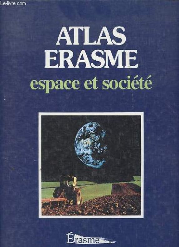
Swysen L., Seret G.
Atlas Erasme - Espace et société.
Erasme. 1998. In-4. Broché. Etat d'usage, Couv. légèrement pliée, Coiffe en tête abîmée, Papier jauni. 127 pages, nombreuses cartes en couleur hors texte - annotation à l'encre sur la page de garde.. . . . Classification Dewey : 912-Atlas, cartes et plans
書籍販売業者の参照番号
: R200134226
|
|
|
SYDOW, E. v
Schul-Atlas in 38 Karten. 6, Aufl.
Gotha: Perthes 1854. 5 ungez. + 36 meist grenzkol. lith. af. mit 38 Karten Quer 8° HLdr. *1 Kartenblatt lose, Rücken bestossen, braunfleckig* Rücken fehlt zu 1/3*.
書籍販売業者の参照番号
: 1402
|
|
|
Sydow, E. von
Sydows Schul-Atlas Schulatlas in zwei und vierzig Karten
Gotha, Perthes, 1859. PP, Block gebrochen, Karten teilw. gelöst, angerändert und teilw. fleckig, 11.Auflage
書籍販売業者の参照番号
: 09897
|
|
|
SYMES MICHAEL.
Relation de l’ambassade anglaise, envoyée en 1795 dans le royaume d’Ava, ou l’empire des Birmans.
Paris, Buisson, 1804. In-folio (37x28 cm) cartonnage orangé, non rogné (Reliure de l’époque). 2ff- 2 cartes dépliantes – 28 planches. Atlas seul, contenant deux cartes dépliantes et 28 planches de costumes, vues et histoire naturelle, gravées en taille-douce par Tardieu, Delignon, Niquet et Delvaux. Cartonnage un peu frotté, dos manquant, mais intérieur bien frais. Non rogné, sans les 3 volumes de texte. Atlas of the French translation “an account of an embassy to the kingdom of Ava”, 2 folding maps and 28 plates bound in contemp. board, binding worn, the plates are very clean, no foxing or water stain. Size folio (37x28 cm).
書籍販売業者の参照番号
: P1-4D-4
|
|
|
SYMES MICHAEL.
Relation de l’ambassade anglaise, envoyée en 1795 dans le royaume d’Ava, ou l’empire des Birmans.
Paris, Buisson, 1804. 3 volumes de texte in-8, reliés pleine basane époque, dos lisse ornés, pièce de titre maroquin rouge et de tomaison verte, tranches marbrées, filets or sur les plats, reliure frottée, coins émoussés. 396,375 et 318pp.(reliure T3 diff.) Un ATLAS in-folio (37x28 cm), relié demi-basane à coins, dos plat orné, manque de cuir au dos, reliure usagée, intérieur en bon état, pas de rousseurs. 2ff- 2 cartes dépliantes 28 planches. Illustré de deux cartes dépliantes et 28 planches de costumes, vues et histoire naturelle, gravées en taille-douce par Tardieu, Delignon, Niquet et Delvaux. Atlas of the French translation an account of an embassy to the kingdom of Ava , 2 folding maps and 28 plates half contemporary bounding, binding worn, the plates are very clean, no foxing or water stain. Size folio (37x28 cm). 3 volumes of text (binding vol.3 diff.)
書籍販売業者の参照番号
: P1-5CP1-4D
|
|
|
Symes (Michael).
Relation de l'Ambassade Anglaise envoyée en 1795 dans le Royaume d'Ava, ou l'Empire des Birmans, par le Major Michel Symes, chargé de cette Ambassade. Suivie d'un Voyage fait, en 1798, à Colombo, dans l'Ile de Ceylan, et à la Baie de Da Lagoa, sur la côte orientale de l'Afrique; de la Description de l'Ile de Carnicobar et des Ruines de Mavalipouram, traduits de l'anglais avec des notes par J. Castera.
Paris, Buisson, 1800. 3 volumes in-8 de (4)-VII-(1)-380 pp. ; (4)-396 pp. ; (4)-318 pp., 1 atlas grand in-folio de (4) pp. (titre et liste des planches), 2 cartes repliées et 28 planches numérotées I-XXX, demi-veau havane, pièces de titre en maroquin vert et de tomaison en maroquin rouge, frises et filet d'encadrement dorés, et pour l'atlas demi-veau havane à coins, dos lisse orné, pièces de titres en maroquin vert (reliure de l'époque).
書籍販売業者の参照番号
: 40670

|
|
|
SYNDICAT D'INITIATIVE
Carte dépliante de Saint-Médard-en-Jalles.
CHEZ L'AUTEUR. Non daté. In-12. En feuillets. Bon état, Couv. convenable, Dos satisfaisant, Intérieur frais. Carte dépliante en couleurs, de 63 x 61 cm. Encarts publicitaires illustrés en couleurs.. . . . Classification Dewey : 912-Atlas, cartes et plans
書籍販売業者の参照番号
: RO80093576
|
|
|
Syndicat d'Initiative et de Tourisme Régional de MARRAKECH du grand Atlas et du Souss - Place Djemaa-El-Fna - Photographies de GARAUD, FOURCADE, etc..
MARRAKECH du grand Atlas et du Souss
PARIS, Imp. braun & Cie - Sans date 1950 (?) - Plaquette publicitaire dépliante représentant 10 pages de 19,50 x 12 - 10 photographies dont 1 panoramique, 1 carte avec shéma des "principales routes et pistes auto-cyclables" - Très propre
書籍販売業者の参照番号
: 8123
|
|
|
SYNDICAT D'INITIATIVE De FUMEL
Plan de Fumel & ses environs.
LANSIER J.. Non daté. In-12. Broché. Bon état, Couv. convenable, Dos satisfaisant, Intérieur frais. Plan dépliant en noir et blanc, de 99 / 33 cm. Déchirure sur le 1er plat.. . . . Classification Dewey : 912-Atlas, cartes et plans
書籍販売業者の参照番号
: RO80073323
|
|
|
SYNDICAT D'INITIATIVE DE LA TOURAINE
VISITEZ TOURS - LA TOURAINE ET SES CHATEAUX
SYNDICAT D'INITIATIVE DE LA TOURAINE. 1925. In-Folio. En feuillets. Bon état, Couv. convenable, Dos satisfaisant, Intérieur frais. Plan de la ville de Tours en couleur + adresses des commerces et hotels de Tours + plusieurs documents sur la Touraine. . . . Classification Dewey : 912-Atlas, cartes et plans
書籍販売業者の参照番号
: RO30130925
|
|
|
Synchronoptische Weltgeschichte - Peters, Arno und Anneliese Peters
Synchronoptische Weltgeschichte. - Einzelband: 1. Band: Grundband, Peters 101.-122. Tsd.
München ; Hamburg : Universum-Verl. 1965-1970. 54 Blätter (als Blockbuch gebunden); 33 x 28 cm, grüne Original-Leinenband mit goldgeprägten Deckel- und Rückentiteln. gebundene Ausgabe, Leinen, Exemplar in sehr guten Erhaltungszustand
書籍販売業者の参照番号
: 55313

|
|
|
Syndicat d'Initiative et de Tourisme Régional de MARRAKECH du grand Atlas et du Souss - Place Djemaa-El-Fna - Photographies de GARAUD, FOURCADE, etc..
MARRAKECH du grand Atlas et du Souss
PARIS, Imp. braun & Cie - Sans date 1950 (?) - Plaquette publicitaire dépliante représentant 10 pages de 19,50 x 12 - 10 photographies dont 1 panoramique, 1 carte avec shéma des "principales routes et pistes auto-cyclables" - Très propre
|
|
|
Séclier
ATLAS TADAO ANDO
Atelier EXB.2021.In-4 gris,cartonnage éditeur ill.291.Nombreuses photos.TBE.
書籍販売業者の参照番号
: 50699
|
|
|
Ségur, [Louis-Philippe de]
Atlas pour l'histoire universelle. Partie Ancienne, Romaine et du Bas-Empire. Dirigé, dessiné et gravé par P[ierre A.F.] Tardieu. Avec le texte explicatif.
Paris, Alexis Emery, 1822. Querformat, ca. 19 x 26,5 cm. 23 Seiten Text, 20 handcolorierte Kupferstichtafeln von Pierre A. F. Tardieu. Halblederband der Zeit. [5 Warenabbildungen]
書籍販売業者の参照番号
: 53643AB

|
|
|
Süddeutschland - KREMLING Ernst Dr. (Bearbeitung)
IRO Autoführer Deutschland. Band IV: Süddeutschland. Ausgabe 1933/34. 1. Teil: Allgemeines, Karten u. Stadtpläne. 2. Teil: Strecken- u. Ortsbeschreibungen; Städte- u. Landschaftsbilder (und) Internationaler Teil: Die Schweiz, Nordwest-Italien, Riviera (sowie) Österreich, Nordost-Italien, Oberitalien (somit vier Teile und damit komplett in einem Band).
München. Iro-Verlag Carl Kremling. (1933). Vier Teile in einem Band. 552, 8 Seiten; 140 Seiten u. 166 Seiten. Mit zahlreichen, teils gefalteten, farbigen Kartenblättern u. Abbildungen. Farbig geprägter OLwd.-Einband in guter Erhaltung (Blatt 483/484 und Blatt 487/488 fehlen. Blatt 485/486 lose. Ansonsten gutes Exemplar) 24x17 cm
書籍販売業者の参照番号
: 55568

|
|
|
Süssmilch-Hörnig, Moritz von
Historisch-geographischer Atlas von Sachsen und Thüringen
Dresden, Fr. von Boetticher, 1860-1862. 2°, 1 Bl., 10 Karten, 1 Bl., 8 Karten, 1 Bl., 6 Karten, OLn. mit umlaufendem Goldschitt
書籍販売業者の参照番号
: 7-10-451
|
|
|
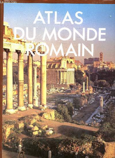
T.Cornell & J.Matthews
Atlas du monde romain.
Editions du Fanal. 1987. In-4. Relié. Bon état, Couv. convenable, Dos satisfaisant, Intérieur frais. 240 pages - jaquette en bon état - nombreuses photos et cartes en couleurs dans et hors texte.. Avec Jaquette. . . Classification Dewey : 912-Atlas, cartes et plans
書籍販売業者の参照番号
: R320144571
|
|
|
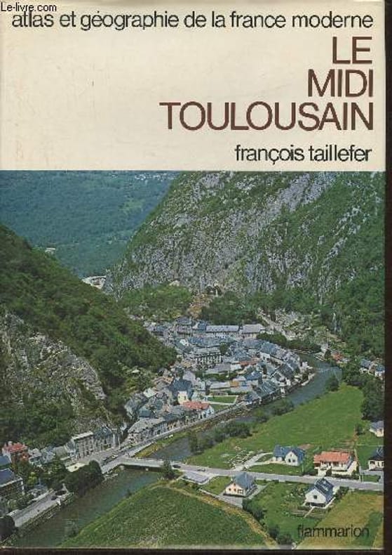
Taillefer François
"Atlas et géographie du Midi Toulousain- Portrait de la France moderne(Collection ""atlas et géographie de la France moderne"")"
Flammarion. 1978. In-4. Relié. Bon état, Coins frottés, Dos satisfaisant, Papier jauni. 314 pages. Quelques rousseurs. Nombreuses photos et cartes en noir et blanc et en couleurs, in et hors texte. Jaquette correcte. Signet conservé.. Avec Jaquette. . . Classification Dewey : 912-Atlas, cartes et plans
書籍販売業者の参照番号
: RO30374545
|
|
|
TAILLEFER ( François )
Atlas et Géographie de la France moderne Le Midi Toulousain
1978 Paris, Flammarion, 1978, in huit,314 pp, reliure d'éditeur avec jaquette illustrée,
書籍販売業者の参照番号
: 62687
|
|
|
Taillefer (François)
Le Midi Toulousain.
Paris Flammarion 1978 Atlas et géographie de la France moderne. Un volume in-4 relié plein simili brun de l'éditeur sous jaquette illustrée, 314 pages. Bel état.
書籍販売業者の参照番号
: 1953
|
|
|
TALBOT
Carte Routière Nord et Sud.
CHEZ L'AUTEUR. 1980. In-8. Broché. Bon état, Couv. défraîchie, Dos satisfaisant, Intérieur acceptable. Carte dépliante en couleurs, de 106 / 50 (recto / verso). Echelle 1 / 1000000. . . . Classification Dewey : 912-Atlas, cartes et plans
書籍販売業者の参照番号
: RO80135337
|
|
|
Talbert, Richard J. A. (Ed. )
BARRINGTON ATLAS OF THE GREEK AND ROMAN WORLD
Includes CD. Very faint edgewear to DJ along top edge. Else fine. ; In 102 full-color maps spread over 175 pages, the Barrington Atlas re-creates the entire world of the Greeks and Romans from the British Isles to the Indian subcontinent and deep into North Africa. It spans the territory of more than 75 modern countries. Its large format (13 1/4 x 18 in. Or 33.7 x 46.4 cm) has been custom-designed by the leading cartographic supplier and is unrivaled for range, clarity, and detail. Over 70 experts, aided by an equal number of consultants, have worked from satellite-generated aeronautical charts to return the modern landscape to its ancient appearance, and to mark ancient names and features in accordance with the most up-to-date historical scholarship and archaeological discoveries. Chronologically, the Barrington Atlas spans archaic Greece to the Late Roman Empire, and no more than two standard scales (1: 500,000 and 1: 1,000,000) are used to represent most regions. Since the 1870s, all attempts to map the classical world comprehensively have failed. The Barrington Atlas has finally achieved that elusive and challenging goal. It began in 1988 at the University of North Carolina, Chapel Hill, under the direction of the distinguished ancient historian Richard Talbert, and has been developed with approximately $4.5 million in funding support. The resulting Barrington Atlas is a reference work of permanent value. It has an exceptionally broad appeal to everyone worldwide with an interest in the ancient Greeks and Romans, the lands they penetrated, and the peoples and cultures they encountered in Europe, North Africa, and Western Asia. Scholars and libraries should find it essential. It is also for students, travelers, lovers of fine cartography, and anyone eager to retrace Alexander's eastward marches, cross the Alps with Hannibal, traverse the Eastern Mediterranean with St. Paul, or ponder the roads, aqueducts, and defense works of the Roman Empire. For the new millennium the Barrington Atlas brings the ancient past back to life in an unforgettably vivid and inspiring way. ; Elephant Folio 23" tall; 272 pages; Overseas Shipping will be charged extra shipping fees.
|
|
|
TARIDE
1 CARTE DEPLIANTE COULEURS : CARTE DE FRANCE DEPARTEMENT ET CHEMINS DE FER, BELGIQUE, BORDS DU RHIN, SUISSE ETC
IMP. CHARAIRE. non daté. In-Plano. En feuillets. Bon état, Couv. convenable, Dos satisfaisant, Intérieur frais. 1 carte en couleurs dépliante de 104 x 90 cm. Echelle 1/12650000.. . . . Classification Dewey : 912-Atlas, cartes et plans
書籍販売業者の参照番号
: RO30081937
|
|
|
TARIDE A.
1 CARTE TARIDE N°3 - CARTE ROUTIERE POUR AUTOMOBILISTE ET CYCLISTES - ENVIRONS DE PARIS - SECTION NORD-EST / ECHELLE 1 - 250 000 KM
TARIDE A.. NON DATE. In-Plano. Broché. Etat d'usage, Couv. convenable, Dos satisfaisant, Intérieur frais. 1 carte en couleur toilée de dimension: 92 x 70 cm environs. . . . Classification Dewey : 912-Atlas, cartes et plans
書籍販売業者の参照番号
: RO20172673
|
|
|
TARIDE
1 CARTE TARIDE - ROUTIER N°11 - BOURGOGNE, MORVAN, NIVERNAIS - ECHELLE 1: 250 000e
TARIDE. NON DATE. In-Plano. En feuillets. Bon état, Couv. convenable, Dos satisfaisant, Intérieur frais. 1 carte depliante en couleur de dimension: 93 x 74 cm environs - ECHELLE 1: 250 000e. . . . Classification Dewey : 912-Atlas, cartes et plans
書籍販売業者の参照番号
: RO20188209
|
|
|
TARIDE
1 CARTE TARIDE - ROUTIER N°14 - LYONNAIS, SAVOIE, DAUPHINE - ECHELLE 1: 250 000e
TARIDE. NON DATE. In-Plano. En feuillets. Bon état, Couv. convenable, Dos satisfaisant, Intérieur frais. 1 carte depliante en couleur de dimension: 93 x 74 cm environs - ECHELLE 1: 250 000e. . . . Classification Dewey : 912-Atlas, cartes et plans
書籍販売業者の参照番号
: RO20188210
|
|
|
TARIDE
1 CARTE TARIDE - ROUTIER N°14 Bis - DAUPHINE, SAVOIE - ECHELLE 1: 250 000e
TARIDE. NON DATE. In-Plano. En feuillets. Bon état, Couv. convenable, Dos satisfaisant, Intérieur frais. 1 carte depliante en couleur de dimension: 91 x 71 cm environs - ECHELLE 1: 250 000e. . . . Classification Dewey : 912-Atlas, cartes et plans
書籍販売業者の参照番号
: RO20188211
|
|
|
TARDIEU AMBROISE- VUILLEMIN A.- LAVALLEE M.B.
ATLAS UNIVERSEL DE GEOGRAPHIE ANCIENNE ET MODERNE- Pour l'intelligence de la géographie universelle de Malte- Brun Lavallée - Géographie de la Bible- Plan de Paris- Chemins de fer de l'Europe...
FURNE JOUVET ET CIE. NON DATE. In-Plano. Relié. Etat d'usage, Couv. défraîchie, Dos satisfaisant, Intérieur frais. 50 planches environ, dépliantes en couleurs ou en noir et blanc- 2 photos disponibles. . . . Classification Dewey : 912-Atlas, cartes et plans
書籍販売業者の参照番号
: R200057069
|
|
|
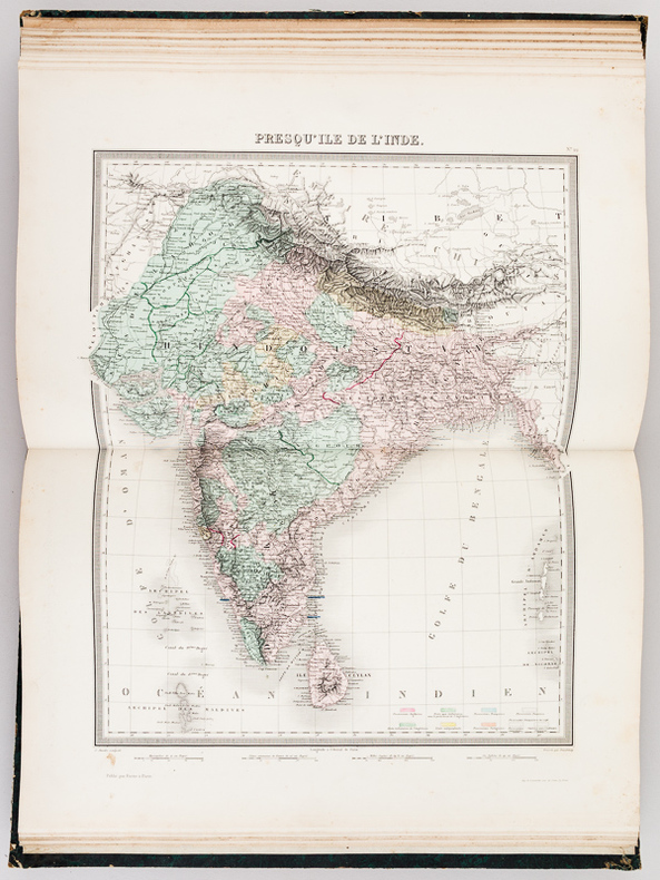
TARDIEU, Ambroise ; VUILLEMIN, A.
Atlas Universel de Géographie ancienne et moderne
Dressé par Ambroise Tardieu, revu et corrigé par A. Vuillemin, pour l'intelligence de la Géographie Universeklle de Malte-Brun Lavallée, 1 vol. in-folio reliure éditeur demi-percaline verte, Furne, Jouvet et Cie, Editeurs, Jouvet et Cie, Successeurs, Paris, 1880, avec 31 cartes : 1 : Empire Romain ; 2 : Empire d'Alexandre ; 3 : Géographie de la Bible ; 4 : Les Gaules ; 5 : Italie ancienne ; 6 : Grèce ancienne ; 7 : Espagne ancienne ; 8 : Mappemonde ; 9 : Europe ; 10 : France au Moyen-Age ; 11 : France par province ; 12 : France par départements ; 13 : Iles Britanniques ; 14 : Allemagne ou Europe Centrale ; 15 : Russie d'Europe ; 16 : Belgique et Hollande ; 17 : Suède et Danemark ; 18 : Espagne et Portugal ; 19 : Italie ; 20 : Turquie d'Europe et Grèce ; 21 : Asie ; 22 : Presqu'Ile de l'Inde ; 23 : Afrique ; 24 : Amérique Septentrionale ; 25 : Etats-Unis et Mexique ; 26 : Amérique Méridionale ; 27 : Océanie ; 28 : Algérie ; 29 : Environs de Paris ; 30 : Plan de Paris avec ses Fortifications ; 31 : Chemins de fer de l'Europe
書籍販売業者の参照番号
: 58312
|
|
|
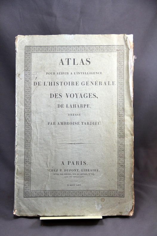
TARDIEU Ambroise:
Atlas pour servir à l'intelligence de l'Histoire générale des voyages de Laharpe, dressé par Ambroise Tardieu.
Paris, P. Dupont, 1825. In-folio broché de [4]p. et 15 cartes dépliantes, couverture grise d'éditeur. Non rogné.
書籍販売業者の参照番号
: 6181
|
|
|
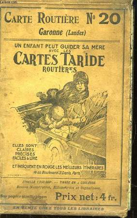
TARIDE
Cartes Taride routières. N°20 : Garonne (Landes)
TARIDE A.. Non daté. In-Plano. En feuillets. Etat d'usage, Couv. légèrement passée, Dos satisfaisant, Pliures. Carte dépliante en couleurs de 116 / 72 cm. Quelques petites déchirures sur les pliures.. . . . Classification Dewey : 912-Atlas, cartes et plans
書籍販売業者の参照番号
: RO80072536
|
|
|
TARIDE
CARTE ROUTIERE N°8 - PARIS ORLEANAIS.
TARIDE. Non daté. In-Plano. Broché. Bon état, Couv. convenable, Dos satisfaisant, Intérieur frais. 1 carte géographique couleur dans pochette.. . . . Classification Dewey : 912-Atlas, cartes et plans
書籍販売業者の参照番号
: R320000721
|
|
 検索結果のメールを受信する
 PDFファイルの検索結果をダウンロード
 RSSフィード


