|
THIERS, Adolphe (1797-1877):
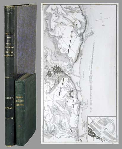
Histoire du Consulat et de l'Empire faisant suite à l'histoire de la Révolution française. 20 tomes + Atlas de l'histoire du Consulat et de l'Empire, dressé et dessiné sous la direction de M. Thiers par MM. Dufour et Duvotenay, gravé sur acier par Dyonnet. Ensemble 21 volumes.
Paris, Paulin-Lheureux, 1845-62, atlas (1866), in-8vo, atlas in-folio, chaque volume env. 500 p., l'atlas comprend 66 cartes dont 7 sur double-page montées sur onglets (deux coloriées), non paginé, toutes les cartes en excellent état + 2 cartes ajoutées: une carte du Nord de l'Italie pour l'étude de la campagne de Napoléon III en1859 par le colonel Suisse F. Lecomte et une carte en fac-similé de la ville de Paris en 1576, reliures en pleine percaline verte, dos et plats estampés de filets à froid, quelques frottements et usures. Atlas in-folio relié en demi-chagrin, dos à nerfs orné de filets dorés, Généralement bel ensemble.
書籍販売業者の参照番号
: 71051aaf
|
|
|
THIERS, Adolphe ; DUFOUR ; DUVOTENAY
Atlas des Campagnes de la Révolution Française
1 vol. in-4 reliure de l'époque demi-basane marron, Librairie Furne, Jouvet & Cie, Paris, s.d. [ circa 1880 ], avec 32 cartes sur onglet
書籍販売業者の参照番号
: 64760
|
|
|
THIERS, Adolphe ; DUFOUR, A. ; DUVOTENAY
Atlas de l'Histoire du Consulat et de l'Empire dressé et dessiné sous la direction de M. Thiers par MM. A. Dufour et Duvotenay
Gravé en relief par M. Gillot, inventeur de la paniconographie, 1 vol in-4 reliure uniforme demi-basane marron, Lheureux et Cie, Paris, 1866, avec 66 cartes à double page (dont 2 en couleurs).
書籍販売業者の参照番号
: 64759
|
|
|
THIERS, Adolphe ; DUFOUR, A. ; DUVOTENAY
Atlas de l'Histoire du Consulat et de l'Empire dressé et dessiné sous la direction de M. Thiers par MM. A. Dufour et Duvotenay
Gravé sur acier par Dyonnet, 1 vol. grand in-4 reliure uniforme demi-veau noir, Lheureux et Cie, Paris, 1859, avec 66 cartes à double page (dont 2 en couleurs).
書籍販売業者の参照番号
: 66577

|
|
|
THIERS, M.A.:
Histoire du consulat et de l'Empire faisant suite a l'histoire de la Révolution Française. En 20 volumes.
Paris, Paulin, 1845 - 1862, in-8vo, avec le portrait de Napoleon (1815) dans le t. 20, rousseurs, cachet de bibl. sur faux titre, brochures originales.
書籍販売業者の参照番号
: 57491aaf
|
|
|
Thom, Ernst
Pharus Städte- Atlas enthaltend die Pharus-Pläne Berlin/Potsdam/Bremen/Breslau/Cassel/Cöln am Rhein/Dresden/Düsseldorf, Frankfurt am Main/Hamburg/Hannover/Kiel/Königsberg/Leipzig/Magdeburg/München/Nürnberg/Stettin/Stuttgart/Wiesbaden. Verkehrsausgabe 1905/06
Berlin, Pharus-Varlag, 1905/06. 2°, 20 doppelblattgroße Karten, 194 S., LVI S; goldgepr. OHLn
書籍販売業者の参照番号
: 7-10-678

|
|
|
Thom, Ernst
Pharus-Atlas Deutscher Städte. Mit illustrierten Bäder-Anzeigen, Führer, Hotel-Register etc. und einem Anhang der Stadtpläne von Brüssel, London, Paris und Wien, Sonderanhang Schweiz und Mitglieder-Verzeichnis des Interantionalen Möbel-Transport-Verbandes
Hamburg, Deutsche Verlags-Gesellschaft, Ausgabe 1912/17. 2°, 24 doppelblattgroße Karten, 261, LVI S; goldgepr. OHLn
書籍販売業者の参照番号
: 7-10-421

|
|
|
Thomas (de Tours) Docteur
Eléments d'otéologie descriptive et comparée de l'homme et des animaux domestiques. Atlas de 12 planches
1865 Paris Delahaye 1865
書籍販売業者の参照番号
: 7829
|
|
|
Thomas, Oswald
Atlas der Sternbilder mit figuralen Darstellungen von Richard Teschner.
Salzburg, Bergland-Buch, 1945. 154 S., 1 Bl. mit 90 ganzseit. Abb. OHLwd. (etw. bestoßen und gebräunt).
書籍販売業者の参照番号
: 17616
|
|
|
THOMAS, Oswald
Atlas der Sternbilder. Mit figuralen Darstellungen von Richard Teschner. + 1 Beigabe.
Salzburg, "Das Bergland-Buch" 1945. quer-4°, 154(1) S., mit 90 Taf., OHln., Kanten berieben. - Beiliegend: "Carte du ciel. Dressée par l'Institut Geographique National pour le 1er Janvier 1980. Ca 72 x 74 cm, rot u. schwarz gedruckt. Beigabe: Thomas, Oswald: Astronomie. Tatsachen und Probleme. Salzburg, Das Bergland-Buch 1942. OLn.
書籍販売業者の参照番号
: NATW0150a
|
|
|
Thompson Sanford E. Sanford Eleazer Atlas Portland Cement Company
Reinforced concrete in factory construction 1907 Leather Bound
2019. Leather Bound. New. Leather Binding on Spine and Corners with Golden Leaf Printing on round Spine. Reprinted in 2019 with the help of original edition published long back 1907. This book is printed in black & white sewing binding for longer life Printed on high quality Paper re-sized as per Current standards professionally processed without changing its contents. As these are old books we processed each page manually and make them readable but in some cases some pages which are blur or missing or black spots. If it is multi volume set then it is only single volume if you wish to order a specific or all the volumes you may contact us. We expect that you will understand our compulsion in these books. We found this book important for the readers who want to know more about our old treasure so we brought it back to the shelves. Hope you will like it and give your comments and suggestions. Lang: - eng Pages 262. EXTRA 10 DAYS APART FROM THE NORMAL SHIPPING PERIOD WILL BE REQUIRED FOR LEATHER BOUND BOOKS. FOLIO EDITION IS ALSO AVAILABLE. hardcover
書籍販売業者の参照番号
: LB1111005210657
|
|
|
Thompson Sanford E. Sanford Eleazer Atlas Portland Cement Company
Reinforced concrete in factory construction 1907 Hardcover
2020. Hardcover. New. Lang: - eng Pages 262. Reprinted in 2020 with the help of original edition published long back 1907. This book is Printed in black & white Hardcover sewing binding for longer life with Matt laminated multi-Colour Dust Cover Printed on high quality Paper re-sized as per Current standards professionally processed without changing its contents. As these are old books we processed each page manually and make them readable but in some cases some pages which are blur or missing or black spots. If it is multi volume set then it is only single volume if you wish to order a specific or all the volumes you may contact us. We expect that you will understand our compulsion in these books. We found this book important for the readers who want to know more about our old treasure so we brought it back to the shelves. Any type of Customisation is possible with extra charges. Hope you will like it and give your comments and suggestions. hardcover
書籍販売業者の参照番号
: 1111005210657
|
|
|
Thompson Sanford E. Sanford Eleazer Atlas Portland Cement Company
Reinforced concrete in factory construction 1907
2020. Paperback. New. Lang: - eng Pages 262. Reprinted in 2020 with the help of original edition published long back 1907. This book is Printed in black & white sewing binding for longer life with Matt laminated multi-Colour Soft Cover HARDCOVER EDITION IS ALSO AVAILABLE Printed on high quality Paper re-sized as per Current standards professionally processed without changing its contents. As these are old books we processed each page manually and make them readable but in some cases some pages which are blur or missing or black spots. If it is multi volume set then it is only single volume if you wish to order a specific or all the volumes you may contact us. We expect that you will understand our compulsion in these books. We found this book important for the readers who want to know more about our old treasure so we brought it back to the shelves. Any type of Customisation is possible with extra charges. Hope you will like it and give your comments and suggestions. paperback
書籍販売業者の参照番号
: PB1111005210657
|
|
|
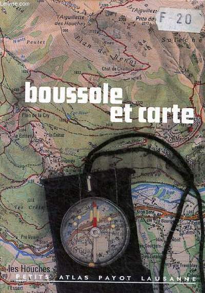
THONE KARL ET KAUFMANN EDWIN
BOUSSOLE ET CARTE
PAYOT LAUSANNE. NON DATE. In-12. Broché. Bon état, Couv. convenable, Dos satisfaisant, Intérieur frais. 74 pages - Nombreuses illustrations en noir et blanc et couleurs dans et hors texte. . . . Classification Dewey : 912-Atlas, cartes et plans
書籍販売業者の参照番号
: R320079320
|
|
|
THOREZ Paul
MOSCOU.
reliure éditeur - 17,5x27 - 215 pp - 1964 - éditions RENCONTRE, Lausanne.Collection " ATLAS DES VOYAGES, RENCONTRE" dirigée par Charles-Henri FAVROD.Nombreuses illustrations dans et hors texte.
書籍販売業者の参照番号
: 4950
|
|
|
THUILIER - HACQ
1 CARTE ENTOILEE DE PERIGEUX
DEPOT DE LA GUERRE. 1909. In-Folio. Broché. Bon état, Couv. convenable, Dos satisfaisant, Intérieur frais. 1 carte entoilée de 86 x 58,5 cm, dépliante, en noir et blanc. Echelle 1/80000.. . . . Classification Dewey : 912-Atlas, cartes et plans
書籍販売業者の参照番号
: RO30079598
|
|
|
THUILLIER / COUSTEIX / LECOCQ
Carte du S.E De Luz.
INSTITUT GEOGRAPHIQUE NATIONAL. Non daté. In-Plano. En feuillets. Bon état, Couv. convenable, Dos satisfaisant, Intérieur frais. Carte dépliante en noir et blanc, hors-texte, de 70/55 cm. Pas de plats de couverture. Tampon.. . . A l'italienne. Classification Dewey : 912-Atlas, cartes et plans
書籍販売業者の参照番号
: RO80017183
|
|
|
THUILLIER / HACQ / GODART
Carte de Avallon
DEPOT DE GUERRE. Fin XIXème. In-Plano. En feuillets. Bon état, Couv. convenable, Dos satisfaisant, Intérieur frais. Carte dépliante de 88/62 cm, en noir et blanc. Pas de plats de couverture.. . . . Classification Dewey : 912-Atlas, cartes et plans
書籍販売業者の参照番号
: RO80009148
|
|
|
THUILLIER / BLANCHARD / GERIN / BEAUPRE
Carte d'Agen. N°205
DEPOT DE LA GUERRE. 1884. In-Plano. Cartonnage d'éditeurs. Bon état, Livré sans Couverture, Dos satisfaisant, Intérieur acceptable. Carte dépliante entoilée, en noir et blanc, hors-texte, de 90 / 60 cm. Quelques parties brunies.. . . . Classification Dewey : 912-Atlas, cartes et plans
書籍販売業者の参照番号
: RO80053017
|
|
|
THUILLIER / HACQ / BLONDEAU
Carte de Meaux
DEPOT DE GUERRE. 1832. In-Plano. En feuillets. Etat d'usage, Couv. convenable, Dos satisfaisant, Intérieur bon état. Carte dépliante bicolore, de 60/90 cm. Pas de plat de couverture. Quelques déchirures.. . . A l'italienne. Classification Dewey : 912-Atlas, cartes et plans
書籍販売業者の参照番号
: RO20054740
|
|
|
THUILLIER / HACQ / HENNEQUIN
Carte de Maubeuge (Sud-Oeust / Sud-Est)
DEPOT DE GUERRE. 1913. In-Plano. En feuillets. Bon état, Couv. convenable, Dos satisfaisant, Intérieur frais. Carte dépliante en noir et blanc, de 32/90 cm. Pas de plat de couverture.. . . A l'italienne. Classification Dewey : 912-Atlas, cartes et plans
書籍販売業者の参照番号
: RO20054744
|
|
|
THUILLIER / HACQ / HENNEQUIN
Carte de Meaux N°49
DEPOT DE GUERRE. 1912. In-Plano. En feuillets. Bon état, Couv. convenable, Dos satisfaisant, Intérieur frais. Carte dépliante en noir et blanc, de 85/59cm. Pas de plats de couverture.. . . . Classification Dewey : 912-Atlas, cartes et plans
書籍販売業者の参照番号
: RO80006326
|
|
|
THUILLIER / HACQ / LEROY / ROUILLARD
Carte de Lure
DEPOT DE GUERRE. 1913. In-Plano. En feuillets. Bon état, Couv. convenable, Dos satisfaisant, Intérieur bon état. Carte dépliante en noir et blanc, de 64/88 cm. Pas de plat de couverture.. . . A l'italienne. Classification Dewey : 912-Atlas, cartes et plans
書籍販売業者の参照番号
: RO20054742
|
|
|
THUILLIER / HACQ / ORGIAZZI
Carte de Wassy.
DEPOT DE GUERRE. 1913. In-Plano. En feuillets. Bon état, Couv. convenable, Dos satisfaisant, Intérieur bon état. Carte dépliante en noir et blanc de 84/59 cm. Pas de plats de couverture. Pliures.. . . . Classification Dewey : 912-Atlas, cartes et plans
書籍販売業者の参照番号
: RO20040370
|
|
|
THUILLIER / HACQ / ORQIAZZI / ROUILLARD
Carte de Bourg, Sud-Est.
SERVICE GEOGRAPHIQUE DE L'ARMEE. 1889. In-Plano. En feuillets. Bon état, Couv. convenable, Dos satisfaisant, Intérieur bon état. Carte dépliante en noir et blanc, de 52/72 cm. Pas de plat de couverture.. . . A l'italienne. Classification Dewey : 912-Atlas, cartes et plans
書籍販売業者の参照番号
: RO20054699
|
|
|
THUILLIER et HACQ
Carte de Wassy . N° 68
DEPOT DE LA GUERRE. 1913. In-Plano. En feuillets. Bon état, Livré sans Couverture, Dos satisfaisant, Intérieur acceptable. Carte dépliante en noir et blanc de 59 / 84 cm. . . A l'italienne. Classification Dewey : 912-Atlas, cartes et plans
書籍販売業者の参照番号
: RO80072069
|
|
|
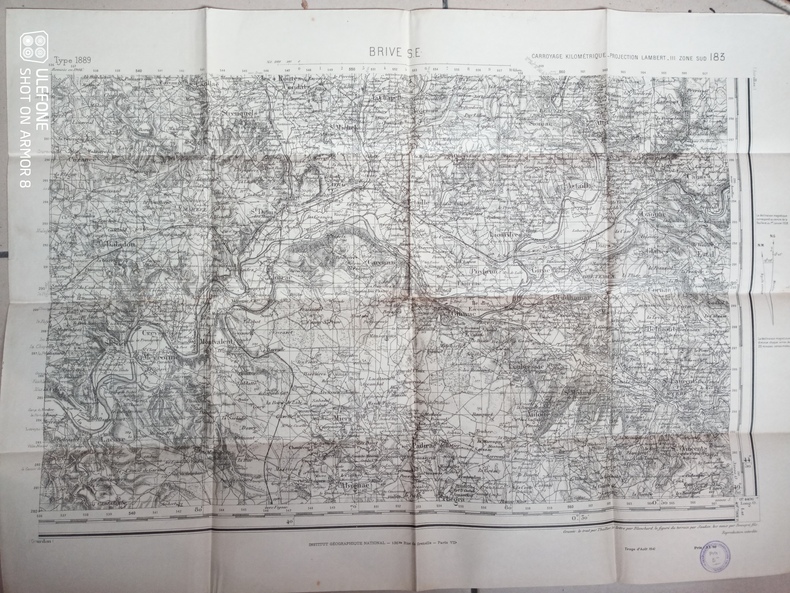
Thuillier, Blanchard, Soudan, Beaupré fils
Carte d'Etat-Major de Brive S.E. - Carroyage kilométrique, projection Lambert III, zone sud
Institut National Géographique. 1941. In-Plano. En feuillets. Bon état, Couv. convenable, Dos satisfaisant, Intérieur frais. Une carte en noir et blanc. Environ 54 x 74 cm. Tampon du Secrétariat d'Etat aux communications.. . . . Classification Dewey : 912-Atlas, cartes et plans
書籍販売業者の参照番号
: RO80240271
|
|
|
THUILLIER, HACQ et HENNEQUIN
Carte de Maubeuge, Sud-Ouest et Sud-Est. N°9
DEPOT DE LA GUERRE. 1913. In-Folio. En feuillets. Bon état, Livré sans Couverture, Dos satisfaisant, Intérieur frais. Carte dépliante en noir et blanc de 30 / 84 cm.. . . A l'italienne. Classification Dewey : 912-Atlas, cartes et plans
書籍販売業者の参照番号
: RO80072063
|
|
|
THUILLIER, HACQ et HENNEQUIN
Carte entoilée de Maubeuge, Feuille N°9
DEPOT DE LA GUERRE. 1832. In-12. En feuillets. Très bon état, Livré sans Couverture, Dos satisfaisant, Intérieur frais. Carte dépliante entoilée, en noir et blanc, de 58 x 87 cm. Echelle 1 / 80000. . . A l'italienne. Classification Dewey : 912-Atlas, cartes et plans
書籍販売業者の参照番号
: RO80119640
|
|
|
THUILLIER, HACQ et KARDL
Carte de Douai. N°8
DEPOT DE LA GUERRE. 1914. In-Plano. En feuillets. Bon état, Livré sans Couverture, Dos satisfaisant, Intérieur acceptable. Carte dépliante en noir et blanc de 59 / 84 cm. . . A l'italienne. Classification Dewey : 912-Atlas, cartes et plans
書籍販売業者の参照番号
: RO80072072
|
|
|
THUILLIER, HACQ et Orgiazzi
Carte entoilée de Vassy, Feuille n°68
DEPOT DE LA GUERRE. 1874. In-12. En feuillets. Bon état, Livré sans Couverture, Dos satisfaisant, Intérieur frais. Carte dépliante entoilée, en noir et blanc, de 59 x 86 cm. Echelle 1 / 80000. . . A l'italienne. Classification Dewey : 912-Atlas, cartes et plans
書籍販売業者の参照番号
: RO80119646
|
|
|
Thöne Karle teKaufmann Edwin
Boussole et carte N°73
Payot. non daté. In-18. Relié. Bon état, Couv. convenable, Dos satisfaisant, Intérieur frais. 74 pages augmentées de quelques photos en noir et blanc dans texte.. . . . Classification Dewey : 912-Atlas, cartes et plans
書籍販売業者の参照番号
: R260264584
|
|
|
TILMONT J., de ROECK M., LAMBION J., DEBULPAEP C.
Atlas.
Bruxelles, De Boeck-Wesmael, 1986. 25 x 35, 170 pp., très nombreuses cartes en couleurs, reliure d'édition carton imprimé, très bon état.
書籍販売業者の参照番号
: 89586
|
|
|
TILMONT, J. - DE ROECK, M.
Cours de Geographie, Tome I : Geographie Générale.
Maison d'Édition Ad. Wesmael Charlier ("Collection Roland"), 1952. in-8°, 341 pages + 107 illustrations, broché.
書籍販売業者の参照番号
: 80500
|
|
|
TILMONT, J. - DE ROECK, M.
Cours de Geographie, Tome I : Geographie Générale.
in-8°, 341 pages + 107 illustrations, broché. Excellent etat. [SO-1]
|
|
|
Time-Life Books (Editors).
ARMS, EQUIPMENT AND ATLAS OF THE CIVIL WAR. Three Volumes. (ILLUSTRATED ATLAS OF THE CIVIL WAR; ARMS AND EQUIPMENT OF THE UNION; ARMS, EQUIPMENT OF THE CONFEDERACY).
Three Volumes. Profusely illustrated with maps, photographs and drawings, many in color. 4to. Original pictorial wraps. Original pictorial box. Very nice set. CW W19 **PRICE JUST REDUCED!
|
|
|
TIMES ATLAS.
JAPAN.
London 1895 Times. A single sheet map colored very good with insets: LiuKiu Yezo Nambu & Tsubu 9 x 14.25 inches. A highly framable work showing detail of topography all of Japan's islands with a small portion of Korea and Siberia. . unknown
書籍販売業者の参照番号
: 90047401
|
|
|
Times" Concise Atlas of the World No author stated stated
Times" Concise Atlas of the World No author
Very Good. 1987 Fifth edition revised. Very good condition. Shelf wear to edges of slip case. Weight >2kg so will be sent using courier. Same day dispatch Mon-Fri from the UK if ordered by 1pm. unknown
書籍販売業者の参照番号
: C5T-VJ2-3MF ISBN : 0723002789 9780723002789
|
|
|
Timm, Stefan
Christliche Stätten in Ägypten. Von Stefan Timm. (= Tübinger Atlas des Vorderen Orients, Nr. 36). Als Typoskript gedruckt.
Wiesbaden: Reichert 1979. 167 Seiten. Gr. 8° (22,5-25 cm). Orig.-Broschur. [Softcover / Paperback].
書籍販売業者の参照番号
: 87625

|
|
|
TIMMERS J.
Petit atlas de l'art roman.
Bruxelles, Séquoia, 1965 14 x 21, 241 pp., illustrations N/B et cartes, broché, bon état.
書籍販売業者の参照番号
: 7282
|
|
|
Tischendorf, Frank W. und Gerald F. Klostermann
Der diagnostische Blick : Atlas zur Differentialdiagnose innerer Krankheiten. hrsg. von F. W. Tischendorf. Begr. von G. F. Klostermann ... Mit Beitr. von H. Fischer ... 5., neubearb. und stark erw. Aufl.
Stuttgart ; New York : Schattauer 1993. XIV, 458 S. : 845 Abb., davon 822 farb.; 29 cm, Vorsatzblatt verknittert, Pp., gebundene Ausgabe, Hardcover/Pappeinband, Einbandrücken seitlich beschädigt, sonst Exemplar in gutem Erhaltungszustand
書籍販売業者の参照番号
: 65076

|
|
|
TITE-LIVE
Titi Livii Historiarum quod exstat, cum integris Joannis Freinshemii Supplementis...[Titi Livii Historiarum. TOME X. SEUL [INDEX WETSTENIANUS] Geographia Liviana & index rerum locupletissimus]
Amstelaedami H. Wetstenium ; Trajecti ad Rhenum : apud G. Van de Water 1710 in-12 plein-veau un volume, reliure plein veau brun raçiné in-douze (16,3 x 10 cm), RELIURE D'EPOQUE, dos à nerfs (spine with raised bands), décorations "or" et à froid (gilt and blind stamping decoration), titre frappé "or" dans un encadrement d'un filet perlé "or" et tomaison frappée "or"dans un encadrement d'un filet perlé "or" avec rinceaux "or" aux angles, pièce de titre et de tomaison sur fond bordeaux, entre-nerfs à fleurons "or" dans un encadrement d'un filet perlé "or" avec rinceaux "or" aux angles, filet à froid de part et d'autre des nerfs, roullette large "or" en pied, coiffe de tête quasiment manquante avec un léger manque de cuir en tête due moins d'1/3 de cm2, plats décorés à froid, d'un filet à froid en encadrement, roulettes "or" sur les coupes avec manque de dorure, coins écornés, toutes tranches lisses jaspées rouges, orné d'un frontispice de J. Goeree représentant TITE-LIVE gravé sur bois en noir + 14 planches géographiques dépliantes [Geographia Liviana] gravées sur bois en noir in-fine, 363 pages d'Index revu et augmenté par Jean Le Clerc + 14 planches de cartes géographiques dépliantes [Geographia Liviana], 1710 Amstelaedami : apud H. Wetstenium ; Trajecti ad Rhenum : apud G. Van de Water Editeurs,
書籍販売業者の参照番号
: 23945
|
|
|
Title Atlas Company Minneapolis
1979 Atlas of Palo Alto County Iowa: Containing Maps Plats of the Townships Rural Directory Pictures of Farms & Families Articles about History Etc
Title Atlas Company Minneapolis. Very Good. 1979. Paperback. Spiral binding . Title Atlas Company, Minneapolis paperback
書籍販売業者の参照番号
: 902100
|
|
|
Title Atlas Company Minneapolis
1990 Atlas of Dubuque County Iowa: Containing Maps Plats of the Townships Rural Directory Pictures of Farms & Families Articles about History Etc
Title Atlas Company Minneapolis. Very Good. 1990. Paperback. Spiral binding . Title Atlas Company, Minneapolis paperback
書籍販売業者の参照番号
: 902089
|
|
|
Title Atlas Company
Atlas of Valley County Nebraska Containing Maps Plats of the Townships Rural Directory Pictures of Schools Churches Articles on Agriculture Etc.
Title Atlas Co. G. 1964. Spiral bound. Stiff card cover rubbed missing rear cover and top corners of pages creased. Approximately 75 pages. Township maps show landowners directory includes names of spouse and children occupations etc. ; MCN27558; Folio 13" - 23" tall . Title Atlas Co. unknown
書籍販売業者の参照番号
: 33529
|
|
|
Title Atlas Co
Pictorial Atlas of Olmsted County Minnesota
Title Atlas Co 1983. Book. Near Fine. Spiral Bound Paperback. Includes many family photos in rear. Title Atlas Co Paperback
書籍販売業者の参照番号
: 094136
|
|
|
Title Atlas Company
Pictorial Atlas of Pierce County Wisconsin
Tite Atlas Co 1985. Book. Near Fine. Spiral Bound Paperback. Tite Atlas Co Paperback
書籍販売業者の参照番号
: 092081
|
|
|
Title Atlas Co
Pictorial Atlas of Winneshiek County Iowa
Title Atlas Co 1978. Book. Very Good-. Spiral Bound Paperback. Some damp staining to cover and first couple pages. . Title Atlas Co Paperback
書籍販売業者の参照番号
: 091376
|
|
|
Title Atlas Co
Pictorial Atlas of Mower County Minnesota
Title Atlas Co 1983. Book. Very Good-. Spiral Bound Paperback. Some damp staining to bottom corners of first few pges. Title Atlas Co Paperback
書籍販売業者の参照番号
: 091380
|
|
|
Title Atlas Co
Pictorial Atlas of Steele County Minnesota
Title Atlas Co 1970. Book. Very Good-. Spiral Bound Paperback. Some damp staining to edges of first few pages. . Title Atlas Co Paperback
書籍販売業者の参照番号
: 091381
|
|
 検索結果のメールを受信する
 PDFファイルの検索結果をダウンロード
 RSSフィード


