|
Universal Cyclopaedia and Atlas; Adams Charles Kendall Ed.
Universal Cyclopaedia and Atlas Map of the Philippine Islands- Original 1902
D. Appleton and Company 1902. No Binding. Fine. TThis rare original hand colored map of the Philippine Islands is from Volume IX of the 1902 edition the highly acclaimed Universal Cyclopaedia and Atlas . This map depicts a snapshot of the political landscape of the Philippine's at the turn of the 20th century. Includes insert of Manila Bay. Plate size: 9 1/4" x 12 1/2" 23.5 x 31/8 cm; Margins: Additional photos available upon request. All items carefully packed to avoid damage from moisture and rough handling. D. Appleton and Company unknown
Ссылка продавца : 004629

|
|
|
Universal Cyclopaedia and Atlas; Adams Charles Kendall Ed.
Universal Cyclopaedia and Atlas Map of the Klondike Gold Region Canada - Original 1902
D. Appleton and Company 1902. No Binding. Fine. This rare original hand colored map of the Klondike Gold Region Canada is from Volume VI of the 1902 edition of the acclaimed Universal Cyclopaedia and Atlas by D. Appleton and Company. Cities towns roads and rail lines are clearly depicted. Includes insert of the Klondike River and Vicinity. Plate size: - 9 Additional photos available upon request. All items carefully packed to avoid damage from moisture and rough handling. D. Appleton and Company unknown
Ссылка продавца : 004620
|
|
|
Universal Cyclopaedia and Atlas; Adams Charles Kendall Ed.
Universal Cyclopaedia and Atlas Hypsometric Map of the United States- Original 1902
D. Appleton and Company 1902. No Binding. Fine. This rare hand colored Hypsometric Map of the United States is from Volume XII of the 1902 edition the highly acclaimed Universal Cyclopaedia and Atlas.It depicts the elevations of the Lower 48 states and territories. Plate size: 9.25" x 13" 23.5 x 33 cm; Margins: Minimum 1/2" 1.3 cm. Condition: Fine with central fold as issued. Additional photos available upon request. All items carefully packed to avoid damage from moisture and rough handling. D. Appleton and Company unknown
Ссылка продавца : 004636

|
|
|
Universal Cyclopaedia and Atlas; Adams Charles Kendall Ed.
Universal Cyclopaedia and Atlas Map of Idaho Original 1902
D. Appleton and Company 1902. No Binding. Fine. This rare original hand colored map of Idaho is from Volume VI of the 1902 edition of the acclaimed Universal Cyclopaedia and Atlas by D. Appleton and Company. Counties are distinguished by color. Cities towns roads and rail lines are clearly depicted. Plate size: - 9" x 5 1/2 " 23 x 14 cm. Margins: - Min 1/2in 1.2cm. Condition: Fine Additional photos available upon request. All items carefully packed to avoid damage from moisture and rough handling. D. Appleton and Company unknown
Ссылка продавца : 004600

|
|
|
Universal Cyclopaedia and Atlas; Adams Charles Kendall Ed.
Universal Cyclopaedia and Atlas Map of Utah Original 1902
D. Appleton and Company 1902. No Binding. Fine. This rare original hand colored map of Utah is from Volume XII of the 1902 edition of the acclaimed Universal Cyclopaedia and Atlas by D. Appleton and Company. Counties are distinguished by color. Cities towns roads and rail lines are clearly depicted. Plate size: - 9" x 5 1/2 " 23 x 14 cm. Margins: - Min 1/2in 1.2cm. Condition: Fine Additional photos available upon request. All items carefully packed to avoid damage from moisture and rough handling. D. Appleton and Company unknown
Ссылка продавца : 004639

|
|
|
Universal Cyclopaedia and Atlas; Adams Charles Kendall Ed.
Universal Cyclopaedia and Atlas Map of Iowa - Original 1902
D. Appleton and Company 1902. No Binding. Fine. This rare original hand colored map of Iowa is from Volume VI of the 1902 edition of the acclaimed Universal Cyclopaedia and Atlas by D. Appleton and Company. Counties are distinguished by color. Cities towns roads and rail lines are clearly depicted. Plate size: - 6" x 9 " 15 x 23 cm. Margins: - Min 1/2 in 1.2cm. Condition: Fine Additional photos available upon request. All items carefully packed to avoid damage from moisture and rough handling. D. Appleton and Company unknown
Ссылка продавца : 004606

|
|
|
Universal Cyclopaedia and Atlas; Adams Charles Kendall Ed.
Universal Cyclopaedia and Atlas Map of Kansas - Original 1902
D. Appleton and Company 1902. No Binding. Fine. This rare original hand colored map of Iowa is from Volume VI of the 1902 edition of the acclaimed Universal Cyclopaedia and Atlas by D. Appleton and Company. Counties are distinguished by color. Cities towns roads and rail lines are clearly depicted. Plate size: - 8 Additional photos available upon request. All items carefully packed to avoid damage from moisture and rough handling. D. Appleton and Company unknown
Ссылка продавца : 004618

|
|
|
Universal Cyclopaedia and Atlas; Adams Charles Kendall Ed.
Universal Cyclopaedia and Atlas Map of Central America- Original 1902
D. Appleton and Company 1902. No Binding. Fine. This rare original hand colored map of Central America from Volume I of the 1902 edition of the acclaimed Universal Cyclopaedia and Atlas by D. Appleton and Company. This extraordinary example of 19th century map making depicts a snapshot of the political environment of Central America at the turn of the 20th century.Includes location of proposed Panama Canal. Plate size: 10" x 12" 25 x 30 cm ; Margins: - Min 1/2 in 1.2 cm. Condition: Fine; central fold as issued. Additional photos available upon request. All items carefully packed to avoid damage from moisture and rough handling. D. Appleton and Company unknown
Ссылка продавца : 004581

|
|
|
Universal Cyclopaedia and Atlas; Adams Charles Kendall Ed.
Universal Cyclopaedia and Atlas Map of Alaska and Klondike Region - Original 1902
D. Appleton and Company 1902. No Binding. Fine. This rare original hand colored map of the Territory of Alaska and Klondike Region is from Volume I of the 1902 edition of the acclaimed Universal Cyclopaedia and Atlas by D. Appleton and Company. Cities towns roads and rail lines are clearly depicted. Included are insets for the South West Part of the Aleutian Islands and for the South East Part of Alaska. Plate size: - 9 1/4" x 11" 23.5 x 28 cm " . Margins: - Min 1/2in 1.2cm. Condition: Fine; central fold as issued. Additional photos available upon request. All items carefully packed to avoid damage from moisture and rough handling. D. Appleton and Company unknown
Ссылка продавца : 004579

|
|
|
Universal Cyclopaedia and Atlas; Adams Charles Kendall Ed.
Universal Cyclopaedia and Atlas Map of Cuba - Original 1902
D. Appleton and Company 1902. No Binding. Fine. This rare original hand colored map of Cuba is from Volume III of the 1902 edition of the acclaimed Universal Cyclopaedia and Atlas by D. Appleton and Company. Provinces are distinguished by color. Cities towns roads and rail lines are clearly depicted. Inset map of metropolitan Havana Plate size: - 6" x 9 " 15 x 23 cm. Margins: - Min 1/2 in 1.2cm. Condition: Fine Additional photos available upon request. All items carefully packed to avoid damage from moisture and rough handling. D. Appleton and Company unknown
Ссылка продавца : 004593

|
|
|
Universal Cyclopaedia and Atlas; Adams Charles Kendall Ed.
Universal Cyclopaedia and Atlas Map of Chicago Illinois - Original 1902
D. Appleton and Company 1902. No Binding. Fine. This rare original hand colored map of the the City of Chicago Illinois is from Volume II of the 1902 edition of the acclaimed Universal Cyclopaedia and Atlas by D. Appleton and Company. Streets public buildings colleges hospitals rail depots rail lines hotels theatres and churches are clearly identified. Plate size: - 9" x 12" 23 x 30 cm; Margins: - Min 1/4 in 0.6cm. Condition: Fine; Central fold as issued. Pictures of the Fine Arts Building World's Columbian Exposition and the University of Chicago principal building on the obverse sides. Additional photos available upon request. All items carefully packed to avoid damage from moisture and rough handling. D. Appleton and Company unknown
Ссылка продавца : 004572

|
|
|
Universal Cyclopaedia and Atlas; Adams Charles Kendall Ed.
Universal Cyclopaedia and Atlas Map of Washington D. C. - Original 1902
D. Appleton and Company 1902. No Binding. Fine. This rare original colored map of the city of Washington D.C. is from Volume XII of the 1902 edition of the acclaimed Universal Cyclopaedia and Atlas. Streets public buildings colleges hospitals rail depots rail lines hotels theatres and churches are clearly identified. Plate size: 9" x 12" 23 x 30 cm; Min Additional photos available upon request. All items carefully packed to avoid damage from moisture and rough handling. D. Appleton and Company unknown
Ссылка продавца : 004644

|
|
|
Universal Cyclopaedia and Atlas; Adams Charles Kendall Ed.
Universal Cyclopaedia and Atlas Map of Peking in 1900- Original 1902
D. Appleton and Company 1902. No Binding. Fine. This rare original colored map of Peking China showing points of interest and routes taken by the Allied Armies on Entering the City for the Relief of the Besieged Legations is from Volume IX of the 1902 edition of the acclaimed Universal Cyclopaedia and Atlas. . Plate size: 5 1/2" x 5 Additional photos available upon request. All items carefully packed to avoid damage from moisture and rough handling. D. Appleton and Company unknown
Ссылка продавца : 004624

|
|
|
Universal Cyclopaedia and Atlas; Adams Charles Kendall Ed.
Universal Cyclopaedia and Atlas Map of Paris- Original 1902
D. Appleton and Company 1902. No Binding. Fine. This rare original colored map of Paris France is from Volume IX of the 1902 edition of the acclaimed Universal Cyclopaedia and Atlas. Streets public buildings colleges hospitals rail depots rail lines hotels theatres and churches are clearly identified. Plate size: 9" x 12 Additional photos available upon request. All items carefully packed to avoid damage from moisture and rough handling. D. Appleton and Company unknown
Ссылка продавца : 004623

|
|
|
Universal Cyclopaedia and Atlas; Adams Charles Kendall Ed.
Universal Cyclopaedia and Atlas Map of China - Original 1902
D. Appleton and Company 1902. No Binding. Fine. This rare original hand colored map of China is from Volume II of the 1902 edition of the acclaimed Universal Cyclopaedia and Atlas by D. Appleton and Company. Plate size: 9 1/4" x 11 1/4"- Margins: Min 1/2in. Condition: Fine; central fold as issued. Additional photos available upon request. All items carefully packed to avoid damage from moisture and rough handling. D. Appleton and Company unknown
Ссылка продавца : 004573

|
|
|
Universal Cyclopaedia and Atlas; Adams Charles Kendall Ed.
Universal Cyclopaedia and Atlas Map of the West Indies and Central America - Original 1902
D. Appleton and Company 1902. No Binding. Fine. This rare original hand colored map of the West Indies and Central America is from Volume XII of the 1902 edition of the acclaimed Universal Cyclopaedia and Atlas Cities towns roads rail lines and geographical features are clearly depicted. . Plate size: - 9" x 12" 23 x 30.5 cm; Margins: - Min 1/2 in 12.7 mm. Fine;light age toning along margin; central fold as issued. Additional photos available upon request. All items carefully packed to avoid damage from moisture and rough handling. D. Appleton and Company unknown
Ссылка продавца : 004645

|
|
|
Universal Cyclopaedia and Atlas; Adams Charles Kendall Ed.
Universal Cyclopaedia and Atlas Map of Connecticut - Original 1902
D. Appleton and Company 1902. No Binding. Fine. This rare original hand colored map of Connecticut is from Volume IiI of the 1902 edition of the acclaimed Universal Cyclopaedia and Atlas by D. Appleton and Company. Counties are distinguished by color. Cities towns roads and rail lines are clearly depicted. Plate size: - 6" x 9 " 15 x 23 cm. Margins: - Min 1/2 in 1.2cm. Condition: Fine Additional photos available upon request. All items carefully packed to avoid damage from moisture and rough handling. D. Appleton and Company unknown
Ссылка продавца : 004592

|
|
|
Universal Cyclopaedia and Atlas; Adams Charles Kendall Ed.
Universal Cyclopaedia and Atlas Map of Kentucky - Original 1902
D. Appleton and Company 1902. No Binding. Fine. This rare original hand colored map of Kentucky is from Volume VI of the 1902 edition of the acclaimed Universal Cyclopaedia and Atlas by D. Appleton and Company. Counties are distinguished by color. Cities towns roads and rail lines are clearly depicted. Plate size: - 5 Additional photos available upon request. All items carefully packed to avoid damage from moisture and rough handling. D. Appleton and Company unknown
Ссылка продавца : 004619

|
|
|
Universal Cyclopaedia and Atlas; Adams Charles Kendall Ed.
Universal Cyclopaedia and Atlas Map of New Brunswick and Quebec of the Dominion of Canada- Original 1902
D. Appleton and Company 1902. No Binding. Fine. TThis rare original hand colored copper plate engraved map of New Brunswick and Quebec of the Dominion of Canada is from Volume IX of the 1902 edition the highly acclaimed Universal Cyclopaedia and Atlas . This map depicts a snapshot of the political landscape of New Brunswick and Quebec at the dawn of the 20th Century. Plate size: - 6" x 9 " 15 x 23 cm; Margins: - Min 1/2in 1.2 cm. Condition: Fine. Additional photos available upon request. All items carefully packed to avoid damage from moisture and rough handling. D. Appleton and Company unknown
Ссылка продавца : 004631

|
|
|
Universal Cyclopaedia and Atlas; Adams Charles Kendall Ed.
Universal Cyclopaedia and Atlas Map of Illinois Original 1902
D. Appleton and Company 1902. No Binding. Fine. This rare original hand colored map of Illinois is from Volume VI of the 1902 edition of the acclaimed Universal Cyclopaedia and Atlas by D. Appleton and Company. Counties are distinguished by color. Cities towns roads and rail lines are clearly depicted. Plate size: - 11" x 9" 28 x 23 cm. Margins: - Min 1/2in 1.2cm. Condition: Fine; central fold as issued. Additional photos available upon request. All items carefully packed to avoid damage from moisture and rough handling. D. Appleton and Company unknown
Ссылка продавца : 004602

|
|
|
Universal Cyclopaedia and Atlas; Adams Charles Kendall Ed.
Universal Cyclopaedia and Atlas Map Showing Land Acquired by the United States from 1783 to 1899- Original 1902
D. Appleton and Company 1902. No Binding. Fine. This rare hand colored map Showing Land Acquired by the United States from 1783 to 1899 from is from Volume XII of the 1902 edition of the highly acclaimed Universal Cyclopaedia and Atlas. Included are inserts of Alaska; the Hawaiian or Sandwich Islands and Wake Island; part of the West Indies the Philippine Islands; Guam Islands and Tutula Island. Plate size: 9.25" x 13" 23.5 x 33 cm; Margins: Minimum 1/2" 1.3 cm. Condition: Fine with central fold as issued. Additional photos available upon request. All items carefully packed to avoid damage from moisture and rough handling. D. Appleton and Company unknown
Ссылка продавца : 004638

|
|
|
Universal Cyclopaedia and Atlas; Adams Charles Kendall Ed.
Universal Cyclopaedia and Atlas Map of Northern India - Original 1902
D. Appleton and Company 1902. No Binding. Fine. This rare original hand colored map of Northern India is from Volume VI .of the 1902 edition of the acclaimed Universal Cyclopaedia and Atlas by D. Appleton and Company. Cities towns roads shipping and rail lines are clearly depicted. : This map depicts a snapshot of the political landscape of Northern India at the dawn of the 20th Century and remains relevant 110 years later. Plate size: - 9" x 13" 23 x 33 cm Margins: - Min 1/2in 1.2 cm. Condition: Fine; Central fold as issued Additional photos available upon request. All items carefully packed to avoid damage from moisture and rough handling. D. Appleton and Company unknown
Ссылка продавца : 004615

|
|
|
Universal Cyclopaedia and Atlas; Adams Charles Kendall Ed.
Universal Cyclopaedia and Atlas Map of Africa - Original 1902
D. Appleton and Company 1902. No Binding. Fine. This rare original hand colored map of Africa is from Volume I of the 1902 edition of the acclaimed Universal Cyclopaedia and Atlas by D. Appleton and Company. Plate size: 11" x 9" 28 x 23 cm- Margins: Min 1/2in. Condition: Very Good; small closed tear along margin; central fold as issued. Includes an insert showing the Gold and Diamond areas of South Africa. Additional photos available upon request. All items carefully packed to avoid damage from moisture and rough handling. D. Appleton and Company unknown
Ссылка продавца : 004577

|
|
|
Universal Cyclopaedia and Atlas; Adams Charles Kendall Ed.
Universal Cyclopaedia and Atlas Map of Philadelphia Pennsylvania - Original 1902
D. Appleton and Company 1902. No Binding. Fine. This rare colored lithographic map of the City of Philadelphia is from Volume IX of the 1902 edition of the acclaimed Universal Cyclopaedia and Atlas. Streets public buildings colleges hospitals rail depots rail lines hotels theatres and churches are clearly identified. Plate size: Plate size: - 12" x 9" 30 x 23 cm; Margins: - Min 0.5 in 22.8 mm. Condition: Fine; Central fold as issued. . Additional photos available upon request. All items carefully packed to avoid damage from moisture and rough handling. D. Appleton and Company unknown
Ссылка продавца : 004627

|
|
|
Universal Cyclopaedia and Atlas; Adams Charles Kendall Ed.
Universal Cyclopaedia and Atlas Map of Wyoming - Original 1902
D. Appleton and Company 1902. No Binding. Fine. This rare original hand colored lithographic map of Wyoming is from Volume XII of the 1902 edition of the acclaimed Universal Cyclopaedia and Atlas Counties are distinguished by color. Cities towns roads rail lines and geographical features are clearly depicted. n. Plate size: - 6 about 6x9" Additional photos available upon request. All items carefully packed to avoid damage from moisture and rough handling. D. Appleton and Company unknown
Ссылка продавца : 004649

|
|
|
Universal Cyclopaedia and Atlas; Adams Charles Kendall Ed.
Universal Cyclopaedia and Atlas Map of Colorado - Original 1902
D. Appleton and Company 1902. No Binding. Fine. This rare original hand colored map of Colorado is from Volume IIIf the 1902 edition of the acclaimed Universal Cyclopaedia and Atlas by D. Appleton and Company. Counties are distinguished by color. Cities towns roads and rail lines are clearly depicted. Plate size: - 6" x 9 " 15 x 23 cm. Margins: - Min 1/2 in 1.2cm. Condition: Fine Additional photos available upon request. All items carefully packed to avoid damage from moisture and rough handling. D. Appleton and Company unknown
Ссылка продавца : 004591

|
|
|
Universal Cyclopaedia and Atlas; Adams Charles Kendall Ed.
Universal Cyclopaedia and Atlas Map of Virginia Original 1902
D. Appleton and Company 1902. No Binding. Fine. This rare original hand colored copper engraved map of Virginia including West Virginia Delaware and Maryland is from Volume XII of the 1902 edition the highly acclaimed Universal Cyclopaedia and Atlas. Counties are distinguished by color. Cities towns roads and rail lines are clearly depicted. - Plate size: - 9" x 12" 23 x 30 cm ; Margins: - Min 0.5 in 22.8 mm. Condition: Fine. Central fold as issued. Additional photos available upon request. All items carefully packed to avoid damage from moisture and rough handling. D. Appleton and Company unknown
Ссылка продавца : 004642

|
|
|
Universal Cyclopaedia and Atlas; Adams Charles Kendall Ed.
Universal Cyclopaedia and Atlas Map of Southern India - Original 1902
D. Appleton and Company 1902. No Binding. Fine. This rare original hand colored map of Northern India is from Volume VI .of the 1902 edition of the acclaimed Universal Cyclopaedia and Atlas by D. Appleton and Company. Cities towns roads shipping and rail lines are clearly depicted. : This map depicts a snapshot of the political landscape of Southern India at the dawn of the 20th Century and remains relevant 110 years later. Plate size: - 9" x 13" 23 x 33 cm Margins: - Min 1/2in 1.2 cm. Condition: Fine; Central fold as issued Additional photos available upon request. All items carefully packed to avoid damage from moisture and rough handling. D. Appleton and Company unknown
Ссылка продавца : 004616

|
|
|
Universal Cyclopaedia and Atlas; Adams Charles Kendall Ed.
Universal Cyclopaedia and Atlas Map of Persia and Arabia- Original 1902
D. Appleton and Company 1902. No Binding. Fine. TThis rare original hand colored engraving of Persia and Arabia is from Volume IX of the 1902 edition the highly acclaimed Universal Cyclopaedia and Atlas . This map depicts a snapshot of the political landscape of Persia and Arabia. Plate size: 9 1/4" x 12 1/2" 23.5 x 31/8 cm; Margins: Additional photos available upon request. All items carefully packed to avoid damage from moisture and rough handling. D. Appleton and Company unknown
Ссылка продавца : 004626

|
|
|
Universal Cyclopaedia and Atlas; Adams Charles Kendall Ed.
Universal Cyclopaedia and Atlas Map of Berlin Germany - Original 1902
D. Appleton and Company 1902. No Binding. Fine. This rare original hand colored map of Berlin Germany is from Volume I of the 1902 edition of the acclaimed Universal Cyclopaedia and Atlas by D. Appleton and Company. Streets public buildings colleges hospitals rail depots hotels theatres and churches are clearly identified. Plate size: - 9" x 12" 23 x 30 cm; Margins: - Min 1/2in 1.2 cm. Condition: Fine; central fold as issued. Additional photos available upon request. All items carefully packed to avoid damage from moisture and rough handling. D. Appleton and Company unknown
Ссылка продавца : 004589

|
|
|
Universal Cyclopaedia and Atlas; Adams Charles Kendall Ed.
Universal Cyclopaedia and Atlas Map of California Original 1902
D. Appleton and Company 1902. No Binding. Fine. This rare original hand colored map of California is from Volume II of the 1902 edition of the acclaimed Universal Cyclopaedia and Atlas by D. Appleton and Company. Counties are distinguished by color. Cities towns roads and rail lines are clearly depicted. Plate size: - 11" x 9" 28 x 23 cm. Margins: - Min 1/2in 1.2cm. Condition: Fine; Central fold as issued. Additional photos available upon request. All items carefully packed to avoid damage from moisture and rough handling. D. Appleton and Company unknown
Ссылка продавца : 004601

|
|
|
Universal Cyclopaedia and Atlas; Adams Charles Kendall Ed.
Universal Cyclopaedia and Atlas Political Map of the United States- Original 1902
D. Appleton and Company 1902. No Binding. Fine. This rare hand colored map of the United States is from is from Volume XII of the 1902 edition the highly acclaimed Universal Cyclopaedia and Atlas.It depects the political boundaries of the Lower 48 states and territories. Plate size: 9.25" x 13" 23.5 x 33 cm; Margins: Minimum 1/2" 1.3 cm. Condition: Fine with central fold as issued. Additional photos available upon request. All items carefully packed to avoid damage from moisture and rough handling. D. Appleton and Company unknown
Ссылка продавца : 004632

|
|
|
Universal Cyclopaedia and Atlas; Adams Charles Kendall Ed.
Universal Cyclopaedia and Atlas Map of Brooklyn New York - Original 1902
D. Appleton and Company 1902. No Binding. Fine. This rare original hand colored map of the the Borough of Brooklyn New York is from Volume II of the 1902 edition of the acclaimed Universal Cyclopaedia and Atlas by D. Appleton and Company. Streets public buildings colleges hospitals rail depots hotels theatres and churches are clearly identified. Plate size: - 9" x 12" 23 x 30 cm; Margins: - Min 1/2in 1.2 cm. Condition: Fine; central fold as issued. On obserse sides are engravings of the East River Bridge and the Approach to the East River Bridge New York side. Additional photos available upon request. All items carefully packed to avoid damage from moisture and rough handling. D. Appleton and Company unknown
Ссылка продавца : 004570

|
|
|
Universal Cyclopaedia and Atlas; Adams Charles Kendall Ed.
Universal Cyclopaedia and Atlas Map of Buffalo New York - Original 1902
D. Appleton and Company 1902. No Binding. Fine. This rare original hand colored map of the the City of Buffalo New York is from Volume II of the 1902 edition of the acclaimed Universal Cyclopaedia and Atlas by D. Appleton and Company. Streets public buildings colleges hospitals rail depots hotels theatres and churches are clearly identified. Plate size: - 12" x 9" 30 x 23 cm; Margins: - Min 1/2in 1.2 cm; Margins: - Min 1/2in 1.2 cm. Condition: Fine; central fold as issued. Additional photos available upon request. All items carefully packed to avoid damage from moisture and rough handling. D. Appleton and Company unknown
Ссылка продавца : 004571

|
|
|
Universal Cyclopaedia and Atlas; Adams Charles Kendall Ed.
Universal Cyclopaedia and Atlas Map of Arkansas - Original 1902
D. Appleton and Company 1902. No Binding. Fine. This rare original hand colored map of Arkansas is from Volume I of the 1902 edition of the acclaimed Universal Cyclopaedia and Atlas by D. Appleton and Company. Counties are distinguished by color. Cities towns roads and rail lines are clearly depicted. Plate size: - 6" x 9 " 15 x 23 cm. Margins: - Min 1/2 in 1.2cm. Condition: Fine Additional photos available upon request. All items carefully packed to avoid damage from moisture and rough handling. D. Appleton and Company unknown
Ссылка продавца : 004584

|
|
|
Universal Cyclopaedia and Atlas; Adams Charles Kendall Ed.
Universal Cyclopaedia and Atlas Map of Washington State - Original 1902
D. Appleton and Company 1902. No Binding. Fine. This rare original hand colored lithographic map of Washington State is from Volume XII of the 1902 edition of the acclaimed Universal Cyclopaedia and Atlas Counties are distinguished by color. Cities towns roads rail lines and geographical features are clearly depicted. n. Plate size: - 6 about 6x9" Additional photos available upon request. All items carefully packed to avoid damage from moisture and rough handling. D. Appleton and Company unknown
Ссылка продавца : 004643

|
|
|
Universal Cyclopaedia and Atlas; Adams Charles Kendall Ed.
Universal Cyclopaedia and Atlas Map of Baltimore Maryland - Original 1902
D. Appleton and Company 1902. No Binding. Fine. This rare original hand colored map of the City of Baltimore Maryland is from Volume I of the 1902 edition of the acclaimed Universal Cyclopaedia and Atlas by D. Appleton and Company. Streets public buildings colleges hospitals rail depots hotels theatres and churches are clearly identified. Plate size: - 9" x 12" 23 x 30 cm; Margins: - Min 1/2in 1.2 cm. Condition: Fine; central fold as issued. Additional photos available upon request. All items carefully packed to avoid damage from moisture and rough handling. D. Appleton and Company unknown
Ссылка продавца : 004588

|
|
|
Universal Cyclopaedia and Atlas; Adams Charles Kendall Ed.
Universal Cyclopaedia and Atlas Map of Alabama - Original 1902
D. Appleton and Company 1902. No Binding. Fine. This rare original hand colored map of Alabama is from Volume I of the 1902 edition of the acclaimed Universal Cyclopaedia and Atlas by D. Appleton and Company. Counties are distinguished by color. Cities towns roads and rail lines are clearly depicted. Plate size: - 9" x 6 3/4" 23 x 17 cm. Margins: - Min 1/2in 1.2cm. Condition: Fine Additional photos available upon request. All items carefully packed to avoid damage from moisture and rough handling. D. Appleton and Company unknown
Ссылка продавца : 004578

|
|
|
Unknown editor Atlas Portland Cement Co.
Concrete Construction About the Home and on the Farm
NY: Atlas Portland Cement Company 1905. First Edition First Printing; college library plate/stamp; 127 clean unmarked pages; small chip at lower tips. 1st. Paperback. Very Good. Illus. by B/W Photos. 8 vo. Atlas Portland Cement Company Paperback
Ссылка продавца : 058101

|
|
|
unspecified; author of historical geography for atlas was William F. Collier
Maps of Britain--Historical: Britain and British Islands set of 3 maps
William Collins Sons & Company Ltd Glasgow london Edinburgh c. 1878. Broad outline and divisional color vg. The 3 maps sold as set are: 1. Historical Map of the British Islands with numerous founding dates and the location and date of the Spanish Armada 2. Britain Under the Saxons 3. Britain Under the Romans Each small map is 23x15cm. William Collins, Sons, & Company Ltd, Glasgow (london, Edinburgh), c. 1878 unknown
Ссылка продавца : 133
|
|
|
Unverhau, Dagmar
Stormarn in alten Karten und Beschreibungen. Ein Beitrag zur "Newen Landesbeschreibung Der Zwey Hertzogthümer Schleswich und Holstein" (1652) von Caspar Danckwerth und Johannes Mejer.
Neumünster., Wachholtz Verlag., 1994. 195S. Mit 32 Abbildungen (meist Karten) im Text, 5 Farbkarten (Teilweise doppelseitig), und 24 Schwarzweiß-Karten im Anhang. Zustand: Aus einer Seminarbibliothek ausgeschieden, unterer Rücken mit minimal Kleberesten eines ehemaligen Aufklebers, Vortitelblatt mit Institusstempel. Einbandkanten minimal berieben. 2°. OHalbleinen.
Ссылка продавца : 041032
|
|
|
urban atlas
URBAN ATLAS TRACT DATA FOR STANDARD METROPOLITAN STATISTICAL AREAS NEW YORK NEW YORK
Washington 1974 U. S. Department of Commerce. Oblong folio about 80pp. maps original printed wraps. A few Depository Library marks on covers maps clean. VG light vertical crease. . paperback
Ссылка продавца : a74346
|
|
|
urban atlas
URBAN ATLAS TRACT DATA FOR STANDARD METROPOLITAN STATISTICAL AREAS ALBANY-SCHENECTADY NEW YORK
Washington 1974 U. S. Department of Commerce. Oblong folio about 30pp. maps original printed wraps. A few Depository Library marks on covers maps clean. VG light vertical crease. . paperback
Ссылка продавца : a74345
|
|
|
urban atlas
URBAN ATLAS TRACT DATA FOR STANDARD METROPOLITAN STATISTICAL AREAS SYRACUSE NEW YORK
Washington 1974 U. S. Department of Commerce. Oblong folio about 30pp. maps original printed wraps. A few Depository Library marks on covers maps clean. VG light vertical crease. . paperback
Ссылка продавца : a74344
|
|
|
USSR Soviet Union Communist Era Geography Atlas of Maps
USSR Geographical Atlas for Secondary School Teachers
Moscow U.S.S.R.: MVD Ministry of Internal Affairs USSR 1959. viii 191 pages; useful index. Very well-printed lithographed color maps and charts. With geographic maps maps and charts of the solar system physical features climate world and country-by-country maps; more than half of the atlas concerns the then-U.S.S.R; text entirely in Cyrillic. Laid-in is an article from the NY Times Jan. 28 1973: 'Chinese Names for Towns in Siberia are Eliminated.' The volume approx. 10 3/4" x 15" size; bound in red cloth gilt cover and spine titles dulled; some edge tips wear and rubbing to the boards; contents clean maps' coloring bright and in very good condition. . First Edition. Hard Cover. Very Good. MVD (Ministry of Internal Affairs USSR) hardcover books
Ссылка продавца : 25043

|
|
|
Ute Friesen
Kinderatlas Wetter
Schwager & Steinlein 2008 48 pages 25 2x1x32cm. 2008. Broché. 48 pages.
Ссылка продавца : 500100843

|
|
|
VAB REMOORTERE JULIEN / ELIAS GUIDO
AUTOGUIDE FRANCE - ATLAS TOURISTIQUE - 2500 LIEUX ET 5000 CUIRIOSITES.
TOURING. 2000. In-8. Relié. Bon état, Couv. convenable, Dos satisfaisant, Intérieur frais. 721 pages - nombreuses photos et plans en couleur dans le texte - + un INDEX des noms, des lieux et regions naturelles.. . . . Classification Dewey : 912-Atlas, cartes et plans
Ссылка продавца : R320112553
|
|
|
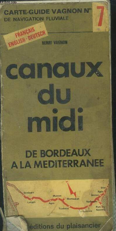
Vagnon Henri
Les canaux du midi de Bordeaux a la Méditerranée
plaisancier. Non daté. In-8. Broché. Etat d'usage, Plats abîmés, Dos satisfaisant, Intérieur frais. 53 pages illsutrées de cartes fluviales en couleurs..Couverture partiellement désolidarisée.. . . . Classification Dewey : 912-Atlas, cartes et plans
Ссылка продавца : RO40032756
|
|
|
VAISSETE dom Joseph
GÉOGRAPHIE HISTORIQUE, ÉCCLÉSIASTIQUE ET CIVILE, ou Description de toutes les Parties du Globe Terrestre, enrichie de Cartes Géographiques
paris Desaint & Saillant 1755 in-4 plein-veau 2 volumes (sur 4), reliure de l'époque plein veau brun raciné (binding full calfskin) in-quarto (20 x 25,7 cm), dos à nerfs (spine with raised bands) décoré or (gilt decoration) filets or (gilt line) et filets à froid (blind-stamping line decoration), entre-nerfs à compartiments à fleuron au fer plein (floweret with full blocking stamp) avec rinceaux aux angles, titres et tomaisons frappés or (gilt title), pièces de titre avec double filets or sur fond bordeaux et pièce de tomaison avec filet et roulette or sur fond chocolat, les coiffes supérieures manquent, les coiffes inférieures sont légèrement accidentées, le mors supérieur du tome 2 est fendu en partie, mais la reliure reste solide, plats décorés à froid d'un triple filet à froid en encadrement, double filets or sur les coupes (fillets on the cuts) avec légers manques de dorure (blurred gilding), coins écornés avec manque de cuir, toutes tranches jaspées (all marbled edges) bleue (blue marbled edges), orné d'une mappemonde en double page gravée sur bois en couleurs + 13 cartes dépliantes hors-texte gravées sur bois en couleur pour le tome 1 et 26 cartes dépliantes hors-texte gravées sur bois en couleur pour le tome 2 et orné de bandeaux et lettrines (illuminated of headpieces and dropped initials) gravés sur Bois (engraving-wood) en noir, (XVI + 498) + (VIII + 543) pages Avec approbation, & privilége du Roi, A Paris, Chez Desaint & Saillant, rue Saint Jean de Beauvais. Jean-Thomas Herissant, rue Saint-Jacques. Jacques Barois, quai des Augustins Editeurs,
Ссылка продавца : 18754
|
|
|
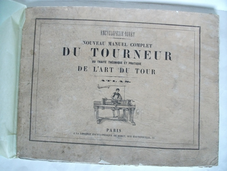
VALICOURT DE SERANVILLIERS Edmond de)
ATLAS du Nouveau manuel complet du tourneur ou traité théorique et pratique de l’Art du Tour
Grand in 8 broché,à l’italienne couverture avec titre et vignette.Faux-titre,titre avec vignette,suite de 25 planches gravées, la dernière est dépliante(une déchirure) Librairie encyclopédique de RORET sans date(vers 1850?) quelques très petites déchirures en marges réparées,Assez bon état d’ensemble.Peu courant
Ссылка продавца : 5448
|
|
 Получить результаты поиска по электронной почте
 Загрузить результаты в формате PDF
  RSS-канал


