|
Universal Cyclopaedia and Atlas; Adams Charles Kendall Ed.
Universal Cyclopaedia and Atlas Political Map of the United States- Original 1902
D. Appleton and Company 1902. No Binding. Fine. This rare hand colored map of the United States is from is from Volume XII of the 1902 edition the highly acclaimed Universal Cyclopaedia and Atlas.It depects the political boundaries of the Lower 48 states and territories. Plate size: 9.25" x 13" 23.5 x 33 cm; Margins: Minimum 1/2" 1.3 cm. Condition: Fine with central fold as issued. Additional photos available upon request. All items carefully packed to avoid damage from moisture and rough handling. D. Appleton and Company unknown
书商的参考编号 : 004632

|
|
|
Universal Cyclopaedia and Atlas; Adams Charles Kendall Ed.
Universal Cyclopaedia and Atlas Map of Brooklyn New York - Original 1902
D. Appleton and Company 1902. No Binding. Fine. This rare original hand colored map of the the Borough of Brooklyn New York is from Volume II of the 1902 edition of the acclaimed Universal Cyclopaedia and Atlas by D. Appleton and Company. Streets public buildings colleges hospitals rail depots hotels theatres and churches are clearly identified. Plate size: - 9" x 12" 23 x 30 cm; Margins: - Min 1/2in 1.2 cm. Condition: Fine; central fold as issued. On obserse sides are engravings of the East River Bridge and the Approach to the East River Bridge New York side. Additional photos available upon request. All items carefully packed to avoid damage from moisture and rough handling. D. Appleton and Company unknown
书商的参考编号 : 004570

|
|
|
Universal Cyclopaedia and Atlas; Adams Charles Kendall Ed.
Universal Cyclopaedia and Atlas Map of Buffalo New York - Original 1902
D. Appleton and Company 1902. No Binding. Fine. This rare original hand colored map of the the City of Buffalo New York is from Volume II of the 1902 edition of the acclaimed Universal Cyclopaedia and Atlas by D. Appleton and Company. Streets public buildings colleges hospitals rail depots hotels theatres and churches are clearly identified. Plate size: - 12" x 9" 30 x 23 cm; Margins: - Min 1/2in 1.2 cm; Margins: - Min 1/2in 1.2 cm. Condition: Fine; central fold as issued. Additional photos available upon request. All items carefully packed to avoid damage from moisture and rough handling. D. Appleton and Company unknown
书商的参考编号 : 004571

|
|
|
Universal Cyclopaedia and Atlas; Adams Charles Kendall Ed.
Universal Cyclopaedia and Atlas Map of Arkansas - Original 1902
D. Appleton and Company 1902. No Binding. Fine. This rare original hand colored map of Arkansas is from Volume I of the 1902 edition of the acclaimed Universal Cyclopaedia and Atlas by D. Appleton and Company. Counties are distinguished by color. Cities towns roads and rail lines are clearly depicted. Plate size: - 6" x 9 " 15 x 23 cm. Margins: - Min 1/2 in 1.2cm. Condition: Fine Additional photos available upon request. All items carefully packed to avoid damage from moisture and rough handling. D. Appleton and Company unknown
书商的参考编号 : 004584

|
|
|
Universal Cyclopaedia and Atlas; Adams Charles Kendall Ed.
Universal Cyclopaedia and Atlas Map of Washington State - Original 1902
D. Appleton and Company 1902. No Binding. Fine. This rare original hand colored lithographic map of Washington State is from Volume XII of the 1902 edition of the acclaimed Universal Cyclopaedia and Atlas Counties are distinguished by color. Cities towns roads rail lines and geographical features are clearly depicted. n. Plate size: - 6 about 6x9" Additional photos available upon request. All items carefully packed to avoid damage from moisture and rough handling. D. Appleton and Company unknown
书商的参考编号 : 004643

|
|
|
Universal Cyclopaedia and Atlas; Adams Charles Kendall Ed.
Universal Cyclopaedia and Atlas Map of Baltimore Maryland - Original 1902
D. Appleton and Company 1902. No Binding. Fine. This rare original hand colored map of the City of Baltimore Maryland is from Volume I of the 1902 edition of the acclaimed Universal Cyclopaedia and Atlas by D. Appleton and Company. Streets public buildings colleges hospitals rail depots hotels theatres and churches are clearly identified. Plate size: - 9" x 12" 23 x 30 cm; Margins: - Min 1/2in 1.2 cm. Condition: Fine; central fold as issued. Additional photos available upon request. All items carefully packed to avoid damage from moisture and rough handling. D. Appleton and Company unknown
书商的参考编号 : 004588

|
|
|
Universal Cyclopaedia and Atlas; Adams Charles Kendall Ed.
Universal Cyclopaedia and Atlas Map of Alabama - Original 1902
D. Appleton and Company 1902. No Binding. Fine. This rare original hand colored map of Alabama is from Volume I of the 1902 edition of the acclaimed Universal Cyclopaedia and Atlas by D. Appleton and Company. Counties are distinguished by color. Cities towns roads and rail lines are clearly depicted. Plate size: - 9" x 6 3/4" 23 x 17 cm. Margins: - Min 1/2in 1.2cm. Condition: Fine Additional photos available upon request. All items carefully packed to avoid damage from moisture and rough handling. D. Appleton and Company unknown
书商的参考编号 : 004578

|
|
|
Unknown editor Atlas Portland Cement Co.
Concrete Construction About the Home and on the Farm
NY: Atlas Portland Cement Company 1905. First Edition First Printing; college library plate/stamp; 127 clean unmarked pages; small chip at lower tips. 1st. Paperback. Very Good. Illus. by B/W Photos. 8 vo. Atlas Portland Cement Company Paperback
书商的参考编号 : 058101

|
|
|
unspecified; author of historical geography for atlas was William F. Collier
Maps of Britain--Historical: Britain and British Islands set of 3 maps
William Collins Sons & Company Ltd Glasgow london Edinburgh c. 1878. Broad outline and divisional color vg. The 3 maps sold as set are: 1. Historical Map of the British Islands with numerous founding dates and the location and date of the Spanish Armada 2. Britain Under the Saxons 3. Britain Under the Romans Each small map is 23x15cm. William Collins, Sons, & Company Ltd, Glasgow (london, Edinburgh), c. 1878 unknown
书商的参考编号 : 133
|
|
|
Unverhau, Dagmar
Stormarn in alten Karten und Beschreibungen. Ein Beitrag zur "Newen Landesbeschreibung Der Zwey Hertzogthümer Schleswich und Holstein" (1652) von Caspar Danckwerth und Johannes Mejer.
Neumünster., Wachholtz Verlag., 1994. 195S. Mit 32 Abbildungen (meist Karten) im Text, 5 Farbkarten (Teilweise doppelseitig), und 24 Schwarzweiß-Karten im Anhang. Zustand: Aus einer Seminarbibliothek ausgeschieden, unterer Rücken mit minimal Kleberesten eines ehemaligen Aufklebers, Vortitelblatt mit Institusstempel. Einbandkanten minimal berieben. 2°. OHalbleinen.
书商的参考编号 : 041032
|
|
|
urban atlas
URBAN ATLAS TRACT DATA FOR STANDARD METROPOLITAN STATISTICAL AREAS NEW YORK NEW YORK
Washington 1974 U. S. Department of Commerce. Oblong folio about 80pp. maps original printed wraps. A few Depository Library marks on covers maps clean. VG light vertical crease. . paperback
书商的参考编号 : a74346
|
|
|
urban atlas
URBAN ATLAS TRACT DATA FOR STANDARD METROPOLITAN STATISTICAL AREAS ALBANY-SCHENECTADY NEW YORK
Washington 1974 U. S. Department of Commerce. Oblong folio about 30pp. maps original printed wraps. A few Depository Library marks on covers maps clean. VG light vertical crease. . paperback
书商的参考编号 : a74345
|
|
|
urban atlas
URBAN ATLAS TRACT DATA FOR STANDARD METROPOLITAN STATISTICAL AREAS SYRACUSE NEW YORK
Washington 1974 U. S. Department of Commerce. Oblong folio about 30pp. maps original printed wraps. A few Depository Library marks on covers maps clean. VG light vertical crease. . paperback
书商的参考编号 : a74344
|
|
|
USSR Soviet Union Communist Era Geography Atlas of Maps
USSR Geographical Atlas for Secondary School Teachers
Moscow U.S.S.R.: MVD Ministry of Internal Affairs USSR 1959. viii 191 pages; useful index. Very well-printed lithographed color maps and charts. With geographic maps maps and charts of the solar system physical features climate world and country-by-country maps; more than half of the atlas concerns the then-U.S.S.R; text entirely in Cyrillic. Laid-in is an article from the NY Times Jan. 28 1973: 'Chinese Names for Towns in Siberia are Eliminated.' The volume approx. 10 3/4" x 15" size; bound in red cloth gilt cover and spine titles dulled; some edge tips wear and rubbing to the boards; contents clean maps' coloring bright and in very good condition. . First Edition. Hard Cover. Very Good. MVD (Ministry of Internal Affairs USSR) hardcover books
书商的参考编号 : 25043

|
|
|
Ute Friesen
Kinderatlas Wetter
Schwager & Steinlein 2008 48 pages 25 2x1x32cm. 2008. Broché. 48 pages.
书商的参考编号 : 500100843

|
|
|
VAB REMOORTERE JULIEN / ELIAS GUIDO
AUTOGUIDE FRANCE - ATLAS TOURISTIQUE - 2500 LIEUX ET 5000 CUIRIOSITES.
TOURING. 2000. In-8. Relié. Bon état, Couv. convenable, Dos satisfaisant, Intérieur frais. 721 pages - nombreuses photos et plans en couleur dans le texte - + un INDEX des noms, des lieux et regions naturelles.. . . . Classification Dewey : 912-Atlas, cartes et plans
书商的参考编号 : R320112553
|
|
|
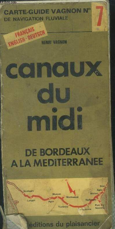
Vagnon Henri
Les canaux du midi de Bordeaux a la Méditerranée
plaisancier. Non daté. In-8. Broché. Etat d'usage, Plats abîmés, Dos satisfaisant, Intérieur frais. 53 pages illsutrées de cartes fluviales en couleurs..Couverture partiellement désolidarisée.. . . . Classification Dewey : 912-Atlas, cartes et plans
书商的参考编号 : RO40032756
|
|
|
VAISSETE dom Joseph
GÉOGRAPHIE HISTORIQUE, ÉCCLÉSIASTIQUE ET CIVILE, ou Description de toutes les Parties du Globe Terrestre, enrichie de Cartes Géographiques
paris Desaint & Saillant 1755 in-4 plein-veau 2 volumes (sur 4), reliure de l'époque plein veau brun raciné (binding full calfskin) in-quarto (20 x 25,7 cm), dos à nerfs (spine with raised bands) décoré or (gilt decoration) filets or (gilt line) et filets à froid (blind-stamping line decoration), entre-nerfs à compartiments à fleuron au fer plein (floweret with full blocking stamp) avec rinceaux aux angles, titres et tomaisons frappés or (gilt title), pièces de titre avec double filets or sur fond bordeaux et pièce de tomaison avec filet et roulette or sur fond chocolat, les coiffes supérieures manquent, les coiffes inférieures sont légèrement accidentées, le mors supérieur du tome 2 est fendu en partie, mais la reliure reste solide, plats décorés à froid d'un triple filet à froid en encadrement, double filets or sur les coupes (fillets on the cuts) avec légers manques de dorure (blurred gilding), coins écornés avec manque de cuir, toutes tranches jaspées (all marbled edges) bleue (blue marbled edges), orné d'une mappemonde en double page gravée sur bois en couleurs + 13 cartes dépliantes hors-texte gravées sur bois en couleur pour le tome 1 et 26 cartes dépliantes hors-texte gravées sur bois en couleur pour le tome 2 et orné de bandeaux et lettrines (illuminated of headpieces and dropped initials) gravés sur Bois (engraving-wood) en noir, (XVI + 498) + (VIII + 543) pages Avec approbation, & privilége du Roi, A Paris, Chez Desaint & Saillant, rue Saint Jean de Beauvais. Jean-Thomas Herissant, rue Saint-Jacques. Jacques Barois, quai des Augustins Editeurs,
书商的参考编号 : 18754
|
|
|
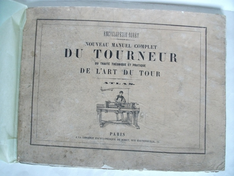
VALICOURT DE SERANVILLIERS Edmond de)
ATLAS du Nouveau manuel complet du tourneur ou traité théorique et pratique de l’Art du Tour
Grand in 8 broché,à l’italienne couverture avec titre et vignette.Faux-titre,titre avec vignette,suite de 25 planches gravées, la dernière est dépliante(une déchirure) Librairie encyclopédique de RORET sans date(vers 1850?) quelques très petites déchirures en marges réparées,Assez bon état d’ensemble.Peu courant
书商的参考编号 : 5448
|
|
|
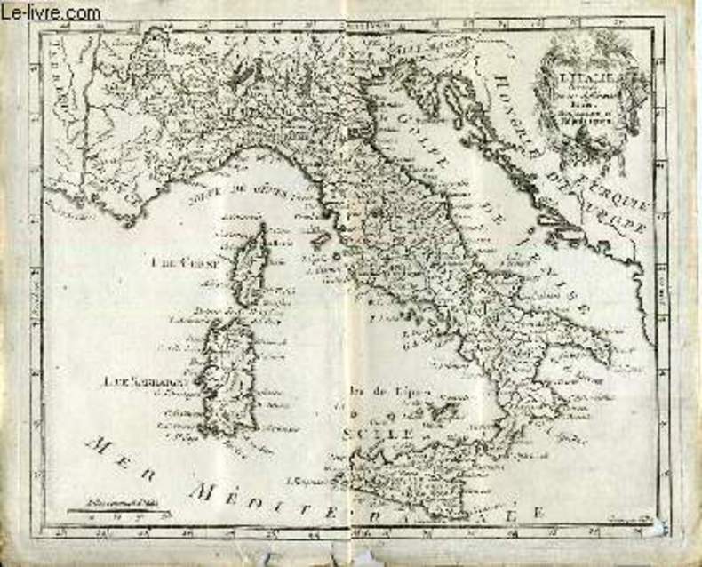
Vallet
Atlas moderne ou collection de cartes sur toutes les parties du globe terrestre carte de l'Italie divisée en ses différents états et royaumes et républiques
Laporte. 1777. In-12. En feuillets. Bon état, Couv. convenable, Dos satisfaisant, Intérieur frais. Carte noir et blanc, sur papier à la forme,( 24/20 cm) gravé par Vallet, échelle Milles lieues d'Italie.. . . . Classification Dewey : 912-Atlas, cartes et plans
书商的参考编号 : RO20020325
|
|
|
VALLAUD PIERRE & ALII
ATLAS HACHETTE, LA PUISSANCE ECONOMIQUE
Hachette. 1990. In-4. Broché. Bon état, Couv. convenable, Dos satisfaisant, Intérieur frais. 231 pages. Illustré de très nombreux graphiques, schémas, photos et cartes en couleur dans le texte.. . . . Classification Dewey : 912-Atlas, cartes et plans
书商的参考编号 : RO40227925 ???????? : 2010155513
|
|
|
VALLOT H. & COLLECTIF
Commission de Topographie du Club Alpin Français. Procès-verbaux des Séances de l'année 1914
CLUB ALPIN FRANCAIS. 1914. In-8. En feuillets. Bon état, Livré sans Couverture, Dos satisfaisant, Intérieur acceptable. 3 fascicules de 12, 19 et 37 pages.. . . . Classification Dewey : 912-Atlas, cartes et plans
书商的参考编号 : RO80059977

|
|
|
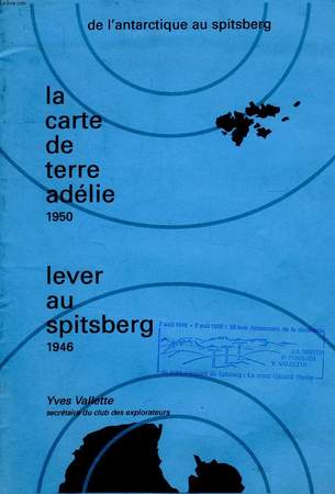
VALLETTE YVES
DE L'ANTARCTIQUE AU SPITSBERG, LA CARTE DE LA TERRE ADELIE 1950, LEVER AU SPITSBERG 1946
Association Françaises de Topographie. 1996. In-4. Broché. Bon état, Couv. convenable, Dos satisfaisant, Intérieur frais. 28 pages. Illustré de nombreux graphiques, cartes et photos en noir et blanc. Texte sur 2 colonnes.. . . . Classification Dewey : 912-Atlas, cartes et plans
书商的参考编号 : RO40113116
|
|
|
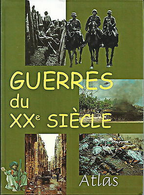
VALLAUD (Pierre) et Mathilde AYCARD.
Guerres du XXe siècle. Atlas.
GLM, 2000, gr. in-8°, 120 pp, 113 cartes en couleurs, chronologie des conflits, reliure souple illustrée de l'éditeur, bon état
书商的参考编号 : 120731
|
|
|
VALICOURT DE
NOUVEAU MANUEL COMPLET DU TOURNEUR. ATLAS.
Paris Librairie Encyclopédique de Roret sd v 1870. In-8 54 feuillets non chiffrés. Demi toile chagrinée verte à coins, dos lisse, rel époque. Atlas composé de 27 planches sur double page regroupant environ 1060 sujets: outils, machines, pièces détachées, exemples de décors. restauration ancienne au verso d'une planche, quelques rousseurs.
书商的参考编号 : GIT0154d
|
|
|
Valenti Devan/ Atlas Simon
Green is Not a Colour: Environmental Issues Every Generation Needs to Know Lightning Lab
Lightning Lab 2015. Paperback. New. 368 pages. 9.69x7.80x1.02 inches. Lightning Lab paperback
书商的参考编号 : __0620660163 ???????? : 0620660163 9780620660167
|
|
|
VALLAUD PIERRE & ALII
ATLAS HACHETTE, LA PUISSANCE ECONOMIQUE
ISBN : 2010155513. Hachette. 1990. In-4 Carré. Broché. Bon état. Couv. convenable. Dos satisfaisant. Intérieur frais. 231 pages. Illustré de très nombreux graphiques, schémas, photos et cartes en couleur dans le texte. Sous la dir. de P. Vallaud. 12 photos, 300 cartes et schémas en couleur, 40 pages de statistiques, glossaire, index.

|
|
|
VALLETTE YVES
DE L'ANTARCTIQUE AU SPITSBERG, LA CARTE DE LA TERRE ADELIE 1950, LEVER AU SPITSBERG 1946
Association Françaises de Topographie. 1996. In-4 Carré. Broché. Bon état. Couv. convenable. Dos satisfaisant. Intérieur frais. 28 pages. Illustré de nombreux graphiques, cartes et photos en noir et blanc. Texte sur 2 colonnes. Paul-Emile Victor. La carte de Terre Adélie. Spitsberg 1946, le mont Général Perrier...

|
|
|
VAN DER MEER FREDERIC
ATLAS DE LA CIVILISATION OCCIDENTALE
Elsevier. 1952. In-Folio. Relié. Bon état, Couv. convenable, Dos satisfaisant, Intérieur frais. 227 pages. Illustré de nombreuses photos en noir et blanc et cartes en couleur hors texte. Jaquette abîmée.. Avec Jaquette. . . Classification Dewey : 912-Atlas, cartes et plans
书商的参考编号 : RO40129103

|
|
|
VAN DER MEER Frédéric
Atlas de la Civilisation Occidentale
ELSEVIER. 1952. In-Folio. Relié toilé. Bon état, Couv. légèrement passée, Dos satisfaisant, Intérieur frais. 227 pages. Nombreuses illustrations et héliogravures en noir et blanc dans le texte et en planches hors-texte. Nombreuses planches de cartes en couleurs, hors-texte. Relié pleine toile beige. Jaquette en l'état, avec du scotch.. Avec Jaquette. . . Classification Dewey : 912-Atlas, cartes et plans
书商的参考编号 : RO20049147
|
|
|
VAN DER MEER FREDERIC
ATLAS DE LA CIVILISATION OCCIDENTALE.
ELSEVIER. 1952. In-Folio. Relié. Bon état, Couv. convenable, Dos satisfaisant, Intérieur frais. 227 pages - jaquette conservée - petite annotation au stylo bleu sur la page de faux titre - nombreuses cartes en couleurs hors texte - nombreuses illustrations en monochrome dans et hors texte.. Avec Jaquette. . . Classification Dewey : 912-Atlas, cartes et plans
书商的参考编号 : R240081371
|
|
|
VAN DER HEYDEN ANTOINE
ATLAS DE L'ANTIQUITE CLASSIQUE -
SEQUOIA. 1961. In-Folio. Relié. Bon état, Couv. convenable, Dos satisfaisant, Intérieur frais. 218 pages augmentées de nombreuses illustrations en noir et blanc dans et hors texte - Nombreuses cartes en couleurs hors texte - Jaquette en bon etat - Emboitage cartonné semi rigide defraichi et lerement dechiré. (brut).. Avec Jaquette. Sous Emboitage. . Classification Dewey : 912-Atlas, cartes et plans
书商的参考编号 : R320076074
|
|
|
Van Rose Suzsanna
Atlas jeunesse de la terre
France loisris / Seuil. 1996. In-Folio. Relié. Bon état, Couv. convenable, Dos satisfaisant, Intérieur frais. 63 pages. Nombreuses illustrations en couleur, dans le texte.. . . . Classification Dewey : 912-Atlas, cartes et plans
书商的参考编号 : R200117068

|
|
|
VAN DER MEER, Frédéric:
Atlas de la civilisation occidentale. 2ème édition. Préface de René Grousset.
Paris, Elsevier, 1951, gr. in-4to, 228 p., photogr. & cartes, reliures en toile originales.
书商的参考编号 : 68931aaf
|
|
|
Vandermaelen, Philippe Marie Guillaume :
Atlas Universel de géographie physique, politique, statistique et minéralogique, sur l'échelle de 1/1641836 ou d'une ligne par 1900 toises. D'après les meilleurs cartes, observations astronomiques et voyages dans les divers pays de la terre. Lithographié par H. Ode.
Bruxelles, PMG Vandermaelen éditeur, 1827 ; cinq tomes (Europe, Asie, Afrique, Amérique Septentrionale, Amérique Méridionale), in-folio atlantique (52,5 x 36 cm) ; demi-veau havane à petits coins verts, dos à faux-nerfs dorés, palette décorative dorée en tête et en pied, titre doré, tranches marbrées (reliure uniforme de l'époque) ; 1- Europe : (4), 43 pp., (1) p., tableau comparatif des principales hauteurs du globe (illustré en couleurs), carte d'assemblage de l'Europe et 29 cartes doubles. 2- Asie : (6) pp., carte d'assemblage de l'Asie et 111 cartes doubles. 3- Afrique : (4) pp., tableau d'assemblage de l'Afrique et 60 cartes doubles. 4- Amérique Septentrionale : (4), tableau d'assemblage et tableau provisoire d'assemblage d'une partie de l'Amérique Seple et d'une partie de l'Amérique Méridionale et 77 cartes doubles. 5- Amérique Méridionale : (4), carte d'assemblage d'Amérique Méridionale et 44 cartes doubles. Toutes les cartes sont en couleurs à quelques rares exceptions près et montées sur onglets.
书商的参考编号 : 9452
|
|
|
VAN DER MEER Frédéric
Atlas de la civilisation occidentale.
Paris/Bruxelles, Elsevier, 1952 27 x 36, 227 pp., 946 illustrations photo. N/B, 52 cartes couleurs, cartonnage éditeur, bon état (2 cachets)
书商的参考编号 : 3197
|
|
|
VAN DER MEER Frédéric
Atlas de la civilisation occidentale.
Paris/Bruxelles, Elsevier 1952 In-4 relié. Bon état d’occasion.
书商的参考编号 : 72252
|
|
|
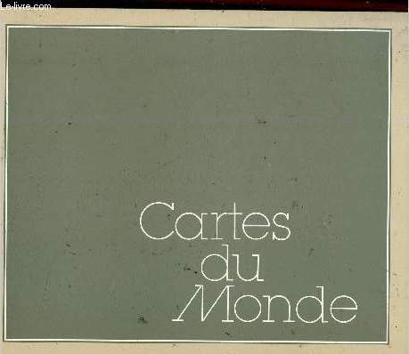
Van den Bossche
Cartes du Monde
Van den Bossche. Non daté. In-Folio. Broché. Bon état, Couv. défraîchie, Dos satisfaisant, Intérieur frais. Un planisphère en couleur In-Folio. 4 cartes de format In-8 en couleur. Le tout contenu dans une chemise en papier.. . . . Classification Dewey : 912-Atlas, cartes et plans
书商的参考编号 : RO30345764
|
|
|
VAN DEN KEERE Pieter [KAERIUS Petrus] (& KOEMAN C., introd.)
Germania Inferior id est, XVII Provinciarum ejus novae et exactae Tabulae Geographicae, cum Luculentis Singularum descriptionibus additis.
Amsterdam, Theatrum Orbis Terrarum 1966 xviii + 93pp.+ 24 double-page engraved maps, with engraved titlepage, Facsimile of the 1617-Amsterdam-edition, green cloth, dustwrapper, 45cm., in the series "Theatrum Orbis Terrarum. Third series of atlases in facsimile" vol.3
书商的参考编号 : B62065
|
|
|
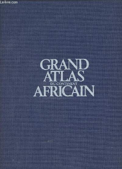
VAN CHI-BONNARDEL REGINE
GRAND ATLAS DU CONTINEN AFRICAIN.
JEUNE AFRIQUE. 1973. In-Folio. Relié toilé. Bon état, Couv. défraîchie, Dos satisfaisant, Intérieur acceptable. 335 pages illustrées de nomreuses cartes géographiques en couleur.. . . . Classification Dewey : 912-Atlas, cartes et plans
书商的参考编号 : R320005316
|
|
|
Van Chi-Bonnardel Regine
Grand Atlas du continent Africain
Editions Jeune Afrique. 1973. In-Folio. Relié toilé. Bon état, Couv. convenable, Dos satisfaisant, Intérieur frais. 335 pages augmentées de nombreuses cartes et graphiques en couleurs hors texte. Texte sur deux colonnes. Annotation à l'encre en page de garde.. . . . Classification Dewey : 912-Atlas, cartes et plans
书商的参考编号 : R240156539
|
|
|
VAN KEULEN, E.O. e.a.;
IN DE GEKROONDE LOOTSMAN ". HET KAARTEN-, BOEKUITGEVERS EN INSTRUMENTENMAKERSHUIS VAN KEULEN TE AMSTERDAM 1680 - 1885,
, Utrecht, HES Uitgevers, 1989, Gebonden, grijs linnen onder geillustreerde stofomslag, 205 x 245mm., 104pp., prachtige illustratie in kleur en z/w.
书商的参考编号 : 17838
|
|
|
VAN DER HEIJDEN, Henk A.M.
Nieut Kaert boeck vande XVII Nederlandsche Provincien, HERUITGAVE VAN DE ATLAS VAN DE NEDERLANDEN UITGEGEVEN DOOR F. DE WIT IN 1670-1672 MET EEN INLEIDING VAN H.A.M. VAN DER HEIJDEN. ReeDITION DE L?? ATLAS DES PAYS-BAS PUBLIe PAR F. DE WIT EN 1670-1672, ACCOMPAGNeE D?? UNE INTRODUCTION DE H.A.M.
, Leuven, U pers,1999., Bound, with dusjacket, in kunstlederen band, 40 p. - 51 x 31,50 cm, tweetalige inleiding (Nederlands-Frans) 20 p. facsimile tekst, 25 kaartbladen van 51 x 63 cm. ISBN 9789061868743.
书商的参考编号 : 15180
|
|
|
VANUXEM Jacques.
Recueil des Cartes des Places de Guerre des Provinces de Picardie, Champagne, Bretagne, Poitou, Pays d'Aunis, Guienne, Navarre et Biscaye, Languedoc, Dauphiné, Bourgogne ...
LAROUSSE. Non daté. In-4. En feuillets. Bon état, Couv. convenable, Dos satisfaisant, Intérieur frais. Lot de 19 planches de cartes en couleurs, de 30 x 39 cm. Dans une pochette rempliée. Réimpression de l'Edition de 1583. . . . Classification Dewey : 912-Atlas, cartes et plans
书商的参考编号 : RO80086425
|
|
|
VAN ERMEN Eduard
The United States in old maps and prints
Tielt, Lannoo 1990 144pp.with ills. of maps and prints in colour, 38cm., original edition, signed with dedication by the author, cloth with dustwrapper, very good condition, A74841
书商的参考编号 : A74841
|
|
|
VAN DEN KEERE Pieter [KAERIUS Petrus] (& KOEMAN C., introd.)
Germania Inferior id est, XVII Provinciarum ejus novae et exactae Tabulae Geographicae, cum Luculentis Singularum descriptionibus additis.
xviii + 93pp.+ 24 double-page engraved maps, with engraved titlepage, Facsimile of the 1617-Amsterdam-edition, green cloth, dustwrapper, 45cm., in the series "Theatrum Orbis Terrarum. Third series of atlases in facsimile" vol.3
|
|
|
Van Der Krogt, Peter
Joan Blaeu. Atlas Major 1665. Germania, Austria, Helvetia. 2 Bde.
Köln: Taschen 2010. zus. 403 S., mit zahlr. Kartenabb. 2° Kart.mS.iS. *neuwertig*
书商的参考编号 : 181088
|
|
|
VAN DER MEER FREDERIC
ATLAS DE LA CIVILISATION OCCIDENTALE
Elsevier. 1952. In-Folio Carré. Relié, Jaquette. Bon état. Couv. convenable. Dos satisfaisant. Intérieur frais. 227 pages. Illustré de nombreuses photos en noir et blanc et cartes en couleur hors texte. Jaquette abîmée. Préface de René Grousset. Les trois racines. La Chrétienté médiévale. Les cultures nationales et leur expansion...

|
|
|
VAN ERMEN Eduard
The United States in old maps and prints
144pp.with ills. of maps and prints in colour, 38cm., original edition, signed with dedication by the author, cloth with dustwrapper, very good condition, A74841
|
|
|
Van Houten, Cacao
Van Houten's kleiner Atlas in losen Blättern Seltene Ausgabe
Amsterdam, Van Houten ca. 1900. 8,5 x 10 cm - 18 Karten Karten gestempel mit W. Brokelmann ( wohl Cafe oder Vertrieb) Mappe mit losen farbigen Karten, Mappe beschrieben
书商的参考编号 : 59477

|
|
 ?????????
 ?????PDF???
 RSS feed


