|
WORLD ATLAS ORIGINAL HANDCOLOR
Fenner's Pocket Atlas of Modern and Ancient Geography.
London.: Robert Jennings. 1828. A self-identified "Pocket" Atlas 6 3/4 x 5 1/2 inches featuring 71 exquisitely hand-colored and highly detailed maps almost all in very good clean condition. Those of antiquity identified as "Classical" are 26 in number while 45 maps reflect contemporary cartography. Most maps measure approximately 6 1/2 x 5 1/4 inches although there are eight exceptions involving larger folding maps. These vary in size from 6 1/4 x 11 inches to 7 1/4 x 11 inches. The eight over-sized folding maps are identified with double numerals i.e. "20/21" on the contents page. They are titled "Eastern & Western Hemispheres" "Northern and Southern Polar Regions" "The World" "Central States of Europe as Settled by Congress in 1815" "Ottoman Empire" "Chinese Empire" "Canada New Brunswick & Nova Scotia" and "United States." A colorful folding chart titled "Principal Mountains & Principal Rivers" completes the volume. The hand-coloring is extremely delicate and the maps throughout demonstrate enormous attention to detail. The front cover and the free endpaper have come loose from the text block which is cracked but intact. The spine of volume has top to bottom vertical crack and loss at head; one of the oversize maps although clean and bright has been clumsily folded. The contents are a cartographic gem a beautifully engraved and handcolored depiction of the world as seen by European eyes 200 years ago. . Robert Jennings. unknown
書籍販売業者の参照番号
: 55200

|
|
|
World Atlas
HISTORICAL HAND-ATLAS
Chicago and Toledo: H.H. Hardesty & Co 1882. Hard Cover. Small Folio. Illustrated containing large scale copper plate maps of each state and territory of the United States and the provinces of Canada together with a complete reference map of the world topographical and railroad map of the United States thirteen comprehensive maps of Bible geography covering all the countries of Bible history with classified pronunciative index of each map printed in colors from plates secured by letters patent producing the clearest typographical effect of any known engraved plates accompanied by a general survey of the world history of the United States-History of each state and territory of the United States outline map and history of Lawrence County Ohio. Containing a condensed history of the County; Biographical sketches; general statistics; miscellaneous matters etc. Frontispiece depicts Geysers in the Yellowstone Valley 60 of 61maps present lacking #44 &45 which is the United States the five folding maps are on stubs and printed on a much thinner paper with the map of New York laid in closed tear on map #164 small loss at lower edge of map #165. Re-backed and cornered in brown leather retaining original gilt stamped brown cloth endpapers renewed. A very good copy with excellent maps. <br/><br/> H.H. Hardesty & Co hardcover
書籍販売業者の参照番号
: 6274

|
|
|
WORLD ATLAS
RAND MCNALLY WORLD ATLAS
RAND MCNALLY 1953 1953-01-01. Hardcover. Very Good. RAND MCNALLY 1953 hardcover
書籍販売業者の参照番号
: 181212027
|
|
|
World Atlas
The Signet World Atlas: Completely Revised and Updated
Signet 1998-08-01. Revised. Mass Market Paperback. Used:Good. Signet paperback
書籍販売業者の参照番号
: DADAX0451197321 ISBN : 0451197321 9780451197320

|
|
|
World Atlas Hammond Incorporated Incorporated
World Atlas Hammond
New. slight shelf wear pb unknown
書籍販売業者の参照番号
: SKU1006131 ISBN : 0843724994 9780843724998
|
|
|
World Atlas
HISTORICAL HAND-ATLAS
Chicago and Toledo: H.H. Hardesty & Co 1882. Hard Cover. Small Folio. Illustrated containing large scale copper plate maps of each state and territory of the United States and the provinces of Canada together with a complete reference map of the world topographical and railroad map of the United States thirteen comprehensive maps of Bible geography covering all the countries of Bible history with classified pronunciative index of each map printed in colors from plates secured by letters patent producing the clearest typographical effect of any known engraved plates accompanied by a general survey of the world history of the United States-History of each state and territory of the United States outline map and history of Lawrence County Ohio. Containing a condensed history of the County; Biographical sketches; general statistics; miscellaneous matters etc. Frontispiece depicts Geysers in the Yellowstone Valley 60 of 61maps present lacking #44 &45 which is the United States the five folding maps are on stubs and printed on a much thinner paper with the map of New York laid in closed tear on map #164 small loss at lower edge of map #165. Re-backed and cornered in brown leather retaining original gilt stamped brown cloth endpapers renewed. A very good copy with excellent maps. <br/><br/> H.H. Hardesty & Co hardcover books
書籍販売業者の参照番号
: 6274
|
|
|
World War I Atlas: Cram Company George F. publisher
UNITED STATES AT WAR AMERICAN WAR ATLAS . wrapper title
Chicago: George F. Cram Company 1918. 16pp. Folio 38 x 29 cm. Pictorial self-wrapper. Minute tear at fore-edge of first two leaves some neat annotations in colored pen in margins of three maps otherwise an unusually nice copy of a very fragile item. "Corrected and Revised Edition" including maps of the world with shipping routes Europe the Western Theatre Eastern Europe Russia Germany Italy Turkey and the US showing training camps all with details relevant to the war at that point. George F. Cram Company unknown
書籍販売業者の参照番号
: WRCLIT79134

|
|
|
World War I Atlas: Cram Company George F. publisher
UNITED STATES AT WAR AMERICAN WAR ATLAS . wrapper title
Chicago: George F. Cram Company 1918. 16pp. Folio 38 x 29 cm. Pictorial self-wrapper. Minute tear at fore-edge of first two leaves some neat annotations in colored pen in margins of three maps otherwise an unusually nice copy of a very fragile item. "Corrected and Revised Edition" including maps of the world with shipping routes Europe the Western Theatre Eastern Europe Russia Germany Italy Turkey and the US showing training camps all with details relevant to the war at that point. George F. Cram Company unknown books
書籍販売業者の参照番号
: WRCLIT79134
|
|
|
WorldSat International Inc
Spotlight Erde - Der Satelliten-Weltatlas,
Gütersloh, Bertelsmann (= Bertelsmann Lexikon), 2011. 4°, 288 S. , mit zahlreichen ganzseitigen Farbabbildungen, farbig illustr. original Pappband (Hardcover), Erstausgabe Zustand wie frisch aus der Buchhandlung.
書籍販売業者の参照番号
: 10804BB

|
|
|
Wotte, Herbert und Siegfried Hoyer
TOURIST Stadtführer-Atlas Dresden
Berlin, Leipzig, VEB Tourist Verlag, 1979. 176 Seiten , 19 cm, Hardcover/Pappeinband
書籍販売業者の参照番号
: 32861

|
|
|
WRIGHT JILL ET DAVID.
ATLAS DE POCHE.
ISBN : 2724222601. GP. 1984. In-12 Carré. Cartonnage d'éditeurs. Bon état. Couv. convenable. Dos satisfaisant. Intérieur frais. 189 pages. Nombreuses illustrations en noir et blanc et en couleurs dans le texte et hors texte. Traduction de ODILE RICKLIN.

|
|
|
WUHRER / GAY
Carte du Vicariat Apostolique de la Mongolie.
LES MISSIONS CATHOLIQUES. 15 oct. 1875. In-4. En feuillets. Bon état, Couv. convenable, Dos satisfaisant, Intérieur frais. Carte en noir et blanc de 44/30 cm. Pas de plats de couverture.. . . . Classification Dewey : 912-Atlas, cartes et plans
書籍販売業者の参照番号
: RO80006286
|
|
|
WUHRER / GAY
Carte partielle du Royaume d'Annam (Tong-King) 1874
LES MISSIONS CATHOLIQUES. 1874. In-Folio. En feuillets. Etat d'usage, Couv. convenable, Dos satisfaisant, Intérieur frais. Carte en noir et blanc, de 44/30 cm. Trait au feutre rouge. Pas de plats de couverture.. . . . Classification Dewey : 912-Atlas, cartes et plans
書籍販売業者の参照番号
: RO80006284
|
|
|
Wurzer, Rudolf (Hrsg.)
Strukturanalyse des österreichischen Bundesgebietes. Kartenband. (= Sonderausgabe im Rahmen der Schriftenreihe der Österreichischen Gesellschaft für Raumforschung und Raumplanung)
Wien, Österreichische Gesellschaft für Raumforschung und Raumplanung 1970. 4°. [ca. 250] Bl.. u. 4 gefaltete Beilagen, OPpbd., ausgeschied. Bibl.-Ex. mit den üblichen Kennzeichnungen, sehr gut erhalten.
書籍販売業者の参照番号
: AUST2353
|
|
|
Wustmann, Gustav Dr
Leipzig durch drei Jahrhunderte
Leipzig, Duncker und Humblot, 1891. Gr. Folio (41x29cm), 6 nn. S., VIII, 24 S., 69 teils ausfaltbare Karten und Stahlstiche, Ganzleineneinband
書籍販売業者の参照番号
: 7-3-626

|
|
|
WUTHRICH Lucas Heinrich
Merian Europa, neunaundachtzig der schonesten Stadtebilder aus der archontologie und den topographien, mit einem Geleitwort von Lucas Heinrich Wuthrich
Barenteiter Verlag Kassel et Basel. 1965. In-8. Relié toilé. Bon état, Couv. convenable, Dos satisfaisant, Intérieur frais. 90p, illustré de 89 gravures sur planches rempliées donnant une vue panoramique.+ une carte de l'Europe.. . . . Classification Dewey : 912-Atlas, cartes et plans
書籍販売業者の参照番号
: RO20017060
|
|
|
WW. Hixson Map & Atlas Co. W. W.
Plat Book of the State of Minnesota
Rockford Ill.: W.W. Hixson & Co. Soft cover. Very Good. ca. 1930s. The County population data is based on the Census estimate of 1933. red oblong wraps containing maps of all counties as well as lists of each county population & area rivers of Minnesota and a list of all cities and towns with populations of each. <br/> <br/> W.W. Hixson & Co. paperback
書籍販売業者の参照番号
: 10102406
|
|
|
WYSS, J. Rud. (Johann Rudolph):
Reise in das Berner Oberland. Zweite Abtheilung (= nur Band 2 von 2).
Bern, J.J. Burgdorfer, 1817, gr. in-8vo, 1 Titelbl. mit Kupfervign. + VII + 1 S. Verbess. + (S. 405)-914 + 2 Bl. Anzeigen. (Ex- ohne Kupfertafeln), H.-Lederbände d. Zeit.
書籍販売業者の参照番号
: 135607aaf
|
|
|
Wölfle (Hrsg.), Karl, Dr. Hans Schröder und Max Fehring
Hamburger Geschichtsatlas.
Hamburg, L. Friederichsen & Co., 1926. 48 S. 4° Quart, Halbleinen
書籍販売業者の参照番号
: 80484

|
|
|
Wölfle, Karl (Hrsg.)
Hamburger Geschichtsatlas. Heimatkundliche Karten und Bilder. In Verbindung m. Hans Schröder (Museum für Hamburgische Geschichte), Hans Schröder (Realschule Eilbek) u. Max Fehring hrsg.
Hamburg, Friederichsen & Co. 1926. 48 S. Mit 3 farb. Ktn. u. 147 tls. farb. Plänen u. Diagr. sowie Abb. i. Kpfr.-Tiefdruck. 4to. 31 cm. Orig.- GANZLEINEN.
書籍販売業者の参照番号
: 89406

|
|
|
Wölfle, Karl (Hrsg.)
Hamburger Geschichtsatlas. Heimatkundliche Karten und Bilder. In Verbindung m. Hans Schröder (Museum für Hamburgische Geschichte), Hans Schröder (Realschule Eilbek) u. Max Fehring hrsg.
Hamburg, Friederichsen & Co. 1926. 48 S. Mit 3 farb. Ktn. u. 147 tls. farb. Plänen u. Diagr. sowie Abb. i. Kpfr.-Tiefdruck. 4to. OHALBLEINEN.
書籍販売業者の参照番号
: 2216

|
|
|
Wüst, Manfried
Untersuchungen zu den siedlungsgeographischen Texten des Alten Testaments. Teil 1: Ostjordanland. [Von Manfried Wüst]. (= Beihefte zum Tübinger Atlas des vorderen Orients, Reihe B (Geisteswissenschaften), Nr. 9).
Wiesbaden: Reichert 1975. IX, 259 Seiten. Als Typoskript gedruckt. Mit 4 gefalteten Tabellen/Kartenbeilagen sowie die dazugehörigen Legenden als Beilage im Anhang. Gr. 8° (22,5-25 cm). Orig.-Broschur. [Softcover / Paperback].
書籍販売業者の参照番号
: 154065
|
|
|
Xiudong, Sun (Managing Editor) and Gu Lifen (Cartographic Examiner)
Atlas of the People's Republic of China
Foreign Languages Press, China Cartographic Publishing House, Beijing, 1989. 27 cm ; Pp.
書籍販売業者の参照番号
: 103698

|
|
|
Yeatman
ATLAS DES OISEAUX NICHEURS DE FRANCE
1976.Ministère environnement.Gd.in-8 demi-relié.282 p.Nombreuses figures et plans.Etat de neuf.Couvertures conservées.Dos orné de filets dorés et de la figure d'un oiseau.
書籍販売業者の参照番号
: 51466
|
|
|
YEATMAN Laurent
Atlas des oiseaux nicheurs de France.
Couverture souple. Broché. 282 pages. Couverture légèrement insolée.
書籍販売業者の参照番号
: 104008

|
|
|
Yeatman-Berthelot (Dosithée) ; Jarry (Guy)
Nouvel Atlas des oiseaux nicheurs de France
1995 Société ornithologique de France 1995 In-4 broché , 775 pp. Plus de 2400 ornithologues-enquêteurs qui ont relevé les indices de nidification, par secteurs de 30x27 km, à travers la totalité du pays. 290 espèces traitées ds cet ouvrage. Bon état
書籍販売業者の参照番号
: 5538
|
|
|
Yehuda Atlas
It's Me!
Lambda Publishers Incorporated 1985. Library Binding. Good. Disclaimer:A copy that has been read but remains in clean condition. All pages are intact and the cover is intact. The spine may show signs of wear. Pages can include limited notes and highlighting and the copy can include previous owner inscriptions. At ThriftBooks our motto is: Read More Spend Less.Dust jacket quality is not guaranteed. Lambda Publishers, Incorporated unknown
書籍販売業者の参照番号
: G0915361205I3N00 ISBN : 0915361205 9780915361205

|
|
|
Yehuda Atlas ; illus Dani Kerman
Stories I Loved Hebrew
Shva Publishers 1985. 78pp 21x27 cm Shva Publishers unknown
書籍販売業者の参照番号
: 7007 ISBN : 9652460214 9789652460219

|
|
|
Yehudah Atlas
It's Me
Modan Pub. Library Binding. VERY GOOD. Light rubbing wear to cover spine and page edges. Very minimal writing or notations in margins not affecting the text. Possible clean ex-library copy with their stickers and or stamps. Modan Pub unknown
書籍販売業者の参照番号
: 3191909158 ISBN : 0915361205 9780915361205
|
|
|
Yehudah Atlas
It's Me
1985-10-01. New. Ships with Tracking Number! INTERNATIONAL WORLDWIDE Shipping available. May be re-issue. Buy with confidence excellent customer service! unknown
書籍販売業者の参照番号
: 0915361205n ISBN : 0915361205 9780915361205

|
|
|
Yehudah Atlas Dani Kerman Illustrator
It's Me
Franklin Watts 1985-05-01. Library Binding. Used:Good. Franklin Watts unknown
書籍販売業者の参照番号
: DADAX0915361205 ISBN : 0915361205 9780915361205
|
|
|
Ylinen, Jari
Atlas der Muskeldehnungstechniken. Mit einem Geleitwort von Leon Chaitow. Deutsche Übersetzung von Walburga Rempe-Baldin.
München : Elsevier, Urban & Fischer, 2009. 1. Aufl.; VIII, 286 S.mit zahlreichen Abbildungen; 28 cm; Orig.-Broschur;
書籍販売業者の参照番号
: 122398

|
|
|
Yokochi, Chihiro und Johannes W. Rohen
Photographischer Atlas der Anatomie des Menschen.
Stuttgrt, F. K. Schattauer Verlag, 1971. 99 S. 4° Quart, Hardcover/Pappeinband
書籍販売業者の参照番号
: 101314

|
|
|
Yorkshire Wolds Way Adventure Atlas
Yorkshire Wolds Way Adventure Atlas
Geographers' A-Z Map Co Ltd 2017. Paperback. New. 1st edition. 44 pages. 9.13x5.04x0.31 inches. Geographers' A-Z Map Co Ltd paperback
書籍販売業者の参照番号
: __1782571949 ISBN : 1782571949 9781782571940

|
|
|
Yorkshire Wolds Way Adventure Atlas
Yorkshire Wolds Way Adventure Atlas
Geographers' A-Z Map Co Ltd 2017. Book. New. Paperback. New and in stock. Geographers' A-Z Map Co Ltd Paperback
書籍販売業者の参照番号
: 1782571949 ISBN : 1782571949 9781782571940
|
|
|
Young, Peter (Hrsg.)
Der grosse Atlas zum II. Weltkrieg.
München, Südwest, 1974. 2. Aufl./11.-20. Tsd. 288 S., m. 247 Kart. v. Richard Natkiel u. 262 Dokumentarfotos. Or.-Ln., Or.-Umschl., Deckelillustr., guter Zust. 20
書籍販売業者の参照番号
: 12363AB
|
|
|
Young, Peter (Hrsg.)
Der große Atlas zum II. Weltkrieg, aus dem Englischen von Dieter Marc Schneider,
München, Südwest Verlag, 1989. 4°, 288 S. mit 247 Karten und 262 s/w-Abbildungen, original illustr. Pappband, Sonderausgabe sehr schönes, sauberes Exemplar.
書籍販売業者の参照番号
: 18263CB

|
|
|
Young, Peter [Hrsg.]
Der grosse Atlas zum II. [zweiten] Weltkrieg.
München, Südwest-Verlag, 1974. 29 cm. 288 S., 262 Ill., 247 Kt. OLwd. m. Or. Umschl. Umschl. m. leichte Gebrauchspur. ansonsten Buch in gut. Zust.
書籍販売業者の参照番号
: 5656BB
|
|
|
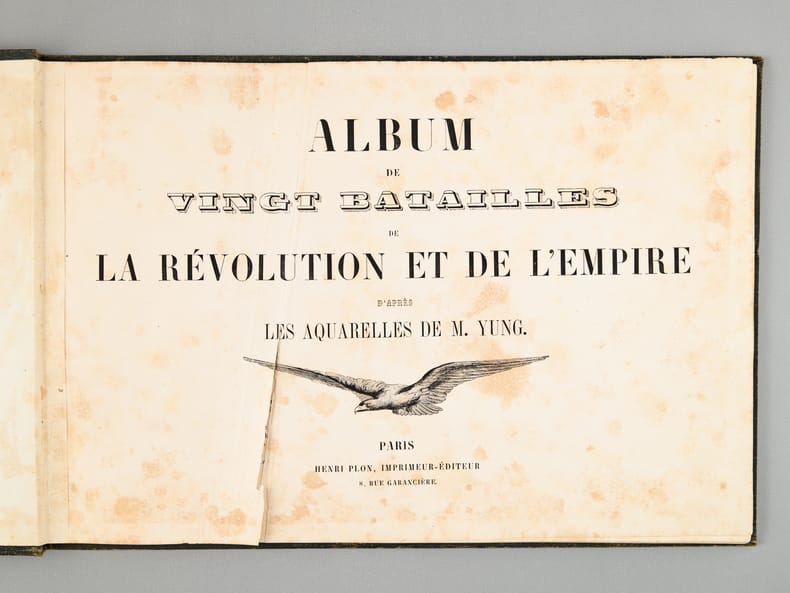
YUNG, M. ; [ JUNG, Théodore ]
Album de vingt Batailles de la Révolution et de l'Empire, d'après les aquarelles de M. Yung [ Contient : ] Siège de Toulon (décembre 1793), Sainte-Euphémie (3 juillet 1806), Prise de Gaëte (19 juillet 1806), Combat de Somo-Sierra (30 novembre 1808), La Corogne (16 janvier 1809), Prise d'Oporto (29 mars 1809), Siège de Saragosse (1808 et 1809), Talavera (27 et 28 juillet 1809), Ocana (10 septembre 1809), Passage de la Sierra-Morena (20 janvier 1810), Fuentes d'Oroño (5 mai 1811), Affaire de Brienne (29 janvier 1814), Combat de Champaubert (1814), Montmirail (11 février 1814), Montereau (18 février 1814), Craonne (7 mars 1814), Arcis-sur-Aube (20 mars 1814), bataille de Paris (30 mars 1814), bataille de Ligny (16 juin 1815), bataille de Waterloo (18 juin 1815)
1 vol. in-folio à l'italienne reliure pleine percaline verte, Henri Plon, Paris, s.d. [ vers 1860 ], 4 ff. et 20 planches sius serpentes gravées sur cuivre par Durond, Rouargue et Lalaisse, rehaussées en couleurs à la gouache et à l'aquarelle.
書籍販売業者の参照番号
: 68100
|
|
|
Yusupov Artur; Atlas Valerie; Neat Ken
The Petroff Defense
ZurichSwitzerland: Edition Olms 1999. Comprehensive text presents the most complete analysis of this classical king-pawn opening the Petroff Defense in which Black initiates a counter-attack on the second move in a stark attempt to equalise the game. Includes an encyclopaedic coverage of the variations with 244 training exercises and several annotated games. 434 pgs. Illustrated. First Edition. Pictorial Soft Cover. Fine. 8vo - over 7�" - 9�" tall. Edition Olms paperback
書籍販売業者の参照番号
: GA-3 ISBN : 3283004005 9783283004002

|
|
|
Zaborski, Bogdan
Atlas of Landscapes and Settlements of Eastern Canada/Atlas Des Paysages et De L'Habitat Du Canada De L'Est *SIGNED BY AUTHOR*
"The aim of this Atlas is to bring the reader's attention to essential geographical facts, visible on large-scale Canadian maps. The author has tried to give some explanations for the various forms of relief and patterns of human settlements, roads and boundaries. A selected bibliography, which includes research papers, has been placed at the end of each chapter. The atlas is intended as a tool in the teaching of Canadian geography in universities and colleges, and to some extent - general geography on examples, selected from the eastern part of Canada." - from page 128. Includes 610 cartographical illustrations. Bilingual English/French. Sir George Williams University, Department of Geography - Publication No. 1. Oblong 11" x 17". Signed and inscribed upon title page by author to a fellow-Professor in 1974. Average wear. Unmarked. A sound copy Book

|
|
|
Zahn, Ulf und Peter Maibach
Diercke Universalatlas
Braunschweig, Georg Westermann Verlag GmbH, 1984. 1. Auflage 47 Seiten , 30 cm , Leinen
書籍販売業者の参照番号
: 45668

|
|
|
Zanichelli - Nangeroni, Guiseppe u. Leonardo Ricci
Atlante geografico Zanichelli ad uso delle schuole. Nuova ed. migl. e agg.
Zanichelli, Bologna 1951. 183 S. mit zahlreichen farbigen Karten auf 139 Tafeln. 4°. Halbleinen. Leichte Gebrsp. Etwas locker u. berieben. Gutes Exemplar.
書籍販売業者の参照番号
: 9474
|
|
|
ZANNONI Rizzi
Atlas Géographique et MILITAIRE ou Théâtre de la Guerre présente en Allemagne.
Paris, chez Lattré et Bordeaux en 1761....." où sont marqués les Marches et Campemens des Armées, depuis l'entrée des Trouppes Prussiennes en Saxe en Aoust 1756, jusqu'au commencement de 1762. " 17 cartes gravées ,coloris d'époque, sur onglets reliées avec le Journal de la Guerre, présente en Allemagne. 64 pages + catalogue.In-32 en maroquin d'époque, triple filet sur les plats avec motif fleuri aux angles, dos orné avec pièce de titre, tranches dorées, nom effacé sur le 1er plat avec seulement initiale du prénom conservée. Ex-libris.TBE.
書籍販売業者の参照番号
: 33437
|
|
|
Zeissig, Hans. (Hrsg.)
Harms Geschichts- und Kulturatlas. Herausgegeben von Dr. Hans Zeissig unter Mitwirkung in- und ausländischer Historiker und der Verlagsredaktion.
München/Frankfurt/M. u.a., List., 1964. 4°. [19,8 : 26 cm]. 8 Tafeln mit vielen Schwarzweissabbildungen und 128/VIII farbig Kartenseiten. Illustrierter Originalpappband mit Kunststoffbezug und Illustrationen auf Vor-/Hintersatz. - Ein sehr gut erhaltenes, sauberes Exemplar ohne Eintragungen. 56. - 59. Auflage.
書籍販売業者の参照番号
: 6667BB

|
|
|
Zentner, Christian
Der grosse Bildatlas zur Weltgeschichte.
Stuttgart [i.e.] Remseck, Unipart-Verl., 1992. 30 cm. 608 S., Ill., Kt. Or.Pp. Eck. u. Kapital. leicht bestoss. ansonsten Buch in gut. Zust.
書籍販売業者の参照番号
: 6243BB
|
|
|
Zentner, Christian [Hrsg.]
Der grosse Bildatlas zur Weltgeschichte
München, List, 1982. 31 cm. 608 S. : überwiegend Ill. (farb.) u. Kt. Gewebe m OU. Bibliotheksstemp.u. Bibliotkeksaufleb. a Vors., sehr guter Zust.
書籍販売業者の参照番号
: 41726AB
|
|
|
Zentner, Christian [Hrsg.]
Der grosse Bildatlas zur Weltgeschichte
München, List, 1982. 31 cm. 608 S. : überwiegend Ill. (farb.) u. Kt. Gewebe Mittl. Gelenk gelockert, Schnitt leicht angeschm., 1 Biblioth.-Stempel a. Tit.-Bl.
書籍販売業者の参照番号
: 41176AB
|
|
|
Zentner, Christian [Hrsg.]
Der grosse Bildatlas zur Weltgeschichte.
München, List, 1982. 31 cm. 608 S., überwiegend Ill. (farb.) u. Kt. Gewebe, verg. Rü.-Tit., OU. OU leicht berieb., sauber u. gut erhalten.
書籍販売業者の参照番号
: 53132AB
|
|
|
Zentner, Christian [Mitverf.]
Der grosse Bildatlas zur Weltgeschichte.
Stuttgart, Unipart-Verl, 1985. 31 cm. 608 S., 600 Ill. (farb.) u. Kt. OK, Deck.-Ill. Schnitt leicht gebräunt, innen minim. braunrandig, sonst sauber u. gut erhalten. 1 Besitzer-Aufkleber a. Vorsatz.
書籍販売業者の参照番号
: 54244AB
|
|
 検索結果のメールを受信する
 PDFファイルの検索結果をダウンロード
 RSSフィード


