|
Beckel, Lothar: Gläßer, Ewald
Satellitenbild Atlas Nordrhein-Westfalen.
Berlin/Gütersloh/Leipzig/München/Potsdam/Werder/Stuttgart, RV Reise- und Verkehrsverlag, 1994. 4°, 80 S., Hg. von R. Winter und L. Beckel in Zusammenarb. mit der Deutschen Forschungsanstalt für Luft- und Raumfahrt, Bezahlung per PayPal möglich, we accept PayPal, min. Gebr.sp., Pappband, gebunden
Riferimento per il libraio : 21606
|
|
|
Becker, Friedrich (Bearb.)
Sternatlas. Nach der vierten [4.]. Auflage von Littrows Atlas des gestirnten Himmels vollständig neubearbeitet von Friedrich Becker. Mit einer Einleitung von J. Plassmann.
Berlin: Ferd. Dümmlers Verlagsbuchhandlung 1923. IV, 20, (4) Seiten + 16 Tafeln. 4° (29 x 22 cm). Orig.-Halbleinenband. [Hardcover / fest gebunden].
Riferimento per il libraio : 3111208

|
|
|
Becking, Gereon Christoph Maria (Verfasser)
Zisterzienserklöster in Europa. Kartensammlung. Studien zur Geschichte, Kunst und Kultur der Zisterzienser ; Bd. 11
Berlin : Lukas, 2000. 113 S. Originalbroschur.
Riferimento per il libraio : 1097119

|
|
|
Beckingham C. F. introduction Atlas
Atlas of the Arab World and the Middle East
London and New York: Macmillan and St Martin's Press 1960. Colored maps. Photos. Index. With an Introduction by C. F. Beckingham. Cover worn at edges and along spine and partially detached. Small private owner's bookplate inside front cover. approximately 68 pages. 34.5 cm. Hardcover. . Catalogs: MIDDLE EAST. London and New York: Macmillan and St Martin's Press, 1960 hardcover
Riferimento per il libraio : 8600
|
|
|
Beckouche Pierre & Richard Yann
Atlas d'une nouvelle Europe - L'Europe élargie et ses voisins Russie, Proche-Orient, Maghreb - Collection atlas/mémoires.
Autrement. 2004. In-8. Broché. Bon état, Couv. convenable, Dos satisfaisant, Intérieur frais. 63 pages - couverture contrepliée - nombreuses cartes, schémas en couleurs dans le texte.. . . . Classification Dewey : 912-Atlas, cartes et plans
Riferimento per il libraio : R160226057

|
|
|
Beckouche Pierre, Richard Yann, lamy pascal
Atlas D'Une Nouvelle Europe - supplement: elargissement, turquie, voisinages: le debat - nouvelle edition - collection atlas/monde
Autrement. 2003. In-8. Broché. Bon état, Couv. convenable, Dos satisfaisant, Intérieur frais. 63 + VII pages illustrées en couleurs - couverture rempliée.. . . . Classification Dewey : 912-Atlas, cartes et plans
Riferimento per il libraio : RO40058721

|
|
|
BEDEL (Maurice). JACQUEMIN (André).
Géographie de mille hectares.
Paris Imprimerie Daragnès 1955 1 in-8 Frontispice gravé sur cuivre d'André JACQUEMIN. Paris, Imprimerie Daragnès, Les Amis de Maurice Bedel,(v. 1955), in-8, en feuilles, couverture crème rempliée, titre imprimé en bleu, sous chemise et étui, 124 pp.
Riferimento per il libraio : 4516
|
|
|
Beers Atlas
Original Map of Jamaica Village Long Island
New York: Beers 1873. Original Hand-colored Map of Jamaica Village from Beers' Atlas of Long Island 18 1/2" x 23 " approximate size; somewhat age-toned old fold-lines; very good condition. Very Good. Illus. by Beers. Beers unknown
Riferimento per il libraio : 8956

|
|
|
Beers Atlas
Original Map of Part of Whitestone Village Northern Part Long Island
New York: Beers 1873. Original Hand-colored Map of Part of Whitestone Village Northern Part from Beers' Atlas of Long Island three section folding 15 1/2" x 30 " approximate size; somewhat age-toned; very good condition. Very Good. Illus. by Beers. Beers unknown
Riferimento per il libraio : 8952

|
|
|
Beers Atlas
Original Map of Part of Flushing With Flushing Creek Long Island
New York: Beers 1873. Original Hand-colored Map of Part of Flushing with Flushing Creek from Beers' Atlas of Long Island three section folding 15 1/2" x 32 " approximate size; somewhat age-toned; very good condition. Very Good. Illus. by Beers. Beers unknown
Riferimento per il libraio : 8949

|
|
|
Beers Atlas
Original Map of Part of College Point Town of Flushing Northern Part Long Island
New York: Beers 1873. Original Hand-colored Map of Part of College Point Town of Flushing Northern Part from Beers' Atlas of Long Island 15 1/2" x 23 " approximate size; somewhat age-toned; very good condition. Very Good. Illus. by Beers. Beers unknown
Riferimento per il libraio : 8947

|
|
|
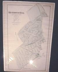
Beers Atlas
Original Map of Richmond Hill Long Island
New York: Beers 1873. Original Hand-colored Map of Richmond Hill from Beers' Atlas of Long Island 15 1/2" x 23 " approximate size; light edge-wear; age-toned old fold-lines some off-setting; very good condition. Very Good. Illus. by Beers. Beers unknown
Riferimento per il libraio : 11575
|
|
|
Beers Atlas
Original Map of Jamaica Village Long Island
New York: Beers 1873. Original Hand-colored Map of Jamaica Village from Beers' Atlas of Long Island 18 1/2" x 23 " approximate size; somewhat age-toned old fold-lines; very good condition. Very Good. Illus. by Beers. Beers unknown books
Riferimento per il libraio : 8956
|
|
|
Beers Atlas
Original Map of Part of College Point Town of Flushing Northern Part Long Island
New York: Beers 1873. Original Hand-colored Map of Part of College Point Town of Flushing Northern Part from Beers' Atlas of Long Island 15 1/2" x 23 " approximate size; somewhat age-toned; very good condition. Very Good. Illus. by Beers. Beers unknown books
Riferimento per il libraio : 8947
|
|
|
Beers Atlas
Original Map of Part of Flushing With Flushing Creek Long Island
New York: Beers 1873. Original Hand-colored Map of Part of Flushing with Flushing Creek from Beers' Atlas of Long Island three section folding 15 1/2" x 32 " approximate size; somewhat age-toned; very good condition. Very Good. Illus. by Beers. Beers unknown books
Riferimento per il libraio : 8949
|
|
|
Beers Atlas
Original Map of Part of Whitestone Village Northern Part Long Island
New York: Beers 1873. Original Hand-colored Map of Part of Whitestone Village Northern Part from Beers' Atlas of Long Island three section folding 15 1/2" x 30 " approximate size; somewhat age-toned; very good condition. Very Good. Illus. by Beers. Beers unknown books
Riferimento per il libraio : 8952
|
|
|
Beers Atlas
Original Map of Richmond Hill Long Island
New York: Beers 1873. Original Hand-colored Map of Richmond Hill from Beers' Atlas of Long Island 15 1/2" x 23 " approximate size; light edge-wear; age-toned old fold-lines some off-setting; very good condition. Very Good. Illus. by Beers. Beers unknown books
Riferimento per il libraio : 11575
|
|
|
Bej Asim K. Editor/ Aislabie Jackie Editor/ Atlas Ronald M. Editor
Polar Microbiology: The Ecology Biodiversity and Bioremediation Potential of Microorganisms in Extremely Cold Environments
CRC Pr I Llc 2019. Paperback. New. 424 pages. 9.00x6.00x1.00 inches. CRC Pr I Llc paperback
Riferimento per il libraio : __0367384590 ISBN : 0367384590 9780367384593
|
|
|
Bej Asim K. Editor/ Aislabie Jackie Editor/ Atlas Ronald M. Editor
Polar Microbiology: The Ecology Biodiversity and Bioremediation Potential of Microorganisms in Extremely Cold Environments
CRC Pr I Llc 2009. Hardcover. New. 1st edition. 424 pages. 9.65x6.50x1.06 inches. CRC Pr I Llc hardcover
Riferimento per il libraio : __1420083848 ISBN : 1420083848 9781420083842

|
|
|
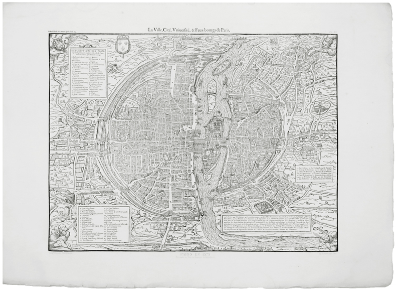
BELLEFOREST (François de) & ATLAS des ANCIENS PLANS de PARIS.
La ville, cité, université, & faux-bourgs de Paris.
[Paris, Imprimerie Nationale, 1575-1880]. 421 x 539 mm.
Riferimento per il libraio : LBW-6776
|
|
|
BELLIN
Essai géographique sur les Isles Britanniques, contenant une description de l'Angleterre, l'Ecosse et l'Irlande, tant pour la navigation des costes que pour la connoissance de l'intérieur du Pais [...].
Paris, Imprimerie Didot, 1757. In-4, (6)-471-(1) pp., reliure de l'époque plein veau brun, dos orné, tranches rouges (reliure frottée, coiffe inf. arasée; intérieur très frais).
Riferimento per il libraio : 9508

|
|
|
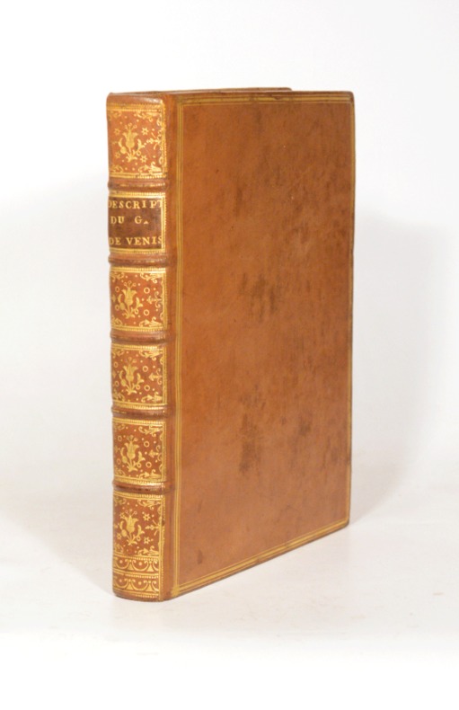
BELLIN (Jacques-Nicolas).
DESCRIPTION GÉOGRAPHIQUE DU GOLFE DE VENISE ET DE LA MORÉE. Avec des Remarques pour la Navigation, et des Cartes et Plans des Côtes, Villes, Ports et Mouillages.
1771 Paris, Imprimerie Didot, 1771. In-quarto (204 X 255 mm) veau blond, plats ornés d'un encadrement de triple filet doré, dos cinq nerfs filetés, caissons dorés ornés aux petits fers avec fleuron central, roulettes en queue, pièce de titre maroquin marron, coupes et coiffes filetées, bordure intérieure, tranches rouges (reliure de l'époque) ; (1) f. blanc, XII-235 pages, 49 planches hors-texte, (1) f. blanc.
Riferimento per il libraio : 004496
|
|
|
Bellin (N.)
Le PAYS DES HOTTENTOTS aux environs du Cap de Bonne Espérance.
français Sans date (vers 1760). Carte dépliante (247x350 mm). "Cette carte est dressée sur celles de Kolbe et sur quelques manuscrits du depost des plans de la Marine". Exemplaire sur papier fort, bien conservé.
|
|
|
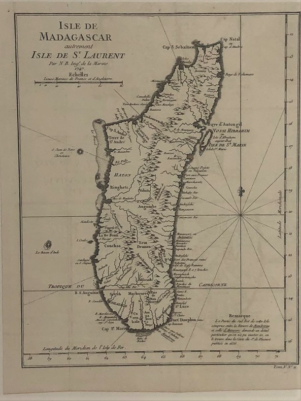
BELLIN Jacques Nicolas
Carte de Madagascar autrement isle de st.Laurent par N.B. ingénieur de la marine 1747
Carte de Madagascar autrement isle de st.Laurent par N.B. ingénieur de la marine 1747,(vers 1782). 28,5 x 22,5 cm.
Riferimento per il libraio : PHO-426
|
|
|
Bellin Jacques Nicolas
Plan de Jedo - Partie du Golphe de Jedo - Tokyo, Japon - Originale de 1752
Non renseigné. 1752. In-4. En feuillets. Etat d'usage, Couv. convenable, Dos satisfaisant, Quelques rousseurs. Plan de Jedo en noir et blanc, planche seule, 32 x 32 cm environs. Partie du Golphe de Jedo, avec le Palais de l'Empereur, Niponbas ou le pont du Japon. Echelle d'une lieue ou 2500 toises. Plan gravé par Dheulland.. . . . Classification Dewey : 912-Atlas, cartes et plans
Riferimento per il libraio : R300272026

|
|
|
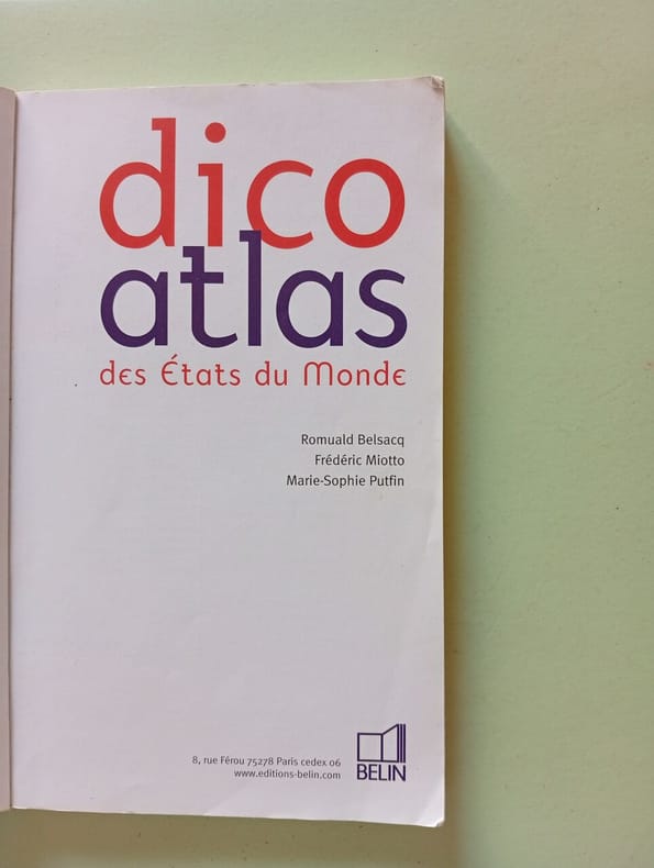
Belsacq Romuald Miotto Frédéric Putfin Marie-Sophie
Dico atlas des Etats du monde
Belin 2006 159 pages 20x12x1cm. 2006. Broché. 159 pages.
Riferimento per il libraio : 500231121
|
|
|
BELZACQ / MIOTTO / PUFIN
GRAND ATLAS MONDIAL
***. non daté. In-8. Broché. Bon état, Couv. convenable, Dos satisfaisant, Intérieur frais. 54 pages de cartes en couleurs.. . . . Classification Dewey : 912-Atlas, cartes et plans
Riferimento per il libraio : RO20133540

|
|
|
BELZACQ / MIOTTO / PUTFIN.
MICRO ATLAS GISSEROT
GISSEROT JEAN-PAUL. 2003. In-12. Broché. Bon état, Couv. convenable, Dos satisfaisant, Intérieur frais. 64 pages augmentées de nombreuses cartes couleur dans et hors texte.. . . . Classification Dewey : 912-Atlas, cartes et plans
Riferimento per il libraio : R320097386
|
|
|
BELZACQ / MIOTTO / PUTFIN.
MICRO ATLAS GISSEROT
ISBN : 2877477037. GISSEROT JEAN-PAUL. 2003. In-12 Carré. Broché. Bon état. Couv. convenable. Dos satisfaisant. Intérieur frais. 64 pages augmentées de nombreuses cartes couleur dans et hors texte.
|
|
|
Bemmelen (W. van), Dr.
JAVA. Regenatlas (rainfall-atlas). Uitkomsten der Regenwaarnemingen op Java / Results of Rainfall-observations in Java.
anglais In-plano (61x40 cm.) non paginé de 20 pp.; broché, couverture imprimée, second plat remplié. Uitgegeven in opdracht van het gouvernement van nederlandsch-indië / published by order of the government of netherlands India. Cartes en couleurs. Peu courant.
|
|
|
Benati Gianfranco
Atlas des merveilles du monde
Comptoir du livre. 1990. In-Folio. Cartonné. Bon état, Couv. convenable, Dos satisfaisant, Intérieur frais. 60 pages. Nombreuses photos et cartes en couleurs, dans et hors texte. Frontispice illustré d'une photos en couleurs.. . . . Classification Dewey : 912-Atlas, cartes et plans
Riferimento per il libraio : RO30328832
|
|
|
BENATI GIANFRANCO
ATLAS DES MERVEILLES.
FRANCE LOISIRS / FERNAND NATHAN. 1979. In-4. Relié. Bon état, Couv. convenable, Dos satisfaisant, Intérieur frais. 60 pages. Nombreuses cartes et photographies en couleur dans le format texte.. . . . Classification Dewey : 912-Atlas, cartes et plans
Riferimento per il libraio : R240047336
|
|
|
Benati Gianfranco
Atlas des merveilles.
Fernand Nathan. 1979. In-4. Relié. Etat d'usage, Coins frottés, Coiffe en pied abîmée, Intérieur acceptable. 60 pages - nombreuses photos et cartes en couleurs dans et hors texte - quelques pages désolidarisées - coins frottés - coiffes abîmées.. . . . Classification Dewey : 912-Atlas, cartes et plans
Riferimento per il libraio : R320149430 ISBN : 2092900188

|
|
|
BENATI Gianfranco
Atlas des merveilleux.
FRANCE LOISIRS. 1975. In-4. Cartonné. Parfait état, Couv. fraîche, Dos satisfaisant, Intérieur frais. 60 pages. Frontispice en couleurs, hors-texte. Nombreuses photos en couleurs dans le texte et en planches hors-texte.. . . . Classification Dewey : 912-Atlas, cartes et plans
Riferimento per il libraio : RO20051496
|
|
|
Bengtson, Hermann Dr
Grosser historischer Weltatlas; erster Teil : Vorgeschichte und Altertum.
München : Bayerischer Schulbuch-Verl., 1972. 5., durchges. Aufl. [97] S. in getr. Zählung : überw. Kt., graph. Darst.; 35 cm Hlw.
Riferimento per il libraio : 27906 ISBN : 376276005
|
|
|
BENISA, Melchioris:
Descriptio Geographica et Statistica provinciarum et missionum ordinis fratrum minorum S. Francisci Capuccinorum in XXXVIII tabulius quarto jam pleno saeculo ab ordine condito (1528-1928) edita jussu Ministri Generalis R. MI P. Melchioris A Benisa.
Romae, Apud Curiam Generalem , 1929, in-4to, 76 p. + 2 ff. + 38 cartes en couleur + XXX, reliure en toile originale.
Riferimento per il libraio : 128893aaf
|
|
|
Benjaminse paul
Onegrensd fietsen door Toscane en Umbtië naar Rome Amsterdam Rome deel 3 5è druk
Benjaminse Uitgeverij. non daté. In-8. Relié. Très bon état, Couv. convenable, Dos satisfaisant, Intérieur frais. 141 pages augmentées de quelques plans géographiques en couleurs dans texte. Reliure spirale.. . . . Classification Dewey : 912-Atlas, cartes et plans
Riferimento per il libraio : R260271769

|
|
|
Benner, Klaus-Ulrich und Sascha Wuillemet
Der große medizinische Atlas des Menschen. Klaus-U. Benner ; Sascha Wuillemet
Wien : Tosa 2007. 352 S. : durchg. farb. ; 33 cm Pp., gebundene Ausgabe, Hardcover/Pappeinband, Exemplar in gutem Erhaltungszustand
Riferimento per il libraio : 56070

|
|
|
Beresford, Dr. A. K. C. and H. W. Dobson (Editors)
Lloyd's Maritime Atlas of World Ports and Shipping Places
Lloyd's of London Press, Colchester [a.o.], 1989. IV, 145 S. ; 30,5 x 21,5 cm ; Pp. ;
Riferimento per il libraio : 131733

|
|
|
Berg, A. (Dr.)
Universal-Atlas und illustriertes geographisches Handbuch
Leipzig: Verlag für allgemeines Wissen. um 1905. 50 farb. Karten. 38 S. Text. 36x41cm 1. Auflage Halbleder, der ehemals dekorative Jugendstileinband illustriert, jetzt sehr stark berieben, Rücken fest geklebt, Kanten etwas bestoßen, kl. Eintragung am Titelblatt, min. Einriss rechts am Titel, etwas fingerfleckige Seite, Kartentafeln gut (Zustand im Pr
Riferimento per il libraio : 19293
|
|
|
BERGELIN
Carte de la Mer Baltique et des Pays Scandinaves.
LECONTE A.. Non daté. In-Plano. En feuillets. Bon état, Couv. convenable, Dos satisfaisant, Intérieur frais. Carte dépliante en couleurs, de 100/75 cm, hors-texte. Pas de plats de couverture.. . . . Classification Dewey : 912-Atlas, cartes et plans
Riferimento per il libraio : RO80010824
|
|
|
BERGELIN (PEUGEOT)
ATLAS ROUTIER PEUGEOT. CARTE DE LA FRANCE 9 PLANCHES, échelle 1/1 000 000
Sans lieu, ni date, environ 1950. In-4 cartonné, reliure spirale, 25 pages environ. Imprimé et crée par Draeger, Bergelin géographe.Bords frottés à 3 endroits, sinon bel exemplaire.
Riferimento per il libraio : 5974
|
|
|
BERGELIN (PEUGEOT)
ATLAS ROUTIER PEUGEOT. CARTE DE LA FRANCE 9 PLANCHES, échelle 1/1 000 000
Sans lieu, ni date, environ 1950. In-4 cartonné, reliure spirale, 25 pages environ. Imprimé et crée par Draeger, Bergelin géographe. Bords frottés à 3 endroits, sinon bel exemplaire.
|
|
|
BERGET ALPHONSE
"L'AIR / ""UNE NOUVELLE CONQUETE DE L'HOMME""."
LIBRAIRIE LAROUSSE. 1927. In-4. Relié. Bon état, Couv. convenable, Dos satisfaisant, Intérieur frais. 310 pages augmentées de nombreuses illustrations en noir et blanc dans le texte et des illustrations en couleur hors texte - Tranches bordeaux.. . . . Classification Dewey : 912-Atlas, cartes et plans
Riferimento per il libraio : R320097856
|
|
|
BERGET ALPHONSE
L'AIR / "UNE NOUVELLE CONQUETE DE L'HOMME".
LIBRAIRIE LAROUSSE. 1927. In-4 Carré. Relié. Bon état. Couv. convenable. Dos satisfaisant. Intérieur frais. 310 pages augmentées de nombreuses illustrations en noir et blanc dans le texte et des illustrations en couleur hors texte - Tranches bordeaux. 700 REPRODUCTIONS PHOTOGRAPHIQUES .276 CARTES OU DESSINS .8 CARTES HORS TEXTE .9 HORS TEXTE EN COULEURS 20 HELIOGRAVURES
|
|
|
Berghaus, Dr. Heinrich
Dr. Heinrich Berghaus' Physikalischer Schul-Atlas. Bestehend aus acht und zwanzig in Kupfer gestochenen und colorirten Karten. Ein Auszug aus des Verfassers großem physikalischen Atlas. Zum Gebrauch beim Unterricht und zum Selbststudium [Faksimile-Ausgabe]
Braunschweig: Archiv Verlag, 2000. 12 S., 28 Bl. ; 32,5 x 25 cm quer ;
Riferimento per il libraio : 132071

|
|
|
Berghaus, Heinrich (Kartograf)
Physikalischer Schul-Atlas. Heinrich Berghaus
Gotha : VEB Hermann Haack 1985. 1. Reprintaufl. [d. Ausg.] 1850 12 S., 28 Doppelblatt-Karten ; 25 cm Leinen 0
Riferimento per il libraio : 79434

|
|
|
Bergstrom, Ola; Moberg, Oskar
Bergvalls Skolatlas (Skol Atlas), Del I-II, I Ett Band.
32 pages. Colour maps throughout. Above-average but not excessive wear. Binding intact. Prior owner's name atop page 1. Some pencil markings and writing to contents. A worthy copy of this vintage Swedish school atlas. Book

|
|
|
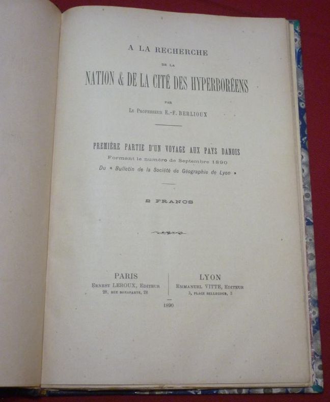
BERLIOUX, Étienne-Félix
A La Recherche de la Nation & de la Cité des Hyperboréens par le Professeur E.-F. Berlioux. Première Partie d'un Voyage aux Pays Danois formant le numéro de Septembre 1890 du "Bulletin de la Société de Géographie de Lyon".
Paris, Ernest Leroux Editeur / Lyon, Emmanuel Vitte, Editeur, 1890, 1 volume in-8 de 255x165 mm environ, 92 pages, demi-basane bleu marine, dos à nerfs portant titres dorés sur pièce de titre bordeaux, gardes marbrées. Bon état.
Riferimento per il libraio : 100216
|
|
|
Berlitz Publishing Staff; Hammonds World Atlas Corporate Staff
Spanish - Berlitz Compact Dictionary : Spanish-English Ingles-Espanol
APA Publications Services 2009. Paperback. Good. Disclaimer:A copy that has been read but remains in clean condition. All pages are intact and the cover is intact. The spine may show signs of wear. Pages can include limited notes and highlighting and the copy can include previous owner inscriptions. At ThriftBooks our motto is: Read More Spend Less.Dust jacket quality is not guaranteed. APA Publications Services paperback
Riferimento per il libraio : G9812686487I3N00 ISBN : 9812686487 9789812686480
|
|
 Ricevere i risultati per e-mail
 Scaricare i risultati in PDF
 RSS feed


