|
CARTES TARIDE
CARTE ROUTIERE N°19 - LANGUEDOC (OUEST), CAUSSES
EDITIONS TARIDE. Non daté. In-Plano. Broché. Etat d'usage, Couv. légèrement passée, Dos satisfaisant, Intérieur acceptable. Carte dépliante en couleurs en 16 volets en couleurs au 1/250.000e. Note au stylo au dos de la carte.. . . . Classification Dewey : 912-Atlas, cartes et plans
書籍販売業者の参照番号
: RO70122789
|
|
|
CARTES TARIDE
CARTE ROUTIERE N°2BIS - LORRAINE ET ALSACE ( NORD)
EDITIONS TARIDE. Non daté. In-Plano. Broché. Etat d'usage, Couv. légèrement passée, Dos satisfaisant, Intérieur acceptable. Carte dépliante en couleurs en 16 volets en couleurs au 1/250.000e.. . . . Classification Dewey : 912-Atlas, cartes et plans
書籍販売業者の参照番号
: RO70122790
|
|
|
CARTES TARIDE
CARTE ROUTIERE N°16 - BORDELAIS - ANGOUMOIS (SUD OUEST)
EDITIONS TARIDE. Non daté. In-Plano. Broché. Etat d'usage, Couv. légèrement passée, Dos satisfaisant, Intérieur acceptable. Carte dépliante en couleurs en 32 volets en couleurs au 1/250.000e.. . . . Classification Dewey : 912-Atlas, cartes et plans
書籍販売業者の参照番号
: RO70122791
|
|
|
CARTES TARIDE
CARTE DE LA RUSSIE
EDITIONS TARIDE. Non daté. In-Plano. Broché. Etat d'usage, Couv. légèrement passée, Dos satisfaisant, Intérieur acceptable. Carte dépliante en couleurs en 16 volets en couleurs au 1/4.000.000e.. . . . Classification Dewey : 912-Atlas, cartes et plans
書籍販売業者の参照番号
: RO70122792
|
|
|
CARTES TARIDE
CARTE ROUTIERE N°15 - AUVERGNE, LIMOUSIN
EDITIONS TARIDE. Non daté. In-Plano. Broché. Etat d'usage, Couv. légèrement passée, Dos satisfaisant, Intérieur acceptable. Carte dépliante en couleurs en 32 volets en couleurs au 1/250.000e. Note au stylo au dos de la carte.. . . . Classification Dewey : 912-Atlas, cartes et plans
書籍販売業者の参照番号
: RO70122793
|
|
|
CARTES TARIDE
CARTE ROUTIERE N°13 - VENDEE
EDITIONS TARIDE. Non daté. In-Plano. Broché. Etat passable, Couv. légèrement passée, Dos satisfaisant, Intérieur acceptable. Carte dépliante en couleurs en 20 volets en couleurs. Coté droit et bas de carte coupée altérant la lecture de la carte. Note au stylo au dos de la carte.. . . . Classification Dewey : 912-Atlas, cartes et plans
書籍販売業者の参照番号
: RO70122794
|
|
|
CARTES TARIDE
CARTE N°17 FRONTIERE ITALIE FRANCE
EDITIONS TARIDE. Non daté. In-Plano. Broché. Etat d'usage, Couv. légèrement passée, Dos satisfaisant, Intérieur acceptable. Carte dépliante en couleurs en 34 volets en couleurs.. . . . Classification Dewey : 912-Atlas, cartes et plans
書籍販売業者の参照番号
: RO70122795
|
|
|
CARTES TARIDE
CARTE ROUTIERE N°20 - GARONNE, LANDES
EDITIONS TARIDE. Non daté. In-Plano. Broché. Etat d'usage, Couv. légèrement passée, Dos satisfaisant, Intérieur acceptable. Carte dépliante en couleurs en 32 volets en couleurs au 1/250.000e. Quelques trous aux intersections de la carte altérant légèrement la lecture.. . . . Classification Dewey : 912-Atlas, cartes et plans
書籍販売業者の参照番号
: RO70122797
|
|
|
CARTES TARIDE
CARTE CYCLISTES DU SUD OUEST DE LA FRANCE - BORDEAUX A TOULOUSE
EDITIONS TARIDE. Non daté. In-Plano. Broché. Etat d'usage, Couv. légèrement passée, Dos satisfaisant, Intérieur acceptable. Carte dépliante en couleurs en 32 volets, en couleurs au 1/250.000e. Trous sur le coté gauche de la carte altérant la lecture.. . . . Classification Dewey : 912-Atlas, cartes et plans
書籍販売業者の参照番号
: RO70122801
|
|
|
CARTES TARIDE
CARTE D'EUROPE
EDITIONS TARIDE. Non daté. In-Plano. Broché. Etat d'usage, Couv. légèrement passée, Dos satisfaisant, Intérieur acceptable. Carte dépliante en couleurs en 24 volets en couleurs au 1/4.200.000e.. . . . Classification Dewey : 912-Atlas, cartes et plans
書籍販売業者の参照番号
: RO70122808
|
|
|
CARTES TARIDE
CARTE ROUTIERE REGIONALES N°3 DE PARIS 200KM NORD EST- CARTE COMPLETE POUR LE TOURISME
EDITIONS TARIDE. Non daté. In-Plano. Broché. Etat d'usage, Couv. légèrement passée, Dos satisfaisant, Intérieur acceptable. Carte dépliante en 27 volets, en couleurs au 1/250.000e.. . . . Classification Dewey : 912-Atlas, cartes et plans
書籍販売業者の参照番号
: RO70122503
|
|
|
CARTES TARIDE
CARTE ROUTIERE REGIONALES N°11 DE BOURGOGNE MORVAN NIVERNAIS BOURBONNAIS - CARTE COMPLETE POUR LE TOURISME
EDITIONS TARIDE. Non daté. In-Plano. Broché. Etat d'usage, Couv. légèrement passée, Dos satisfaisant, Intérieur acceptable. Carte dépliante en 27 volets, en couleurs au 1/250.000e.. . . . Classification Dewey : 912-Atlas, cartes et plans
書籍販売業者の参照番号
: RO70122504
|
|
|
CARTES TARIDE
CARTE ROUTIERE REGIONALES N°20 GARONNE LANDES (VALLE DE LA GARONNE, DE BORDEAUX A TOULOUSE - CARTE COMPLETE POUR LE TOURISME
EDITIONS TARIDE. Non daté. In-Plano. Broché. Etat d'usage, Couv. légèrement passée, Dos satisfaisant, Intérieur acceptable. Carte dépliante en 27 volets, en couleurs au 1/250.000e. Couverture abîmée.. . . . Classification Dewey : 912-Atlas, cartes et plans
書籍販売業者の参照番号
: RO70122505
|
|
|
CARTES TARIDE
CARTE ENTOILEE DES ENVIRONS DE PARIS NORD EST POUR CYCLISTES ET AUTOMOBILISTES N°3
EDITIONS TARIDE. Début XXe. In-Plano. Relié toilé. Etat d'usage, Couv. légèrement passée, Dos satisfaisant, Intérieur acceptable. Carte dépliante entoilée en noir et blanc et rouge en 32 volets, en couleurs au 1/100.000e.. . . . Classification Dewey : 912-Atlas, cartes et plans
書籍販売業者の参照番号
: RO70122515
|
|
|
CARTES TARIDE
CARTE ENTOILEE DES ENVIRONS DE PARIS SUD OUEST POUR CYCLISTES ET AUTOMOBILISTES N°8
EDITIONS TARIDE. Début XXe. In-Plano. Relié toilé. Etat d'usage, Couv. légèrement passée, Dos satisfaisant, Intérieur acceptable. Carte dépliante entoilée en couleurs ( noir, blanc, rouge, vert) en 32 volets, en couleurs au 1/100.000e.. . . . Classification Dewey : 912-Atlas, cartes et plans
書籍販売業者の参照番号
: RO70122516
|
|
|
CARTES TARIDE
CARTE ENTOILEE DE LA BRETAGNE SECTION SUD POUR CYCLISTES ET AUTOMOBILISTES N°9
EDITIONS TARIDE. Début XXe. In-Plano. Relié toilé. Etat d'usage, Couv. légèrement passée, Dos satisfaisant, Intérieur acceptable. Carte dépliante entoilée en couleurs ( noir, blanc, rouge, vert, bleu) en 32 volets, en couleurs au 1/100.000e.. . . . Classification Dewey : 912-Atlas, cartes et plans
書籍販売業者の参照番号
: RO70122517
|
|
|
CARTES TARIDE
CARTE ENTOILEE DU CENTRE DE LA FRANCE SECTION SUD OUEST POUR CYCLISTES ET AUTOMOBILISTES N°16
EDITIONS TARIDE. Début XXe. In-Plano. Relié toilé. Etat d'usage, Couv. légèrement passée, Dos satisfaisant, Intérieur acceptable. Carte dépliante entoilée en couleurs ( noir, blanc, rouge, vert, bleu) en 32 volets, en couleurs au 1/100.000e.. . . . Classification Dewey : 912-Atlas, cartes et plans
書籍販売業者の参照番号
: RO70122518
|
|
|
CARTES TARIDE
CARTE ENTOILEE DE L'ESPAGNE PORTUGAL POUR CYCLISTES ET AUTOMOBILISTES N°34
EDITIONS TARIDE. Début XXe. In-Plano. Relié toilé. Etat d'usage, Couv. légèrement passée, Dos satisfaisant, Intérieur acceptable. Carte dépliante entoilée en couleurs ( noir, blanc, rouge, vert, bleu) en 32 volets, en couleurs au 1/100.000e.. . . . Classification Dewey : 912-Atlas, cartes et plans
書籍販売業者の参照番号
: RO70122519
|
|
|
CARTES TARIDE
CARTE ENTOILEE DE L'ALLEMAGNE DU NORD POUR CYCLISTES ET AUTOMOBILISTES N°36
EDITIONS TARIDE. Début XXe. In-Plano. Relié toilé. Etat d'usage, Couv. légèrement passée, Dos satisfaisant, Intérieur acceptable. Carte dépliante entoilée en couleurs ( noir, blanc, rouge) en 32 volets, en couleurs au 1/100.000e.. . . . Classification Dewey : 912-Atlas, cartes et plans
書籍販売業者の参照番号
: RO70122520
|
|
|
CARTES TARIDE
CARTE ENTOILEE DES ENVIRONS DE PARIS 80 KILOMETRES SUD OUEST POUR CYCLISTES ET AUTOMOBILISTES
EDITIONS TARIDE. Début XXe. In-Plano. Relié toilé. Etat d'usage, Couv. légèrement passée, Dos satisfaisant, Intérieur acceptable. Carte dépliante entoilée en couleurs ( noir, blanc, rouge, vert, bleu) en 32 volets, en couleurs au 1/100.000e.. . . . Classification Dewey : 912-Atlas, cartes et plans
書籍販売業者の参照番号
: RO70122521
|
|
|
CARTES TARIDE
CARTE ROUTIERE BORDELAIS, ANGOUMOIS N°16
EDITIONS TARIDE. Non daté. In-Plano. Broché. Etat d'usage, Couv. légèrement passée, Dos satisfaisant, Intérieur acceptable. Carte dépliante en couleurs en 30 volets, en couleurs au 1/250.000e dans une pochette.. . . . Classification Dewey : 912-Atlas, cartes et plans
書籍販売業者の参照番号
: RO70122536
|
|
|
CARTES TARIDE
CARTE MICHELIN AURILLAC CAHORS N°35
EDITIONS TARIDE. Non daté. In-Plano. Broché. Etat d'usage, Couv. légèrement passée, Dos satisfaisant, Intérieur acceptable. Carte dépliante en couleurs en 20 volets, en couleurs au 1/250.000e.. . . . Classification Dewey : 912-Atlas, cartes et plans
書籍販売業者の参照番号
: RO70122540
|
|
|
CARTES TARIDE
CARTE DES ENVIRONS DE PARIS 50 KILOMETRES
EDITIONS TARIDE. Non daté. In-Plano. Broché. Etat d'usage, Couv. légèrement passée, Dos satisfaisant, Intérieur acceptable. Carte dépliante en couleurs en 36 volets, en couleurs au 1/100.000e.. . . . Classification Dewey : 912-Atlas, cartes et plans
書籍販売業者の参照番号
: RO70122542
|
|
|
CARTES TARIDE
CARTE ROUTIERE DE LA FORET DE FONTAINEBLEAU AVEC PLAN DE VILLE
EDITIONS TARIDE. Non daté. In-Plano. Broché. Etat d'usage, Couv. légèrement passée, Dos satisfaisant, Intérieur acceptable. Carte dépliante en couleurs en 16 volets, en couleurs au 1/57.000e.. . . . Classification Dewey : 912-Atlas, cartes et plans
書籍販売業者の参照番号
: RO70122545
|
|
|
CARTE Taride
Carte Routière N°16 - Bordelais, Angoumois (Sud-Ouest)
Taride. Non daté. In-8. Broché. Bon état, Couv. convenable, Dos satisfaisant, Déchirures. Carte en couleurs de 1,20/1 m., déchirures sur les pliures - Avec son étui papier en mauvais état. . . . Classification Dewey : 912-Atlas, cartes et plans
書籍販売業者の参照番号
: ROD0006983
|
|
|
Cartes Taride
Carte routière n°8 : Paris - Orléanais
Taride. Non daté. In-Plano. En feuillets. Bon état, Couv. convenable, Dos satisfaisant, Intérieur frais. Carte routière couleur entoilée. format 85 x 100.. . . . Classification Dewey : 912-Atlas, cartes et plans
書籍販売業者の参照番号
: ROD0042698
|
|
|
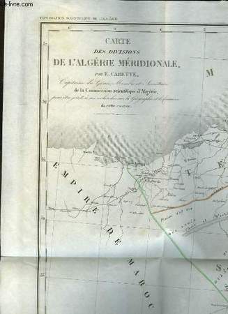
CARETTE et RENOU
Carte orographique de l'Algérie - Carte d'une partie de l'Afrique Septentrionale - Carte des Divisions de l'Algérie Méridionale.
FORTIN, MASSON & Cie. 1844. In-Plano. En feuillets. Très bon état, Couv. convenable, Dos satisfaisant, Intérieur frais. 3 cartes dépliantes, une en noir et blanc et deux en couleurs. Cartes rangées dans une chemise cartonnée et rempliée. Carte de l'Algérie, 75/48 cm, échelle de 1/2000000. Carte d'Afrique Septentrionale (en couleurs), 46 / 47 cm, échelle de 1 / 10 000 000. Carte d'Algérie Méridionale (en couleurs) de 48 / 75 cm, échelle de 1 / 2 000 000.. . . . Classification Dewey : 912-Atlas, cartes et plans
書籍販売業者の参照番号
: RO80068273
|
|
|
CARTES TARIDE
CARTE ENTOILEE DE BRIANCON FEUILLET N°6
EDITIONS TARIDE. 1886. In-Plano. Relié toilé. Etat d'usage, Couv. légèrement passée, Dos satisfaisant, Intérieur acceptable. Carte dépliante entoilée en noir et blanc en 9 volets au 1/320.000e. Etiquette de bibliothèque sur le 1er plat.. . . . Classification Dewey : 912-Atlas, cartes et plans
書籍販売業者の参照番号
: RO70122686
|
|
|
CARTES TARIDE
CARTE ENTOILEE D'AVIGNON FEUILLET N°7
EDITIONS TARIDE. 1886. In-Plano. Relié toilé. Etat d'usage, Couv. légèrement passée, Dos satisfaisant, Intérieur acceptable. Carte dépliante entoilée en noir et blanc en 9 volets au 1/320.000e. Note au stylo rouge sur le bas de la carte. Etiquette de bibliothèque sur le 1er plat.. . . . Classification Dewey : 912-Atlas, cartes et plans
書籍販売業者の参照番号
: RO70122685
|
|
|
CARTES TARIDE
CARTE ENTOILEE DE LA FRANCE ROUTIERE ET KILOMETRIQUES INDIQUANT LES GRANDS ITINERAIRES POUR CYCLISTES ET AUTOMOBILISTES
EDITIONS TARIDE. Début XXe. In-Plano. Relié toilé. Etat d'usage, Couv. partiel. décollorée, Dos satisfaisant, Pliures. Carte dépliante entoilée en noir et blanc en 32 volets, en couleurs au 1/300.000e. Note au stylo sur le titre n'altérant pas la lecture.. . . . Classification Dewey : 912-Atlas, cartes et plans
書籍販売業者の参照番号
: RO70122682
|
|
|
CARTES TARIDE
CARTE ROUTIERE DE LA TOURAINE, BERRY N°12
EDITIONS TARIDE. Non daté. In-Plano. Broché. Etat d'usage, Couv. légèrement passée, Dos satisfaisant, Intérieur acceptable. Carte dépliante en couleurs en 30 volets, en couleurs au 1/250.000e dans une pochette usée.. . . . Classification Dewey : 912-Atlas, cartes et plans
書籍販売業者の参照番号
: RO70122768
|
|
|
CARTES TARIDE
CARTE ENTOILEE DE MARSEILLE FEUILLET N°9
EDITIONS TARIDE. 1886. In-Plano. Relié toilé. Etat d'usage, Couv. légèrement passée, Dos satisfaisant, Intérieur acceptable. Carte dépliante entoilée en noir et blanc en 9 volets au 1/320.000e. Etiquette de bibliothèque sur le 1er plat.. . . . Classification Dewey : 912-Atlas, cartes et plans
書籍販売業者の参照番号
: RO70122687
|
|
|
CARTES TARIDE
CARTE ROUTIERE DES ENVIRONS DE PARIS SECTION NORD EST A L'USAGE DES CYCLISTES ET AUTOMOBILISTES N°3
EDITIONS TARIDE. Non daté. In-Plano. Broché. Etat d'usage, Couv. légèrement passée, Dos satisfaisant, Intérieur acceptable. Carte dépliante en couleurs en 32 volets, en couleurs au 1/250.000e dans une pochette très usée.. . . . Classification Dewey : 912-Atlas, cartes et plans
書籍販売業者の参照番号
: RO70122699
|
|
|
CARTES TARIDE
CARTE N°4 DE PARIS 200 KM NORD OUEST- CARTE COMPLETE POUR LE TOURISME
EDITIONS TARIDE. Non daté. In-Plano. Broché. Etat d'usage, Couv. légèrement passée, Dos satisfaisant, Rousseurs. Carte dépliante en 27 volets, en couleurs au 1/250.000e.. . . . Classification Dewey : 912-Atlas, cartes et plans
書籍販売業者の参照番号
: RO70122689
|
|
|
CARTES TARIDE
CARTE N°29 DE TOUTE LA SUISSE EN 1 FEUILLE- CARTE COMPLETE POUR LE TOURISME
EDITIONS TARIDE. Non daté. In-Plano. Broché. Etat d'usage, Couv. légèrement passée, Dos satisfaisant, Intérieur acceptable. Carte dépliante en 24 volets, en couleurs au 1/400.000e. Etiquette de bibliothèque sur le 1er plat.. . . . Classification Dewey : 912-Atlas, cartes et plans
書籍販売業者の参照番号
: RO70122692
|
|
|
CARTES TARIDE
CARTE ROUTIERE NORD DE LA FRANCE ET BELGIQUE A L'USAGE DES CYCLISTES ET AUTOMOBILISTES N°1
EDITIONS TARIDE. Non daté. In-Plano. Broché. Etat d'usage, Couv. légèrement passée, Dos satisfaisant, Intérieur acceptable. Carte dépliante en couleurs en 32 volets, en couleurs au 1/250.000e dans une pochette.. . . . Classification Dewey : 912-Atlas, cartes et plans
書籍販売業者の参照番号
: RO70122696
|
|
|
CARTES TARIDE
CARTE N°38 DE TOUTE LA BELGIQUE EN 1 FEUILLE- CARTE COMPLETE POUR LE TOURISME
EDITIONS TARIDE. Non daté. In-Plano. Broché. Etat d'usage, Couv. légèrement passée, Dos satisfaisant, Intérieur acceptable. Carte dépliante en 48 volets, en couleurs au 1/250.000e. Note au stylo rouge sur le 1er plat et au stylo bleu sur le second plat.. . . . Classification Dewey : 912-Atlas, cartes et plans
書籍販売業者の参照番号
: RO70122691
|
|
|
CARTES TARIDE
CARTE ROUTIERE POUR AUTOMOBILISTES CENTRE DE LA FRANCE - AUVERGNE N°15
EDITIONS TARIDE. Non daté. In-Plano. Broché. Etat d'usage, Couv. légèrement passée, Dos satisfaisant, Intérieur acceptable. Carte dépliante en couleurs en 32 volets en couleurs au 1/250.000e dans une pochette usée. Note au crayon sur le dos de la carte et sur la pochette.. . . . Classification Dewey : 912-Atlas, cartes et plans
書籍販売業者の参照番号
: RO70122706
|
|
|
CARTES TARIDE
CARTE ROUTIERE POUR AUTOMOBILISTES EST DE LA FRANCE N°6
EDITIONS TARIDE. Non daté. In-Plano. Broché. Etat d'usage, Couv. légèrement passée, Dos satisfaisant, Intérieur acceptable. Carte dépliante en couleurs en 32 volets en couleurs au 1/250.000e dans une pochette usée.. . . . Classification Dewey : 912-Atlas, cartes et plans
書籍販売業者の参照番号
: RO70122705
|
|
|
CARTES TARIDE
CARTE ENTOILEE D'ITALIE SECTION NORD POUR CYCLISTES ET AUTOMOBILISTES N°30
EDITIONS TARIDE. Début XXe. In-Plano. Relié toilé. Etat d'usage, Couv. légèrement passée, Dos satisfaisant, Intérieur acceptable. Carte dépliante entoilée en noir et blanc et rouge en 32 volets en couleurs au 1/250.000e.. . . . Classification Dewey : 912-Atlas, cartes et plans
書籍販売業者の参照番号
: RO70122709
|
|
|
CARTES TARIDE
CARTE ROUTIERE POUR AUTOMOBILISTES SUD DE LA FRANCE SECTION CENTRALE N°18
EDITIONS TARIDE. Non daté. In-Plano. Broché. Etat d'usage, Couv. légèrement passée, Dos satisfaisant, Intérieur acceptable. Carte dépliante en couleurs en 32 volets en couleurs au 1/250.000e dans une pochette usée. Note au stylo sur la pochette.. . . . Classification Dewey : 912-Atlas, cartes et plans
書籍販売業者の参照番号
: RO70122707
|
|
|
CARTES TARIDE
CARTE ENTOILEE DE LA NORMANDUE (OUEST) ET DE LA BRETAGNE (NORD) POUR CYCLISTES ET AUTOMOBILISTES N°5
EDITIONS TARIDE. Début XXe. In-Plano. Relié toilé. Etat d'usage, Couv. légèrement passée, Dos satisfaisant, Intérieur acceptable. Carte dépliante entoilée en noir et blanc et rouge en 32 volets en couleurs au 1/250.000e.. . . . Classification Dewey : 912-Atlas, cartes et plans
書籍販売業者の参照番号
: RO70122710
|
|
|
CARTES TARIDE
CARTE ROUTIERE DE PARIS, ORLEANAIS N°8
EDITIONS TARIDE. Non daté. In-Plano. Broché. Etat d'usage, Couv. légèrement passée, Dos satisfaisant, Intérieur acceptable. Carte dépliante en couleurs en 30 volets, en couleurs au 1/250.000e .. . . . Classification Dewey : 912-Atlas, cartes et plans
書籍販売業者の参照番号
: RO70122716
|
|
|
CARTES TARIDE
CARTE ROUTIERE DE LA BOURGOGNE, NIVERNAIS N°11
EDITIONS TARIDE. Non daté. In-Plano. Broché. Etat d'usage, Couv. légèrement passée, Dos satisfaisant, Intérieur acceptable. Carte dépliante en couleurs en 30 volets, en couleurs au 1/250.000e .. . . . Classification Dewey : 912-Atlas, cartes et plans
書籍販売業者の参照番号
: RO70122718
|
|
|
CARTES TARIDE
CARTE ROUTIERE DE L'AUVERGNE, LIMOUSIN N°15
EDITIONS TARIDE. Non daté. In-Plano. Broché. Etat d'usage, Couv. légèrement passée, Dos satisfaisant, Intérieur acceptable. Carte dépliante en couleurs en 30 volets, en couleurs au 1/250.000e .. . . . Classification Dewey : 912-Atlas, cartes et plans
書籍販売業者の参照番号
: RO70122725
|
|
|
CARTES TARIDE
CARTE ROUTIERE DES PYRENEES (OUEST) N°22
EDITIONS TARIDE. Non daté. In-Plano. Broché. Etat d'usage, Couv. légèrement passée, Dos satisfaisant, Intérieur acceptable. Carte dépliante en couleurs en 30 volets, en couleurs au 1/250.000e. Note au stylo sur le 1er plat.. . . . Classification Dewey : 912-Atlas, cartes et plans
書籍販売業者の参照番号
: RO70122737
|
|
|
CARTES TARIDE
CARTE ROUTIERE DE LA GARONNE (LANDES) N°20
EDITIONS TARIDE. Non daté. In-Plano. Broché. Etat d'usage, Couv. légèrement passée, Dos satisfaisant, Intérieur acceptable. Carte dépliante en couleurs en 30 volets, en couleurs au 1/250.000e .. . . . Classification Dewey : 912-Atlas, cartes et plans
書籍販売業者の参照番号
: RO70122732
|
|
|
CARTES TARIDE
CARTE ROUTIERE N°16 - BORDELAIS, ANGOUMOIS (SUD OUEST)
EDITIONS TARIDE. Non daté. In-Plano. Broché. Etat d'usage, Couv. légèrement passée, Dos satisfaisant, Intérieur acceptable. Carte dépliante en couleurs en 32 volets en couleurs au 1/250.000e. Note au stylo en haut à gauche de la carte n'altérant pas la lecture.. . . . Classification Dewey : 912-Atlas, cartes et plans
書籍販売業者の参照番号
: RO70122767
|
|
|
CARTES TARIDE
CARTE ROUTIERE DES ENVIRONS DE PARIS 20 KIL AU 50000e (BANLIEUE)
EDITIONS TARIDE. Non daté. In-Plano. Broché. Etat d'usage, Couv. légèrement passée, Dos satisfaisant, Intérieur acceptable. Carte dépliante en couleurs en 30 volets en couleurs au 1/50.000e.. . . . Classification Dewey : 912-Atlas, cartes et plans
書籍販売業者の参照番号
: RO70122748
|
|
|
CARTES TARIDE
CARTE GUIDE DE LA FORET DE FONTAINEBLEAU AVEC PLAN DE LA VILLE
EDITIONS TARIDE. Non daté. In-Plano. Broché. Etat d'usage, Couv. légèrement passée, Dos satisfaisant, Intérieur acceptable. Carte dépliante en couleurs en 15 volets en couleurs au 1/57.000e. Quelques mouillures sur les cotes de la carte. Note au stylo sur la pochette.. . . . Classification Dewey : 912-Atlas, cartes et plans
書籍販売業者の参照番号
: RO70122746
|
|
 検索結果のメールを受信する
 PDFファイルの検索結果をダウンロード
 RSSフィード


