|
SPEED John 1552 1629
Theatre of the Empire of Great Britaine. Glamorgan Shyre With the situations of the cheife towne Cardyff and ancient Landaffe described.
London: Bassett & Chiswell 1676. Single sheet 15 x 20 inches Full margins showing the plate mark slight browning to edge This stunningly detailed uncolored edition of Glamorgen Shyre; taken from John Speed's world famous Theatre of the Empire of Great Britaine. These 17th century plates were engraved in Amsterdam by the great Dutch mapmaker Jodocus Hondius and exhibit the highest level of craftsmanship and artistic embellishment. Although an initially rural and pastoral county Glamorgen soon became defined as a land highly concentrated with castles and abbeys - demonstrated by example of Landaffe and Cardyfe in this map. The historic county stretches its borders with Carmardenshire Breknokshire and Mounmethshire. The bottom portion of the map represents the Bristol Channel. A striking title hangs gallantly over the map but there are certain details to this map which make it especially shine over other counties. Elegant cartouches with young seraphim hold the cardinal direction of West and East; while the royal coats of arms are presented in the Bristol Channel by a young nymph riding a sea creature. These curious details set this map apart. The town plans of Cardyfe and Landaffe are inset nearly symmetrically on opposing corners of the map. They both house the appropriate coat of arms and compass roses. Cardyfe is marked with more details such as the significant roads and buildings. A key corresponds to the letters. Landaffe a nobler city is illustrated with its castle walls and township. In the case of this map the town plan of Cardyfe was also mapped out by John Speed himself as indicated by his 'Scale of Pases'. The county maps found in the Theatre of the Empire of Great Britaine were the first consistent attempt to show territorial divisions but it was mainly Speed's town plans that were the major innovation and probably his greatest contribution to British cartography. Together they formed the first printed collection of town plans of the British Isles and for at least 50 of the 73 included in the Theatre it was the first time these towns had been mapped. While being the first English atlas of the British Isles Speed's Atlas was also one of the first attempts to accurately survey Ireland and to incorporate a comprehensive list of their town plans into the maps. The 1676 edition of Speed's atlas never came with original color. The examples of this map of Glamorgen should always be uncolored and never colored. Born in Cheshire John Speed developed his interest in maps in the 1580s after moving to London to pursue his passions outside of tailoring. He there joined the Society of Antiquaries where his enthusiasm for cartography won him the attention of William Camden Robert Cotton and Sir Fulke Greville. By working with these figures Speed was able to do a large amount of research for his own work. In 1596 Greville bequeathed Speed with an unlimited allowance to research and then later write the Historie of Great Britaine. It was during this project which Speed had the encouragement to add a cartographic supplement to the work - what we today know as his most famous atlas. After being first published in 1611-1612 the 'Theatre of Great Britain' dominated the seventeenth-century English map market going through many reprints and editions. Thanks to the Atlas' success Speed earned the title of England's most well-known Stuart period cartographer and his work became the blueprint for folio atlases until the mid-18th century. Historically Speed is also noted for placing England into the mainstream of map publishing which had been dominated by the Dutch since the late sixteenth century. This map of Glamorgen is an excellent part of the Theatre of the Empire of Great Britaine and would be an outstanding addition to all map collections. For more information on this map or a warm welcome to see other maps and books of our collection at 72nd Street NYC please contact Natalie Zadrozna. . London: Bassett & Chiswell unknown
書籍販売業者の参照番号
: 72NZ25
|
|
|
SPEED John 1552 1629
Theatre of the Empire of Great Britaine. Denbighhire.
London: Bassett & Chiswell 1676. Single sheet 15 x 20 inches Full margins showing the plate mark slight browning to edge foxing crease centerfold affecting letter 'B'. A highly decorative map of Denbighshire by one of the greatest English cartographers John Speed. This map is an element from Speed's famous Theatre of the Empire of Great Britaine. Engraved on copper plates in Amsterdam by renowned Jodocus Hondius this is one of the finest maps of the county. Denbighshire clearly a mountainous region was surveyed by Christopher Saxton and Speed's source for this map. The county stretches its borders with Flintshire Carnavanshire Meryonethshire Cheshire and Shrotshire. The Sea is also beautifully depicted and decorated with Poseidon sea monsters and a ship. The town plan of Denbigh sits in the right corner of the map and illustrates the castle and the vibrant small settlement that grew up around it. The highlighted buildings churches and squares are guided by a letter to use with the corresponding key. This is one of the selections of towns which was mapped by John Speed himself as indicated by the 'Scale of Pases'. A small circular inset displaying a castle built by King Edward I in 1282 and abandoned to ruin in 1660. The map hosts several coat of arms. The royal coat of arms of the King sit gallantly over the map's Scale of Miles; alongside those arms we also find those of Robert Dudley Lord of Denbigh and Earl of Leicester a favorite friend of Queen Elizabeth; and of William Feilding Earl of Denbigh Master of the Great Wardrobe under King James I. The shield of Denbigh is royally framed The county maps found in the Theatre of the Empire of Great Britaine were the first consistent attempt to show territorial divisions but it was mainly Speed's town plans that were the major innovation and probably his greatest contribution to British cartography. Together they formed the first printed collection of town plans of the British Isles and for at least 50 of the 73 included in the Theatre it was the first time these towns had been mapped. While being the first English atlas of the British Isles Speed's Atlas was also one of the first attempts to accurately survey Ireland and to incorporate a comprehensive list of their town plans into the maps. The 1676 edition of Speed's atlas never came with original color. The examples of this map of the Denbighshire should always be uncolored and never colored. Born in Cheshire John Speed developed his interest in maps in the 1580s after moving to London to pursue his passions outside of tailoring. He there joined the Society of Antiquaries where his enthusiasm for cartography won him the attention of William Camden Robert Cotton and Sir Fulke Greville. By working with these figures Speed was able to do a large amount of research for his own work. In 1596 Greville bequeathed Speed with an unlimited allowance to research and then later write the Historie of Great Britaine. It was during this project which Speed had the encouragement to add a cartographic supplement to the work - what we today know as his most famous atlas. After being first published in 1611-1612 the 'Theatre of Great Britain' dominated the seventeenth-century English map market going through many reprints and editions. Thanks to the Atlas' success Speed earned the title of England's most well-known Stuart period cartographer and his work became the blueprint for folio atlases until the mid-18th century. Historically Speed is also noted for placing England into the mainstream of map publishing which had been dominated by the Dutch since the late sixteenth century. This map of Denbighshire is an excellent part of the Theatre of the Empire of Great Britaine and would be an outstanding addition to all map collections. For more information on this map or a warm welcome to see other maps and books of our collection at 72nd Street NYC please contact Natalie Zadrozna. . London: Bassett & Chiswell unknown
書籍販売業者の参照番号
: 72NZ21
|
|
|
SPEED John 1552 1629
Theatre of the Empire of Great Britaine. The Countie Westmorland and Kendale the Cheif Towne Described With the Armes of Such Nobles as have bene Earles of either of them.
London: Bassett & Chiswell 1676. Single sheet 15 x 20 inches Full margins showing the plate mark slight browning to edge. This superb county map of Westmorland delights the eyes with its elegance and detail. It is a stunning part of John Speed's famous Theatre of the Empire of Great Britaine. The plate was engraved in Amsterdam by the great Dutch mapmaker Jodocus Hondius and the map exhibit the highest level of craftsmanship and artistic embellishment reflecting the pervasive and appealing Mannerist style of the period with strapwork cartouches heraldic crests and figures. The accuracy and detail of Speed's county maps is what makes them so highly desirable. The title cartouche presents itself nobly with the coat of arms of King Charles II. This smaller county of Britain stretches its borders with Cumberland Yorkshire and Lancashire. The town plan of Kendale is characterized on the left portion of the map. Kendale's homes fortresses and halls are met with a quaint pastoral background. A letter guide marks the significant roads and buildings of the town. A small framed story describes Malcolm King of Scots' rampage of the Westmorland country side and his marriage to Margaret of Saxony shortly before the successful unification efforts of King James. The Earls showcased below also include the arms of John de Foix the 1st Earl of Kendal The shield of Ralph Neville the 1st Earl of Westmorland is singled out and highlighted for his role as ally to the ruling Kings of England during his lifetime. The county maps found in the Theatre of the Empire of Great Britaine were the first consistent attempt to show territorial divisions but it was mainly Speed's town plans that were the major innovation and probably his greatest contribution to British cartography. Together they formed the first printed collection of town plans of the British Isles and for at least 50 of the 73 included in the Theatre it was the first time these towns had been mapped. While being the first English atlas of the British Isles Speed's Atlas was also one of the first attempts to accurately survey Ireland and to incorporate a comprehensive list of their town plans into the maps. The 1676 edition of Speed's atlas never came with original color. The examples of this map of Westmorland should always be left uncolored and never colored. Born in Cheshire John Speed developed his interest in maps in the 1580s after moving to London to pursue his passions outside of tailoring. He there joined the Society of Antiquaries where his enthusiasm for cartography won him the attention of William Camden Robert Cotton and Sir Fulke Greville. By working with these figures Speed was able to do a large amount of research for his own work. In 1596 Greville bequeathed Speed with an unlimited allowance to research and then later write the Historie of Great Britaine. It was during this project which Speed had the encouragement to add a cartographic supplement to the work - what we today know as his most famous atlas. After being first published in 1611-1612 the 'Theatre of Great Britain' dominated the seventeenth-century English map market going through many reprints and editions. Thanks to the Atlas' success Speed earned the title of England's most well-known Stuart period cartographer and his work became the blueprint for folio atlases until the mid-18th century. Historically Speed is also noted for placing England into the mainstream of map publishing which had been dominated by the Dutch since the late sixteenth century. This map of Westmorland is an excellent part of the Theatre of the Empire of Great Britaine and would be an outstanding addition to all map collections. For more information on this map or a warm welcome to see other maps and books of our collection at 72nd Street NYC please contact Natalie Zadrozna. . London: Bassett & Chiswell unknown
書籍販売業者の参照番号
: 72NZ16
|
|
|
SPEED John 1552 1629
Theatre of the Empire of Great Britaine. Stafford Countie And Towne with the ancient Citie Lichfield described.
London: Bassett & Chiswell 1676. Single sheet 15 x 20 inches Full margins showing the plate mark slight browning to edge watermark light spots in centerfold. This stunning uncolored map of Stafford is a part of John Speed's Theatre of the Empire of Great Britaine. The plate was engraved in Amsterdam by the great Dutch mapmaker Jodocus Hondius exhibiting the highest level of craftsmanship and artistic embellishment. Hondius played with elements of symmetry in engraving this map; as seen by the aligning framed town insets descriptions and cartouches. This map boasts two town plans Stafford and Lichfield. The latter was mapped out by John Speed himself as indicated by the 'Pases' banner. Each town plan comes complete with their arms a compass rose and letter key to guide our understanding of the significant roads and buildings in each. A highly sought after detail of Speed's maps are his vignettes depicting great English battles. This map offers us the Battle of Blore Heath one of the first major battles in the Wars of the Roses. It was fought on 23 September 1459 in Staffordshire. The story behind the Blore Heath is neatly framed. The final strapwork frame holds the first royal arms of Stafford. "This baronye of Staffor is very anciet and hath bene Earldom the Nobles wherefod hath borne the title of Dukes of Buckingham". The county maps found in the Theatre of the Empire of Great Britaine were the first consistent attempt to show territorial divisions but it was mainly Speed's town plans that were the major innovation and probably his greatest contribution to British cartography. Together they formed the first printed collection of town plans of the British Isles and for at least 50 of the 73 included in the Theatre it was the first time these towns had been mapped. While being the first English atlas of the British Isles Speed's Atlas was also one of the first attempts to accurately survey Ireland and to incorporate a comprehensive list of their town plans into the maps. The 1676 edition of Speed's atlas never came with original color. The examples of this map of Stafford should always be left uncolored and never colored. Born in Cheshire John Speed developed his interest in maps in the 1580s after moving to London to pursue his passions outside of tailoring. He there joined the Society of Antiquaries where his enthusiasm for cartography won him the attention of William Camden Robert Cotton and Sir Fulke Greville. By working with these figures Speed was able to do a large amount of research for his own work. In 1596 Greville bequeathed Speed with an unlimited allowance to research and then later write the Historie of Great Britaine. It was during this project which Speed had the encouragement to add a cartographic supplement to the work - what we today know as his most famous atlas. After being first published in 1611-1612 the 'Theatre of Great Britain' dominated the seventeenth-century English map market going through many reprints and editions. Thanks to the Atlas' success Speed earned the title of England's most well-known Stuart period cartographer and his work became the blueprint for folio atlases until the mid-18th century. Historically Speed is also noted for placing England into the mainstream of map publishing which had been dominated by the Dutch since the late sixteenth century. This map of Stafford is an excellent part of the Theatre of the Empire of Great Britaine and would be an outstanding addition to all map collections. For more information on this map or a warm welcome to see other maps and books of our collection at 72nd Street NYC please contact Natalie Zadrozna. . London: Bassett & Chiswell unknown
書籍販売業者の参照番号
: 72NZ18
|
|
|
SPEED John 1552 1629
Theatre of the Empire of Great Britaine. Leicester both Countye and Citie described The Honorable Famylies that have had the titles of Earls there of. With other accidents therein observed.
London: Bassett & Chiswell 1676. Single sheet 15 x 20 inches Full margins showing the plate mark slight browning to edge �" tear in centerfold. A highly desirable uncolored map of Leicestershire. This county is of the more found in John Speed's Theatre of the Empire of Great Britaine. "This Countye of Leicester is and hath bene a most famous Earldome �" Engraved by Jodocus Hondius in his workshop in Amsterdam this map is a prime example of the level of craft and detail found in the Atlas. The title cartouche presents the map to the viewer alongside the ever present royal arms of King Charles II. The town plan of Leicaster fills the lower left side of the map. A letter guide allows us to match the most significant areas of the plan such as roads building and rivers. The city is busy with fortresses cathedrals castles and town squares - a true noble city indeed. The map is edged with a selection of Leicester's most famous and noble Earls and Dukes; most notably including Robert Dudley 1st Earl of Leicester the well-known close friend of Queen Elizabeth I; and Simon de Monfort 6th Earl of Leicaster who rebelled against King Henry III and became de facto ruler of England in 1264. The county map of Leicaster is particularly attractive for its vignette depicting the Battle of Bosworth the last battle during the War of the Roses in the 15th century. The image engraved by Hondius shows a fleeting moment of the civil war between the Houses of Lancaster and York. The county maps found in the Theatre of the Empire of Great Britaine were the first consistent attempt to show territorial divisions but it was mainly Speed's town plans that were the major innovation and probably his greatest contribution to British cartography. Together they formed the first printed collection of town plans of the British Isles and for at least 50 of the 73 included in the Theatre it was the first time these towns had been mapped. While being the first English atlas of the British Isles Speed's Atlas was also one of the first attempts to accurately survey Ireland and to incorporate a comprehensive list of their town plans into the maps. The 1676 edition of Speed's atlas never came with original color. The examples of this map of Leicastershire should always be uncolored and never colored. Born in Cheshire John Speed developed his interest in maps in the 1580s after moving to London to pursue his passions outside of tailoring. He there joined the Society of Antiquaries where his enthusiasm for cartography won him the attention of William Camden Robert Cotton and Sir Fulke Greville. By working with these figures Speed was able to do a large amount of research for his own work. In 1596 Greville bequeathed Speed with an unlimited allowance to research and then later write the Historie of Great Britaine. It was during this project which Speed had the encouragement to add a cartographic supplement to the work - what we today know as his most famous atlas. After being first published in 1611-1612 the 'Theatre of Great Britain' dominated the seventeenth-century English map market going through many reprints and editions. Thanks to the Atlas' success Speed earned the title of England's most well-known Stuart period cartographer and his work became the blueprint for folio atlases until the mid-18th century. Historically Speed is also noted for placing England into the mainstream of map publishing which had been dominated by the Dutch since the late sixteenth century. This map of Leicastershire is an excellent part of the Theatre of the Empire of Great Britaine and would be an outstanding addition to all map collections. For more information on this map or a warm welcome to see other maps and books of our collection at 72nd Street NYC please contact Natalie Zadrozna. . London: Bassett & Chiswell unknown
書籍販売業者の参照番号
: 72NZ15
|
|
|
SPEED John 1552 1629
Theatre of the Empire of Great Britaine. Shropshyre described the Sittuation of Shrowesbury Shewed With the Armes of thos Earles and other Memorable things obsered.
London: Bassett & Chiswell 1676. Single sheet 15 x 20 inches Full margins showing the plate mark slight browning to edge crease upper left corner watermark top right page fray. An appealing uncolored map of Shropshire County; an excellent part of John Speed's Theatre of the Empire of Great Britaine. The plate was engraved in Amsterdam by the great Dutch mapmaker Jodocus Hondius exhibiting the highest level of craftsmanship and artistic embellishment. The left-hand side of the map contains a large frame with an elaborate illustrative version of the Royal Arms. Highlighted below are the arms of Roger Montgomery 1st Earl of Shrewsbury and William the Conqueror's principle counselor; as well as John Talbot 1st Earl of Shrewsbury and decorated military commander during the Hundred Year's War. An elegant compass rose and scale of miles finish the frame. A particularly desirable part of this map belongs to the vignette of the Battle of Shrewsbury fought between Henry IV and Sir Henry Percy Harry Hotspur in 1403. The Battle is described beneath the vignette as a framed text format. Shrowesbery i.e. Shrewsbury is laid out as an enclosed town plan. The town is represented with its shield. Known as a bustling market town on the Severne River Shrewsbury is filled with squares homes a residential castle and abbey. An extensive key guide is included for the letters marking the significant roads and buildings within Shrewsbury. It is noteworthy to mention this town plan was mapped by Speed himself as indicated by the 'Scale of Pases". The county maps found in the Theatre of the Empire of Great Britaine were the first consistent attempt to show territorial divisions but it was mainly Speed's town plans that were the major innovation and probably his greatest contribution to British cartography. Together they formed the first printed collection of town plans of the British Isles and for at least 50 of the 73 included in the Theatre it was the first time these towns had been mapped. While being the first English atlas of the British Isles Speed's Atlas was also one of the first attempts to accurately survey Ireland and to incorporate a comprehensive list of their town plans into the maps. The 1676 edition of Speed's atlas never came with original color. The examples of this map of Shropshire should always be left uncolored and never colored. Born in Cheshire John Speed developed his interest in maps in the 1580s after moving to London to pursue his passions outside of tailoring. He there joined the Society of Antiquaries where his enthusiasm for cartography won him the attention of William Camden Robert Cotton and Sir Fulke Greville. By working with these figures Speed was able to do a large amount of research for his own work. In 1596 Greville bequeathed Speed with an unlimited allowance to research and then later write the Historie of Great Britaine. It was during this project which Speed had the encouragement to add a cartographic supplement to the work - what we today know as his most famous atlas. After being first published in 1611-1612 the 'Theatre of Great Britain' dominated the seventeenth-century English map market going through many reprints and editions. Thanks to the Atlas' success Speed earned the title of England's most well-known Stuart period cartographer and his work became the blueprint for folio atlases until the mid-18th century. Historically Speed is also noted for placing England into the mainstream of map publishing which had been dominated by the Dutch since the late sixteenth century. This map of Shropshire is an excellent part of the Theatre of the Empire of Great Britaine and would be an outstanding addition to all map collections. For more information on this map or a warm welcome to see other maps and books of our collection at 72nd Street NYC please contact Natalie Zadrozna. . London: Bassett & Chiswell unknown
書籍販売業者の参照番号
: 72NZ17
|
|
|
SPEED John 1552 1629.
Theatre of the Empire of Great Britaine. "Merionethshire Described 1610"
London: Bassett & Chiswell 1676. Single sheet 15 x 20 inches Full margins showing the plate mark slight browning to edge light foxing offsetting A stunning county map of Merionethshire; part of the renowned Theatre of the Empire of Great Britaine by English cartographer John Speed. The copper plates were engraved by Jocodus Hondius in 1610 Amsterdam. The maps from this Atlas are highly sought after due to their intricate accuracy detailing and embellishments; with this county map being a prime example of these claims. Hondius engraved this map with plays on symmetry from the cartouches and framed coat of arms of Wales and King Charles II. The dividers and compass rose are elegant details alongside the winged cherubim flanking both ends of the frame. An inset of Harlech Castle is framed. This impressive castle is a medieval fortification constructed atop a spur of rock close to the Irish Sea built by Edward I during his invasion of Wales between 1282 and 1289. Over the next few centuries the castle played an important part in several wars � most notably during the English Civil War where it became the last fortification to surrender to the Parliamentary armies in 1647. The county maps found in the Theatre of the Empire of Great Britaine were the first consistent attempt to show territorial divisions but it was mainly Speed�s town plans that were the major innovation and probably his greatest contribution to British cartography. Together they formed the first printed collection of town plans of the British Isles and for at least 50 of the 73 included in the Theatre it was the first time these towns had been mapped. While being the first English atlas of the British Isles Speed�s Atlas was also one of the first attempts to accurately survey Ireland and to incorporate a comprehensive list of their town plans into the maps. The 1676 edition of Speed's atlas never came with original color. The examples of this map of Merionethshire should always be uncolored and never colored. Born in Cheshire John Speed developed his interest in maps in the 1580s after moving to London to pursue his passions outside of tailoring. He there joined the Society of Antiquaries where his enthusiasm for cartography won him the attention of William Camden Robert Cotton and Sir Fulke Greville. By working with these figures Speed was able to do a large amount of research for his own work. In 1596 Greville bequeathed Speed with an unlimited allowance to research and then later write the Historie of Great Britaine. It was during this project which Speed had the encouragement to add a cartographic supplement to the work � what we today know as his most famous atlas. After being first published in 1611-1612 the 'Theatre of Great Britain' dominated the seventeenth-century English map market going through many reprints and editions. Thanks to the Atlas� success Speed earned the title of England�s most well-known Stuart period cartographer and his work became the blueprint for folio atlases until the mid-18th century. Historically Speed is also noted for placing England into the mainstream of map publishing which had been dominated by the Dutch since the late sixteenth century. This map of Merionethshire is an excellent part of the Theatre of the Empire of Great Britaine and would be an outstanding addition to all map collections. For more information on this map or a warm welcome to see other maps and books of our collection at 72nd Street NYC please contact Natalie Zadrozna. London: Bassett & Chiswell unknown
書籍販売業者の参照番号
: 72NZ29
|
|
|
SPEED John 1552 1629
Theatre of the Empire of Great Britaine. "The Counti of Warwick The Shire Towne and Citie of Coventre described"
London: Bassett & Chiswell 1676. Single sheet 15 x 20 inches Full margins showing the plate mark slight browning to edge light foxing offsetting ink wear An excellent uncolored map of Warwickshire; taken from the renowned Theatre of the Empire of Great Britaine by John Speed. The copper plates used for this Atlas were engraved in 1610 by talented Dutch mapmaker Jodocus Hondius. These uncolored county maps are highly sought after for their stunning level of accuracy detail and craftsmanship. They are considered the best maps available of its kind on the market. The map shows Warwickshire as a seemingly flat land filled with trees and gated parks for hunting. The county borders Staffordshire Worchestershire Gloucestershire Oxfordshire Northamptonshire and Leicestershire. Hondius took careful effort to fill all parts of the map leaving no blank spaces and embellishing it with pure elegance. The map's right side presents a fretwork frame showcasing the coat of arms belonging to the ruling Dukes and Earls of Warwishshire over the centuries. Warwickshire first came into being as a part of the Kingdom of Merica as early as the 11th century. The first reference was made in 1001. During the major part of the Middle Ages Warwickshire was core dominated by Coventry town plan inset one of the most important cities in England thanks to its textile trade. The county played may important roles over the centuries; however it is probably most well-known for being the birthplace of playwright William Shakespeare. This map holds two town plan insets. Warwick is considered the main county town of the Shire and has been in habitation since the 6th century. The highlight of the plan is certainly the Warwick Castle built in 1068 as part of the Norman conquest of England. The remaining significant buildings and roads are marked with a letter; with a key provided. This plan was mapped by John Sped himself as indicated by the signature 'Scale of Pases'. The plan of Coventry shows a large bustling town full of buildings and squares. The town hails its importance in English history for being the heart of the textile trade during the Middle Ages. It is also rumored that Shakespeare as a young man frequented the playhouses within Coventry; which may have influenced how his plays were shaped in later years. The remaining significant buildings and roads are marked with a letter; with a key provided. An eye-catching detail added to a select few of Speed's county maps are his vignettes depicting English battle scenes. Depicted here is a moment from the main part of the King Edward IV's army was defeated at the Battle of Edgecote Moor in 1469 and Edward was subsequently captured at Olney by Richard Earl of Warwick. The county maps found in the Theatre of the Empire of Great Britaine were the first consistent attempt to show territorial divisions but it was mainly Speed's town plans that were the major innovation and probably his greatest contribution to British cartography. Together they formed the first printed collection of town plans of the British Isles and for at least 50 of the 73 included in the Theatre it was the first time these towns had been mapped. While being the first English atlas of the British Isles Speed's Atlas was also one of the first attempts to accurately survey Ireland and to incorporate a comprehensive list of their town plans into the maps. The 1676 edition of Speed's atlas never came with original color. The examples of this map of Warwickshire should always be uncolored and never colored. Born in Cheshire John Speed developed his interest in maps in the 1580s after moving to London to pursue his passions outside of tailoring. He there joined the Society of Antiquaries where his enthusiasm for cartography won him the attention of William Camden Robert Cotton and Sir Fulke Greville. By working with these figures Speed was able to do a large amount of research for his own work. In 1596 Greville bequeathed Speed with an unlimited allowance to research and then later write the Historie of Great Britaine. It was during this project which Speed had the encouragement to add a cartographic supplement to the work - what we today know as his most famous atlas. After being first published in 1611-1612 the 'Theatre of Great Britain' dominated the seventeenth-century English map market going through many reprints and editions. Thanks to the Atlas' success Speed earned the title of England's most well-known Stuart period cartographer and his work became the blueprint for folio atlases until the mid-18th century. Historically Speed is also noted for placing England into the mainstream of map publishing which had been dominated by the Dutch since the late sixteenth century. This map of Warwickshire is an excellent part of the Theatre of the Empire of Great Britaine and would be an outstanding addition to all map collections. For more information on this map or a warm welcome to see other maps and books of our collection at 72nd Street NYC please contact Natalie Zadrozna. . London: Bassett & Chiswell unknown
書籍販売業者の参照番号
: 72NZ37
|
|
|
SPEED John 1552 1629.
Theatre of the Empire of Great Britaine. "The Countie of Radnor described and they Shyretownes Sittuatione Anno "
London: Bassett & Chiswell 1676. Single sheet 15 x 20 inches Full margins showing the plate mark slight browning to edge light foxing offsetting margin ink smear This handsome uncolored map of Radnorshire is one of the finest examples available of the county. Taken from the Theatre of the Empire of Great Britaine by English cartographer John Speed. The copper plates were engraved by renowned Dutch mapmaker Jodocus Honius in 1610 Amsterdam. The maps from this famous Atlas are highly sought after for their stunning accuracy detailing and decorations. Radnorshire is a prime example of these claims. The historic county is bounded to the north by Montgomeryshire and Shropshire to the east by Herefordshire to the south by Brecknockshire and to the west by Cardiganshire.Hondius� engraving takes careful care in depicting the hilly landscape of the county filled with flowing rivers bright blue lakes and fenced parks. The map exhibits several coat of arms relating to the Shire. The grandest being the royal arms of King Charles II beautifully embellished and framed. The arms of Wales are represented below with the heraldic badge of the Prince of Wales centered. The town plan of Radnor is inset at the left corner. Though the town itself of smaller size it�s shield Castle and Abbey appear to tower over the homes engraved below. It is worth noting that this plan was mapped out by John Speed himself as indicated by this signature �Scale of Pases�. The county maps found in the Theatre of the Empire of Great Britaine were the first consistent attempt to show territorial divisions but it was mainly Speed�s town plans that were the major innovation and probably his greatest contribution to British cartography. Together they formed the first printed collection of town plans of the British Isles and for at least 50 of the 73 included in the Theatre it was the first time these towns had been mapped. While being the first English atlas of the British Isles Speed�s Atlas was also one of the first attempts to accurately survey Ireland and to incorporate a comprehensive list of their town plans into the maps. The 1676 edition of Speed's atlas never came with original color. The examples of this map of Radnorshire should always be uncolored and never colored. Born in Cheshire John Speed developed his interest in maps in the 1580s after moving to London to pursue his passions outside of tailoring. He there joined the Society of Antiquaries where his enthusiasm for cartography won him the attention of William Camden Robert Cotton and Sir Fulke Greville. By working with these figures Speed was able to do a large amount of research for his own work. In 1596 Greville bequeathed Speed with an unlimited allowance to research and then later write the Historie of Great Britaine. It was during this project which Speed had the encouragement to add a cartographic supplement to the work � what we today know as his most famous atlas. After being first published in 1611-1612 the 'Theatre of Great Britain' dominated the seventeenth-century English map market going through many reprints and editions. Thanks to the Atlas� success Speed earned the title of England�s most well-known Stuart period cartographer and his work became the blueprint for folio atlases until the mid-18th century. Historically Speed is also noted for placing England into the mainstream of map publishing which had been dominated by the Dutch since the late sixteenth century. This map of Radnorshire is an excellent part of the Theatre of the Empire of Great Britaine and would be an outstanding addition to all map collections. For more information on this map or a warm welcome to see other maps and books of our collection at 72nd Street NYC please contact Natalie Zadrozna. London: Bassett & Chiswell unknown
書籍販売業者の参照番号
: 72NZ28
|
|
|
SPEED John 1552 1629
Theatre of the Empire of Great Britaine. "Suffolke described and divided into Hundreds The situation of the fayre towne Ipswich shewed with the armes of the most noble families that have bene either Dukes or Earles both of that Countie as also of Clare"
London: Bassett & Chiswell 1676. Single sheet 15 x 20 inches Full margins showing the plate mark slight browning to edge ink smear margin top left corner torn A handsome uncolored county map of Suffolk; taken from the famous Theatre of the Empire of Great Britaine by English cartographer John Speed. The plates were engraved by Jodocus Honius in 1610 in Amsterdam. This map of Suffolk is the best available of the county; and Speed's maps are highly sought after due to their high level of accuracy detail and craftsmanship. Suffolk is an East Anglican county of great historic origin in England. It has borders with Norfolk Cambridgeshire and Essex. The North Sea lies to its east. The county is depicted as low-lying - with few hills and largely flat arable land. The significance of this county is reflected in the admirable decorations on the map; such as the cartouches sailing ship figures and a compass rose held by cherubim. The inset town plan of Ipswich is elegantly bordered and flanked by the images of the Roman general Petillius Cerealis on the left and the Queen of the Iceni Boadicea on the right. Ipswich has been known to be an occupied land since the Saxon period; and its port has been one of Britain's most important for the whole of its history. The plan is annotated with letters to describe the significant roads and buildings of the town; guided by a legend. This intricate plan was mapped by John Speed himself as indicated by his signature 'Scale of Pases'. The left and right sides of the map are dictated to the coat of arms. The right bares the arms of the Dukes and Earles of Suffolk . Notable arms include those of Henry Grey 1st Duke of Suffolk 1551 and father to Lady Jane Grey; and Charles Brandon 1st Duke of Suffolk 1514 and brother-in-law to Henry VIII. The left side portrays the Dukes and Earls of Clare. Notable arms include those of Thomas Lancaster 1st Duke of Clarence 1412 and second son of King Henry IV. The county maps found in the Theatre of the Empire of Great Britaine were the first consistent attempt to show territorial divisions but it was mainly Speed's town plans that were the major innovation and probably his greatest contribution to British cartography. Together they formed the first printed collection of town plans of the British Isles and for at least 50 of the 73 included in the Theatre it was the first time these towns had been mapped. While being the first English atlas of the British Isles Speed's Atlas was also one of the first attempts to accurately survey Ireland and to incorporate a comprehensive list of their town plans into the maps. The 1676 edition of Speed's atlas never came with original color. The examples of this map of Suffolke should always be uncolored and never colored. Born in Cheshire John Speed developed his interest in maps in the 1580s after moving to London to pursue his passions outside of tailoring. He there joined the Society of Antiquaries where his enthusiasm for cartography won him the attention of William Camden Robert Cotton and Sir Fulke Greville. By working with these figures Speed was able to do a large amount of research for his own work. In 1596 Greville bequeathed Speed with an unlimited allowance to research and then later write the Historie of Great Britaine. It was during this project which Speed had the encouragement to add a cartographic supplement to the work - what we today know as his most famous atlas. After being first published in 1611-1612 the 'Theatre of Great Britain' dominated the seventeenth-century English map market going through many reprints and editions. Thanks to the Atlas' success Speed earned the title of England's most well-known Stuart period cartographer and his work became the blueprint for folio atlases until the mid-18th century. Historically Speed is also noted for placing England into the mainstream of map publishing which had been dominated by the Dutch since the late sixteenth century. This map of Suffolke is an excellent part of the Theatre of the Empire of Great Britaine and would be an outstanding addition to all map collections. For more information on this map or a warm welcome to see other maps and books of our collection at 72nd Street NYC please contact Natalie Zadrozna. . London: Bassett & Chiswell unknown
書籍販売業者の参照番号
: 72NZ32
|
|
|
SPEED John 1552 1629.
Theatre of the Empire of Great Britaine. "Cardigan Shyre Described with the due forme of the Shiretown as it was surveryed by I.S. Anno 160"
London: Bassett & Chiswell 1676. Single sheet 15 x 20 inches Full margins showing the plate mark slight browning to edge light foxing 5.� tear left page offsetting An elegant uncolored 1676 edition map of Cardiganshire; taken from the Theatre of the Empire of Great Britaine by English cartographer John Speed. Engraved by Jodocus Hondius in 1610 in Amsterdam this county map is the most highly sought after county maps as they are famous for their accuracy level of detail and craftsmanship. Cardiganshire is one of the thirteen original counties of Wales and it is also one of the more significant ones. This land itself dates back to prehistoric times; with several standing stones dating back to the Bronze Age. In the time of the 15-16th century many pilgrims passed through Cardiganshire on their way to St Davids and its sacred bathes. Some came by sea and made use of the churches while others came by land seeking hospitality at such places as Strata Florida Abbey. Both the abbey and Llanbadarn Fawr were important monastic sites of scholarship and education. Hondius� choice in the engraving of this map does not limit itself to simple detail. Every space on the map is filled with hills sea monsters ship or elegant cartouches holding the title compass or �Scale of Miles�. There is also a level of symmetry found in this map; creating a delight for the eyes. A particularly attractive detail to this map is the cunning use of the compass rose to hold the heraldic badge of the Prince of Wales. Included in this map is also the shield of Thomas Brudenell 1st Earl of Cardigan 1661; it was not typically not printed in earlier editions. The town inset of Cardigan shown on this map does a good job in representing the significant places the town is known for. The plan is embellished with its coat of arms a elegantly simply compass rose and gorgeous landscape surrounding the town. It is noteworthy that these plans were mapped by John Speed himself; indicated by his signature �Scale of Pases�. The county maps found in the Theatre of the Empire of Great Britaine were the first consistent attempt to show territorial divisions but it was mainly Speed�s town plans that were the major innovation and probably his greatest contribution to British cartography. Together they formed the first printed collection of town plans of the British Isles and for at least 50 of the 73 included in the Theatre it was the first time these towns had been mapped. While being the first English atlas of the British Isles Speed�s Atlas was also one of the first attempts to accurately survey Ireland and to incorporate a comprehensive list of their town plans into the maps. The 1676 edition of Speed's atlas never came with original color. The examples of this map of Cardiganshire should always be uncolored and never colored. Born in Cheshire John Speed developed his interest in maps in the 1580s after moving to London to pursue his passions outside of tailoring. He there joined the Society of Antiquaries where his enthusiasm for cartography won him the attention of William Camden Robert Cotton and Sir Fulke Greville. By working with these figures Speed was able to do a large amount of research for his own work. In 1596 Greville bequeathed Speed with an unlimited allowance to research and then later write the Historie of Great Britaine. It was during this project which Speed had the encouragement to add a cartographic supplement to the work � what we today know as his most famous atlas. After being first published in 1611-1612 the 'Theatre of Great Britain' dominated the seventeenth-century English map market going through many reprints and editions. Thanks to the Atlas� success Speed earned the title of England�s most well-known Stuart period cartographer and his work became the blueprint for folio atlases until the mid-18th century. Historically Speed is also noted for placing England into the mainstream of map publishing which had been dominated by the Dutch since the late sixteenth century. This map of Cardiganshire is an excellent part of the Theatre of the Empire of Great Britaine and would be an outstanding addition to all map collections. For more information on this map or a warm welcome to see other maps and books of our collection at 72nd Street NYC please contact Natalie Zadrozna. London: Bassett & Chiswell unknown
書籍販売業者の参照番号
: 72NZ30
|
|
|
SPEED John 1552 1629
Theatre of the Empire of Great Britaine. "Worcestershire described"
London: Bassett & Chiswell 1676. Single sheet 15 x 20 inches Full margins showing the plate mark slight browning to edge light foxing offsetting light ink rubbing An elegant map of the county Worcestershire; taken from John Speed's famous Theatre of the Empire of Great Britaine. The plates used to make this Atlas were engraved by Dutch mapmaker Jodocus Hondius at his Amsterdam workshop in 1610. These uncolored maps are highly sought after for their level of accuracy detail and craftsmanship. This map of Worcestershire is one of the best county maps available of its kind. Bordering with several other counties such as Herefordshire Shropshire Staffordshire Warwickshire and Oxforshire; the landscape is showcased as being rich with trees hills and parks. Worcestershire was once the heartland of an early English kingdom before becoming a part of the unified Kingdom of England in 927. This county is known for being heavily supported by the Church; dominated by the Cathderal Evesham Abbey Pershore Abbey and other religious institutions surrounding the area. The town plan is inset in the upper right corner of the map included are the coat of arms and an elegant compass rose. Worcester began as a Roman settlement fortified by the Britons around 400 BC. It did not get its proper name until the late 7th century when a version of the Old English name 'Weorgoran ceaster' was adapted. It is considered a Cathedral city and county town of Worcestershire. The River Severn flanked the town's western edge which is overlooked by the stunning 12th century Worcester Cathedral. The plan's pastoral background lends an all-around idea of life within the Town. It is noteworthy to mention that this plan was mapped out by John Speed himself as indicated by the dividers and 'Scale of Pases'. An especially desirable aspect of Speed's county maps is his addition of illustrative vignettes depicting important English battles and events. Here we see the Battle of Evesham. This was one of the two main battles of 13th century England's Second Barons' War. It marked the defeat of Simon de Montfort Earl of Leicester and the rebellious barons by Prince Edward - later King Edward I - who led the forces of his father King Henry III. It took place on 4 August 1265 near the town of Evesham Worcestershire. The map is further decorated with elaborate cartouches separately containing the title of the county name of Jodocus Hondius and an elegant compass rose. A side panel provides the coat of arms of the ruling Earls and Dukes of Worcestershire. Notably including Waleren de Beaumont 1st Earl of Worchester 1104; and Thomas Percy 1st Earl of Worcester 1397. The county maps found in the Theatre of the Empire of Great Britaine were the first consistent attempt to show territorial divisions but it was mainly Speed's town plans that were the major innovation and probably his greatest contribution to British cartography. Together they formed the first printed collection of town plans of the British Isles and for at least 50 of the 73 included in the Theatre it was the first time these towns had been mapped. While being the first English atlas of the British Isles Speed's Atlas was also one of the first attempts to accurately survey Ireland and to incorporate a comprehensive list of their town plans into the maps. The 1676 edition of Speed's atlas never came with original color. The examples of this map of Worcestershire should always be uncolored and never colored. Born in Cheshire John Speed developed his interest in maps in the 1580s after moving to London to pursue his passions outside of tailoring. He there joined the Society of Antiquaries where his enthusiasm for cartography won him the attention of William Camden Robert Cotton and Sir Fulke Greville. By working with these figures Speed was able to do a large amount of research for his own work. In 1596 Greville bequeathed Speed with an unlimited allowance to research and then later write the Historie of Great Britaine. It was during this project which Speed had the encouragement to add a cartographic supplement to the work - what we today know as his most famous atlas. After being first published in 1611-1612 the 'Theatre of Great Britain' dominated the seventeenth-century English map market going through many reprints and editions. Thanks to the Atlas' success Speed earned the title of England's most well-known Stuart period cartographer and his work became the blueprint for folio atlases until the mid-18th century. Historically Speed is also noted for placing England into the mainstream of map publishing which had been dominated by the Dutch since the late sixteenth century. This map of Worcestershire is an excellent part of the Theatre of the Empire of Great Britaine and would be an outstanding addition to all map collections. For more information on this map or a warm welcome to see other maps and books of our collection at 72nd Street NYC please contact Natalie Zadrozna. . London: Bassett & Chiswell unknown
書籍販売業者の参照番号
: 72NZ36
|
|
|
SPEED John 1552 1629
Theatre of the Empire of Great Britaine. "Bedford Shire and the Situation of Bedford described with the armes of thos Honorable Familyes that have borne ye titles of Dukes and Earls therof".
London: Bassett & Chiswell 1676. Single sheet 15 x 20 inches Full margins showing the plate mark slight browning to edge good margins An elegant uncolored 1676 edition county map of Bedford Shire; taken from the highly acclaimed Theatre of the Empire of Great Britaine by English cartographer John Speed. Engraved by Jodocus Hondius these maps are lauded for their high level of accuracy detail and craftsmanship. This is considered one of the finest maps depicting Bedfordshire available today. A decorative cartouche bearing the King's coat of arms and the title cherubim dividers - we already have a taste of the elaborate features. The county is bordered by Cambridgeshire Northamptonshire Hertfordshire and Buckinghamshire The town plan of Bedforde is inset by the right hand corner held by a Roman general. The map is decorated by a small title cartouche-like coat of arms and a simple compass rose. The town is most well-known for St. Paul's Church engraved central on the map. The town's other significant roads and buildings are marked by a letter and guide for facilitated reference. It is noteworthy to mention this plan was mapped by John Speed himself as indicated by his signature scale of 'Pases'. The map is further embellished with the shields of several Earls and Dukes. Notable individuals include: John Plantaginet Lancaster 1st Duke of Bedford 14140 and brother of King Henry V; Ingelram Coucy 1st Earl of Bedford 1366 and son-in-law to King Edward III; and John Russell 1st Earl of Bedford 1550. Small framed text tells the 1399 event of the River Ouse flooding and straying its course. As a result it divided the towns and county. This was deemed a foreshadowing of the War of the Roses which occurred a short while afterwards. The county maps found in the Theatre of the Empire of Great Britaine were the first consistent attempt to show territorial divisions but it was mainly Speed's town plans that were the major innovation and probably his greatest contribution to British cartography. Together they formed the first printed collection of town plans of the British Isles and for at least 50 of the 73 included in the Theatre it was the first time these towns had been mapped. While being the first English atlas of the British Isles Speed's Atlas was also one of the first attempts to accurately survey Ireland and to incorporate a comprehensive list of their town plans into the maps. The 1676 edition of Speed's atlas never came with original color. The examples of this map of Beford Shire should always be uncolored and never colored. Born in Cheshire John Speed developed his interest in maps in the 1580s after moving to London to pursue his passions outside of tailoring. He there joined the Society of Antiquaries where his enthusiasm for cartography won him the attention of William Camden Robert Cotton and Sir Fulke Greville. By working with these figures Speed was able to do a large amount of research for his own work. In 1596 Greville bequeathed Speed with an unlimited allowance to research and then later write the Historie of Great Britaine. It was during this project which Speed had the encouragement to add a cartographic supplement to the work - what we today know as his most famous atlas. After being first published in 1611-1612 the 'Theatre of Great Britain' dominated the seventeenth-century English map market going through many reprints and editions. Thanks to the Atlas' success Speed earned the title of England's most well-known Stuart period cartographer and his work became the blueprint for folio atlases until the mid-18th century. Historically Speed is also noted for placing England into the mainstream of map publishing which had been dominated by the Dutch since the late sixteenth century. This map of Bedford Shire is an excellent part of the Theatre of the Empire of Great Britaine and would make an outstanding addition to all map collections. For more information on this map or a warm welcome to see other maps and books of our collection at 72nd Street NYC please contact Natalie Zadrozna. . London: Bassett & Chiswell unknown
書籍販売業者の参照番号
: 72NZ34
|
|
|
SPEED John 1552 1629
Theatre of the Empire of Great Britaine. "Northampton Shire".
London: Bassett & Chiswell 1676. Single sheet 15 x 20 inches Full margins showing the plate mark slight browning to edge light foxing offsetting A handsome map of Northamptonshire with town plan insets of Northampton and Peterborow. Taken from John Speed's famous Theatre of the Empire of Great Britaine. The cooper plates to print these maps were engraved by Dutch mapmaker Jodocus Hondius in 1610. These county maps are the finest of their kind and the most sought after of Speed's maps. Northamptonshire is beautifully mapped out depicting a relatively flat land with some hills sprinkled about. Hondius does an excellent work in filling all part of the space; with title cartouches strapwork frames holding the King's coat of arms; frames and elegant cartographer's tools. The county borders with those of Lecestershire Warwickshire Buckinghamshire Oxford Bedfordshire and Huntington. Northamptonshire has a rich history dating back to early human occupation during Paleolithic time and so on. There are two town insets. Northampton left is the main county town of Northamptonshire in the East Midlands of England. It rose to national significance with the building of Northampton Castle - the royal residence and frequent host to the Parliament of England. Peterborow Peterborough; right was historically part of Northamptonshire however for ceremonial purposes it now falls within the county borders of Cambridgeshire. The highlight of this town is its early English Gothic cathedral dedicated to St. Peter; presented in the center. The remaining significant roads and building on both town plans are marked with a letter guided by a key. John Speed also mapped both of these towns himself as indicated by his signature 'Scale of Pases'. A highly desired addition to the county maps are Speed's inclusion of vignettes depicting English battles and events. Here we find the Battle of Edgcote the first major action in the campaigns of 1469-71 and the second major period of unrest in the Wars of the Roses. It took place in Northamptonshire when the army of the Earl of Pembroke which was marching to join with Edward IV at Nottingham encountered a rebel force under Robin of Redesdale which was marching to join with the army of the Earl of Warwick. The right bares a frames showcasing the coat of arms of the ruling honorable families Duke and Earls over Northamptonshire. The shield of Sir William Compton is included in this 1676 edition and was not previously printed on some other editions. The county maps found in the Theatre of the Empire of Great Britaine were the first consistent attempt to show territorial divisions but it was mainly Speed's town plans that were the major innovation and probably his greatest contribution to British cartography. Together they formed the first printed collection of town plans of the British Isles and for at least 50 of the 73 included in the Theatre it was the first time these towns had been mapped. While being the first English atlas of the British Isles Speed's Atlas was also one of the first attempts to accurately survey Ireland and to incorporate a comprehensive list of their town plans into the maps. The 1676 edition of Speed's atlas never came with original color. The examples of this map of Northamptonshire should always be uncolored and never colored. Born in Cheshire John Speed developed his interest in maps in the 1580s after moving to London to pursue his passions outside of tailoring. He there joined the Society of Antiquaries where his enthusiasm for cartography won him the attention of William Camden Robert Cotton and Sir Fulke Greville. By working with these figures Speed was able to do a large amount of research for his own work. In 1596 Greville bequeathed Speed with an unlimited allowance to research and then later write the Historie of Great Britaine. It was during this project which Speed had the encouragement to add a cartographic supplement to the work - what we today know as his most famous atlas. After being first published in 1611-1612 the 'Theatre of Great Britain' dominated the seventeenth-century English map market going through many reprints and editions. Thanks to the Atlas' success Speed earned the title of England's most well-known Stuart period cartographer and his work became the blueprint for folio atlases until the mid-18th century. Historically Speed is also noted for placing England into the mainstream of map publishing which had been dominated by the Dutch since the late sixteenth century. This map of Northamptonshire is an excellent part of the Theatre of the Empire of Great Britaine and would be an outstanding addition to all map collections. For more information on this map or a warm welcome to see other maps and books of our collection at 72nd Street NYC please contact Natalie Zadrozna. . London: Bassett & Chiswell unknown
書籍販売業者の参照番号
: 72NZ38
|
|
|
SPEED John 1552 1629
Theatre of the Empire of Great Britaine. "Huntington both Shire and Shire towne with the ancient citie ely described"
London: Bassett & Chiswell 1676. Single sheet 15 x 20 inches Full margins showing the plate mark slight browning to edge light foxing offsetting ink spot centre crease A handsome map of Huntingtonshire; taken from the famous Theatre of the Empire of Great Britaine by English cartographer John Speed. Engraved by Jodocus Hondius in 1610 this county map is the best of its kind. It is highly sought after for it level of accuracy detail and craftsmanship. There are no finer county maps on the market. Huntingtonshire is beautifully introduced to us in a title cartouche flanked by two hunters and a stag; representing the hunting county which it is known for. The map further shows the series of fenced parks tress forests and lakes. Two open books sit on opposite sides telling the story of Huntington's noble history; the other recounts the significance of including the Isle of Ely in this map despite being a part of Cambridgeshire. The most important ruling Dukes and Earls are represented here by a series of coat of arms; notably including those of George Hastings and Henry Prince of Scotland. The King's coat of arms is shown above the Scale of Miles. The town plans of Huntington and Ely are inset within in map mirroring one another. Huntington a market and county town of Huntingtonshire dates back to the Anglo-Saxons and Danes. It is a frequent hunting and trading ground for the people and well-represented in this map thanks to the pastoral activity in the landscape. Ely better known as Isle of Ely is a famous cathedral city in Cambridgeshire due to the epic Ely Catherdal. The city has always been supported by royal families; such as King Henry VIII who granted a boarding school charter. Both of these plan were mapped by John Speed as indicated by the 'Scale of Pases'. The county maps found in the Theatre of the Empire of Great Britaine were the first consistent attempt to show territorial divisions but it was mainly Speed's town plans that were the major innovation and probably his greatest contribution to British cartography. Together they formed the first printed collection of town plans of the British Isles and for at least 50 of the 73 included in the Theatre it was the first time these towns had been mapped. While being the first English atlas of the British Isles Speed's Atlas was also one of the first attempts to accurately survey Ireland and to incorporate a comprehensive list of their town plans into the maps. The 1676 edition of Speed's atlas never came with original color. The examples of this map of Huntingtonshire should always be uncolored and never colored. Born in Cheshire John Speed developed his interest in maps in the 1580s after moving to London to pursue his passions outside of tailoring. He there joined the Society of Antiquaries where his enthusiasm for cartography won him the attention of William Camden Robert Cotton and Sir Fulke Greville. By working with these figures Speed was able to do a large amount of research for his own work. In 1596 Greville bequeathed Speed with an unlimited allowance to research and then later write the Historie of Great Britaine. It was during this project which Speed had the encouragement to add a cartographic supplement to the work - what we today know as his most famous atlas. After being first published in 1611-1612 the 'Theatre of Great Britain' dominated the seventeenth-century English map market going through many reprints and editions. Thanks to the Atlas' success Speed earned the title of England's most well-known Stuart period cartographer and his work became the blueprint for folio atlases until the mid-18th century. Historically Speed is also noted for placing England into the mainstream of map publishing which had been dominated by the Dutch since the late sixteenth century. This map of Huntingtonshire is an excellent part of the Theatre of the Empire of Great Britaine and would be an outstanding addition to all map collections. For more information on this map or a warm welcome to see other maps and books of our collection at 72nd Street NYC please contact Natalie Zadrozna. . London: Bassett & Chiswell unknown
書籍販売業者の参照番号
: 72NZ39
|
|
|
SPEED John 1552 1629
Theatre of the Empire of Great Britaine. "Hereford-Shire described With the true plot of trhe Citie Hereford as alsoe the Armes of thos Nobles that have bene intituled with that Dignity".
London: Bassett & Chiswell 1676. Single sheet 15 x 20 inches Full margins showing the plate mark slight browning to edge good margins An elaborately decorated and uncolored 1676 edition map of Herefordshire; taken from the Theatre of the Empire of Great Britaine by famous English cartographer John Speed. Engraved by Jocodus Hondius in his Amsterdam workshop in 1610 this map demonstrates the highest level of accuracy detail and craftsmanship. This map is particualrily interesting for depicting two cartographers in the lower corners - one holds a globe the other a pair of dividers. It is assumed that these are the significant individuals tied to the art of mapmaking. Herefordshire is a historic English county in the West Midlands. It's borders touch with those of Shropshire Worchestershire Glochestershire Mounmothshire and Breknokshire. The landscape of the county is relatively flat; save for a handful of small hills sprinkled around. The town plan of Hereford is found in the right corner. The plan is decorated with the town's coat of arms and a compass rose. Hereford is known as a cathedral city civil parish and the county town of Herefordshire; which can be told from the map. The famous Hereford Cathedral dating back to 1079 sits gallantly in the center of the plan; with a spider web of roads extending from it. Other significant buildings and places are marked by a letter and key guide. It is noteworthy to mention is that this plan was mapped by John Speed himself as indicated by the 'Scale of Pases' and dividers. A highly sought after feature of Speed's county maps are his inclusions of vignettes showing great English battles and events. The Herefordshire map bears a moment in action of the Battle of Mortimer's Cross in 1461. During the War of the Roses Owen Tudor the defeated Lancastrian leader was taken to Hereford by Sir Roger Vaughan to be executed. As dawn broke the meteorological phenomenon known as 'parhelion' occurred: three suns were seen to be rising. Edward of York appeared to have convinced the troops that it represented the Holy Trinity and that therefore God was on their side. This event is further articulated in a small frame beneath the vignette. The left side of the map also boasts several coat of arms of the county's ruling Earls and Dukes. The 'Earl of Hereford' is considered one of the first English peerage titles. Notable individuals include: Henry Bullingbrok 1st Duke of Hereford 1367 and future King Henry IV; William FitzOsbern 1st Earl of Hereford 1067 and close counselor to William the Conqueror; and Henry Bohun 1st Earl of Hereford 1199. The county maps found in the Theatre of the Empire of Great Britaine were the first consistent attempt to show territorial divisions but it was mainly Speed's town plans that were the major innovation and probably his greatest contribution to British cartography. Together they formed the first printed collection of town plans of the British Isles and for at least 50 of the 73 included in the Theatre it was the first time these towns had been mapped. While being the first English atlas of the British Isles Speed's Atlas was also one of the first attempts to accurately survey Ireland and to incorporate a comprehensive list of their town plans into the maps. The 1676 edition of Speed's atlas never came with original color. The examples of this map of Herefordshire should always be uncolored and never colored. Born in Cheshire John Speed developed his interest in maps in the 1580s after moving to London to pursue his passions outside of tailoring. He there joined the Society of Antiquaries where his enthusiasm for cartography won him the attention of William Camden Robert Cotton and Sir Fulke Greville. By working with these figures Speed was able to do a large amount of research for his own work. In 1596 Greville bequeathed Speed with an unlimited allowance to research and then later write the Historie of Great Britaine. It was during this project which Speed had the encouragement to add a cartographic supplement to the work - what we today know as his most famous atlas. After being first published in 1611-1612 the 'Theatre of Great Britain' dominated the seventeenth-century English map market going through many reprints and editions. Thanks to the Atlas' success Speed earned the title of England's most well-known Stuart period cartographer and his work became the blueprint for folio atlases until the mid-18th century. Historically Speed is also noted for placing England into the mainstream of map publishing which had been dominated by the Dutch since the late sixteenth century. This map of Herefordshire is an excellent part of the Theatre of the Empire of Great Britaine and would make an outstanding addition to all map collections. For more information on this map or a warm welcome to see other maps and books of our collection at 72nd Street NYC please contact Natalie Zadrozna. . London: Bassett & Chiswell unknown
書籍販売業者の参照番号
: 72NZ35
|
|
|
SPEED John 1552 1629
Theatre of the Empire of Great Britaine. "Rutlandshire with Oukham and Stanford her_ bordering Neighbor Newely described".
London: Bassett & Chiswell 1676. Single sheet 15 x 20 inches Full margins showing the plate mark slight browning to edge light foxing offsetting ink spot centre crease An elegant map of Rutlandshire; taken from the famous Theatre of the Empire of Great Britaine by English cartographer John Speed. Engraved by Jodocus Hondius in 1610 this county map is the best of its kind. It is highly sought after for it level of accuracy detail and craftsmanship. There are no finer county maps on the market. The county is introduced to us in a title cartouche embellished with cranes lobsters and the county shield. Rutland is depicted as a landlocked county in the East Midlands of England; bounded to the west and north by Leicestershire to the northeast by Lincolnshire and the southeast by Northamptonshire. It is the smallest historic county in England. The land shows few towns and is rather left to the imagination for it's handsome forests parks and hills. The town plans of Oukham and Stanford mirror one another on opposing ends of the map. The town of Oukham is shown as a simple market town. Only the great hall of the Norman castle in Oukham is still standing and is surrounded by steep earthworks marking the inner bailey. The hall dates from c. 1180-90. "It is the earliest hall of any English castle surviving so completely and it is doubly interesting in that it belonged not to a castle strictly speaking but rather to a fortified manor house." Pevsner The shield of Oukham decorates the upper corner. The symbol of the horseshoe on the shield is significant. Traditionally members of royalty and peers of the realm who visited or passed through the town had to pay a forfeit in the form of a horseshoe. The town of Stanfort is represented as more bustling with abbeys small castles and churches. Both of these plans were mapped by John Speed as indicated by the 'Scale of Pases'. The final detail touches by Hondius includes a selection of coat of arms belonging to local ruling Earls and Dukes; an elaborate compass rose; cherubim; and the arms of the royal King. The county maps found in the Theatre of the Empire of Great Britaine were the first consistent attempt to show territorial divisions but it was mainly Speed's town plans that were the major innovation and probably his greatest contribution to British cartography. Together they formed the first printed collection of town plans of the British Isles and for at least 50 of the 73 included in the Theatre it was the first time these towns had been mapped. While being the first English atlas of the British Isles Speed's Atlas was also one of the first attempts to accurately survey Ireland and to incorporate a comprehensive list of their town plans into the maps. The 1676 edition of Speed's atlas never came with original color. The examples of this map of Rutlandshire should always be uncolored and never colored. Born in Cheshire John Speed developed his interest in maps in the 1580s after moving to London to pursue his passions outside of tailoring. He there joined the Society of Antiquaries where his enthusiasm for cartography won him the attention of William Camden Robert Cotton and Sir Fulke Greville. By working with these figures Speed was able to do a large amount of research for his own work. In 1596 Greville bequeathed Speed with an unlimited allowance to research and then later write the Historie of Great Britaine. It was during this project which Speed had the encouragement to add a cartographic supplement to the work - what we today know as his most famous atlas. After being first published in 1611-1612 the 'Theatre of Great Britain' dominated the seventeenth-century English map market going through many reprints and editions. Thanks to the Atlas' success Speed earned the title of England's most well-known Stuart period cartographer and his work became the blueprint for folio atlases until the mid-18th century. Historically Speed is also noted for placing England into the mainstream of map publishing which had been dominated by the Dutch since the late sixteenth century. This map of Rutlandshire is an excellent part of the Theatre of the Empire of Great Britaine and would be an outstanding addition to all map collections. For more information on this map or a warm welcome to see other maps and books of our collection at 72nd Street NYC please contact Natalie Zadrozna. . London: Bassett & Chiswell unknown
書籍販売業者の参照番号
: 72NZ40
|
|
|
SPEED John 1552 1629
Theatre of the Empire of Great Britaine. "Anglesey Antiently called Mona. Described 1610"
London: Bassett & Chiswell 1676. Single sheet 15 x 20 inches Full margins showing the plate mark slight browning to edge light foxing offsetting creased corner light ink rubbing An extraordinary uncolored 1676 edition of Anglesey; part of the renowned Theatre of the Empire of Britaine by English cartographer John Speed. This edition was published by Thomas Bassett and Richard Chiswell in London. The copper plates used for the printing of John Speed's maps were engraved by Dutch mapmaker Jodocus Hondius in 1610. Hondius is most well-known for his elaborate early maps of Europe and the New World. These maps created are of the most highly sought after county maps; as they are famous for their accuracy level of detail and craftsmanship. This map of Anglesey is one of the best county maps available. An island off of the coat of Wales Anglesey is considered the largest island of Wales. This is expertly portrayed by Hondius' engraving sitting in the center surrounded by the Irish Sea and its calm waves. This map is further embellished with a gorgeous compass rose and extended rhumb lines; two full mast sailing ships and elegant strapwork cartouches. A plan of Beaumaris is provided in the top right corner with a legend giving the location of its most significant landmarks. Speed does a wonderful job highlighting the Beaumaris Castle built in 1282 by King Edward I as part of his campaign to conquer the north of Wales. This town was mapped by John Speed himself as it bares the 'Scale of Pases' as indication. The plan is decorated with the shield of Anglesey; a simple compass rose; and what appears to be a merman preparing to attack a whale in the adjacent sea. Along with a cartouche holding the outstanding coat of arms of the King; there are several other arms depicted. Christopher Villiers 1st Earl of Angelesey 1623 Master of Robes to King James I; and Arthur Annesley 1st Earl of Anglesey 1661 an Anglo-Irish royalist statesman. The county maps found in the Theatre of the Empire of Great Britaine were the first consistent attempt to show territorial divisions but it was mainly Speed's town plans that were the major innovation and probably his greatest contribution to British cartography. Together they formed the first printed collection of town plans of the British Isles and for at least 50 of the 73 included in the Theatre it was the first time these towns had been mapped. While being the first English atlas of the British Isles Speed's Atlas was also one of the first attempts to accurately survey Ireland and to incorporate a comprehensive list of their town plans into the maps. The 1676 edition of Speed's atlas never came with original color. The examples of this map of Anglesey should always be uncolored and never colored. Born in Cheshire John Speed developed his interest in maps in the 1580s after moving to London to pursue his passions outside of tailoring. He there joined the Society of Antiquaries where his enthusiasm for cartography won him the attention of William Camden Robert Cotton and Sir Fulke Greville. By working with these figures Speed was able to do a large amount of research for his own work. In 1596 Greville bequeathed Speed with an unlimited allowance to research and then later write the Historie of Great Britaine. It was during this project which Speed had the encouragement to add a cartographic supplement to the work - what we today know as his most famous atlas. After being first published in 1611-1612 the 'Theatre of Great Britain' dominated the seventeenth-century English map market going through many reprints and editions. Thanks to the Atlas' success Speed earned the title of England's most well-known Stuart period cartographer and his work became the blueprint for folio atlases until the mid-18th century. Historically Speed is also noted for placing England into the mainstream of map publishing which had been dominated by the Dutch since the late sixteenth century. This map of Anglesey is an excellent part of the Theatre of the Empire of Great Britaine and would be an outstanding addition to all map collections. For more information on this map or a warm welcome to see other maps and books of our collection at 72nd Street NYC please contact Natalie Zadrozna. . London: Bassett & Chiswell unknown
書籍販売業者の参照番号
: 72NZ31
|
|
|
SPEED John 1552 1629
Theatre of the Empire of Great Britaine. "Hartford Shire described the sittuations of Harford and the most ancient towne S Albons with such memorable actions as have happened".
London: Bassett & Chiswell 1676. Single sheet 15 x 20 inches Full margins showing the plate mark slight browning to edge ink smear margin good margins A rich uncolored map of Hartford Shire; taken from the Theatre of the Empire of Great Britain by famous English cartographer John Speed. The plates used for printing these maps were engraved by Dutch mapmaker Jodocus Hondius in his Amsterdam workshop in 1610. There maps are highly sought after for their stunning accuracy detailing and craftsmanship. Hardford Shire is beautifully decorated with symmetrical framing and cartouches. A goddess perhaps dedicated to modern cartography fills the lower left corner. Hertfordshire is an English county founded in the Norse-Saxon wars of the 9th century. The town was first recorded in the early 10th century; making it one of the oldest historic counties. "The history of Hertfordshire includes such a number of events of primary importance that it is somewhat difficult to make a selection of those most fitted to appear in the limited space available." Lydekker There are two plans inset within this map. First of Hartforde. Herford is credited with being first created around 974 by King Edgar the Peaceful. The town plan is shown in great detail providing its viewer with a letter guide to the most significant roads and buildings. This royal county town bares its shield and was mapped by John Speed himself as indicated by the 'Scale of Pases'. The second is of Verolanium a settled town from Roman Britain. It was sites nearby the modern central city of St Albans in Hertfordshire. Verulamium contained a forum basilica and a theatre much of which were damaged during two fires. Today much of this ancient town has remained unexcavated. A framed detailed storyline of this area is provided; including short information of the Roman invasion of Britain and the origins of their patron saint Albans. A highly desirable aspect of Speed's county maps is his inclusions of vignettes depicting famous English battles and events. This map of Hartford Shire wonderfully depicts three of them. The map boasts "three severall tymes three mortall and bloddy Battells of Englands civill discetions have bene fought" during the War of the Roses. The First Battle in 1455 which Richard of York and Neville the Kingmaker defeat the Lancastrians killed their leader Edmund Beaufort and captured King Henry VI. The Lancastrians recaptured their King during the Second Battle in 1461. The Third Battle took place in 1471 aftermath led to victory of Lancastrians. Neville the Kingmaker was beheaded and Edward IV was ruler. This story is also provided in a border frame beneath the vignettes. The county maps found in the Theatre of the Empire of Great Britaine were the first consistent attempt to show territorial divisions but it was mainly Speed's town plans that were the major innovation and probably his greatest contribution to British cartography. Together they formed the first printed collection of town plans of the British Isles and for at least 50 of the 73 included in the Theatre it was the first time these towns had been mapped. While being the first English atlas of the British Isles Speed's Atlas was also one of the first attempts to accurately survey Ireland and to incorporate a comprehensive list of their town plans into the maps. The 1676 edition of Speed's atlas never came with original color. The examples of this map of Hartford Shire should always be uncolored and never colored. Born in Cheshire John Speed developed his interest in maps in the 1580s after moving to London to pursue his passions outside of tailoring. He there joined the Society of Antiquaries where his enthusiasm for cartography won him the attention of William Camden Robert Cotton and Sir Fulke Greville. By working with these figures Speed was able to do a large amount of research for his own work. In 1596 Greville bequeathed Speed with an unlimited allowance to research and then later write the Historie of Great Britaine. It was during this project which Speed had the encouragement to add a cartographic supplement to the work - what we today know as his most famous atlas. After being first published in 1611-1612 the 'Theatre of Great Britain' dominated the seventeenth-century English map market going through many reprints and editions. Thanks to the Atlas' success Speed earned the title of England's most well-known Stuart period cartographer and his work became the blueprint for folio atlases until the mid-18th century. Historically Speed is also noted for placing England into the mainstream of map publishing which had been dominated by the Dutch since the late sixteenth century. This map of Hartford Shire is an excellent part of the Theatre of the Empire of Great Britaine and would be an outstanding addition to all map collections. For more information on this map or a warm welcome to see other maps and books of our collection at 72nd Street NYC please contact Natalie Zadrozna. . London: Bassett & Chiswell unknown
書籍販売業者の参照番号
: 72NZ33
|
|
|
Speed John 1552 1629
Theatrum Imperii Magnae Britanniae The Theatre of the Empire of Great Britaine trans. Philemon Holland.
Amsterdam: T. Snodham for John Sudbury and George Humble 1616 with slip "Anno Cum Privilegio 1621" pasted over date on title-page Engraved title within architectural border full-page engraved arms of James I 63 of 67 double-page engraved maps of England Wales Ireland and Scotland mostly by Jodocus Hondius and mounted on guards full-page woodcut of Royal Arms with repeats woodcut initials head-and tailpieces double-column text within double rules; maps of Dorset Lincoln Suffolk and Warwick supplied in modern facsimile lacks final 6 leaves of text title and dedication with small loss of image to one corner outer corners extended but extensions gradually diminishing in size in second half of the book several margins strengthened one resulting in creases. Bound in modern cloth retaining the early vellum upper cover. Cloth folding case. 64V1D "THIS LATIN EDITION OF SPEED'S ATLAS OF GREAT BRITAIN AND IRELAND IS EXTREMELY RARE" Chubb. First published in English in 1606 Speed's Theatre of the Empire of Great Britaine followed the model of Ortelius's Theatrum orbis terrarum in its title and its format with map sheets backed by historical and geographical texts and gazetteers of place names. This was the one of the earliest attempts in England at producing an atlas on a grand scale with the first detailed maps of Ireland the first set of county maps consistently showing the boundaries of territorial divisions and the first truly comprehensive set of English town plans-all notable contributions to British topography. Perhaps as many as fifty of the seventy-three towns had not been previously mapped and about fifty-one of the plans were probably Speed's own work. Speed's son John may have helped him in surveying towns. One of the work's most significant contributions is the balance that was struck between the modern and historical with information placed on the edges of the maps about antiquarian remains sites and vignettes of famous battles together with the arms of princes and nobles. Scotland is covered in less detail as Scottish cartographer Timothy Pont was still in the process of surveying the country. Individual maps for the Theatre were prepared from about 1602 and plates were subsequently engraved by Jodocus Hondius who was noted for his skill in decoration. George Humble was granted a privilege to print the Theatre for twenty-one years from 1608 and the Theatre and History were published together 1611-1612. An immediate success three new editions and issues of each appeared in Speed's lifetime including this Latin edition and a miniature version was first published about 1619-1620. The maps in the Theatre became the basis for subsequent folio atlases until the mid-18th century. REFERENCES: Chubb XXIVa; ESTC S107575. Amsterdam: T. Snodham for John Sudbury and George Humble, 1616 [with slip "Anno Cum Privilegio 1621" pasted over date hardcover
書籍販売業者の参照番号
: 65ERM0118
|
|
|
Speed John
Tiger Claws: A Novel of India
St. Martin's Press. Hardcover. 0312325517 Used Like-New: Reminder mark . Fine. St. Martin's Press hardcover
書籍販売業者の参照番号
: Z0312325517Z1 ISBN : 0312325517 9780312325510

|
|
|
Speed John
Tiger Claws: A Novel of India
St. Martin's Press. Hardcover. 0312325517 Used Like-New: Reminder mark . Fine. St. Martin's Press hardcover
書籍販売業者の参照番号
: Z0312325517Z1 ISBN : 0312325517 9780312325510
|
|
|
Speed John
Tiger Claws: A Novel of India
St. Martin's Press 2007-09-04. Hardcover. LikeNew. 1.5000 inches 9.3000 inches 6.1000 inches. St. Martin's Press hardcover
書籍販売業者の参照番号
: mon0001374258 ISBN : 0312325517 9780312325510
|
|
|
Speed John
Tiger Claws: A Novel of India
St. Martin's Press. Hardcover. 0312325517 Unused Like New. . Fine. 2007-09-04. First Edition. St. Martin's Press hardcover
書籍販売業者の参照番号
: Z0312325517Z1 ISBN : 0312325517 9780312325510
|
|
|
Speed John
Tiger Claws: A Novel of India
St. Martin's Press. Hardcover. 0312325517 First edition First printing. NOT REMAINDER marked. NOT ex library. Not Book Club. Packed in a box. Number line starting with a 1. Fine/Fine . Fine. 2007. 1st Edition. St. Martin's Press hardcover
書籍販売業者の参照番号
: ABE-8042673421 ISBN : 0312325517 9780312325510
|
|
|
Speed John
Tiger Claws: A Novel of India
St. Martin's Press. Hardcover. 0312325517 First edition First printing. NOT REMAINDER marked. NOT ex library. Not Book Club. Packed in a box. Number line starting with a 1. Fine/Fine . Fine. 2007. 1st Edition. St. Martin's Press hardcover
書籍販売業者の参照番号
: ABE-4777696501 ISBN : 0312325517 9780312325510
|
|
|
SPEED John
Tiger Claws
New York: St. Martin's Press 2007. Hardcover. Very Good/Near Fine. First edition. Slightly bowed boards a small scrape along the top board edge thus very good plus in a near fine dustwrapper with minor damage correlating from board scrape. A novel of India. St. Martin's Press hardcover
書籍販売業者の参照番号
: 361634 ISBN : 0312325517 9780312325510

|
|
|
Speed John
Tiger Claws
8vo size hardcover with dust jacket; 436 pages From jacket: "India 1658. The adventure . continues as Maya the temple dancer traveling by caravan to her new owner is kidnapped by the bandit prince Shivaji and their destinies unite. Meanwhile in the jeweled palace of Agra Aurangzeb - a fanatic warrior-prince with an insatiable lust for power - conspires with the Eunuch Brotherhood to overthrow his own father the dissolute Mogul Emperor." Bumped head and heel of spine; black dot on top of book visible in the top margin of some pages please see our last photograph; edgewear; pages in the introduction have a small translucent pink spot see photographs three and four. There are several crushed page corners and one previously turned page corner. Thanks for shopping with us. 100% of your purchase benefits charity and supports literacy and life-long learning. First. Hard Cover. Good/Good. 8vo - over 7�" - 9�" tall. Hardcover
書籍販売業者の参照番号
: 002905
|
|
|
Speed John
Tiger Claws
Fine in Fine dust jacket. First Edition. Hardcover; First Printing. .; . . Hardcover. St. Martin's Press 2007. 1st Edition/1st Printing. Fine Book in Fine Dust Jacket. Price Intact. Overall a clean and tight copy. . Bubble wrapped and shipped promptly in a box. . hardcover
書籍販売業者の参照番号
: 029408 ISBN : 0312325517 9780312325510
|
|
|
Speed John
Tiger Claws
New York: St. Martin's Press 2007. CM6 - An advance uncorrected proof trade paperback book in fine condition. A Novel of India. From the gardens of the Taj Mahal to the mountain forts of Maharashtra the epic adventure ignited with The Temple Dancer now explodes in John Speed's newest novel. Satisfaction Guaranteed. Trade Paperback. Very Good/No Jacket as Issued. 8vo - over 7�" - 9�" tall. Advance Reading Copy ARC. St. Martin's Press Paperback
書籍販売業者の参照番号
: EC20850BB ISBN : 0312325517 9780312325510
|
|
|
SPEED John
Wales
London: Performed by John Speed and are to be sold by John Sudbury and George Humble in Popes head alley 1627. 1627. Engraved map with hand colouring. A map of Wales with a border of city views. John Speed 1552-1629 was the outstanding cartographer of his age. His ‘Theatre of Great Britain’ was the first atlas of the British Isles: Speed prepared the maps himself about two years before they were published. His maps and books dominated the seventeenth-century English market. The present map is taken from the 1627 English edition published by George Humble. Chubb XXV. Performed by John Speed and are to be sold by John Sudbury and George Humble in Popes head alley, unknown
書籍販売業者の参照番号
: 11806
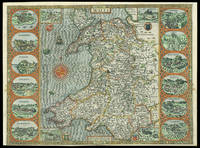
|
|
|
Speed John
Wales : The second part of John Speed's Atlas : "The Theatre of Great Britain"
EP Publishing Ltd 1970. Book. Very Good. hardback. hardback slim folio measuring 16 1/2" x 11" minor foxing to front blanks else a very good tightly bound copy in a part faded pictorial dust wrapper that has a closed tear at head of front flap fold maps 65pp . EP Publishing Ltd Hardcover
書籍販売業者の参照番号
: 235660 ISBN : 0854096140 9780854096145

|
|
|
SPEED John
Wight Island
London: Described by William White Gent Augmented and published by Iohn Speed Citizen of London And are to be solde in Popes head alley against the Exchange by IOhn Sudbury and G. Humbell 1627. 1627. Engraved map with hand colouring. A beautifully coloured map of the Isle of Wight with inset maps of Newport and Southampton. John Speed 1552-1629 was the outstanding cartographer of his age. His ‘Theatre of Great Britain’ was the first atlas of the British Isles: Speed prepared the maps himself about two years before they were published. His maps and books dominated the seventeenth-century English market. The present map is taken from the 1627 English edition published by George Humble. Chubb XXV. Described by William White Gent, Augmented and published by Iohn Speed Citizen of London, And are to be solde in Popes head alle unknown
書籍販売業者の参照番号
: 11781

|
|
|
SPEED John
Worcestershire Described
London: to be solde by Roger Rea the Elder and younger at ye Golden Crosse in Cornhill against the Exchange 1665. 1665. Double-page engraved map fine contemporary outline hand colour upper left and right margins skilfully repaired margins reinforced with japan paper. The map bears the imprint of Roger Rea the Elder and Younger. The Reas had purchased the rights to Speed's work from William Garrett in 1589 who had previously purchased them from the widow of William Humble in the same year. Skelton suggests that the father and son intended a new edition of the atlas for the Restoration of 1660. However the atlas would appear not to have been published until 1665. This is borne out by an advertisement in the Term Catalogue by the subsequent owners of the plates Thomas Bassett and Richard Chiswell in 1675:"Mr John Speed's. Geography of the Kingdoms of England Scotland and Ireland. together with his Prospect. all in one entire Volume hath been for seven Years past out of Print the greatest part of an Impression then newly Printed being destroyed by the late dreadful Fire 1666". This is borne out by the rarity of the Rea edition of the atlas. There is evidence that they planned an edition of 1666 as there are impressions of Sussex Buckingham and Derby with Rea's imprint which bear that date. Rea would later sell the plates to Bassett and Chiswell who would publish a new edition in 1676. to be solde by Roger Rea the Elder and younger at ye Golden Crosse in Cornhill against the Exchange unknown
書籍販売業者の参照番号
: 1773

|
|
|
SPEED John
A Newe Mape of Tartary; 1626 John Speed Map of Tartary
London: George Humble 1626. unbound. Map. Engraving with hand coloring. Image measures 15.25" x 19.75".<br/><br/> This beautiful carte a figures map of Tartary by John Speed presents the many geography speculations found at a time when parts of Asia were largely unexplored by Europeans. Extends from Armenia eastward to include part of North America and includes the Arctic Sea and Nova Zembla.<br><br>Korea is presented as an Island while the Kamchatka Peninsula is entirely absent. The Straits of Anian believed to be associated with the mythical Northwest Passage is identified. The Great Wall of China is depicted in a grand style south of which lies the Kingdom of China. Throughout several kingdoms important cities rivers lakes islands mountains and other topographical features are noted. These includes important cities which were part of the ancient Silk Route.<br><br>The Caspian Sea presented along its East-West Axis according to the practice of the time is identified by various names Sea of Sala otherwise Bachu called by the Russians Chualenske More in old time the Caspian and Hircan Sea. Further north Tazota Island from the Roman geographer Pliny the Elder appears in the Arctic Circle.<br><br>Beijing or Peking appears north of the Great Wall and is identified by the name Cambalu as used my Marco Polo. Interesting notations are also included throughout including one north of the Great Wall reading "In this Country is a hil out of which they dig earth called by Pliny terra Asbestus having fine veines like grasse which being spun and weaved yeeld cloth that wil nut burn in the fire".<br><br>The map is surrounded on the left and right with illustrations of the costumes and people from various parts of the region. Along the top border four views are included detailing the cities Astrakan Samarkand Cambalu and a view of the house of Nova Zembla.<br><br>Engraved by Dirck Grijp. Appears in Speed's important "Prospect of the Most Famous Parts of the World". The map is in good condition with some wear along the original centerfold. Overall foxing and some tape residue long the top margin from framing. Very good impression. English text verso.<br><br>John Speed 1552-1629 is widely considered to be the most famous English cartographer of the 17th century. His atlas "The Theatre of the Empire of Great Britaine" contained the first set of individual county maps of England and Wales as well as significant town plans that are in many cases the first visual records of their subjects. This important map of Asia is a wonderful example of his work.<br/><br/> George Humble unknown books
書籍販売業者の参照番号
: 273459

|
|
|
Speed John
An Atlas of Tudor England and Wales
London: Penguin Books 1953. Forty plates from John Speed's pocket atlas of 1627. Introduced and described by E. G. R. Taylor. 31 1p. plus 40 colored illus. original stiff printed boards King Penguin books 61. Penguin Books unknown books
書籍販売業者の参照番号
: 033292
|
|
|
SPEED John
Anglesey Antiently called Mona
Sudbury & Humble 1610. Map. Engraving with hand coloring. Image measures 15 x 20".<br/><br/> This wonderfully decorated map depicts the island of Anglesey off the northwest coast of Wales. The island is centered on the map and labeled with towns rovers as well pictorial mountains and trees. A strapwork title cartouche features the coat of arms of England flanked by a lion and a unicorn. Below two elegant ships sail the beautifully patterned ocean surrounding an elaborate and colorful compass rose. In the lower left corner of the map showing part of Wales is an ornamental scale topped with strapwork cherubs a peacock and the country's coat of arms. A similar border frames the inset of Beaumaris in the upper right of the map which shows a plan of the port city labeled according to a key including its famous castle. The map appeared in Speed's atlas "The Theatre of the Empire of Great Britaine." It is in good condition with but margins are cropped. Expert repair to right corners. John Speed 1552-1629 is widely considered to be the most famous English cartographer of the 17th century. His atlas "The Theatre of the Empire of Great Britaine" contained the first set of individual county maps of England and Wales as well as significant town plans that are in many cases the first visual records of their subjects. This map of Anglesey is a beautiful example of his work.<br/><br/> Sudbury & Humble unknown books
書籍販売業者の参照番号
: 247261

|
|
|
SPEED John
Asia with the Islands adjoyning described the atire of the people & Towns of importance.; John Speed Map of Asia First British map of Asia ever published
London: George Humble 1627. unbound. Map. Engraving with later hand coloring. Image measures 15.25" x 20".<br/><br/> This fascinating 1627 map of Asia by John Speed is the first British map of Asia. The map presents the entire continent from the Mediterranean east to include Japan and the East Indies. The map presents many speculations and common conventions found at a time when parts of Asia were largely unexplored by Europeans.<br><br>Korea is presented as an elongated peninsula while the Kamchatka Peninsula is entirely absent. The map shows Japan and a fairly detailed depiction of the East Indies. Further west the Caspian Sea is presented along its East-West axis as per the practice at the time. The Great Wall of China is depicted in a grand style. Throughout several kingdoms important cities rivers lakes islands mountains and other topographical features are noted.<br><br>One of the most interesting cartographic feature on this map is the appearance of Lake Ciamay or Lake Chiamay near northeast India. This mythical lake appeared on maps from the 16th to late 18th century and was believed to be the source of the great rivers of Southeast Asia.<br><br>Illustrations of ships and sea monsters are included. The map is surrounded on the left and right with illustrations of the costumes and people from various parts of the continent. Along the top border eight city views are included detailing Candy Goa Damascus Jerusalem Ormus Bantam Aden and Macao.<br><br>Engraved by Abraham Goos 1590 - 1643 a master engraver was the son of Pieter Goos and Margareta van den Keere which were both from map families. Appears in Speed's important "Prospect of the Most Famous Parts of the World". The map is in good condition with some wear and verso repair along the original centerfold. Overall foxing and narrow margins. English text verso.<br><br>John Speed 1552-1629 is widely considered to be the most famous English cartographer of the 17th century. His atlas "The Theatre of the Empire of Great Britaine" contained the first set of individual county maps of England and Wales as well as significant town plans that are in many cases the first visual records of their subjects. This important map of Asia is a wonderful example of his work.<br/><br/> George Humble unknown books
書籍販売業者の参照番号
: 273306

|
|
|
Speed John
John Speed's England. A coloured facsimile of the first edition. Edited by John Arlott. Parts One Three and Four ONLY
London: Phoenix House Limited 1954. First edition. Illustrated. 3 vols. Folio. Three-quarter cloth patterned boards paper labels. Near Fine 3 in slipcases. First edition. Illustrated. 3 vols. Folio. Phoenix House Limited unknown books
書籍販売業者の参照番号
: 223986
|
|
|
SPEED John
Midle-Sex
George Humble. First. unbound. Miniature Map. Engraving. 3 1/4" x 4 1/4"<br/><br/> Rare undated first edition of John Speed's map of Middlesex County from "Theatre" in miniature. Includes lovely rendering of London. John Speed 1552-1629 born in Cheshire and a tailor by profession until he was 50 is widely considered to be the most famous English cartographer of the 17th century. He is noted for placing England in the mainstream of map publishing an industry which was at the time dominated by the Dutch. His atlas "The Theatre of the Empire of Great Britaine" contained the first set of individual county maps of England and Wales as well as significant town plans that are in many cases the first visual records of their subjects.<br/><br/> George Humble unknown books
書籍販売業者の参照番号
: 279246

|
|
|
Speed John
The historie of Great Britaine vnder the conquests of the Romans Saxons Danes and Normans: their originals manners habits warres coines and seales : with the successions liues acts and issues of the English monarchs from Iulius Cæsar vnto the raigne of King Iames of famous memorie. The third edition reuised enlarged and newly corrected with sundry descents of the Saxons kings their marriages and armes.
London: John Dawson for George Humble 1632. Folio pp. 22 1237 i.e. 1281 - page numbers 1043-1086 assigned to recto only 85; includes the preliminary blank leaf; engraved frontispiece portrait of Speed by S. Savery numerous woodcut illustrations and genealogical tables throughout; numerous woodcut initials and ornaments; contemporary full calf perfunctorily rebacked in brown calf maroon morocco label on spine; several clean tears entering text no loss leaf 5a with small piece missing from fore-edge causing minor loss to a few words and numbers light occasional dampstains; a good sound complete copy. A continuation of his Theatre of Great Britaine whose contents are described in this volume as The Chorographicall Part accounting for the first 4 books. This volume The Historicall Part therefore begins with "the fifth booke" but is complete in itself. STC 23049; Graesse V 462-63; Lowndes 2471-72. <br/><br/> John Dawson, for George Humble unknown books
書籍販売業者の参照番号
: 30290

|
|
|
SPEED JOHN
The Theatre of the Empire of Great Britaine: presenting an exact geography of the Kingdomes of England Scotland Ireland and the Iles adioyning. WITH A Prospect of the most famous parts of the World
London: John Sudbury & George Humble; John Dawson for George Humble 1611. 1st Edition. Hardcover. Very Good. THE EARLIEST ATLAS OF THE BRITISH ISLES AD THE EARLIEST WORLD ATLAS BY AN ENGLISHMAN. FIRST EDITION of "The Theatre"; 1611 bound with the second edition 1631 of the "Prospect" "The Theatre of the Empire of Great Britaine. was the earliest English attempt at producing an atlas on a grand scale with the first detailed maps of the provinces of Ireland the first set of county maps consistently attempting to show the boundaries of territorial divisions and the first truly comprehensive set of English town plans-a notable contribution to British topography. Perhaps as many as fifty of the seventy-three towns had not previously been mapped and about fifty-one of the plans were probably Speed's own work. A balance is struck between the modern and historical with information placed on the edges of the maps about antiquarian remains and sites and vignettes of famous battles together with arms of princes and nobles. This additional information is one of the Theatre's most significant contributions" Dictionary of National Biography. The "Theatre" is complete with engraved architectural title engraved Royal Achievements by Jodocus Hondius dated 1611 letterpress list of kingdoms and woodcut royal arms three letterpress section titles with woodcut borders three woodcut royal arms 67 double-page engraved maps most by Jodocus Hondius woodcut head- and tail-pieces and initials mounted on guards throughout. The "Prospect" was intended as a supplement to the "Theatre" and includes 22 maps of different parts of the world including the famous world map presumably by Abraham Goos and the map of America both showing California as an island. With engraved portrait frontispiece bound before "Theatre". NOTE: The "Prospect" is lacking "Invasions" but with 'Canaan' bound in its place and lacking the final text leaf on 'Civill Warres'. Also with portrait trimmed to platemark and laid down. Provenance: J.B. Speed Art Museum Louisville Kentucky bookplate. London: John Sudbury & George Humble; John Dawson for George Humble 1611; 1631. Folio 414x287mm 19th-century full calf with elaborately gilt-decorated spine. Joints repaired small chip to label. Some offsetting including on the world map some marginal repaired closed tears some maps closely cropped. Most maps including the world map with good strong impressions. John Sudbury & George Humble; John Dawson for George Humble hardcover books
書籍販売業者の参照番号
: 956

|
|
|
Speed John 1552 1629
A Prospect of the Most Famous Parts of the World with England Wales Scotland and Ireland Described and Abridged with ye Historical Relation of Things Werthy Memory from a Far Larger Volume.
London: George Humble 1646 and 1627. Hardcover. Very good. Two works in one volume. Oblong octavo measuring 6 1/4 x 3 7/8 inches 16 x 9.75 cm.Rebound in full brown pebbled morocco with new tan endpapers. With custom made drop back folding clamshell slipcase in complementary tan cloth with leather spine labes stamped in gilt. First part with engraved title plus 19 engraved maps as called for. Second part with engraved title bound in upside down and remargined; Sixty - four maps called for in the index. Lacks map of England Scotland and Ireland1 and final map entitled MIDIA 64. Yorkshire map is missing section folded in from fore edge. 81 maps of 83 called for PLUS two engraved title pages. Some interior stains and foxing but still quite acceptable. A series of images is available on request. <br/><br/> George Humble hardcover books
書籍販売業者の参照番号
: 9025633
|
|
|
SPEED John c. 1552 1629
A Map of Virginia and Maryland
London: Thomas Basset & Richard Chiswell 1676. Copper-engraved map. Image area: 15 1/4 x 20 inches. Very good. Matted. The first state of Speed's early map of Virginia.<br/> <br/>As noted by Burden this was the first map to incorporate information from Augustine Hermann's Virginia and Maryland As it is Planted and Inhabited this present Year 1670 a landmark map of the region. While the general outlines of the map are taken from John Smith's map of 1612 much of the toponomy derives from Hermann as well as the representation of Delaware Bay which did not appear on Smith's map and a more accurate depiction of the northeastern shore of Chesapeake Bay. With very interesting text on the verso condensed from John Ogilby's America published in 1671.<br/> <br/>£Burden 456. Thomas Basset & Richard Chiswell unknown books
書籍販売業者の参照番号
: 34894

|
|
|
SPEED John c. 1552 1629
Denbighshire
London: Henry Overton Bassett & Chiswell 1713. Copper-engraved map with full modern colour very large marings in very good condition except for a stain at the bottom edge well away from the image. A highly decorative map of Denbighshire by one of the greatest English cartographers<br/> <br/>Denbighshire in Wales clearly a mountainous region was surveyed by Christopher Saxton which was Speed's source for this map. William Smith Pursuivant at the College of Arms was the apparent source for the coats of arms: one of which is that of Robert Dudley Earl of Leicester Queen Elizabeth's favorite. In the town plan of Denbigh in the upper right corner is a circular inset displaying what appears to be a castle. It is actually an unfinished and indeed never finished church that Leicester had tried to have built in Denbigh. Apparently his unpopularity was part of the reason the church was never completed. The map is decorated with a sea monster a classical god on horseback and a ship. Henry Overton's edition of this map includes the few roads that snaked their way through the county.<br/> <br/>cf. Hawkyard and Nicolson The Counties of Britain A Tudor Atlas by John Speed p. 73-76; Skelton The County Atlases of the British Isles 1579-1850 Map Collector's Circle part 1 #7 Speed and part 4 #92 & 121. Henry Overton, Bassett & Chiswell unknown books
書籍販売業者の参照番号
: 12789

|
|
|
SPEED John c. 1552 1629
The Historie of Great Britaine under the Conquests of the Romans Saxons Danes and Normans Their Originals Manners Habits Warres Coins and Seales; with the Successions Lives acts & Issues of the English Monarchs from IULIUS CAESAR to our most gracious Soueraigne King IAMES
London: Printed by John Beale for George Humble 1623. Second edition. Hardcover. Very Good. Folio 340 x 220mm. xx 1258pp. 74 numerous error in paging and register. Signatures: par.6 1st leaf blank A8; B-2H6; I4; 2K-4S6; 4T4; 4V-4Y6; 4Z8 4Z8 sic 4Z4; 5A-5T6; 5V1 of 4. Printers device of Humble on title head- and tail- pieces and initials throughout. Many in text engravings including 8 full page genealogies and numerous woodcuts throughout of coins and seals. Text in double column. Period full English calf rebacked and restored at corners in modern leather and stamped in gilt Historie of Great Britain Speed; lacking frontis. title somewhat browned and remargined text block lightly browned around edges lacking final 3 leaves of Table otherwise good. Sold as is. Large white on black bookplate of Dr. Otto Orren Fisher of Detroit Michigan to front pastedown. <br/><br/>Second Edition of Speeds Historie of Great Britain. Second Edition revised and enlarged and reissued in 1625 and again in 1627; Speeds Historie of Great Britain was originally published in 1612 with The Theatre of the Empire of Great Britaine as a companion volume though continuously paginated The Historie being the second work and the contents listing refers to the first four books which were part of the Theatre although this work books 5 - 10 is complete in itself. His account of the reign of Henry VIII p. 998 is followed by an appendix described in the running head as A Catalogue of the Religious Houses Colledges and Hospitals sometimes in England and Wales. These sections hold a wealth of information on early successors and founders of English Institutions. It was likely Speed an apt historian himself borrowed many of his materials from William Camden and was supplied by many Sir Robert Cotton Sir Henry Spelman and other antiquaries with whom he was acquainted. Although he probably had access to historical sources that are now lost to us he certainly used the work of Saxton and Norden his work as a historian is considered mediocre and secondary in importance to his map-making and the town plans he drew. Despite its many defects the Historie was very frequently cited by later writers. An important rich historical and artifactual book on Early English history. STC 2nd ed. 23046.3 Printed by John Beale for George Humble hardcover books
書籍販売業者の参照番号
: LD8073
|
|
|
Speed John.
The historie of Great Britaine under the conquests of the Romans Saxons Danes and Normans. Their originals manners habits warres coines and seales: with the successions lives acts and issues of the English monarchs from Iulius Caesar unto the raigne of King Iames of famous memorie.
London: Pr. by John Dawson and Thomas Cotes for George Humble 1632. Folio 33.5 cm 13.25". 10 ff. 1042 pp.; 10431086 ff. 10871237 85 index pp. lacking frontis.; illus. <br><br>Third edition of this archetypal early English history a variant of the 1631 edition. Printed with all the archaic and "curious" spellings one could hope for in such a work e.g. "Britaine" and "ye" on the title-page each page bears both roman and italic types; the text contains a number of intricate initials headpieces and tailpieces and is adorned with detailed woodcuts of kings their coats of arms and the seals and coinage of their reigns. The illustrations are as notable as the typography for quaint charm.<br>Â Â Â Â Speed 15521629 a cartographer and historian published the Historie as a continuation of his Theatre of Great Britaine both works being listed in the table of contents of this work which explains the volume's peculiar pagination and arrangement.<br>Â Â Â Â => An epitome of the "antiquarian" both in form and content this is a marvelous compendium of royal history and lore. <br>Â Â Â Â <br>Â Â Â Â ESTC S997; STC rev. ed. 23049; Graesse 46263; Lowndes 247172. Period-style calf framed panelled stamped in gilt; spine gilt extra with gilt-stamped leather title and author labels; Starr Bookworks. Light to moderate waterstaining with traces of now-arrested mildew in the form of intermittent and usually faint pink staining/spotting. Frontispiece lacking; title-page partially mounted; dedication and first few leaves of contents with inner margins reinforced. Pp. 41/42 with tear from lower margin into text lower edge of tear repaired; pp. 125/26 with lower outer corner torn away and replaced without loss of text; pp. 271/72 with lower portion replaced with loss of several paragraphs and the lower half of one image; pp. 449/50 with lower outer corner replaced with loss of lower portion of one decorated capital about three lines of text and small portion of tailpiece; pp. 597/98 with small portion of outer margin repaired with loss of one shouldernote; pp. 981/82 with an arc of the coin on the latter excised; pp. 1005/06 with portion of outer margin torn away with partial loss of one shouldernote; pp. 1041/42 with lower and outer margins partially cut away along frame of text block without loss. Pp. 1087/88 with lower portion excised text replaced in an early inked hand; pp. 1237/38 mounted with loss of an image and two paragraphs of text. One index leaf with lower outer portion excised with loss of about 15 lines of text; final index leaf with lower outer corner torn away and repaired text partially reconstructed in an early inked hand. One coat of arms drawn in by hand where the shield had been left blank. Definitely an imperfect copy; yet in fact definitely not a devastated one. Pr. by John Dawson [and Thomas Cotes] for George Humble hardcover books
書籍販売業者の参照番号
: 24405

|
|
|
Speed Jon.
Mauser Archive
Collector Grade 20087. 2007. 546p. Photos. Line drawings. Oversize. As New/As New copy. Hardcover. As New/As New. Book. Collector Grade, 20087. Hardcover
書籍販売業者の参照番号
: 64-1048 ISBN : 0889354375 9780889354371
|
|
|
Speed Jon;Stevens R. Blake;Schmid Walter;Herrmann Reiner
Mauser Original Oberndorf Sporting Rifles
Canada: Collector Grade Publications. Fine/Near Fine D. J. 1997. First Edition. Hard Cover. 0889352305 Fine clean hard cover first edition with near fine dust jacket. Size: 8vo - over 7�" - 9�" Tall; Oblong . Collector Grade Publications hardcover
書籍販売業者の参照番号
: 032510 ISBN : 0889352305 9780889352308
|
|
|
Speed Jon
Mauser Small Bores : Sporting Target and Training Rifles
Cobourg ON Canada: Collector Grade Publications. Fine/Fine D. J. 1998. First Edition. Hard Cover. 0889352445 Fine clean hard cover first edition with fine dust jacket. Size: 8vo - over 7�" - 9�" Tall; Oblong . Collector Grade Publications hardcover
書籍販売業者の参照番号
: 032509 ISBN : 0889352445 9780889352445
|
|
 検索結果のメールを受信する
 PDFファイルの検索結果をダウンロード
 RSSフィード


