|
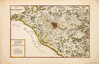
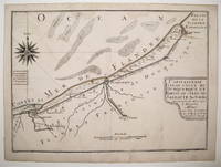
FER Nicolas de.
Les Environs de Rome.
Paris c1700-05. Size: 290 x 440 mm. Copperplate engraving with later hand colour. Good condition some slight toning and creasing. Nicolas de Fer was the son of Antoine de Fer a Parisian map and print seller. This map from the Atlas Curieux shows the environs of Rome. At the time of publication de Fer was the official cartographer to the French Dauphin but he later became cartographer to both the French and Spanish kings. Paris unknown
Bookseller reference : 70256
|
|
|
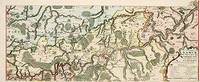
FER Nicolas de.
Les Environs de Dinant de Philippeville et de Charlemont ou se Trouve encore Le Condros
Paris. 1705. Copper engraving. Later colouring. Fine condition Size: 59 x 22 cm. An attractive map of part of Belgium showing forests and river valleys. 'de Fer's maps are popular despite or maybe because of their rather flamboyant decoration' Moreland & Bannister p130. Title at lower right. Atlas Curieux ou Le Monde. Moreland and Bannister Paris. unknown
Bookseller reference : 52950
|
|
|
FER Nicolas de.
Les Environs de NAMUR de Huy et de Charle-Roy
Paris. 1717. Copper engraving. Original colour. Fine condition Size: 59 x 23 cm. An attractive map of part of Belgium showing forests and river valleys. 'de Fer's maps are popular despite or maybe because of their rather flamboyant decoration' Moreland & Bannister p130. Title at lower right. Atlas Curieux ou Le Monde. Paris. unknown
Bookseller reference : 52951
|
|
|
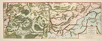
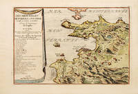
FER Nicolas de
Les Eveschés de Trente et de Brixen. Le Comté de Tirol et les Etats de la Republique de Venise dans le Fond du Golfe.
Paris c1705. Size: 275 x 400 mm. Coloured copperplate engraving. Very good condition. Nicolas de Fer inherited a respectable cartographic business in Paris from his parents and turned it into a flourishing enterprise by the end of the seventeenth century. De Fer became "Geographer of his Catholic Majesty and his Highness the Dauphine". This wonderful map of northern Italy and of the Tirol is from his "Atlas Curieux ou Le Monde.". The region covered is highly mountainous and well forested. The map features Lake Garda in the south to Kufstein and Innsbrück in the north The Gulf of Venice and Friuli. Paris unknown
Bookseller reference : 76910

|
|
|
FER Nicolas de.
Les forces de l' Europe ou description des principales villes; avec leurs fortifications. . . . Paris "chez l'auteur" =Nicolas de Fer a false imprint 1695-1696 printed in Amsterdam for Pieter Mortier 1695-ca. 1702. 10 parts in 1 volume. With 234 beautifully engraved plates a few folding with 366 maps and views of fortified cities. With: 2 FER Nicolas de. Costes de France sur l' ocean & sur la Mer Mediterranée &c. avec leurs fortifications. . . . Paris "Nicolas de Fer" a false imprint 1695. printed in Amsterdam for Pieter Mortier. With engraved title-page and 40 engraved plates including 2 folding. 2 works in 12 parts or volumes bound as 1 volume. Oblong 1mo 30×37 cm. Contemporary tanned sheepskin gold-tooled spine.
Splendid atlas of fortifications of the cities of Europe plus Malta and some other Mediterranean sites combined with a maritime atlas of the French coasts published by Pieter Mortier 1661-1711. Both are based on the similar publications of Nicolas de Fer 1646-1720 and falsely indicate that they were published by him.Ad 1: The atlas of fortified cities of Europe. Many of the plans show the work of the greatest 17th-century masters of the art and science of fortification including Samuel Marolois Simon Stevin and Sébastien Le Prestre de Vauban. The last two parts contain primarily smaller maps printed 4 to the page. Ad 2: The maritime atlas of the coasts of France. It also shows the fortifications along the coasts so it complements the fortifications atlas and was clearly designed to match it in format and style. With the caption of one plate cut off and 2 plates and 1 letterpress title-page somewhat browned. Further in good condition. A couple plates are bound in the wrong volume. A splendid fortifications atlas.l Ad 1: Muller Historieplaten 3034a; cf. Pastoureau Atlas français IX A & H pp. 203-209 213; ad 2: Muller Historieplaten 3034a; Pastoureau Les atlas français XVIe-XVIIe siècles Fer VIII B p. 203 cf. pp. 201-203. unknown
Bookseller reference : 23526
|
|
|
Fer Nicolas de Vauban Sebastien le Prestre marquis de Loon H. van Loisel L. ? ? Coquart Antoine Gournay Claude ..
Les forces de l'Europe ou Description des principales villes avec leurs fortifications Material cartográfico : Dessinées par les meilleurs ingenieurs; particulierement celles qui sont sous la domination de la France dont les plans ont estée levez par Monsieur de Vauban . & aussi la description de tous les instrumens servans áa la fortification áa l'attaque & deffense des places ensemble ceux qui servent pour l'artillerie la maniere de dresser un camp devant une ville assiegée 1695 Leather Bound
2020. Leather Bound. New. Leather Binding on Spine and Corners with Golden Leaf Printing on round Spine extra customization on request like complete leather Golden Screen printing in Front Color Leather Colored book etc. Reprinted in 2020 with the help of original edition published long back 1695. This book is printed in black & white sewing binding for longer life Printed on high quality Paper re-sized as per Current standards professionally processed without changing its contents. As these are old books we processed each page manually and make them readable but in some cases some pages which are blur or missing or black spots. If it is multi volume set then it is only single volume if you wish to order a specific or all the volumes you may contact us. We expect that you will understand our compulsion in these books. We found this book important for the readers who want to know more about our old treasure so we brought it back to the shelves. Hope you will like it and give your comments and suggestions. Lang: - fre Pages 376. EXTRA 10 DAYS APART FROM THE NORMAL SHIPPING PERIOD WILL BE REQUIRED FOR LEATHER BOUND BOOKS. COMPLETE LEATHER WILL COST YOU EXTRA US$ 25 APART FROM THE LEATHER BOUND BOOKS. FOLIO EDITION IS ALSO AVAILABLE. hardcover
Bookseller reference : LB1111017143740
|
|
|
Fer Nicolas de Vauban Sebastien le Prestre marquis de Loon H. van Loisel L. ? ? Coquart Antoine Gournay Claude ..
Les forces de l'Europe ou Description des principales villes avec leurs fortifications Material cartográfico : Dessinées par les meilleurs ingenieurs; particulierement celles qui sont sous la domination de la France dont les plans ont estée levez par Monsieur de Vauban . & aussi la description de tous les instrumens servans áa la fortification áa l'attaque & deffense des places ensemble ceux qui servent pour l'artillerie la maniere de dresser un camp devant une ville assiegée 1695
2020. Softcover. New. Lang: - fre Pages 376. Reprinted in 2020 with the help of original edition published long back 1695. This book is Printed in black & white sewing binding for longer life with Matt laminated multi-Colour Soft Cover HARDCOVER EDITION IS ALSO AVAILABLE Printed on high quality Paper re-sized as per Current standards professionally processed without changing its contents. As these are old books we processed each page manually and make them readable but in some cases some pages which are blur or missing or black spots. If it is multi volume set then it is only single volume if you wish to order a specific or all the volumes you may contact us. We expect that you will understand our compulsion in these books. We found this book important for the readers who want to know more about our old treasure so we brought it back to the shelves. Any type of Customisation is possible. Hope you will like it and give your comments and suggestions. paperback
Bookseller reference : PB1111017143740
|
|
|
Fer Nicolas de Vauban Sebastien le Prestre marquis de Loon H. van Loisel L. ? ? Coquart Antoine Gournay Claude ..
Les forces de l'Europe ou Description des principales villes avec leurs fortifications Material cartográfico : Dessinées par les meilleurs ingenieurs; particulierement celles qui sont sous la domination de la France dont les plans ont estée levez par Monsieur de Vauban . & aussi la description de tous les instrumens servans áa la fortification áa l'attaque & deffense des places ensemble ceux qui servent pour l'artillerie la maniere de dresser un camp devant une ville assiegée 1695 Full Leather Bound
2020. SUPER DELUXE EDITION. New. Antique look with Golden Leaf Printing and embossing with round Spine completely handmade bindingextra customization on request like Color Leather Colored book special gold leaf printing etc. Reprinted in 2020 with the help of original edition published long back 1695. This book is printed in black & white sewing binding for longer life Printed on high quality Paper re-sized as per Current standards professionally processed without changing its contents. As these are old books we processed each page manually and make them readable but in some cases some pages which are blur or missing or black spots. If it is multi volume set then it is only single volume if you wish to order a specific or all the volumes you may contact us. We expect that you will understand our compulsion in these books. We found this book important for the readers who want to know more about our old treasure in old look so we brought it back to the shelves. Hope you will like it and give your comments and suggestions. Lang: - fre Pages 376. EXTRA 10 DAYS APART FROM THE NORMAL SHIPPING PERIOD WILL BE REQUIRED. Normal Hardbound Edition is also available on request. unknown
Bookseller reference : SD1111017143740
|
|
|
Fer Nicolas de Vauban Sebastien le Prestre marquis de Loon H. van Loisel L. Coquart Antoine Gournay Claude .. I
Les forces de l'Europe ou Description des principales villes avec leurs fortifications Material cartográfico : Dessinées par les meilleurs ingenieurs; particulierement celles qui sont sous la domination de la France dont les plans ont estée levez pa 1695 Leather Bound
2019. Leather Bound. New. Leather Binding on Spine and Corners with Golden Leaf Printing on round Spine. Reprinted in 2019 with the help of original edition published long back 1695. This book is printed in black & white sewing binding for longer life Printed on high quality Paper re-sized as per Current standards professionally processed without changing its contents. As these are old books we processed each page manually and make them readable but in some cases some pages which are blur or missing or black spots. If it is multi volume set then it is only single volume if you wish to order a specific or all the volumes you may contact us. We expect that you will understand our compulsion in these books. We found this book important for the readers who want to know more about our old treasure so we brought it back to the shelves. Hope you will like it and give your comments and suggestions. Lang: - fre Pages 192. EXTRA 10 DAYS APART FROM THE NORMAL SHIPPING PERIOD WILL BE REQUIRED FOR LEATHER BOUND BOOKS. FOLIO EDITION IS ALSO AVAILABLE. hardcover
Bookseller reference : LB1111008653703
|
|
|
Fer Nicolas de Vauban Sebastien le Prestre marquis de Loon H. van Loisel L. Coquart Antoine Gournay Claude .. I
Les forces de l'Europe ou Description des principales villes avec leurs fortifications Material cartogr�fico : Dessin�es par les meilleurs ingenieurs; particulierement celles qui sont sous la domination de la France dont les plans ont est�e levez pa 1695 Hardcover
2020. Hardcover. New. Lang: - fre Pages 192. Reprinted in 2020 with the help of original edition published long back 1695. This book is Printed in black & white Hardcover sewing binding for longer life with Matt laminated multi-Colour Dust Cover Printed on high quality Paper re-sized as per Current standards professionally processed without changing its contents. As these are old books we processed each page manually and make them readable but in some cases some pages which are blur or missing or black spots. If it is multi volume set then it is only single volume if you wish to order a specific or all the volumes you may contact us. We expect that you will understand our compulsion in these books. We found this book important for the readers who want to know more about our old treasure so we brought it back to the shelves. Any type of Customisation is possible with extra charges. Hope you will like it and give your comments and suggestions. hardcover
Bookseller reference : 1111008653703
|
|
|
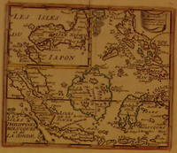
FER Nicolas de
Les Isles Philippines Molucqes et de la Sonde
Paris: de Fer Nicolas. unbound. very good. Map. Engraving with modern hand coloring. Image measures 5.5" x 6.5". Rare and unusual map of the Phillipines with an inset of Japan circa 1720. Names Sincapura and Balli. With centerfold. Nicolas de Fer 1646-1720 was a French cartographer engraver and publisher. He became official geographer to the French Dauphin 1691 and to the Spanish King 1702. de Fer, Nicolas unknown
Bookseller reference : 202640
|
|
|
FER Nicolas de.
Les Merveilles de Pozzoli ou Pouzzol Cume et Baia ou Bayes.
Paris 1700-05. Size: 270 x 405 mm. Copperplate engraving with later hand colour. Good condition. Slightly toned. Pozzoli is a province of Naples and the main city of the Phlegrean Peninsula. It lies some two miles from the once fashionable resort of Baia. The map is well executed and detailed. Nicolas de Fer was the son of Antoine de Fer a Parisian map and print seller. This map from the Atlas Curieux. At the time of publication de Fer was the official cartographer to the French Dauphin but he later became cartographer to both the French and Spanish kings. Paris unknown
Bookseller reference : 70272
|
|
|
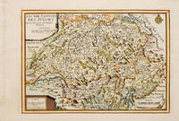
FER Nicolas de.
LES XIII CANTONS DES SUISSES.
Atlas Curieux ou le Monde. Paris 1717. Copper engraving. Later colour. Fine condition Size: 348 x 240 mm. 13½ x 9½ iinches Map of Switzerland with title at top left dedication and scales in lower corners Atlas Curieux ou le Monde. unknown
Bookseller reference : 53085
|
|
|
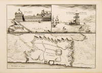
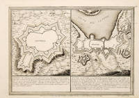
FER Nicolas de. Engraved by Coquart A.
Lisbonne.
Atlas Curieux ou le Monde. c.1710. Copper engraving. Uncoloured. Fine condition. Size: 330 x 240 mm. 13 x 9½ inches. The lower half of this attractive engraving shows a map of the fortifications of Lisbon. The upper half has two views- To the left the 'Palais Royal de Lisbonne' and to the right 'Le Chateau de Belem'. Atlas Curieux ou le Monde. unknown
Bookseller reference : 53827
|
|
|
FER Nicolas de.
Mantoue
1705. Copper engraving. Later colouring. Fine condition Size: 34 x 23 cm. 13½ x 9 inches A plan of the town fortifications and surrounding area unknown
Bookseller reference : 52739
|
|
|
Fer Nicolas de
Map Le Vieux Mexique ou Nouvelle Espagne avec les costes de la Floride
Paris: Chez l'Auteur 1702. First printing. Map folio sheet 12.75"x9" 23x33cm. Copperplate engraving. Significant early map of this area locating the mouth of the Mississippi correctly as taken from the information reported by M. La Salle. The right edge includes all of Florida and most of Cuba; the left cuts off most of Baja California. Santa Fe New Mexico is shown at the top the bottom cuts off at the Isthmus of Panama. Attractive cartouche showing two Indians in full regalia. Hand-colored probably contemporaneously. Fine copy. <br/><br/> Chez l'Auteur unknown
Bookseller reference : 6200
|
|
|
FER Nicolas de.
Olivenca & Setuval.
Paris. 1705. Size: 275 x 395 mm. Copperplate engraving. Fine condition. An interesting and unusual map depicting the basic fortifications of two Portuguese towns. Published in the 'Atlas Curieux ou Le Monde'. Paris. unknown
Bookseller reference : 65686
|
|
|
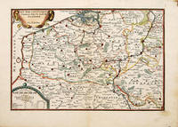
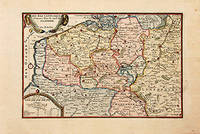
FER Nicolas de.
Pais Bas Catoliques Connues Sous le nom de Flandre
1702. Copper engraving. Later colouring. Size: 33 x 22 cm. 13 x 8½ inches unknown
Bookseller reference : 52396
|
|
|
FER Nicolas de.
Païs Bas Catoliques connues sous le nom de Flandre.
Paris: 1717. Sheet size: 274 x 405 mm Plate size: 216 x 326 mm Copper engraving. Hand coloured. Very good condition. Map of the Catholic Low Countries or current day Belgium. Published in "Atlas Curieux ou le Monde". Paris: unknown
Bookseller reference : 78864
|
|
|
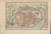
Fer Nicolas de
Plan de la Fameuse et Nouvelle Ville de Mexique
Paris. Very Good. 1715. Map. Lovely engraved map depicting Mexico City in the early 18th century. Map is on a 10 �" x 15 �" sheet that was taken from Nicolas de Fer's "L'Atlas Curieux" of 1715; no content on verso. Date of map was printed in upper margin along with the sheet number "125" and title; content in French. Hand-coloring is still bright. Map has very light toning to edges but is otherwise clean. This detailed map depicts Mexico City when it was surrounded by water and was linked to the mainland by the famous causeways originally designed by the Aztecs. Also pictured are aqueducts and farms and about 50 locations have been numbered on the map but the key is not present likely printed on another page in the Atlas. A beautiful map. . unknown
Bookseller reference : 019811
|
|
|
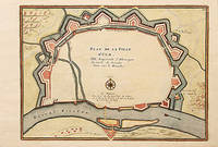
FER Nicolas de.
Plan de la Ville d'Ulm.
Paris: 1705. Size: 277 x 403 mm Copper engraving. Hand coloured. Good condition. A beautiful city plan of Ulm in the federal German state of Baden-Württemberg. Paris: unknown
Bookseller reference : 78550
|
|
|
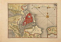
FER Nicolas de.
Plan de Straalsund.
Paris: 1716. Sheet size: 275 x 404 mm Plate size: 230 x 332 mm Copper engraving. Hand coloured. Good condition. A beautiful city plan of Stralsund in Germany just off the island of Rugen in the Baltic Sea. Paris: unknown
Bookseller reference : 78549
|
|
|
FER Nicolas de.
Plan des environs de Dunkerque et Mardick avec le Nouveau Canal.
Paris: c.1717. Size: 275 x 398 mm Copper engraving. Hand coloured. Very good condition. Map of the towns of Dunkirk and Mardick showing the new canal. Published in "Atlas Curieux ou le Monde". Paris: unknown
Bookseller reference : 78680
|
|
|
FER Nicolas de.
PLANO CON LAS FORTIFICACIONES DE PUIGCERD� CATALU�A - PUICERDA ville forte de Catalogne du Comt� de Sardagne au Roy d'Espagne Situ�e sur la riviere du Segre a 42 degr�es 4 minutes de latitude et a 22 degr�es 25 minutes de longitude.
Plano grabado al cobre de 22 x 29 cm. Amplios m�rgenes. Bien conservado. Escala en toesas. Publicado en "Les Forces de l'Europe" publicado en Par�s en 1695. unknown
Bookseller reference : 12920869
|
|
|
FER Nicolas de.
PLANO CON LAS FORTIFICACIONES DE CAMPROD�N CATALU�A - CAMPREDON ville forte de Catalogne situ�e sur la Riviere du Ter a 41 degrees 50 mnutes de Latitude et a 22 degrees 18 minutes de Longitude. Cette Place fut assieg�e et prise par les Fran�ois sur les Espagnols en 1689 apres 5 jours de Tranch�e ouverte.
Plano grabado al cobre de 22 x 29 cm. Amplios m�rgenes. Bien conservado. Publicado en "Les Forces de l'Europe" publicado en Par�s en 1695. La villa de Camprod�n fue tomada por los franceses el duque de Noailles en 1689 en las guerras de Carlos II contra Luis XIV. Al ser reconquistada por el duque de Villahermosa del R�o este hizo volar el castillo que hab�an malogrado los franceses.Este es el plano con las fortificaciones existentes en la �poca del asedio. unknown
Bookseller reference : 12920868
|
|
|
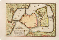
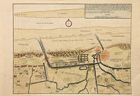
FER Nicolas de.
Veue generale de la Maison et des Jardins de Nieuburg pres du village de Riswick
Paris: 1705. Size: 275 x 400 mm Copper engraving. Hand colouring. Good condition. Nicolas de Fer's excellent plan of the Nieuburg House where the treaty of Ryswick in the Netherlands was signed in 1697 and not 1705 as stated in the print. From the "Atlas Curieux ou Le Monde". Paris: unknown
Bookseller reference : 78538
|
|
|
FER Nicolas de
Capitainerie garde-coste de Dunquerque et partie de celle de Sangatte
Map. Engraving with original hand coloring. Image measures 8.75" x 12".<br/><br/> This charming map of Dunkirk shows the city as it sits on the coast of the southernmost part of the North Sea here labeled as the Sea of Flanders. Working circa 1705 De Fer has represented the city with a schematized drawing of its exterior walls. Canals connecting the city to nearby towns and churches are also depicted and labeled. Sand bars are drawn and mountains are represented pictorically and a decorative compass rose at the upper left points due north. The map is in very good condition with no chips or tears and minor staining. Nicolas de Fer 1646-1720 was a French cartographer engraver and publisher. He became official geographer to the French Dauphin 1691 and to the Spanish King 1702 and was renowned particularly for his maps of the French coast of which this is a fine example.<br/><br/> unknown books
Bookseller reference : 239457
|
|
|
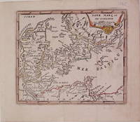
FER Nicolas de
Dane Marq et Sud-Gothlande
Paris: de Fer Nicolas 1725. unbound. very good. Map. Engraving with modern hand coloring. Image measures 5.25" x 6.25".<br/><br/> Charming miniature map of Denmark with the Coat of Arms incorporated in the cartouche. Map includes both Schleswig and Holstein while today part of the former and all of the latter are northern Germany. Nicolas de Fer 1646-1720 was a French cartographer engraver and publisher. He became official geographer to the French Dauphin 1691 and to the Spanish King 1702.<br/><br/> de Fer, Nicolas unknown books
Bookseller reference : 204942
|
|
|
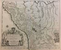
FER Nicolas de
Le Perou Dans L'Amerique Meridionale
Paris 1719. Map. Engraving with original hand outline color. Image measures 19 x 23". Sheet measures 20 x 28".<br/><br/> Unusual map of Peru from the early 18th century. Includes part of Ecuador Bolivia and Brazil based on Jesuit activity in the area. Amazon rain forest is visualized with a dynamic design. Cartouche describes the mining industry. Nicolas de Fer 1646-1720 was a prolific cartographer engraver and publisher who took over the family map business from his mother when she retired in 1687. The business flourished and he gained a great reputation in his lifetime and was appointed 'Geographer to the King' in 1690. This map demonstrates his skill and provides a curious yet alluring mixture of history and geography.<br/><br/> unknown books
Bookseller reference : 291534
|
|
|
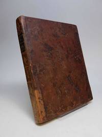
FER Nicolas de
Les Costes de France sur l'Ocean et sur la Mer Mediterranee Corigees Augmentees et Divisees en Capitaineries Garde-Costes
hardcover. Dediees a Monseigneur le Dauphin par Sontres Humble et tres Obeissant Serviteur et Geographe De Fer. Beautiful double-page engraved title page 4 38 2 60 28pp. This splendid atlas is illustrated with 32 engraved coastal charts including a folding wind chart and a general index chart of France. The double page maps have delicate outline hand coloring. An engraved divisional title page number 26 entitled "Les Costes de la Mer Mediterranee" is the 33rd plate. Short 4to 9.5 x 7.75 inches 17th Century calf well-worn; neatly rebacked; marbled endpapers red edges. Paris: Chez le Sr. de Fer dans l'Isle du Palais sur Quay de l'Orloge a la Sphere Royale. Avec Pri. du Roy 1690.<br/><br/> Nicolas de Fer 1646-1720 was a prolific cartographer engraver and publisher who took over the family map business from his mother when she retired in 1687. The business flourished and he gained a great reputation in his lifetime and was appointed 'Geographer to the King' in 1690. This original edition the first atlas to bear his name was published in 1690 on the basis of an atlas published in 1634 by order of Cardinal Richelieu by the publisher Tassin who sold his plates in 1644 to Antoine de Fer Nicolas's father. Scarce.<br/><br/> unknown books
Bookseller reference : 156417
|
|
|
FER Nicolas de
Les Isles Philippines Molucqes et de la Sonde
Paris: de Fer Nicolas. unbound. very good. Map. Engraving with modern hand coloring. Image measures 5.5" x 6.5".<br/><br/> Rare and unusual map of the Phillipines with an inset of Japan circa 1720. Names Sincapura and Balli. With centerfold. Nicolas de Fer 1646-1720 was a French cartographer engraver and publisher. He became official geographer to the French Dauphin 1691 and to the Spanish King 1702.<br/><br/> de Fer, Nicolas unknown books
Bookseller reference : 202640
|
|
|
Fer Nicolas de
Map Le Vieux Mexique ou Nouvelle Espagne avec les costes de la Floride
Paris: Chez l'Auteur 1702. First printing. Map folio sheet 12.75"x9" 23x33cm. Copperplate engraving. Significant early map of this area locating the mouth of the Mississippi correctly as taken from the information reported by M. La Salle. The right edge includes all of Florida and most of Cuba; the left cuts off most of Baja California. Santa Fe New Mexico is shown at the top the bottom cuts off at the Isthmus of Panama. Attractive cartouche showing two Indians in full regalia. Hand-colored probably contemporaneously. Fine copy. <br/><br/> Chez l'Auteur unknown books
Bookseller reference : 6200
|
|
|
Fer Nicolas de
Plan de la Fameuse et Nouvelle Ville de Mexique
Paris. Very Good. 1715. Map. Lovely engraved map depicting Mexico City in the early 18th century. Map is on a 10 ¾" x 15 ¾" sheet that was taken from Nicolas de Fer's "L'Atlas Curieux" of 1715; no content on verso. Date of map was printed in upper margin along with the sheet number "125" and title; content in French. Hand-coloring is still bright. Map has very light toning to edges but is otherwise clean. This detailed map depicts Mexico City when it was surrounded by water and was linked to the mainland by the famous causeways originally designed by the Aztecs. Also pictured are aqueducts and farms and about 50 locations have been numbered on the map but the key is not present likely printed on another page in the Atlas. A beautiful map. . unknown books
Bookseller reference : 019811
|
|
|
Fer Yannick
Diasporas asiatiques dans le Pacifique : Histoire des repr�sentations et enjeux contemporains
Les Indes savantes 2014. Paperback. New. French language. 9.29x6.22x0.55 inches. Les Indes savantes paperback
Bookseller reference : 2-2846543739 ISBN : 2846543739 9782846543736
|
|
|
FER (Nicolas de)
[Carte géographique]. Le Cercle de Souabe et partie de Celuy de Franconie.
Paris, Chez l'auteur, fin XVII°s. 60,7 x 47,3 cm à la cuvette + marges.
Bookseller reference : 14261
|
|
|
Fer (Nicolas de)
Histoire des Rois de France depuis Pharamond jusqu'à notre auguste Monarque Louis Quinze, Enrichie de leurs portraits et faits les plus mémorables, composées de soixante et cinq planches en taille douce. uvre posthume par N. de Fer. Dédiée au Roy.
1722 1722 J.F. Bernard, Paris, 1722.1 volume in-4 plein veau d'époque, dos à nerfs orné de fleurons en encadrement de filets, pièce de titre, [2ff.] blancs, [141ff.] non chiffrés et [1f.] blanc. Bien complet des 65 gravures en taille-douce (chiffrées de 4 à 69, la page de titre, l'épître et la table comptant pour les gravures 1 à 3). Chaque notice royale et accompagnée d'une gravure présentant un portrait et une figure allégorique. Ex-libris. Bel exemplaire malgré quelques épidermures.
Bookseller reference : 2659
|
|
|
FER (Nicolas de).
[BALÉARES/MAJORQUE] L'Isle Mayorque.
234 x 342 mm + feuillet de texte descriptif.
Bookseller reference : LBW-716

|
|
|
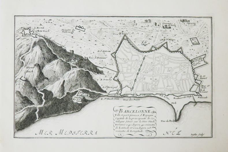
FER (Nicolas de).
[BARCELONE] Barcelonne ville et port fameux d'Espagne.
[1690-1695]. 166 x 270 mm.
Bookseller reference : LBW-4822
|
|
|
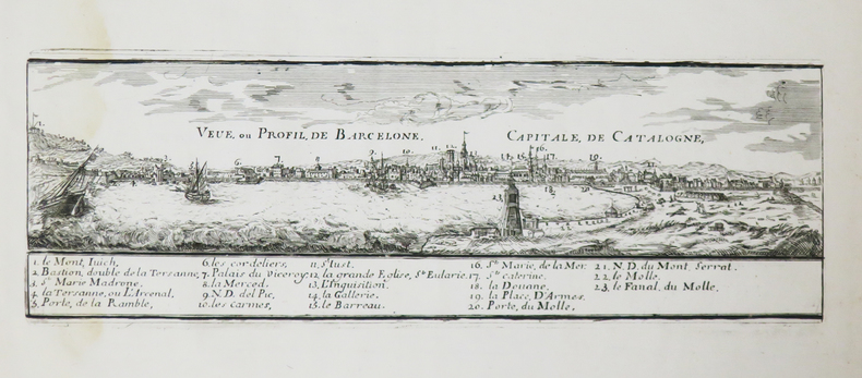
FER (Nicolas de).
[BARCELONE] Veue, ou profil, de Barcelone, capitale de Catalogne.
[1690-1695]. 93 x 288 mm.
Bookseller reference : LBW-4836
|
|
|
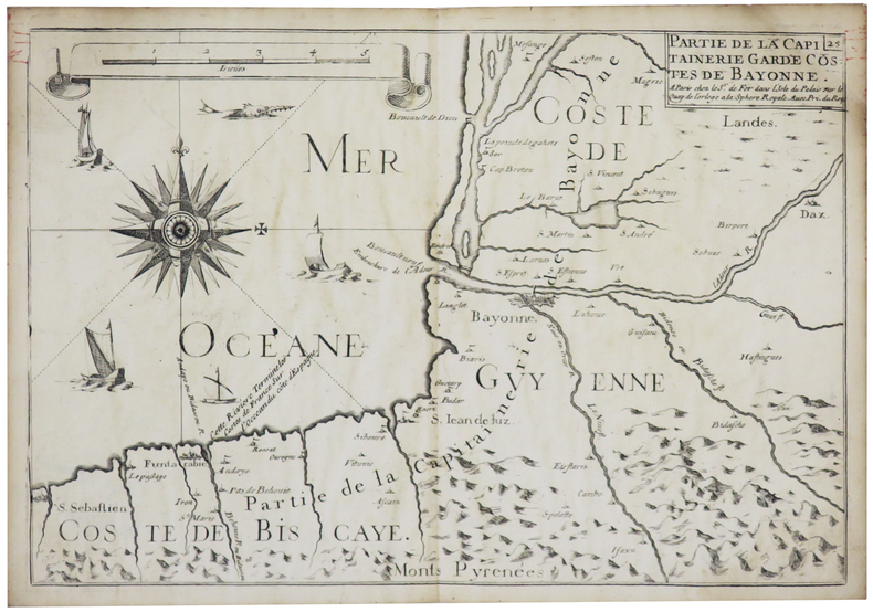
FER (Nicolas de).
[BAYONNE] Partie de la capitainerie garde costes de Bayonne.
Paris, Sr. de Fer, [1690]. 224 x 328 mm.
Bookseller reference : LBW-5664
|
|
|
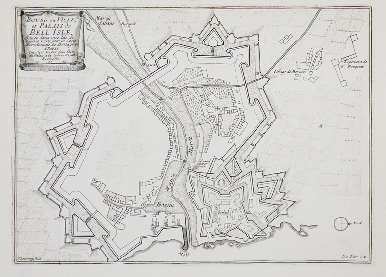
FER (Nicolas de).
[BELLE-ÎLE-en-MER] Bourg ou ville, et palais de Bell'Isle, située dans une isle de même nom, sur la coste méridionale de Bretagne.
Paris, Sr. de Fer, [1690-1695]. 214 x 299 mm.
Bookseller reference : LBW-4453
|
|
|
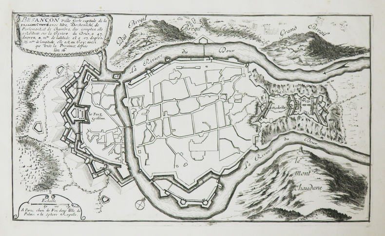
FER (Nicolas de).
[BESANÇON] Besançon ville forte capitale de la Franche Comté.
Paris, de Fer, [1690-1695].
Bookseller reference : LBW-4825
|
|
|
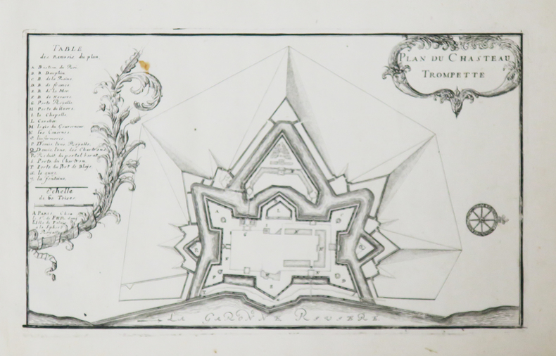
FER (Nicolas de).
[BORDEAUX] Plan du Chasteau Trompette.
Paris, Sr. de Fer, [1690-1695]. 162 x 276 mm.
Bookseller reference : LBW-4820
|
|
|
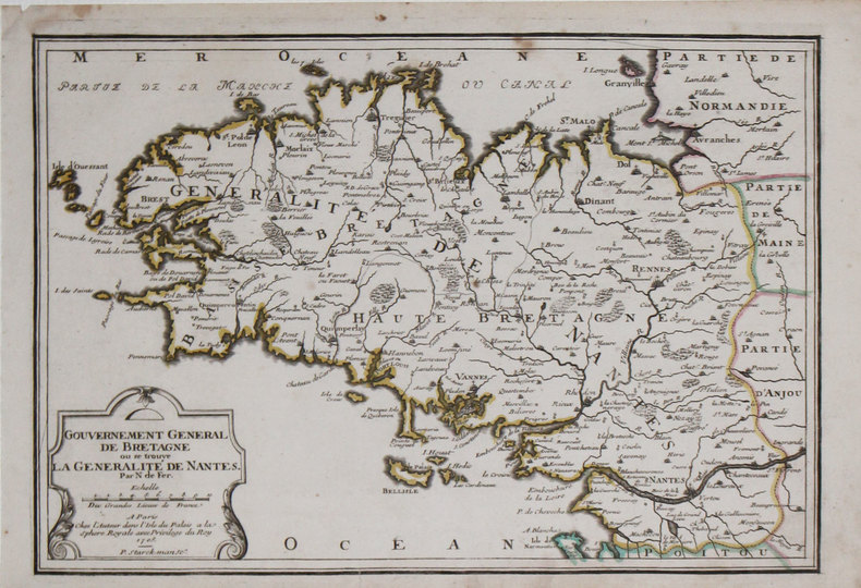
FER (Nicolas de).
[BRETAGNE] Gouvernement général de Bretagne où se trouve la généralité de Nantes.
Paris, chez l'auteur, 1705. 242 x 353 mm + feuillet de texte.
Bookseller reference : LBW-3188
|
|
|
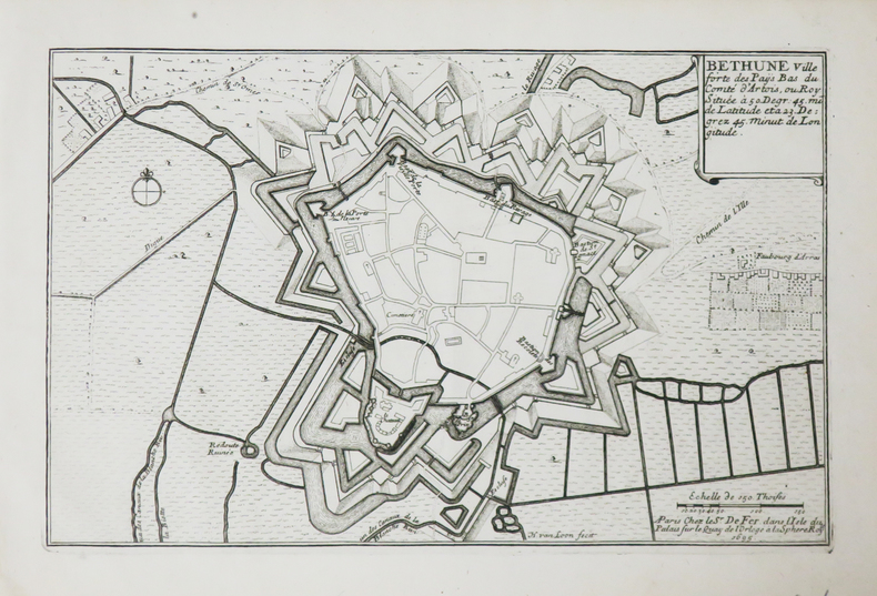
FER (Nicolas de).
[BÉTHUNE] Béthune ville forte des Paÿs Bas du comté d'Artois.
Paris, Sr. de Fer, 1695. 175 x 273 mm.
Bookseller reference : LBW-4835
|
|
|
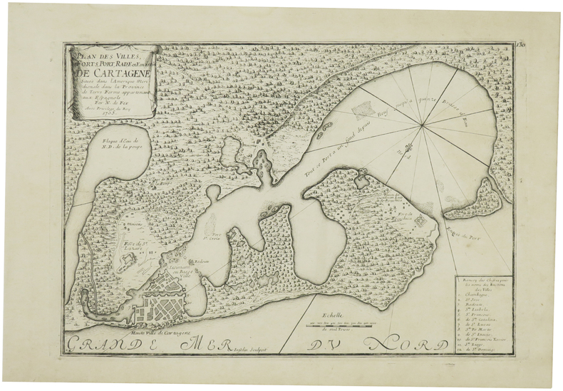
FER (Nicolas de).
[CARTHAGÈNE/COLOMBIE] Plan des villes, forts, port, rade et environs de Cartagène située dans l'Amérique méridionale dans la province de Terre Ferme appartenant aux Espagnols.
1705. 225 x 322 mm + feuillet de texte descriptif.
Bookseller reference : LBW-6085
|
|
|
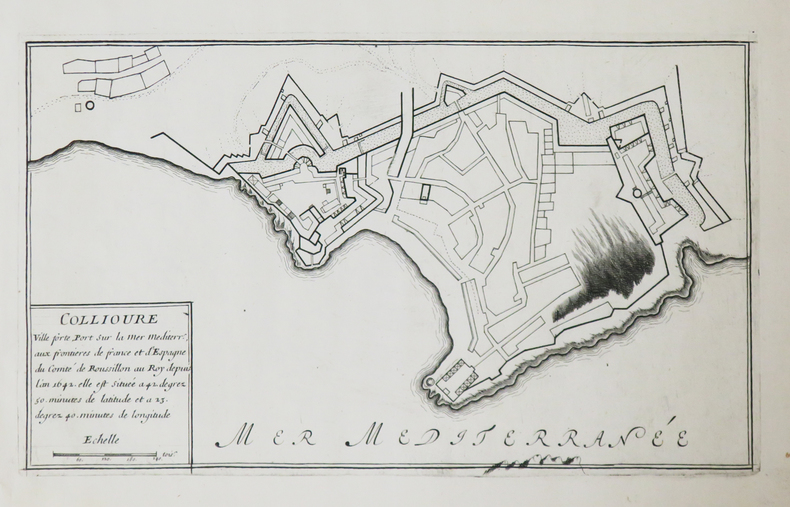
FER (Nicolas de).
[COLLIOURE] Collioure ville forte, port sur la mer Méditerranée.
[1690-1695]. 170 x 288 mm.
Bookseller reference : LBW-4823
|
|
|
FER (Nicolas de).
[ESTONIE] Plan de Narva.
Paris, 1705. 226 x 336 mm.
Bookseller reference : LBW-712
|
|
|
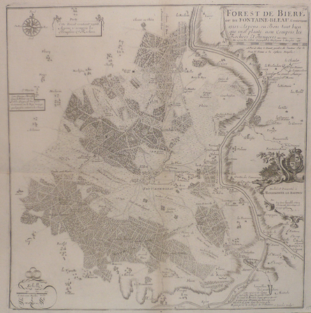
FER (Nicolas de).
[FONTAINEBLEAU] Forest de Bière ou de Fontaine-bleau contenant 13212 arpens en bois tant bien que mal planté non compris les rochers et bruyères.
Paris, G. Danet, 1705 [circa 1720]. 429 x 420 mm.
Bookseller reference : LBW03934
|
|
|
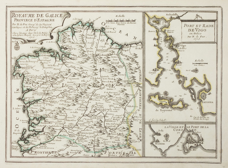
FER (Nicolas de).
[GALICE] Royaume de Galice province d'Espagne.
Paris, chez l'auteur, 1705. 236 x 327 mm.
Bookseller reference : LBW-2894
|
|
 Receive by email
 Download as PDF document
 RSS feed


