|
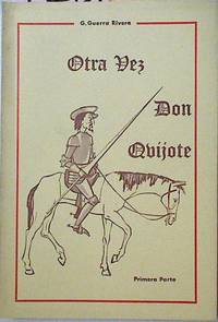
Guerra Rivera G
Otra Vez Don Quijote Primera Parte
1965. Tapa blanda. 2ª Mano. . . . . . Rustica 13x19 184p unknown
Bookseller reference : 12873
|
|
|
Guerra Lopez, Luis
Documentación histórica y literaria sobre la Virgen de Zorita
1987. Tapa blanda. 2ª Mano. . . . . . 223 p. 24x17 cm. tapa blanda unknown
Bookseller reference : 126229

|
|
|
United States. War Dept, United States. AdjutantGeneral's Office
Abstract of infantry tactics : including exercises and manoeuvres of light-infantry and riflemen : for use of militia of U.S 1830 Leather Bound
2021. Leather Bound. New. Size: 14.60 x 22.86 cms This book is available in 5 different Leather color without any extra cost. Explore More Options by Clicking on 'More Images' and Notify Us of Your Choice via Email within 24 hours of placing the order. Presenting an Exquisite Leather-Bound Edition expertly crafted by the prestigious organization “Rare Biblio” with Original Natural Leather that gracefully adorns the spine and corners. The allure continues with Golden Leaf Printing that adds a touch of elegance while Hand Embossing on the rounded spine lends an artistic flair. This masterpiece has been meticulously reprinted in 2021 utilizing the invaluable guidance of the original edition published many years ago in 1830. The contents of this book are presented in classic black and white. Its durability is ensured through a meticulous sewing binding technique enhancing its longevity. Imprinted on top-tier quality paper. A team of professionals has expertly processed each page delicately preserving its content without alteration. Due to the vintage nature of these books every page has been manually restored for legibility. However in certain instances occasional blurriness missing segments or faint black spots might persist. We sincerely hope for your understanding of the challenges we faced with these books. Recognizing their significance for readers seeking insight into our historical treasure we've diligently restored and reissued them. Our intention is to offer this valuable resource once again. We eagerly await your feedback hoping that you'll find it appealing and will generously share your thoughts and recommendations. Lang: - eng Vol:- Pages:- 202 If it is a multi-volume set then it is only a single volume. Product Disclaimer: Kindly be informed that owing to the inherent nature of leather as a natural material minor discolorations or textural variations may be perceptible. Explore the FOLIO EDITION 12x19 Inches: Available Upon Request. Please note:- Page Text Break hardcover
Bookseller reference : BIBLB000008184

|
|
|
Confederate States of America. War Dept
Army regulations adopted for the use of the army of the Confederate states in accordance with late acts of Congress. Revised from the army regulations of the old U.S. army 1857; retaining all that is essential for officers of the line 1861 Leather Bound
2013. Leather Bound. New. Size: 14.60 x 22.86 cms This book is available in 5 different Leather color without any extra cost. Explore More Options by Clicking on 'More Images' and Notify Us of Your Choice via Email within 24 hours of placing the order. Presenting an Exquisite Leather-Bound Edition expertly crafted by the prestigious organization “Rare Biblio” with Original Natural Leather that gracefully adorns the spine and corners. The allure continues with Golden Leaf Printing that adds a touch of elegance while Hand Embossing on the rounded spine lends an artistic flair. This masterpiece has been meticulously reprinted in 2013 utilizing the invaluable guidance of the original edition published many years ago in 1861. The contents of this book are presented in classic black and white. Its durability is ensured through a meticulous sewing binding technique enhancing its longevity. Imprinted on top-tier quality paper. A team of professionals has expertly processed each page delicately preserving its content without alteration. Due to the vintage nature of these books every page has been manually restored for legibility. However in certain instances occasional blurriness missing segments or faint black spots might persist. We sincerely hope for your understanding of the challenges we faced with these books. Recognizing their significance for readers seeking insight into our historical treasure we've diligently restored and reissued them. Our intention is to offer this valuable resource once again. We eagerly await your feedback hoping that you'll find it appealing and will generously share your thoughts and recommendations. Lang: - English Vol:- Pages:- 203 If it is a multi-volume set then it is only a single volume. Product Disclaimer: Kindly be informed that owing to the inherent nature of leather as a natural material minor discolorations or textural variations may be perceptible. Explore the FOLIO EDITION 12x19 Inches: Available Upon Request. hardcover
Bookseller reference : BIBLB000962153

|
|
|
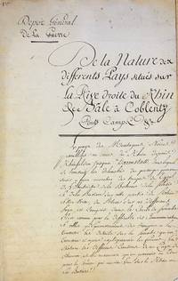
Depot General de la Guerre
De la Nature des differents Pays situés sur la Rive droite du Rhin de Bâle à Coblentz. Ponts Camp. etc.
France late 18th century. Manuscript on paper. Text in French written in a neat hand. Sewn. Occasional spotting. Overall in fine condition. Manuscript on paper. Text in French written in a neat hand. Sewn. ff. 46 last blank. <p><br /> An important 18th-century manuscript from the Dépôt de la Guerre providing a strategic analysis of the right bank of the Upper and Middle Rhine used for military reconnaissance and planning.<br /> <p><p><br /> This manuscript produced by the Dépôt Général de la Guerre presents a detailed strategic analysis of the right bank of the Rhine from Basel to Koblenz. The Dépôt de la Guerre established in 1688 was the principal institution responsible for French military intelligence cartography and strategic planning. It played a crucial role in gathering and disseminating geographic and strategic data to support military operations. This manuscript is a testament to that work offering valuable insights into potential military routes positions and logistical considerations along the Upper and Middle Rhine—a region of significant strategic importance.<br /> <p><p><br /> The manuscript is divided into four sections each providing specific strategic information.<br /> <p><p><br /> De la Nature des differents Pays situés sur la Rive droite du Rhin de Bâle à Coblentz: The main section offers a comprehensive overview of the nature and strategic value of regions on the right bank of the Rhine from Basel to Koblenz. It discusses the terrain routes suitable for army movements locations favorable for establishing camps and available agricultural resources. Regions such as Baden the Palatinate Worms Mainz Württemberg and others are examined from a military perspective.<br /> <p><p><br /> Positions militaires sur la Rive droit du Rhin de Bale à Coblentz: This section focuses on analyzing potential military positions along the right bank of the Rhine identifying defensible locations natural barriers and strategic points for effectively deploying troops and artillery.<br /> <p><p><br /> Indication des principaux lieux où il seroit possible à l’ennemi de Jetter des Ponts sur la Rive droite du Rhin de Bâle à Coblentz: Identifies key locations along the right bank where an enemy might construct bridges to cross the Rhine highlighting strategic points that could be critical for defense or control to prevent such crossings.<br /> <p><p><br /> Indications des différens lieux entre Bale et Philisbourg où l'on pourrait Jetter des Ponts sur la Rive Gauche du Rhin pour se porter dans les Pays situés sur sa Rive Droite: Discusses potential sites between Basel and Philippsburg on the left bank of the Rhine where bridges could be established to launch operations onto the right bank. This section is essential for planning offensive maneuvers or controlling river crossings.<br /> <p><p><br /> To the best of our knowledge this manuscript was never published in print and was presumably circulated only in a few copies this one bears the inscription “1er†on the first leaf making it a rare and significant example of 18th-century military reconnaissance and planning. Comparable manuscripts are found in the archives of the Service Historique de la Défense such as the Exposé sommaire de la nature des différents pays situés sur la rive droite du Rhin de Bâle à Coblenz entre les montagnes Noires et le Rhin which includes additional reconnaissance reports from 1730 and 1743 1 M 1504. Similarly another version of the Exposé sommaire appears in Louis Tuetey's Catalogue général des manuscrits des bibliothèques publiques de France: Archives de la guerre no. 1941 underscoring the careful documentation and strategic importance of the Rhine region by the Dépôt de la Guerre.<br /> <p><p><br /> Koblenz located at the confluence of the Rhine and Moselle rivers was a critical strategic point during this period. It was occupied by French forces from 1794 to 1814 serving as a key administrative and logistical hub during the French Revolutionary and Napoleonic Wars. The kind of intelligence contained in this manuscript would have been invaluable for controlling the Middle Rhine region and planning military operations.<br /> <p><p><br /> Although this manuscript predates the Napoleonic Wars its detailed geographic and strategic insights regarding potential military positions river crossings and logistical planning would have been highly useful to French commanders. The systematic efforts of the Dépôt de la Guerre in compiling such data were essential for shaping military strategies and ensuring effective operations along the Rhine and beyond. This manuscript remains a significant historical resource for understanding the military geography and strategy of the late 18th century.<br /> <p>. unknown
Bookseller reference : 3342
|
|
|
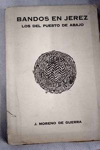
Moreno de Guerra y Alonso, Juan
Bandos en Jerez: los del puesto de abajo
Madrid. 1929. Paperback. Cubierta deslucida. . intoso en algunas páginas . Good. 22 cm. 143 p. Encuadernación en tapa blanda de editorial. Estudio social y genealógico de la Edad Media en las fronteras del reino moro de Granada . Cubierta deslucida. . intoso en algunas páginas . Historia.93 93 paperback
Bookseller reference : 2674037

|
|
|
Moreno de Guerra y Alonso, Juan
Bandos en Jerez: los del puesto de abajo
Madrid. 1929. Paperback. Cubierta deslucida. . intoso en algunas páginas . Good. 22 cm. 143 p. Encuadernación en tapa blanda de editorial. Estudio social y genealógico de la Edad Media en las fronteras del reino moro de Granada . Cubierta deslucida. . intoso en algunas páginas . Historia.93 93 paperback
Bookseller reference : 2674039
|
|
|
Moreno de Guerra y Alonso, Juan
Bandos en Jerez: los del puesto de abajo
Madrid. 1929. Paperback. Cubierta deslucida. . intoso en algunas páginas . Good. 22 cm. 143 p. Encuadernación en tapa blanda de editorial. Estudio social y genealógico de la Edad Media en las fronteras del reino moro de Granada . Cubierta deslucida. . intoso en algunas páginas . Historia.93 93 paperback
Bookseller reference : 2674038

|
|
|
Guerra de la Vega, Ramon
El reinado de Alfonso XIII: Arte arquitectura y fotografÃa
Madrid. 2018. Paperback. Good. 24 páginas. Encuadernación en tapa blanda de editorial. ISBN: M 214412018 Depósito legal: M 21441-2018 AstronomÃa. AstrofÃsica. Investigación espacial. Geodesia.52 52 Libros infantiles y juveniles.087.5 087.5 Historia.93 93 paperback
Bookseller reference : 2938043

|
|
|
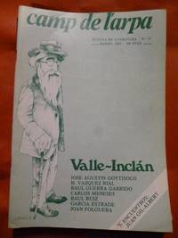
(Valle-Inclan) Valle Inclan Jose Agustin Goytisolo, H. Vazquez Rial, Garcia Estrade, Raul Guerra Garrido, Carlos Meneses, Raul R
CAMP DE L'ARPA. Revista de Literatura Nº. 97. Valle-Inclán
Barcelona 1982. Camisas. 18x27. ilus. unknown
Bookseller reference : 48.349
|
|
|
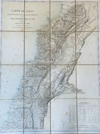
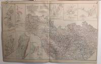
Gelis Charles; Schieble Erhard; Depot De La Guerre
Lebanon Carte du Liban d'après les reconnaissances de la Brigade Topographique du Corps Expéditionnaire de Syrie en 1860–1861. Dressée au Dépôt de la Guerre Étant Directeur Le Général Blondel Sous Le Ministère de S. E. Le Maréchal Comte Randon 1862
Paris: Imp. Lemercier rue de Seine 57. Gravée per Erhard Schièble rue Bonaparte 42 1862. Color lithograph map in 16 sections mounted with linen. Bookseller’s vignette on verso A. Corion Succ.r de H. Dorlin Paris. Map somewhat tanned with few stains and light foxing. Linen tanned worn at the two outer foldings of the upper section. Overall in very good condition. Color lithograph map in 16 sections mounted with linen. Bookseller’s vignette on verso A. Corion Succ.r de H. Dorlin Paris. 74 × 96.5 cm. First edition of the most important map in the history of Lebanon the first scientific map of the country.<br /> A highly detailed separately issued large-format lithograph scientific map of Lebanon “based on surveys conducted by French military topographers during their Lebanon-Syria Expedition of 1860–1861. This map defined the notion of ‘Greater Lebanon’ the basis for the creation of modern Lebanon in the wake of the 1919 Paris Peace Conference. Lebanon was at that time part of the Ottoman Empire. The cartographic part of the mission was headed by Captain Charles Gelis who led teams that made advanced systematic trigonometric surveys of the countryside representing the first time that Lebanon had ever been accurately topographically mapped. Map extends into parts of Israel and Syria. Showing cities towns villages Christian monasteries mosques fortified places windmills aqueducts landmarks roads rivers mountains districts which are labeled with their names. Includes Table of population. Relief shown by hachures formlines and spot heights.†David Rumsey Map Collection The statistical table in the bottom right gives the population of the major towns and cities in Lebanon by religion. <br /> Scarce no records on RBH. Imp. Lemercier, rue de Seine 57. (Gravée per Erhard Schièble rue Bonaparte 42) unknown
Bookseller reference : 2737
|
|
|
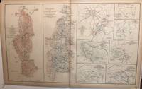
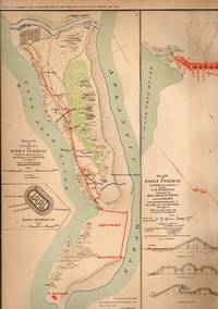
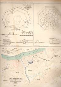
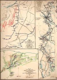
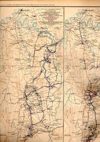
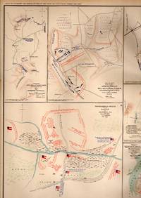
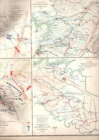
United States War Department
Plate #XCII 40: "Map of Port of South Side of James River VA. & Battlefield of Chancellorsville Va.
Washington D.C.: Government Printing Office 1891. 1st . No Binding. Very Good. 18" x 29. Handcolored. 1st thus printing; Plate #XCII 40 from the Atlas to Accompany the Official Records of the Union & Confederate Armies 1861-1865.CIVIL WAR Battles 2 Maps !: Preliminary Reconnaissance Map of South Side of James River Virginia & 2. Battle-field of Chancellorsville Virginia.Single sheet suitable for framing <br/> <br/> Government Printing Office unknown
Bookseller reference : 095324
|
|
|
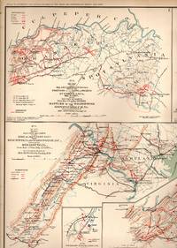
United States War Department
Plate #XCI 41: 5 Maps of Battle Positions: Spotsylvania County Virginia; Hanover Junctin Virginia; Goldsborough North Carolina Boyd's Neck Honey Hill Devaux's Neck South Carolina & Spanish Fort Defenses
Washington D.C.: Government Printing Office 1891. 1st . No Binding. Very Good. 18" x 29. Handcolored. 1st thus printing; Plate #XCI 41 from the Atlas to Accompany the Official Records of the Union & Confederate Armies 1861-1865. 5 Maps of Battle Positions: Spotsylvania County Virginia; Hanover Junctin Virginia; Goldsborough North Carolina Boyd's Neck Honey Hill Devaux's Neck South Carolina & Spanish Fort Defenses.Single sheet suitable for framing <br/> <br/> Government Printing Office unknown
Bookseller reference : 095323
|
|
|
United States War Department
Plate #XCIV 44: "9 Battlefield Maps: Defenses in the Alleghanies; Vally of Virginias from Sstaunton to Winchester; Frederick and Monacacy River Maryland and others.
Washington D.C.: Government Printing Office 1891. 1st . No Binding. Very Good. 18" x 29. Handcolored. 1st thus printing; Plate #XCIV 44 from the Atlas to Accompany the Official Records of the Union & Confederate Armies 1861-1865.CIVIL WAR Battles 9 Maps: Defenses in the Alleghanies; 2.Valley of Virginias from Staunton to Winchester; 3.Frederick and Monacacy River Maryland; 4. Union Hospitals in the Battle of the wilderness; 5. Union Hosptials in Spotssylvania Court House VA. 6. Union Hospitals in Cold Harbor VA; 7. Skirmish At Salinville Ohio; 89: Fifth Army Corps Position .Single sheet suitable for framing <br/> <br/> Government Printing Office unknown
Bookseller reference : 095325
|
|
|
United States War Department
MAP: Plate #XCV 45: "2 Maps Of the Battle of Gettysburg; 1 Map of Gaps in the Mountains from Winter's Gap Tennessee to Louisa Kentucky
Washington D.C.: Government Printing Office 1891. 1st . No Binding. Very Good. 18" x 29. Handcolored. 1st thus printing; Plate #XCV 45 from the Atlas to Accompany the Official Records of the Union & Confederate Armies 1861-1865.CIVIL WAR Battles 3 Maps: 1-2 Battle of Gettysbugy; 1 Gaps in the Mountains from Winter's Gap Tennessee to Louisa Kentuck.Single sheet suitable for framing <br/> <br/> Government Printing Office unknown
Bookseller reference : 095326
|
|
|
United States War Department
MAP: Map of the Vicinity of Eichmond VA. And Part of the Peninsula 1864
Washington D.C.: Government Printing Office 1891. No Binding. Very Good. 18" x 29. Handcolored. Plate #XGII. From the Atlas to Accompany the Official Records of the Union & Confederate Armies 1861-1865 with inset of part of Hannover County & part of New Kent county. <br/> <br/> Government Printing Office unknown
Bookseller reference : 093608
|
|
|
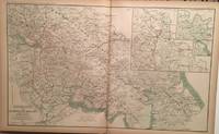
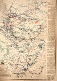
United States War Department
MAP: Campaign Maps: Position of 20th Army Corps on March from Atlantsw GA to Savannah GA with dates and Defenses. 18 maps 1 sheet
Washington D.C.: Government Printing Office 1891. 1st Edition . No Binding. Very Good. 18" x 29. Handcolored. Plate LXXI.From the Atlas to Accompany the Official Records of the Union & Confederate Armies 1861-1865. additional maps: Map of the defenses of the City of Mobile Alabama rebel line of works at Blakely Alabama Expedition from messenger's ferry toward canton Mississippi & Positon occupied by troops French's division at Chattahoochee river; margins reinforced on reverse lite chipping.Single sheet suitable for framing 2 scans=almost full image <br/> <br/> Government Printing Office unknown
Bookseller reference : 090440
|
|
|
United States War Department
MAP: "Campaign Maps: Savannahm GA to Goldsborough & Goldsborough to Washington D.C. & Operations About Bottom's Bridge VA.". 17 maps 1 sheet
Washington D.C.: Government Printing Office 1891. No Binding. Very Good. 18" x 29. Handcolored. Plate LXXXVI.From the Atlas to Accompany the Official Records of the Union & Confederate Armies 1861-1865. 17 maps first printing after the Civil War.Single sheet suitable for framing 2 scans=almost full image <br/> <br/> Government Printing Office unknown
Bookseller reference : 090441

|
|
|
Shadid, WAR
Islam in Dutch Society
Peeters Publishers 1992. paperback. New. 9x5x0. Peeters Publishers paperback
Bookseller reference : 105361 ISBN : 9024230470 9789024230471
|
|
|
Guerra, Ana Fernandez
Applied linguistics for English-Spanish translation
Logos Verlag Berlin 2014. paperback. New. 92x8x128. Logos Verlag Berlin paperback
Bookseller reference : 546091 ISBN : 3832537783 9783832537784

|
|
|
Shadid, WAR
Political Participation and Identities of Muslims in Non-Muslim States
Peeters Publishers 1996. paperback. New. 96x12x142. Peeters Publishers paperback
Bookseller reference : 102661 ISBN : 9039006113 9789039006115
|
|
|
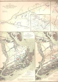
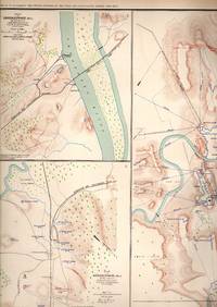
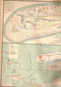
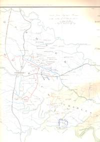
United States War Department
MAP: 5 Section Maps including White House to Harrison's Landing Virginia; Seigne of Yorkstown Williamsburg to White House and 2 of Mulberry Island Virginia
Washington D.C.: Government Printing Office 1891. 1st . No Binding. Very Good. 18" x 29. Colored Map. 1swt thus edition printing; Plate XIX.From the Atlas to Accompany the Official Records of the Union and Confederate Armies 1861-1865 White House to Harrison's Landing Virginia; Seigne of Yorkstown Williamsburg to White House and 2 of Mulberry Island Virginia.single sheet lovely and suitable for framing <br/> <br/> Government Printing Office unknown
Bookseller reference : 031849
|
|
|
United States War Department
MAP: 3 Section Maps of the Battle Plan and Final Attack of Fort Fisher North Carolina
Washington D.C.: Government Printing Office 1891. 1st . No Binding. Very Good. 18" x 29. Colored Map. First Thus printing; Plate LXXV.From the Atlas to Accompany the Official Records of the Union and Confederate Armies 1861-1865.single sheet lovely and suitable for framing 2 scans = almost full image <br/> <br/> Government Printing Office unknown
Bookseller reference : 031843
|
|
|
United States War Department
MAP:10 Section Map Including Engagement of Secessinville James Island South Carolina; Catlett's Station the Grand Lake Region and Groveton
Washington D.C.: Government Printing Office 1891. 1st . No Binding. Very Good. 18" x 29. Colored Map. First Thus printing; Plate #XXIII 23 from the Atlas to Accompany the Official Records of the Union and Confederate Armies 1861-1865Engagement of Secessinville James Island South Carolina; Catlett's Station the Grand Lake Region and Groveton.single sheet suitable for framing <br/> <br/> Government Printing Office unknown
Bookseller reference : 059220
|
|
|
United States War Department
MAP: 5 Section Maps of the Routes of a Raid Made By Cavalry Under P.H. Sherman Including Central Virginia Dinwiddie VA; Montgomery Alabama Columbus Georgia & Ebenezer Church Alabama
Washington D.C.: Government Printing Office 1891. 1st . No Binding. Very Good. 18" x 29. Colored Map. Plate LXXIV.From the Atlas to Accompany the Official Records of the Union and Confederate Armies 1861-1865 Routes of a Raid Made By Cavalry Under P.H. Sherman Including Central Virginia Dinwiddie VA; Montgomery Alabama Columbus Georgia & Ebenezer Church Alabama.single sheet lovely and suitable for framing 2 scans = almost full image <br/> <br/> Government Printing Office unknown
Bookseller reference : 031847
|
|
|
United States War Department
MAP: 3 Section Map Including Military Reconnaissance Vicinity of Gauley Bridge Department of Western Virginia; Sketch of the Country About Somerset Kentucky & Map of the Battlefield of Carnifix Ferry Gauley River West Virgiinia
Washington D.C.: Government Printing Office 1891. No Binding. Very Good. 18" x 29. Colored Map. Plate #IX 9 from the Atlas to Accompany the Official Records of the Union and Confederate Armies 1861-1865.single sheet LOVELY and suitable for framing 2 scans = almost full image <br/> <br/> Government Printing Office unknown
Bookseller reference : 059231
|
|
|
United States War Department
MAP: 6 Maps--Fort Pickering Memphis Tennessee Fort Donelson Tennessee Fort at Hyde's Ferry Redoubt Fort Harker Nashville Tennessee
Washington D.C.: Government Printing Office 1891. 1st 1st Printing. No Binding. Near Fine. 18" x 29. Plate #CXIV From the Atlas to Accompany the Official Records of the Union & Confederate Armies 1861-1865. Lovely and suitable for framing 2 scans = almost full image <br/> <br/> Government Printing Office unknown
Bookseller reference : 011723
|
|
|
United States War Department
MAP: 7 Section Map Including Decherd Jasper Tullahoma Chattanoog Duckport and Shelbyville Tennessee
Washington D.C.: Government Printing Office 1891. 1st . No Binding. Very Good. 18" x 29. Colored Map. 1st thus edition; Plate #XXXV 35 from the Atlas to Accompany the Official Records of the Union and Confederate Armies 1861-1865 Including Decherd Jasper Tullahoma Chattanoog Duckport and Shelbyville Tennessee. single sheet suitable for framing 2 scans=almost full image <br/> <br/> Government Printing Office unknown
Bookseller reference : 059230
|
|
|
United States War Department
MAP: 10 maps-inc Federal Point Fort Fisher NC; Petersburg Deep Bottom Harrison's Landing and Crows Nest Virginia--1864
Washington D.C.: Government Printing Office 1891. No Binding. Very Good. 18" x 29. Handcolored. Plae #LXVII 67 from the Atlas to Accompany the Official Records of the Union & Confederate Armies 1861-1865.Single sheet suitable for framing 2 scans = almost full image <br/> <br/> Government Printing Office unknown
Bookseller reference : 012195
|
|
|
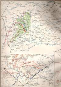
United States War Department Corps of Engineers
MAP: "Chart of Grand Island and Its Approaches LAKE SUPERIOR
Washington D.C.: Government Printing Office 1905. No Binding. Near Fine. 16" x 20. b/w Map. facsmile reproduction of the original 1905 navigational map of the Munising Bay Upper Peninsula Michigan; and the area around Grand Island 2 scans=full image <br/> <br/> Government Printing Office unknown
Bookseller reference : 065465

|
|
|
United States War Department
MAP: 6 Section Map Including Battle of Murfreesborough Battle of Fredericksburg Tullahoma Stone's River and Thompson's Hill
Washington D.C.: Government Printing Office 1891. 1st . No Binding. Very Good. 18" x 29. Colored Map. Plate #XXXI 31 from the Atlas to Accompany the Official Records of the Union and Confederate Armies 1861-1865 Battle of Murfreesborough Battle of Fredericksburg Tullahoma Stone's River and Thompson's Hill. 2 scans = almost full image <br/> <br/> Government Printing Office unknown
Bookseller reference : 059226
|
|
|
United States War Department
MAP: 7 Section Map Including Maps Petersburg the Carolinas; Bentonville North Carolina Pea Ridge Arkansas Averysborough North Carolina and Spanish Fort Mobile Bay
Washington D.C.: Government Printing Office 1891. 1st . No Binding. Very Good. 18" x 29. Colored Map. 1st thus; Plate LXXIX.From the Atlas to Accompany the Official Records of the Union and Confederate Armies 1861-1865 etersburg the Carolinas; Bentonville North Carolina Pea Ridge Arkansas Averysborough North Carolina and Spanish Fort Mobile Bay.single sheet lovely and suitable for framing 2 scans=almost full image <br/> <br/> Government Printing Office unknown
Bookseller reference : 031833
|
|
|
United States War Department
MAP: 6 Section Map Including Maps of Petersburg Chester Station & Manchester to Amelia Court-House Virginia High Bridge & Farmville Virginia Appomattox Court-House Corinth Mississippi Pittesurgh Tennessee and the Petersburg Mine Explosion
Washington D.C.: Government Printing Office 1891. 1st . No Binding. Very Good. 18" x 29. Colored Map. 1st thus; Plate LXXVIII.From the Atlas to Accompany the Official Records of the Union and Confederate Armies 1861-1865 Maps of Petersburg Chester Station & Manchester to Amelia Court-House Virginia High Bridge & Farmville Virginia Appomattox Court-House Corinth Mississippi Pittesurgh Tennessee and the Petersburg Mine Explosion.single sheet lovely and suitable for framing 2 scans = almost full image <br/> <br/> Government Printing Office unknown
Bookseller reference : 031834

|
|
|
United States War Department
MAP: 8 Section Map Including Battle-field of Bristoe Missionaary Ridge Tennessee & Orange County Virginia
Washington D.C.: Government Printing Office 1891. 1st . No Binding. Very Good. 18" x 29. Colored Map. Plate #XLV 45 from the Atlas to Accompany the Official Records of the Union and Confederate Armies 1861-1865 Including Battle-field of Bristoe Missionaary Ridge Tennessee & Orange County Virginia.single sheet suitable from framing; 1s thus edition; 2 scans = almost full image <br/> <br/> Government Printing Office unknown
Bookseller reference : 059237
|
|
|
United States War Department
MAP: 6 Maps: Defenses of Mason Georgia; Battlefield of Chancellorsville VA; Battle of Cedar Moutain VA; Battle of Wilson's Green Missouri Batttles of Buckingham and Appomattox VA; Etc
Washington D.C.: Government Printing Office 1891. No Binding. Very Good. 18" x 29. Colored. Plate CXXXV From the Atlas to Accompany the Official Records of the Union & Confederate Armies 1861-1865.Defenses of Mason Georgia; Battlefield of Chancellorsville VA; Battle of Cedar Moutain VA; Battle of Wilson's Green Missouri Batttles of Buckingham and Appomattox VA; Etc ; Lovely and suitable for framing 2 images captures most of the item <br/> <br/> Government Printing Office unknown
Bookseller reference : 021269
|
|
|
United States War Department
MAP: 4 Maps & 2 Sketches: Topographical Sketch of Fortress Rosecrans Near Murfreesborough Tenn.; Etc
Washington D.C.: Government Printing Office 1891. 1st 1st Printing. No Binding. Very Good. 18" x 29. Handcolored. Plate #CXII Topographical Sketch of Fortress Rosecrans Murfreesborough Tennessee Stevenson Alabama Fort Little Fort Crutchfield from the Atlas to Accompany the Official Records of the Union & Confederate Armies 1861-1865. single sheet suitable for framing; 1st printing of this atlas; 2 scans = almost full image <br/> <br/> Government Printing Office unknown
Bookseller reference : 000864
|
|
|
United States War Department
MAP: 5 Section Map Including Upper Potomac from McCoy's Ferry to Conrad's Ferry Cedar Creek Virginia Savannah Georgia
Washington D.C.: Government Printing Office 1891. No Binding. Very Good. 18" x 29. Colored Map. Plate no. LXIX.From the Atlas to Accompany the Official Records of the Union and Confederate Armies 1861-1865 Including Upper Potomac from McCoy's Ferry to Conrad's Ferry Cedar Creek Virginia Savannah Georgia.2 scans = amost full item image <br/> <br/> Government Printing Office unknown
Bookseller reference : 059249
|
|
|
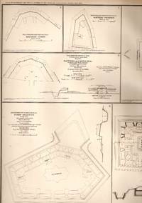
United States War Department
MAP: Defenses of Nashville Tennessee.Plate CXIII From the Atlas to Accompany the Official Records of the Union & Confederate Armies 1861-1865
Washington D.C.: Government Printing Office 1891. 1st . No Binding. Very Good. 18" x 29. b/w Map. Plate #CXIII.from the Atlas to Accompany the Official Records of the Union & Confederate Armies 1861-1865 9 diagrams/sketches of the defenses of Nashville chattanooga capitol Fort W.D. Whippple Redoubt Fort Dan McCook Fort Morton Casino Hill etc.single sheet suitable for framing <br/> <br/> Government Printing Office unknown
Bookseller reference : 068282
|
|
|
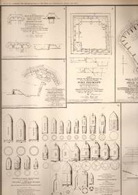
United States War Department
MAP: 8 Plates with Plays for Mobile Defenses for Fort Sidney Johnson Fort Prescott Etc.
Washington D.C.: Government Printing Office 1891. 1st Edition . No Binding. Very Good. 18" x 29. Handcolored. Plate CVII 57 from the Atlas to Accompany the Official Records of the Union & Confederate Armies 1861-1865 Mobile Defenses for Fort Sidney Johnson Fort Prescott Etc.Single sheet suitable for framing 2 scans = almost full image <br/> <br/> Government Printing Office unknown
Bookseller reference : 012154
|
|
|
United States War Department
MAP: 5 Section Map Including Headyville Bradyville and Woodburg Tennessee Shelbyville Etc
Washington D.C.: Government Printing Office 1891. 1st . No Binding. Very Good. 18" x 29. Colored Map. First Thus printing; Plate# XXXIV From the Atlas to Accompany the Official Records of the Union and Confederate Armies 1861-1865 Including Headyville Bradyville and Woodburg Tennessee Shelbyville Etc.2 scans = almost full image <br/> <br/> Government Printing Office unknown
Bookseller reference : 059229
|
|
|
United States War Department
MAP: 15 maps and sketches of 16th & 17th Army positions 1864
Washington D.C.: Government Printing Office 1891. 1st . No Binding. Near Fine. 18" x 29. Colored & b&w Photos. Plate #LXI 60 from the Atlas to Accompany the Official Records of the Union & Confederate Armies 1861-1865 16th & 17th Army positions 1864.Single sheet suitable for framing <br/> <br/> Government Printing Office unknown
Bookseller reference : 020440
|
|
|
United States War Department
MAP: 8 Section Map Including Battle of Fredericksburg Virginia Fort Morgan Alabama Mobile Bay Stubbs Plantation and Bruce's Cross Roads Mississippi Snake Creek Gap Georgia & Mechanicsville and Cold Harbor Virginia
Washington D.C.: Government Printing Office 1891. 1st . No Binding. Very Good. 18" x 29. Colored Map. 1st thus edition printing; Plate #LXIII 63 From the Atlas to Accompany the Official Records of the Union and Confederate Armies 1861-1865 Including Battle of Fredericksburg Virginia Fort Morgan Alabama Mobile Bay Stubbs Plantation and Bruce's Cross Roads Mississippi Snake Creek Gap Georgia & Mechanicsville and Cold Harbor Virginia.Single sheet suitable for framing 2 scans = almost full view <br/> <br/> Government Printing Office unknown
Bookseller reference : 059247
|
|
|
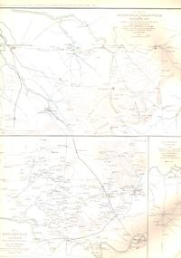
United States War Department
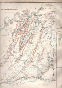
MAP: 5 Section Map Including The Chickamauga Campaigh & Approaches and Defenses of Knoxville Tennessee
Washington D.C.: Government Printing Office 1891. 1st . No Binding. Very Good. 18" x 29. Colored Map. 1st thus printing; Plate #XLVIII from the Atlas to Accompany the Official Records of the Union and Confederate Armies 1861-1865 Including The Chickamauga Campaigh & Approaches and Defenses of Knoxville Tennessee .single sheet suitable for framing 2 scans = almost a full image of item <br/> <br/> Government Printing Office unknown
Bookseller reference : 059240
|
|
|
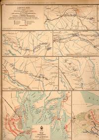
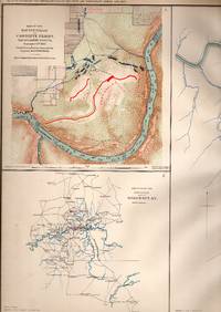
United States War Department
MAP: Plate LIX 59: 3rd Epoch of the Atlanta Campaign May 5-Sept 4 1864
Washington D.C.: Government Printing Office 1891. 1st . No Binding. Very Good. 18" x 29. Colored. single sheet double page suitable for framing; From the Atlas to Accompany the Official Records of the Union & confederate Armies 1861-1865. 3rd Epoch of the Atlanta Campaign May 5-Sept 4 1864 marginal disress and repair at top left corner; stain on reverse <br/> <br/> Government Printing Office unknown
Bookseller reference : 021273
|
|
|
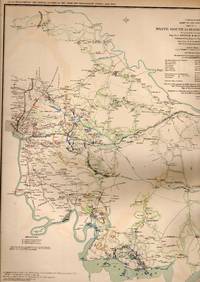
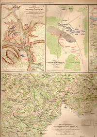
United States War Department
MAP:7 Sections Including Cavalry Brigade Cedar Mountain Bull Run Manassas Virginia Etc
Washington D.C.: Government Printing Office 1891. 1st . No Binding. Very Good. 18" x 29. Colored Map. 1st thus printing; Plate #XXII 22 from the Atlas to Accompany the Official Records of the Union and Confederate Armies 1861-1865.Including Cavalry Brigade Cedar Mountain Bull Run Manassas Virginia Etc. single sheet suitable for framing 2 scans = almost full image <br/> <br/> Government Printing Office unknown
Bookseller reference : 059252
|
|
|
United States War Department
MAP: 7 Battlefield Maps: Battles of the Wilderness Spotsylvania Strasburg Caroline County gaines' Mills to Lynchburg Hanover Junction Etc
Washington D.C.: Government Printing Office 1891. 1st . No Binding. Very Good. 18" x 29. Colored Map. First Thus edition; Plate LXXXI From the Atlas to Accompany the Official Records of the Union & Confederate Armies 1861-1865 Battles of the Wilderness Spotsylvania Strasburg Caroline County gaines' Mills to Lynchburg Hanover Junction Etc. ; Lovely and suitable for framing 2 scans=almost full image <br/> <br/> Government Printing Office unknown
Bookseller reference : 031828
|
|
|
United States War Department
MAP: 8 Section Map Including the positions of the Army of Tennesee Petersburg Virginia & the Atlanta Campaign
Washington D.C.: Government Printing Office 1891. No Binding. Very Good. 18" x 29. Colored Map. From the Atlas to Accompany the Official Records of the Union and Confederate Armies 1861-1865 Including the positions of the Army of Tennesee Petersburg Virginia & the Atlanta Campaign.Lite marginal evidence of insect 2 scans = almost full image <br/> <br/> Government Printing Office unknown
Bookseller reference : 059246

|
|
|
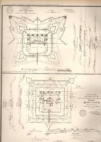
United States War Department
MAP: Rebel Lines: Mobile Defenses .Plate CVIII From the Atlas to Accompany the Official Records of the Union & Confederate Armies 1861-1865
Washington D.C.: Government Printing Office 1891. 1st . No Binding. Very Good. 18" x 29. b/w Map. 4 diagrams/sketches of the Rebel lines: Mobile defenses of Lunette Fort G.H. & I. Fort Mouton and Fort Jeb Stuart 2 scans = almost full imge first printing of this edition <br/> <br/> Government Printing Office unknown
Bookseller reference : 068283
|
|
|
United States War Department
MAP: 4 Section Map Including Artillery Positions Of the Army of the Potomac Reconnaissance Beyond the Chickahominy Petersburg Virginia
Washington D.C.: Government Printing Office 1891. 1st . No Binding. Very Good. 18" x 29. Colored Map. First Thus printing; Plate #LXIV 64 from the Atlas to Accompany the Official Records of the Union and Confederate Armies 1861-1865 Including Artillery Positions Of the Army of the Potomac Reconnaissance Beyond the Chickahominy Petersburg Virginia.single sheet suitable for framing 2 scans = almost full image <br/> <br/> Government Printing Office unknown
Bookseller reference : 059248

|
|
|
United States War Department
MAP: 4 maps of the Battle-grounds of Richmond and Williamsburg Virginia 1861-1862
Washington D.C.: Government Printing Office 1891. 1st . No Binding. Very Good. 18" x 29. Handcolored. 1st thus printing; Plate #XX 20 from the Atlas to Accompany the Official Records of the Union & Confederate Armies 1861-1865 Battle-grounds of Richmond and Williamsburg Virginia 1861-1862.Single sheet suitable for framing 2 scans = almost full image <br/> <br/> Government Printing Office unknown
Bookseller reference : 019115
|
|
 Receive by email
 Download as PDF document
 RSS feed


