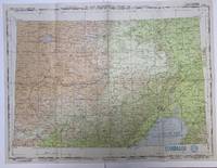
Detroit: U.S. Army Map Service 1945 Book. Very Good. No Binding. 1st Edition. 1945 Good Condition Army Air Forces U.S.A. Aeronautical Chart Dimensions: 74 x 56 cm 29 x 22 inches - Reverse Blanco Detailed Navigational Chart showing the Gulf of Liaotung in Japanese occupied Manchuria Present day China. The map was printed in June 1945 and is marked RESTRICTED. The Chart is prepared for use at night under white ultra-violet red and amber light. This chart was printed just a few months before the Soviet invasion of Manchuria on the 9th of August 1945. . U.S. Army Map Service unknown

 Receive by email
 Download as PDF document
 RSS feed
 Permanent link