|
Surveying Love John
Geossia: or The Art of Surveying and Measuring of Land Made Easy .
London: Printed for A Bettesworth and C. Hitch . and W. Innys 1731. The Fourth Edition. Diagrams. xx 196 16 4 36 8 pp. 1 vols. 8vo. Contemporary calf red leather spine label. Boards missing else clean. The Fourth Edition. Diagrams. xx 196 16 4 36 8 pp. 1 vols. 8vo. Printed for A Bettesworth and C. Hitch ... and W. Innys unknown books
Bookseller reference : 223283
|
|
|
TRADE CATALOGUE: Drafting & Surveying Supplies
Catalog of Eugene Dietzgen Co. Twelfth Edition
Chicago: Dietzgen 1928. hardcover. very good. Color frontispiece of Chicago factory; text illustrations. 489pp. 8vo green cloth spine ends a bit worn. Chicago: Dietzgen. 1928.<br/><br/> Booklet with prices insert in envelope inside back cover; samples of drawing & tracing papers affixed to inside front cover.<br/><br/> Dietzgen unknown books
Bookseller reference : 285641
|
|
|
TRADE CATALOGUE: Drafting & Surveying Supplies
Catalog of Eugene Dietzgen Co. Fourteenth Edition
Chicago: Dietzgen 1931. hardcover. very good-. Color frontispiece of Chicago factory; text illustrations. 520pp. 8vo green cloth rear cover lightly spotted. Chicago: Dietzgen. 1928.<br/><br/> Samples of drawing & tracing papers affixed to inside front cover; price list in back envelope is missing.<br/><br/> Dietzgen unknown books
Bookseller reference : 285642
|
|
|
TRIGONOMETRY and SURVEYING.
18TH C SURVEYING MANUSCRIPT WITH HAND-COLORED ILLUSTRATIONS <br> Géométrique pratique.
<p>Manuscript 4to. 23.5 x 17.5 cm 2 ff. pencil sketch of arms Marlborough and blank 196 ff. and with 27 drawn folding plates many of which are colored. Bound in contemporary French calf spine gilt in six decorative compartments with title on letterpiece. Excellent with all plates drawn and many some colored in a very professional hand.<br /><br /></p><p>Very attractive early 18th-century French illustrated manuscript of practical geometry in seven books including individual sections on longimetry planimetry and stereometry—the fundamentals of precision surveying and draftsmanship. The manuscript closely follows but is not identical to Jacques Ozanam's <i>Géométrie Pratique du sr Boulenger</i> Paris 1684 which itself was a revision of <i>La Géométrie pratique </i>Paris 1640 by the mathematician Jean Boulenger. Though the work was reprinted well into the 18th C the present volume seems to follow Ozanam's 1693 edition most closely. Ozanam's book however lacks the drawn and colored figures of the present volume many of which are quite elaborate. The facade of Notre Dame is shown in an exercise for calculating the height of a wall and a segment on proportion features detailed miniature maps of the Brittany coastline identifying towns such as St. Malo and Mont St. Michel. <br /></p><p>The manuscript exemplifies the early 18th C approach to applied trigonometry—a field that by the mid-17th C was starting to resemble an exact science. Book II defines the common functions sine cosine secant etc.; Book V treats longimetric puzzles such as determining the height of a mountain or a spire or measuring the length of bodies of water; the final two books treat planimetry and stereometry including applied trigonometry—calculating the volumes of real bodies i.e. barrels pipes etc. Those sections of the manuscript that do not appear in <i>Géométrie Pratique</i>—mainly a tract on logarithms and a discussion of surveying instruments—also fall within Ozanam's oeuvre as he published a monograph on compasses in 1673 and a book of logarithmic tables and trigonometric functions in 1685.</p><p>Jacques Ozanam 1640-1717 was best known for his <i>Récréations mathematiques</i> Paris 1694 which "may be regarded as the forerunner of modern books on mathematical recreations." In addition to Boulenger's work he also revised that of Adriaan Vlacq 1600-1667 and the Jesuit mathematician Claude-François Milliet Dechalles.</p> DSB.10 pp.263-265. [France, early 18th century]. books
Bookseller reference : 2805

|
|
|
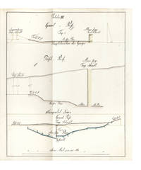
CLAUSTHAL: MINE SURVEYING
Manuscript on paper on mine surveying with 12 large & fine folding manuscript plates heightened in grey blue pink & yellow wash
40 leaves the final blank. Small folio 332 x 210 mm. orig. paste-paper boards spine & extremities somewhat worn uncut. Clausthal: ca. 1815. A fine and legible manuscript instructional manual on techniques and problems of mine surveying. The text is divided into five chapters: "Von der Vorbereitung zum Markscheiden" "On preparations for measuring the area in which mining may be carried out" "Von Bennenung der Gänge und Klüfte" "On the naming of seams and fissures" "Vom Observiren" "On Observations" "Vom Vermaß oder Verbestimmung eines Grubenfelds" "On measuring and defining a mining claim" and "Von Wasserfällen Wasserleitungen und Tiefbau" "On waterfalls water conduits and underground mining". This manuscript was probably prepared in 1815 - plate X has the entry "Markscheide 1.7.15" - at the newly founded mining school at Clausthal the famous mining town of the Harz Mountains in Lower Saxony the fine plates name mining locations in the area. The most attractive plates - all of which contain a number of figures - depict mine shafts mine surveying methods cartographical considerations techniques of prospecting and identification of mineral deposits problems of ownership rights and the constant problems of flooding. All the plates are finely drawn in black ink and have been heightened in grey blue pink and yellow wash. Internally fine. Stamp of Georg Riemschneider 1888-1946 "Oberbergrat" of Clausthal-Zellerfeld. hardcover books
Bookseller reference : 6396
|
|
|
MEYDENBAUER, Albrecht
Handbuch der Messbildkunst in Anwendung auf Baudenkmäler- und Reise-Aufnahmen.
Halle, Knapp 1912. gr.-8°. VIII, 245 S., 108 Abbildungen u. graph. Darst. im Text. HLn. d. Zt., ausgeschiedenes Bibl.-Expl. mit den entsprechenden Kennzeichnungen, Titelbl. etwas stockfl., ansonsten gut erhalten. Albrecht Meydenbauer (1834-1921), deutscher Bauingenieur und neben Aimé Laussedat der Begründer der Photogrammetrie, insbesondere der Architektur-Photogrammetrie. M. erreichte 1885 die Gründung der Messbild-Anstalt für Denkmal-Aufnahmen, die Staatliche Bildstelle Berlin. Diese war die erste photogrammetrisch arbeitende Dienststelle der Welt. M. schuf damit ein Denkmäler-Archiv, das noch heute als das größte fotogrammetrische Kulturgüterarchiv angesprochen wird.
Bookseller reference : PHOT0871
|
|
|
Bartoli, Cosimo
Del modo di misurare le distantie, le superficie, i corpi, le piante, le prouincie, le prospettiue, e tutte le altre cose terrene, che possono no occorrere, a gli huomini, secondo le vere regole d'Euclide, e de gli altri piu lodati scrittori.
Venedig, Per Francesco Franceschi, 1589. Kl.-4°. 143 (von 145) Bl., (3) Bl. Mit 2 gef. Tafeln and more than 145 Holzschnitte im Text. Pappband der Zeit, mit Kleisterpapierbezug. + Wichtig: Für unsere Kunden in der EU erfolgt der Versand alle 14 Tage verzollt ab Deutschland / Postbank-Konto in Deutschland vorhanden +
Bookseller reference : 7573CB
|
|
|
Verzeichniss der Höhen-Fixpunkte im Gebiete der Stadt Zürich. Herausgegeben vom Vermessungsamt der Stadt Zürich
Zürich, Museumsgesellschaft Zürich, 1895. 8°. 166 S., mit vielen ganzseitigen Abbildungen. Halbleinenband mit handschriftlichem Bibliotheks-Rückenschild. + Wichtig: Für unsere Kunden in der EU erfolgt der Versand alle 14 Tage verzollt ab Deutschland / Postbank-Konto in Deutschland vorhanden +, 4834DB|4834DB_2 [2 Warenabbildungen]
Bookseller reference : 4834DB

|
|
|
Davis, Raymond E
Manual of Surveying for Field and Office. In engl. Sprache. Second Edition.
New York: McGraw-Hill Book Comp. 1928. Mit 18 Taf. u. 54 Fig. i. Text. XVI, 1 Bl., 401 S. OLeinen m. Rückenvergold. 18x11 cm.
Bookseller reference : 32330

|
|
|
Via Appia - SECCHI, P. A. (Angelo)
Misura della base trigonometrica eseguita sulla Via Appia per ordine del Governo Pontificio nel 1854 - 55. Dal P. A. Secchi D. C. D,. G.
Roma. Tipografia della Rev. Camera Apostolica 1858. (6), 197, (1) pages and 6 (3 folded) plates in steel engraving. Harc cover binding with spine lettering. (A little rubbes. Paper partially spotted. Title with library stamp). 30x22 cm
Bookseller reference : 135295

|
|
|
Davis, Raymond E., Francis S. Foote and W.H. Rayner
Surveying. Theory and Practice. In engl. Sprache. First Edition. Fourth Impression.
New York: McGraw-Hill Book Comp. 1928. Mit zahlr. Abb. XXIX, 1016 S. Roter OLEinenbd. m. Goldpräg. 20x13 cm.
Bookseller reference : 23564
|
|
|
Barrême, N(icolas)
L'arithmétique. Ou le livre facile pour apprendre l'arithmétique de soi-même, & sans maître.
Paris, Gandouin e.a., 1788. Kl.-8°. xvi, 491, [81] p. avec title et frontisp. in gravure sur bois et quelques figures geometrique dans la texte. Ldr. d. Zt. mit goldgepr. Rückenschild u. reicher floraler Rückenverg. Nouvelle édition, augmentée de plus 190 pages...
Bookseller reference : 95621BB
|
|
|
China Land Surveying and Planning Institute
The Blue Book on China’s Ecological Red Lines 2023
Springer Nature 2025. Hardcover. New. 136 pages. 9.25x6.10x8.80 inches. Springer Nature hardcover
Bookseller reference : x-9819500508 ISBN : 9819500508 9789819500505

|
|
|
National Council of Examiners for Engineering and Surveying
FE Reference Handbook
National Council of Examiners for Engineering and Surveying 2013-09-29. perfect. Good. 10x8x0. National Council of Examiners for Engineering and Surveying unknown
Bookseller reference : 1932613676-3-30473006 ISBN : 1932613676 9781932613674
|
|
|
The Department of Geodesy and Surveying
Exercises In Surveying
Hardcover. Very Good. VG. P/o name. MIchigan book. hardcover
Bookseller reference : FU-0KHC-M5LU
|
|
|
National Council of Examiners for Engineering and Surveying
F E Reference Handbook
National Council of Examiners for Engineering and Surveying 2013. Paperback. New. 9.1 edition. 292 pages. 11.00x8.20x0.80 inches. National Council of Examiners for Engineering and Surveying paperback
Bookseller reference : 1-1932613676 ISBN : 1932613676 9781932613674
|
|
|
[Unidentified German Army "Motorized Surveying and Map Detachment" / Vermessungs- und Karten-Abteilung Motorisiert]
UKRAINE - Two Unrecorded Nazi Wehrmacht Field Printings of Kyiv. "Blick v.d. Lissa Gora auf die Stadt Kijew" Together with: "Blick v.d. Zitadelle Lawra nach Osten und Nordosten
Kyiv 1941. Very good. Together 2 views 205 x 325 mm; 8" x 13" printed on cheap thin paper Ad 1: long closed tear through image without loss light staining creasing edges a little frayed; Ad 2: short closed tears along edges two small holes in blank area at lower left light staining. Overall in very condition suitable for exhibition and study. Tragically topical apparently unrecorded views of Kyiv being rude field printings on cheap paper likely created by Nazis during the so-called "First Battle" of Kiev Aug. 23 - Sept. 26 1941 or shortly thereafter. We are mindful that the present views are historically "toxic" but given the context of the current Russian war-crimes against the people of the Ukraine we believe that there is an urgent need for them to be preserved. <br /> <br /> The first print is a view of Kyiv looking at the city center from the south specifically from the wooded hill of Lysa Hora which had a complex fortification system. During the German occupation the fort became a military plant and tank base. Here Kyiv rises above the Dnipro river on the right. The key below identifies 22 sites mostly of military significance such as buildings bridges power plants hospitals factories churches and cloisters. To each site is assigned a code consisting of a letter or letters and a numeral or numerals: these are certainly map references i.e. K10 L10 F-G7 etc. We have been unable to locate this exact map but large bird's-eye maps of Kyiv taken by the Vermessungs- und Karten-Abteilung survive in the Kiev Polytechnic Museum and also the David Rumsey Collection. That a need for vantage-point views such as ours to accompany such a map seems self-evident. <br /> <br /> The second is a view of Kyiv taken from the Great Lavra Bell Tower in the Pechersk Lavra monastery strategically positioned in the city center looking towards the Dnieper Valley in the northeast. The key identifies 13 sites likewise militarily important but with the notable inclusion of the "Podol Judenstadt" no. 6 a Jewish neighborhood to the north of the city. <br /> <br /> Our prints may date before Nov. 3 1941 because on this day just two months into the German occupation of Kyiv a huge explosion brought down the Uspensky Sobor cathedral in the Pechersk Lavra monastery across the courtyard from the Bell Tower from which the present view was drawn.<br /> <br /> The "Motorized Surveying and Map Detachment" was an integral part of the German military and accompanied the army throughout the European and North African theater. These surveyors photographers and printers traveled with equipment to the front lines sometimes on special trains. The detachments were self-contained and had the capability to print onsite even in the most hostile conditions. Ephemeral views such as the present pair were printed in small numbers for the sole use of German occupying troops. The present prints were purchased by a Munich bookseller from a private collector in Germany along with other documents from the period.<br /> <br /> NOTA BENE: These prints were both purchased at an auction in Germany in early January 2021 i.e. BEFORE the Russian invasion of Ukraine on February 24 2022. unknown
Bookseller reference : 3877

|
|
|
American Congress on Surveying and Mapping
Definitions of Surveying and Associated Terms
paperback. Good. Access codes and supplements are not guaranteed with used items. May be an ex-library book. paperback
Bookseller reference : 0976599104.G ISBN : 0976599104 9780976599104
|
|
|
National Council of Examiners for Engineering and Surveying Staff
FE Reference Handbook
National Council of Examiners for Engineering & Surveying 2013. Perfect Paperback. Good. Disclaimer:A copy that has been read but remains in clean condition. All pages are intact and the cover is intact. The spine may show signs of wear. Pages can include limited notes and highlighting and the copy can include previous owner inscriptions. An ex-library book and may have standard library stamps and/or stickers. At ThriftBooks our motto is: Read More Spend Less.Dust jacket quality is not guaranteed. National Council of Examiners for Engineering & Surveying paperback
Bookseller reference : G1932613676I3N10 ISBN : 1932613676 9781932613674

|
|
|
National Council of Examiners for Engineering and Surveying Staff
FE Reference Handbook
National Council of Examiners for Engineering & Surveying 2013. Perfect Paperback. Acceptable. Readable copy. Pages may have considerable notes/highlighting. ~ ThriftBooks: Read More Spend Less.Dust jacket quality is not guaranteed. National Council of Examiners for Engineering & Surveying paperback
Bookseller reference : G1932613676I5N00 ISBN : 1932613676 9781932613674

|
|
|
National Council of Examiners for Engineering and Surveying
PE Civil Engineering: Water Resources and Environmental Practice Exam
National Council of Examiners for Engineering and Surveying 2014. Paperback. New. 96 pages. 11.20x9.00x0.50 inches. National Council of Examiners for Engineering and Surveying paperback
Bookseller reference : 1-1932613749 ISBN : 1932613749 9781932613742
|
|
|
American Congress on Surveying and Mapping
Definitions of Surveying and Associated Terms
ACSM 0000-00-00. Revised Edition. paperback. Used: Good. 0.00x0.00x0.00. Buy with confidence. Excellent Customer Service & Return policy. ACSM paperback
Bookseller reference : SONG0976599104 ISBN : 0976599104 9780976599104
|
|
|
American Congress on Surveying and Mapping
Definitions of Surveying and Associated Terms
ACSM 2005. Paperback. Good. Disclaimer:A copy that has been read but remains in clean condition. All pages are intact and the cover is intact. The spine may show signs of wear. Pages can include limited notes and highlighting and the copy can include previous owner inscriptions. At ThriftBooks our motto is: Read More Spend Less.Dust jacket quality is not guaranteed. ACSM paperback
Bookseller reference : G0976599104I3N00 ISBN : 0976599104 9780976599104
|
|
|
National Council of Examiners for Engineering and Surveying Staff
FE Reference Handbook
National Council of Examiners for Engineering & Surveying 2013. Perfect Paperback. Good. Pages can have notes/highlighting. Spine may show signs of wear. ~ ThriftBooks: Read More Spend Less.Dust jacket quality is not guaranteed. National Council of Examiners for Engineering & Surveying paperback
Bookseller reference : G1932613676I3N00 ISBN : 1932613676 9781932613674
|
|
|
National Council of Examiners for Engineering and Surveying Staff
Fundamentals of Engineering Supplied-Reference Handbook
National Council of Examiners for Engineering & Surveying 2008. Perfect Paperback. Very Good. Disclaimer:A copy that has been read but remains in excellent condition. Pages are intact and are not marred by notes or highlighting but may contain a neat previous owner name. The spine remains undamaged. At ThriftBooks our motto is: Read More Spend Less.Dust jacket quality is not guaranteed. National Council of Examiners for Engineering & Surveying paperback
Bookseller reference : G1932613374I4N00 ISBN : 1932613374 9781932613377
|
|
|
SURVEYING MANUSCRIPT IN FRENCH -
Levées des Villages à la Planchette Survey of villages on a map-board.
France Paris Undated around 1770. Folio. 425 x 28 cm. Loose sewn 4 by 4 leaves in portfolio with ties. Title-page and 9 pp. written in a fine large legible hand but unidentified in brown ink. Having 5 No 1-5 manuscript maps and plans in double folio with some hand-colouring. On good thick paper clean and fine. unknown
Bookseller reference : 59178
|
|
|
FLINDERS, MATTHEW. - SURVEYING THE COAST OF NEW HOLLAND.
Concerning the Differences in the Magnetic Needle on Board the Investigator arising from an Alteration in the Direction of the Ship's Head. Read March 28 1805.
London W. Bulmer and Co. 1805. 4to. No wrappers as extracted from "Philosophical Transactions" 1805. With titlepage to Phil. Transactions Part I. Pp. 186-197. Having also the titlepage to the volume Part II 1805. A few scattered brownspots and very faint browning to outer margins otherwise fine and wide-margined. A small stamp to verso of titlepage. <br/><br/><em>First printing of probably the first work to discover and correct for the errors of the compass caused by the iron in ships by the first circumnavigator of Australia."Captain Matthew Flinders RN 16 March 1774 - 19 July 1814 was one of the most successful navigators and cartographers of his age. In a career that spanned just over twenty years he sailed with Captain William Bligh circumnavigated Australia and encouraged the use of that name for the continent which had previously been known as New Holland. He survived shipwreck and disaster only to be imprisoned for violating the terms of his scientific passport by changing ships and carrying prohibited papers. He identified and corrected the effect upon compass readings of iron components and equipment on board wooden ships and he wrote what may be the first work on early Australian exploration A Voyage to Terra Australis."Wikepedia </em> unknown
Bookseller reference : 45129
|
|
|
(Surveying) Love, John
Geossia: or The Art of Surveying and Measuring of Land Made Easy …
London: Printed for A Bettesworth and C. Hitch … and W. Innys 1731. The Fourth Edition. Diagrams. xx 196 16 4 36 8 pp. 1 vols. 8vo. Contemporary calf red leather spine label. Boards missing else clean. Signed Wm. G. Barrows. Brunswick Maine Dec. 16 1882. The Fourth Edition. Diagrams. xx 196 16 4 36 8 pp. 1 vols. 8vo. Printed for A Bettesworth and C. Hitch … and W. Innys unknown
Bookseller reference : 223283
|
|
|
TRADE CATALOGUE): Drafting & Surveying Supplies
Catalog of Eugene Dietzgen Co. Twelfth Edition
Chicago: Dietzgen 1928. hardcover. very good. Color frontispiece of Chicago factory; text illustrations. 489pp. 8vo green cloth spine ends a bit worn. Chicago: Dietzgen. 1928.<br/> <br/> Booklet with prices insert in envelope inside back cover; samples of drawing & tracing papers affixed to inside front cover.<br/> <br/> Dietzgen unknown
Bookseller reference : 285641
|
|
|
TRADE CATALOGUE): Drafting & Surveying Supplies
Catalog of Eugene Dietzgen Co. Fourteenth Edition
Chicago: Dietzgen 1931. hardcover. very good-. Color frontispiece of Chicago factory; text illustrations. 520pp. 8vo green cloth rear cover lightly spotted. Chicago: Dietzgen. 1928.<br/> <br/> Samples of drawing & tracing papers affixed to inside front cover; price list in back envelope is missing.<br/> <br/> Dietzgen unknown
Bookseller reference : 285642
|
|
|
National Council of Examiners for Engineering and Surveying
FE Reference Handbook
Used - Very Good. Used book that is in excellent condition. May show signs of wear or have minor defects. unknown
Bookseller reference : 12746416-6 ISBN : 1932613676 9781932613674
|
|
|
[SURVEYING]. FLINT, Abel & GILLET, George.
A system of geometry and trigonometry: with a treatise on surveying in which the principles of rectangular surveying without plotting are explained. . . .
Hartford CT: Belknap and Hamersley 1844. 8vo. 160; 112 pp. Numerous woodcut engraved diagrams figures. Contemporary full speckled calf speckled fore-edges tan & gilt morocco spine label minor shelfwear slight rubbing occasional light foxing still an excellent copy. Third edition revised & expanded of this popular American treatise on surveying published originally in 1804 would continue to be updated and revised for over half a century. An edition of Abel Flint’s work was one of the two consulted by Abraham Lincoln while he studied to become a surveyor as it emphasized higher math including logarithms plane geometry and trigonometry. Belknap and Hamersley, unknown
Bookseller reference : 55840
|
|
|
[SURVEYING -- SCIENTIFIC INSTRUMENTS]. BACHMANN, F.
Die Theorie und Praxis des Nivellirens mit besonderer Rucksicht auf Libelleninstrumente. . . .
Weimar: Bernhard Friedrich Voigt 1838. 8vo. 239 1 pp. Numerous tables. Six large folding engraved plates some hand-coloured w/ instruments and cartographic details. Contemporary quarter-tree-calf over chppng ft of spine mnr splttng to hnges foxing to textblk mnr creasng to Plate VI still good reference copy. First edition of this exceedingly scarce work on surveying detailing the equipment and leveling instruments w/ details on cartography. Bernhard Friedrich Voigt, unknown
Bookseller reference : 38922
|
|
|
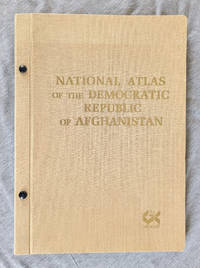
Organization for Surveying & Cartography GEOKART
National Atlas of the Democratic Republic of Afghanistan
<p>Organization for Surveying & Cartography GEOKART 1985. Hardcover. Very Good/no jacket. Brown cloth gilt title 14-in tall bibliography. Bound with publisher's 2 screw posts. 63 maps on 36 pp illustrating almost all important aspects within Afghanistan's physical and socio-economic geography: climate geology agriculture industry education street and road maps etc. Clean and unworn covers show mild bow fading at top edge. Pastedown with brown tone from publisher's glue.</p> Organization for Surveying & Cartography GEOKART hardcover
Bookseller reference : 005135 ISBN : 8300023275 9788300023271
|
|
|
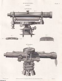
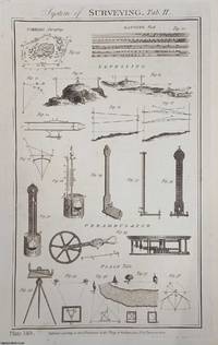
SURVEYING
1818. Surveying Equipment. 11 original plates: Levels; Dendrometers; Coggeshall's Sliding Rule; Grand Theodolite by Ramsden; etc. From Abraham Rees' Cyclopaedia or Universal Dictionary of Arts Sciences and Literature
Longman Hurst Rees Orme & Brown London 1818. Unframed Print. Very Good Condition. 11 original plates with NO ACCOMPANYING TEXT. Plate 9 the Portable Theodolite by Troughton is quite browned the others are clean and bright. Rees's Cyclopaedia in full The Cyclopaedia; or Universal Dictionary of Arts Sciences and Literature was an important 19th-century British encyclopaedia edited by Rev. Abraham Rees 1743£££1825 a Presbyterian minister and scholar who had edited previous editions of Chambers's Cyclopaedia. Philosophical radicalism was suspect in Britain and aspects of the Cyclopaedia were thought to be distinctly subversive and attracted the hostility of the Loyalist press. These reviews complained about its supposed antireligious aspects and radical standpoints attributed to its editor and contributors and cited lack of article balance. The Quarterly Review commented "Rees is the most extensive cyclopaedia in English with many excellent articles it has generally been condemned as on the whole too diffuse and too commonplace." Wikipedia. THERE IS MORE THAN ONE PICTURE OF THIS ITEM TO SHOW YOU MORE DETAILS. Size: 21 x 27 cms. Quantity Available: 1. Category: Rees Cyclopaedia; Unframed Prints : Old; PRINTS : Antiquarian Interest; Special Features. Inventory No: 365574. This item may require more postage than the rates shown for delivery outside the UK. If extra postage is required we will contact you before processing your order and you will be given the details and option to decline the extra cost. Longman, Hurst, Rees, Orme & Brown unknown
Bookseller reference : 365574
|
|
|
SURVEYING
1790. System of Surveying. 3 Plates. Original plates from the New Royal Cyclopaedia and Encyclopaedia 1790
Alex. Hogg Paternoster-Row London 1790. Second Edition. Unframed Print. Very Good Condition. 3 plates. No text. Posted rolled in a tube. Note; this is a group of original plates separated from the volume not a reprint or copy. Size: 26 x 43 cms approx. Quantity Available: 1. Category: Royal Encyclopaedia; Printed before 1800; Inventory No: 364945. Alex. Hogg, , Paternoster-Row unknown
Bookseller reference : 364945
|
|
|
National Council of Examiners for Engineering and Surveying
Fundamentals of Engineering FE: Discipline Specific Reference Handbook
National Council of Examiners for Engineering and January 1996. Oversized Paperback. Very Good - Cash. Third Edition December 1997. Minor rubbing and edge wear to cover with light reader wear to pages. Sun bleached spine. Pages appear unmarked. Still great condition. Stock photos may not look exactly like the book. National Council of Examiners for Engineering and paperback
Bookseller reference : 1020570
|
|
|
National Council of Examiners for Engineering and Surveying
FE Reference Handbook 10.1
Used - Good. Used book that is in clean average condition without any missing pages. unknown
Bookseller reference : 39679642-6 ISBN : 1947801112 9781947801110
|
|
|
National Council of Examiners for Engineering and Surveying
FE Reference Handbook
National Council of Examiners for Engineering and Surveying 2013-09-29. Perfect Paperback. Acceptable. 10x8x0. National Council of Examiners for Engineering and Surveying paperback
Bookseller reference : 1932613676-4-25830323 ISBN : 1932613676 9781932613674
|
|
|
National Council of Examiners for Engineering and Surveying
FE Reference Handbook
National Council of Examiners for Engineering and Surveying 2013-09-29. Perfect Paperback. Good. 10x8x0. National Council of Examiners for Engineering and Surveying paperback
Bookseller reference : 1932613676-3-22494230 ISBN : 1932613676 9781932613674
|
|
|
National Coucil of Examiners for Engineering and Surveying
Fundamentals of Engineering F.E. Sample Examination
NCEES 1993. Paperback. Good. Pages can have notes/highlighting. Spine may show signs of wear. ~ ThriftBooks: Read More Spend Less.Dust jacket quality is not guaranteed. NCEES paperback
Bookseller reference : GB000WEI5YWI3N00
|
|
|
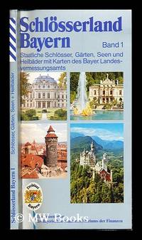
National Surveying Office
schlosserland bayern band 1: staatliche schlosser garten seen und heilbader mit karten des bayer. landesvermessungsamts
Bayern: Eine Information des Bayerischen Statsministeriums der Finanzen 1986. First Edition. Softcover. Fine copy in the original color-printed stiff-card wrappers. Particularly and surprisingly well-preserved; tight bright clean and especially sharp-cornered. Physical description; 120 pages. Notes; No date given. Subjects; Schlosserland bayernband1. State locksmith. garden. lakes. health resorts. maps of the bayer. Bayern: Eine Information des Bayerischen Statsministeriums der Finanzen paperback
Bookseller reference : 235287
|
|
|
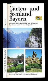
Bavarian Land Surveying Office
Garten- und Seenland Bayern mit Staatlicher Seenschiffahrt und Karten des Bayerischen Landesvermessungsamts
Bayerisches Staatsministerium der Finanzen 1995. First Edition. Softcover. Fine copy in the original color-printed stiff-card wrappers. Particularly and surprisingly well-preserved; tight bright clean and especially sharp-cornered. Physical description; 166 pages. Subjects; Bavaria. Garden and Lake District. State Lake Shipping. Maps. Bavarian Land Surveying Office. Bayerisches Staatsministerium der Finanzen paperback
Bookseller reference : 235232
|
|
|
National Council of Examiners for Engineering and Surveying
FE Reference Handbook
Used - Good. Used book that is in clean average condition without any missing pages. unknown
Bookseller reference : 5344891-6 ISBN : 1932613676 9781932613674
|
|
|
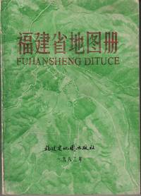
[FUJIAN PROVINCIAL BUREAU OF SURVEYING AND MAPPING] 福建省测绘局.
福建省地图册 Fujian sheng ditu ce. Atlas of the Province of Fujian.
Fujian: 福建省地图出版社. Fujian sheng ditu chubanshe. 1982. Numerous coloured maps paginated to 140pp explanatory text pages unpaginated 18.2 x 13cm text in simplified Chinese characters paperback. Maps very vivid and clear text in printed in blue a prior owner's red chop on front endpaper wrapper and title on spine worn. Good copy. . 福建省地图出版社. Fujian sheng ditu chubanshe. paperback
Bookseller reference : 219723
|
|
|
Great Britain: Property Services Agency: Directorate of Building and Quantity Surveying Services
Schedule of Rates for Maritime Works 1984 Schedule
The Stationery Office Books. Used - Acceptable. Used - Acceptable. Sticker on cover. Ships from UK in 48 hours or less usually same day. Your purchase helps support Sri Lankan Children's Charity 'The Rainbow Centre'. Ex-library with wear and barcode page may have been removed. 100% money back guarantee. We are a world class secondhand bookstore based in Hertfordshire United Kingdom and specialize in high quality textbooks across an enormous variety of subjects. We aim to provide a vast range of textbooks rare and collectible books at a great price. Our donations to The Rainbow Centre have helped provide an education and a safe haven to hundreds of children who live in appalling conditions. We provide a 100% money back guarantee and are dedicated to providing our customers with the highest standards of service in the bookselling industry. The Stationery Office Books unknown
Bookseller reference : Z1-W-023-00989 ISBN : 0116715049 9780116715043
|
|
|
National Council of Examiners for Engineering and Surveying
FE Reference Handbook
unknown
Bookseller reference : BIBUP61025-A52924 ISBN : 1947801112 9781947801110
|
|
|
Canadian Institute of Surveying
Proceedings -- 2nd Seminar on Air Photo Interpretation in the Development of Canada Held at Ottawa March 13-15 1967
Canada: Interdepartmental Committee on Air Surveys & Canadian Institute of Surveying 1968. Paper Back. Very Good -/No Jacket. 4to - over 9¾" - 12" tall. 214pp.; SC brwn.w/white; rubbed w/some weare on edges&corners; hole-punchbttm.cover; cleantight pgs. "The accent of this symposium was on photo-interpretation as it relates to the utilization of land resources and on the education for present and future photo-interpreters." illus. <br/> <br/> Interdepartmental Committee on Air Surveys & Canadian Institute of Surveying unknown
Bookseller reference : 019872
|
|
|
ASCE Committee on Engineering Surveying
Report on Highway and Bridge Surveys
New York: American Society of Civil Engineers 1962. Paper Back. Near Fine/No Jacket. 8vo - over 7¾" - 9¾" tall. 147pp.; SC blue w/blk.; slight rub w/some sun on spine; PONstampcover; cleantight pgs. " .task of the committee.the encouragement of the use of modern techniques and high accuracy standards in surveying and mapping for planning design and construction of highways and bridges." includes errata. ASCE Manuals and Reports on Engineering Practice No.44 <br/> <br/> American Society of Civil Engineers unknown
Bookseller reference : 025315
|
|
|
(CLAUSTHAL: MINE SURVEYING)
Manuscript on paper on mine surveying with 12 large & fine folding manuscript plates heightened in grey blue pink & yellow wash
40 leaves the final blank. Small folio 332 x 210 mm. orig. paste-paper boards spine & extremities somewhat worn uncut. Clausthal: ca. 1815.<br/> <br/> A fine and legible manuscript instructional manual on techniques and problems of mine surveying. The text is divided into five chapters: “Von der Vorbereitung zum Markscheiden†“On preparations for measuring the area in which mining may be carried out†“Von Bennenung der Gänge und Klüfte†“On the naming of seams and fissures†“Vom Observiren†“On Observations†“Vom Vermaß oder Verbestimmung eines Grubenfelds†“On measuring and defining a mining claim†and “Von Wasserfällen Wasserleitungen und Tiefbau†“On waterfalls water conduits and underground miningâ€.<br/> <br/> This manuscript was probably prepared in 1815 — plate X has the entry “Markscheide 1.7.15“ — at the newly founded mining school at Clausthal the famous mining town of the Harz Mountains in Lower Saxony the fine plates name mining locations in the area.<br/> <br/> The most attractive plates — all of which contain a number of figures — depict mine shafts mine surveying methods cartographical considerations techniques of prospecting and identification of mineral deposits problems of ownership rights and the constant problems of flooding. All the plates are finely drawn in black ink and have been heightened in grey blue pink and yellow wash.<br/> <br/> Internally fine. Stamp of Georg Riemschneider 1888-1946 “Oberbergrat†of Clausthal-Zellerfeld. unknown
Bookseller reference : 6396
|
|
 Receive by email
 Download as PDF document
 RSS feed