|
CHINA BEIJING
Guide to Peiping and its Environs.
Peiping.: The Peking Bookshop Printed by Catholic University Press. 1946. Booklet in pictorial paper covers 7 x 5 inches 144 pp. single color photo-illustrations three folded maps one single page map plus advertising pages at front and rear. Previous owner's signature in small ink letters on front cover; light wear to front cover; booklet in good clean condition overall. Booklet is in three parts: Part I features General Information A Short History Notes on Aspects of the Culture and an English-Chinese Vocabulary. This portion according to instructions is to be read before the tourist visits in order to acquire general background information. Part II features tours of the city with more than a dozen itineraries profiled. Part III focuses on the Environs of Peiping. . The Peking Bookshop (Printed by Catholic University Press) unknown
Referentie van de boekhandelaar : 54545

|
|
|
CHINA HONG KONG & PEIPING INSETS
Cram's Map of China.
Indianapolis.: The George F. Cram Co. Inc. No date. Ca. 1942. Color map 13 1/2 x 20 3/4 inches on sheet size 16 x 22 inches folding as issued into stiff card wrappers 8 1/2 x 4 1/2 inches. Light creasing to edges of wrappers map is on fine condition. Exceptional detail to this uncommon independent map issue from the Cram company. A wealth of towns are marked on this map issued just after the United States entered the second world war. There is a small inset of Peiping and Environs and one of HongKong and Territorial Concessions. The "Explanation" at lower right lists English translations for Chinese words such as fu ting chau and hsien cities of the 1st to 4th ranks ling mountain chain mo desert etc. . The George F. Cram Co., Inc. unknown
Referentie van de boekhandelaar : 54514

|
|
|
CHINA SECOND SINO JAPANESE WAR SHANGHAI NANJING
Photo Album of Famous Places in Central Southern China 中南支名所写真帖
1938. Black and white photo illustrations numbered 1 to 124 3 1/4 x 5 3/4 inches textured cloth over card binding with gold title and silver decorative image. Text block has separated from binding. Sections are bound with thread which has come loose on some of the sections. Light dampstaining to inner area of sheets throughout but not very noticeable on most sheets. This small booklet of 124 numbered photos would seem to celebrate the successful Japanese incursions into China and the 1937 capture of the cities of Shanghai and Nanjing of which there are many photos. The majority of the photos are of these two cities with additional ones of rivers and countryside projecting a sense of normalcy in southern China. No record for this title has been found in WorldCat under the translation "Photo Album of Famous Places in Central Southern China." A brief selection of the 124 titles includes: 1 Shanghai Peace Memorial 2 Shanghai Bund 3 Shanghai Garden Bridge 4 Shanghai Japan Naval Corps 海軍陸戦隊 15 Shanghai Park Hotel 16 Shanghai French Park 17 Shanghai China Post Bureau 18 Shanghai French Settlement 55 Nanjing National Government 南京 元国民政府 possibly Former National Government. 56 Nanjing Zhongshan Road - the main street of central Nanjing 南京 中山路 南京域内のメインストリート 66 Snapshot of Yangtze River 109 Southern Chinese style sanpan . hardcover
Referentie van de boekhandelaar : 52148

|
|
|
CHINA PEKIN / BEIJING
Tourist Map of Peking.
Peking.: Peking Publishing House. 9- 1959. Broadside 30 x 21 inches folding to 7 x 5 inches total of ten color maps. A most interesting collection of maps of Peking dating to tenth anniversary of the founding of the People's Republic of China and the year following the launch of the economic and social policies of the Great Leap Forward. On one side is a nine panel map "Sketch Map of Peking Streets" plus three smaller transportation maps 'Communications in Peking's Outskirts' plus City Bus Lines and Tram and Trolley Bus Routes; on the other side are maps of: the Imperial Palace Museum Chungshan Park & Working People's Cultural Palace'; Peihai Park; Yi Ho Yuan the Summer Palace; Tien Tan 9the Temple of Heaven; Hsiangshan; and the Peking Zoo. . Peking Publishing House. unknown
Referentie van de boekhandelaar : 54602

|
|
|
CHINA PEIPING BEIJING Wang Wenzhi.
A Bird's-Eye View of Peiping and Environs. 北平城郊鸟瞰图
Peiping.: The Peiping Chronicle. 10-1- 1936. Color pictorial map 28 3/4 x 41 3/4 inches on sheet size 36 x 44 inches. Short splits at two fold ends left hand side and one longer split at right fold end just to neat line; separations at three fold intersections one approx. 1 1/2 inches long with tiny paper loss. Light creasing to a couple of areas but image is clean and bright and in very good condition. An extraordinary richly colored bird's eye view style map of the Chinese capital Beijing. WorldCat records the illustrator as by Wen-Chih Wang from the envelope which this copy lacks 218 places of interest are noted in English and Chinese text beneath the map. . The Peiping Chronicle. unknown
Referentie van de boekhandelaar : 43786

|
|
|
CHINA DECORATIVE ART
Ornements de la Chine. Plate 32-33. Birds on flowering bamboo branches.
Paris.: Canson Libraire-Editeur. 1883. Chromolithograph image area approximately 26 1/2 x 18 1/2 inches on sheet 35 1/2 x 25 inches centrefold as issued. Very good condition: some light soiling to outer margins outside image area 3/4 inch tear and chip to mid left edge not affecting image 1/2 tear to lower right edge image very bright and clean. Toned appearance to background along centerfold is from photography only and is not on actual print. Richly colored and attractive plate with flowers and birds. This is a double plate 32-33 from the portfolio Ornements de la Chine: Recueil de Dessins Pour l'Art et l'Industrie par E. Collinot et A. De Beaumont of which only 500 copies were issued. . Canson, Libraire-Editeur. unknown
Referentie van de boekhandelaar : 41500

|
|
|
CHINA BEIJING Sewall John Kirk illus.
A Pictorial Map of Peiping in full colours. Map title: Peiping.
Tientsin / Peiping.: Peiyang Press Ltd. No date. Ca. 1928- 1933. Color pictographic / pictorial map 22 3/4 x 19 inches on sheet size 23 1/2 x 19 1/2 60 x 49.5 cm folding as issued into titled paper pocket 8 x 4 1/4 inches. A particularly bright clean copy in original protective pocket. A few tiny spots of ink from the printing process no tears. A scarce and handsome pictorial map of the inner city of Peiping Peking/Beijing by John Kirk Sewall showing Tartar City Chinese City and the Forbidden City with people and animals in silhouette and temples theaters etc in bright colors. The WorldCat entry for this map with holdings at three libraries notes "The map is decorated with small illustrations of landmark buildings and black silhouettes of workers pedestrians and animals. Essentially a tourist map since it includes sightseeing attractions rail station hotels etc. It also depicts the Legation Quarter.Imprint date based on the first use of Peiping in 1928 and the representation of the German Legation by the black red and gold Reichsbanner flag which was banned in 1933." The Wikipedia entry notes that the horizontal black white and gold flag was "In use at the beginning of the Weimar Republic 1918–1919 by the foreign services 1922–33 and by the Nazi regime from March 1933 until August 1935." . Peiyang Press, Ltd. unknown
Referentie van de boekhandelaar : 41893

|
|
|
CHINA / RUSSIA / JAPAN Burke Howard illus.
Japan and Russia Will Divide China. Signs Increase That Northern Area and Lower Yangtze Basin Will be Carved Into Puppet States by Stalin and Mikado Leaving South Largely at Mercy of Both. PICTORIAL REVIEW: Los Angeles Examiner Sunday April 28 1940.
Los Angeles.: Los Angeles Examiner. 1940. Color pictorial map FRONT PAGE ONLY of the Los Angeles Examiner March of Events section archivally mounted on linen newspaper sheet 21 1/2 x 16 3/4 inches. Slight discoloration to lower centrefold overall very good condition. A dynamic map / illustration by Los Angeles Examiner artist Howard Burke covering the area China Japan Southern Russia and the northern part of French IndoChina and Siam showing how the "Aggressors Divide China." Areas under Japanese occupation are shown in red. Informative text labels including sources of agricultural and raw materials and small pictographs provide an effective overview of the geopolitical situation in keeping with the "air-age" geographical imagination of the mid 20th century whose prominent practitioners included Richard Edes Harrison and Los Angeles Times artist Charles Owens. . Los Angeles Examiner. unknown
Referentie van de boekhandelaar : 54359

|
|
|
CHINA COOKERY / DOGS WORLD WAR II ERA
Chinese Recipes TOGETHER WITH Chinese Dogs. TWO BOOKLETS.
Los Angeles.: Quon-Quon Company. 1942-1944. Two 16 pp. miniature booklets 4 3/4 x 4 inches from a series published by Quon-Quon Company of Los Angeles in the 1940s. "Chinese Recipes" second edition copyright 1942; "Chinese Dogs" illustrated copyright 1944. Slight indentation to front cover of Recipes booklet otherwise very good condition. The Recipe booklet is stuffed with brief paragraph long instructions for making a full range of Chinese food including 'Kettle-Cooked Duck.' The introduction states: "this second edition of Chinese Recipes is made necessary by public demand and by other vital considerations. For example several recipes given in the first edition and which call for ingredients not obtainabale during the present world-crisis have been eliminated." The Dogs booklet is illustrated with black and white sketches and has a section "Show-points of Chinese Dogs and Distinguishing Characteristics." A jaw-dropping gift for someone expecting more. . Quon-Quon Company. unknown
Referentie van de boekhandelaar : 54321

|
|
|
CHINA MA JONG Wang Shun Tai.
Directions for Playing "Ma Jong"
Shanghai.: Wang Shun Tai. No date. Ca. 1950s. Pamphlet in English 9 pp. 7 3/4 x 5 1/2 inches paper wraps decorative color cover. Good clean condition. An engaging item for the collector providing instruction for playing Mah Jong. Cover states "Wang Shun Tai Hsuanchi Road Made in China Shanghai." First page illustrates the playing pieces and formations. An uncommon ephemeral item; instructions in English are at times difficult to follow. Further information on front cover in Chinese. . Wang Shun Tai. paperback
Referentie van de boekhandelaar : 54320

|
|
|
China Sports Editorial Board
Simplified Taijiquan also known as T'ai chi ch'uan. China Sports Series 1
Beijing: China Sports Editorial Board 1980. First edition. Paperback. Good . China Sports Editorial Board paperback
Referentie van de boekhandelaar : 500045894
|
|
|
CHINA Southard Frank Randolph mapmaker.
Picture Map of China. 中國地圖
New York.: Friendship Press. 1932. Wall-sized pictorial map 37 1/4 x 48 1/2 inches on sheet 38 1/4 x 49 3/4 inches 97.5 x 126 cm originally folded now archivally mounted on linen. Evidence of some minor chipping to folds now minimsed. Color pencil additions to the map outlining two regions. A good example of the scarce 1932 pictorial map of China by Frank Randolph Southard published by Friendship Press the publishing arm of the National Council of Churches in New York. The map was designed as a teaching tool in classrooms and in this vein the added color on the copy offered here delineates a section of northeast China and a large swath of western China. The map is on a scale of 1:16000000. The outside border of the map shows various Chinese symbols such as the yinyang the wheel of law the pearl long life etc. The inner border shows scenes of life in China: at home at work at school in the street. The map itself is quite schematic showing elevation pictorially rivers major cities. Listed in WorldCat at only three libraries the scarcity of this map is no doubt due to its size and its practical application. A handsome map with much interesting commentary on the Western view of China in the years before World War II. . Friendship Press. unknown
Referentie van de boekhandelaar : 53564

|
|
|
CHINA GREAT LEAP FORWARD
Life Magazine.
Chicago.: Time. 01-05- 1959. January 5 1959 issue of the magazine color and b/w ills folio 14 x 10.5 inches color pictorial wrappers as issued. Address label at lower left. Good condition. Cover photo: "New Generation Chinese at Anti-U.S. Rally". Coverage on China includes a photographic essay by Henri Cartier-Bresson: "Red China bid for a future: young and old join in the 'Great Leap Forward'" and an article by James Bell "Misery oppression fear inside China's communes." . Time. unknown
Referentie van de boekhandelaar : 29364

|
|
|
CHINA BEIJING SUMMER OLYMPICS
One World One Dream - Beijing Olympic Venues.
Beijing.: Press Commission of the Chinese Olympic Committee. 2007. Very large wall calendar for 2007 16 x 21 inches printed on high quality paper featuring twelve color illustrations of venues presumably most under construction for the 2008 Summer Olympics in Beijing. Text on cover page reads "One World One Dream - Beijing Olympic Venues" with similar identification in Chinese. Each building is identified in multiple languages beneath a 10 x 19 inch artist rendering of the site. This high quality calendar is in excellent clean condition. Evidently uncommon: no WorldCat listing. The sites depicted are in order in which they appear and as they are identified on the calendar: National Stadium widely known as the Bird’s Nest National Aquatics Centre Beijing Shooting Range Hall Laoshan Velodrome Wukesong Indoor Stadium. National Indoor Stadium Shunyi Olympic Rowing-Canoeing Park China Agricultural University Gymnasium Peking University Gymnasium Beijing Science and Technology University Beijing University of Technology Gymnasium Quingdao International Sailing Marina at Fushan Bay. Evidently many of these venues were abandoned following the Summer Olympics components salvaged or the sites left to they elements and recent photos provide an eerie footnote to the 2008 summer competitions and their purpose-built venues. . Press Commission of the Chinese Olympic Committee? unknown
Referentie van de boekhandelaar : 53919

|
|
|
CHINA
China A Brief History of the Celestial Empire. The Great Round World Quarterly. No. 2. Double Number. October 1898.
New York.: The Great Round World Publishing Co. 10- 1898. Booklet 8 1/4 x 5 inches color pictorial paper wrappers black and white photo and line illustrations throughout. Fine condition. Published at the time of the Boxer Rebellion the Preface begins: "The Chinese Empire and its future are now subjects which probably receive more thought and comment than any others." The booklet provides a history of China with much detail of the Sino-Japanese war information on the Empress Dowager and other general information on the country. The Great Round World was published as a weekly news journal for the whole family. . The Great Round World Publishing Co. unknown
Referentie van de boekhandelaar : 53972

|
|
|
CHINA PEKING / BEIJING
Carte Touristique de Pekin. Tourist Map of Peking.
Editions cartographiques. 1957. Broadside 30 x 21 inches folding to 7 x 5 inches total of ten color maps. Some ink notations on maps light wear to cover couple of splits at fold ends light stain to lower edge of cover good condition. A most interesting collection of maps of Peking dating to the year preceding the launch of the economic and social policies of the Great Leap Forward. On one side is a nine panel map of the urban region of Peking plus three smaller transportation maps; on the other side are maps of: the Imperial Palace Museum the Sun Yat-sen Park and Palace of Culture; Peihai Park; the Summer Palace; the Temple of Heaven; the Palace of the USSR Exposition; and the Zoo. . Editions cartographiques. unknown
Referentie van de boekhandelaar : 53967

|
|
|
CHINA PEKIN / BEIJING
A Sketch of a Journey from Zhe-Hol in Tartary by land to Pekin and from thence by water to Hang-Tchoo-Foo in China.
London.: George Nicol. No date. 1797. Copperplate engraved map 25 x 17 1/2 63 x 45 cm on sheet 29 1/2 x 221/2 inches centrefold couple of light spots at right centre light discoloration to sheet edges light undulations to sheet overall clean and in very good condition. An exquisitely engraved map with fine detail of the route taken by George Macartney on the first official British embassy to China 1792-1794 undertaken with the aim of gaining trade concessions from the Chinese Emperor. While the official purpose was not successful much was learned about China and the Chinese as is evident from this map with its explanatory texts. To the west of Pekin just below the starting point at Zhe-holJehol which is situated at the top of this map the commentary reads: "A great part of the country around Pekin is employed in the production of culinary vegetables and a variety of fruits." At the lower edge of the map just north of the ending point of Hangzhou is the lake Tai Hoo: "The western side of the Tai-hoo is bounded by a very romantic and fertile country whose mountains are clutivated to their very tops. A great part of the province of Tche-tchiang appears to be cultivated with Mulberry trees for the food of the Silk worms." Cities of the 1st 2nd and 3rd orders "considerable towns" and villages are marked along with "Halting places" etc. Fascinating documentation of the area around the Imperial Canal at the time published in Staunton's An Authentic Account of an Embassy from the King of Great Britain to the Emperor of China. . George Nicol. unknown
Referentie van de boekhandelaar : 51574

|
|
|
CHINA 1920s GOVERNMENT RAILWAYS
Chinese Government Railways.
Chinese Government Railways. Ca. 1921. Doublesided broadside sheet 14 x 15 1/2 inches folding to 7 x 4 inches color lithographic covers black and white map and photo illustrations. Wear along outside folds with three small spots of paper loss along one fold toning to sheet still good or better condition. The opened sheet shows a map of Northern China Manchuria and Japan with the Chinese Govt. Railways in red and other connecting lines; the map is surrounded by photo illustrations of various tourist spots. On the verso is further information about the different railways and day excursions. An uncommon publication. . Chinese Government Railways. unknown
Referentie van de boekhandelaar : 53979

|
|
|
CHINA MACAU
Macau.
Macau.: Macau Government Tourist Office. 1987- 1988. Two government issued tourist brochures one 8 ¾ x 4 inches 22 pp the other 8 ¾ x 3 ¾ inches the latter unfolding to a color map 18 x 15 inches. Text chiefly in Chinese on both items the main exception being the unfolded map in which identifications are exclusively in English. The map features an inset map in the lower right-hand corner showing Taipa Island’s bridge link to Macau as well as the causeway that links Tapia to Coloane Island. Map brochure is dated 12/87 the other item Abril April 88. Both items in very good clean condition. The two items are of uncommon interest as markers in the transitional period relating to Macau’s sovereignty. The publication of the two items closely follows the four meetings involving Chinese and Portuguese authorities which occurred between June 30 1986 and March 26 1987 which set the stage for the return of Macau to China in December 1999 as well as establishing its status as a Special Administrative Region. . Macau Government Tourist Office. unknown
Referentie van de boekhandelaar : 53925

|
|
|
CHINA / JAPAN
China Mapped with Japan and Adjoining Countries. Map title: China & Japan with Adjoining Countries.
Sydney: H.E.C. Robinson. No date. Ca. 1940. Map printed color 28 x 38 inches on sheet 30 x 40 inches folding to 10 x 7 1/2 inches. Three fold intersections with tiny loss; 1/4 inch splits to multiple fold ends well outside neatline; 2 tiny holes in top margin; light crease to upper left of closed map; overall good condition. Large scale Bonnes Projection detailed vintage map scale 1:6000000. Includes U.S.S.R. Outer Mongolia Inner Mongolia Manchukuo Korea Japan Chinese Empire eastern tip of India Burma northern Thailand French Indo China Formosa and inset map with Alaska. Manchuria is named Manchukuo the name used by the Japanese from 1932 to 1945. This edition of the map does NOT show the Japanese Empire outlined in red. . H.E.C. Robinson. unknown
Referentie van de boekhandelaar : 40452

|
|
|
CHINA BEIJING / PEKING Parish HW. mapmaker. B. Baker engraver. H. W.
Sketch of the Pay-ho or White River and of the Road from Pekin to Geho taken 1793.
London.: George Nicol. 1796. Copperplate engraved map 17 1/4 x 13 inches 44 x 33 cm on sheet 22 3/4 x 16 1/2 inches light undulation to sheet very good condition. Finely engraved and detailed map of two routes to Pekin Beijing along the White River Baihe River from the Gulph of Petcheli and along the Imperial Highway from Jehol. The map was published in the account of the 1st Earl Macartney's embassy to China 1792-1794 An Authentic Account of an Embassy from the King of Great Britain to the Emperor of China written by George Staunton. The map has a scale in nautical miles and in English Miles. Much interesting commentary locating palaces and gardens type of cultivation "many barges" "the road shaded by willow trees" etc. . George Nicol. unknown
Referentie van de boekhandelaar : 53802

|
|
|
CHINA FORMOSA ETC. Sowerby Arthur de C. et al.
The China Journal. February 1927.
Shanghai.: North-China Daily News and Herald Ltd. Vol. VI. No. 2. 02- 1927. Illustrated journal 10 x 6 1/2 inches color pictorial stiff card covers illustrated in black and white text pp. 57-110 plus pages i-xxxiv featuring advertisements. Fine condition. The Journal's cover lists the numerous and diverse topics it engages: "Science Art Literature Travel Shooting Fishing." Articles include The Philosophy of Chuang-Tze; The Aborigines of Fukien with fold out map; the completion of an article on Formosa continued from p. 31 illustrated with photographs; several interesting photographs of Haiee "like Venice its streets are canals"; and much more. Extensive advertising; attractive front and rear covers in color including an attractive rear cover in color featuring mother and infant and advertising Loctogen "for your baby" a product manufactured in Australia. . North-China Daily News and Herald, Ltd. unknown
Referentie van de boekhandelaar : 53728

|
|
|
CHINA PEONY Edwards Syd. del. J. Watts sculp.
Paeonia albifora. Double sweet-scented Chinese Paeony.
London.: J. Ridgway. 09-01- 1820. Antique botanical engraving original handcolor image approximately 8 x 5 inches on sheet 9 1/2 x 5 1/2 inches. Very good condition on wove paper. Includes fascimile of text sheet. Richly handcolored and beautifully designed by Sydenham Edwards this image is plate #485 from Sydenham Edwards' "The Botanical Register" published by J. Ridgway. . J. Ridgway. unknown
Referentie van de boekhandelaar : 53253

|
|
|
Mieville China
IRON COUNCIL
NY: Ballantine Books 2004. First US edition first prnt. Signed by Mieville on the title page. Unread copy in Fine condition in a Fine dustjacket with an archival cover. Mieville's fourth novel and the third of his Bas-Lag novels. Signed by Author. First Edition. Hardcovers. Fine/Fine. 8vo - over 7�" - 9�" tall. Ballantine Books Hardcover
Referentie van de boekhandelaar : 6166 ISBN : 0345464028 9780345464026

|
|
|
CHINA ORCHID VINE Edwards Sydenham editor. Miss Drake del. G. Barclay sc.
Bauhinia corymbosa. Corymb-flowering Bauhinia.
London.: J.Ridgway. 1839. Hand colored engraving plate size approximately 8 x 5 inches on sheet 9 1/2 x 5 3/4 inches. Very good condition. With reduced size facsimile of text sheet. Orchid vine plate 47 from Sydenham Edwards' "The Botanical Register." A native of China. . J.Ridgway. unknown
Referentie van de boekhandelaar : 51753

|
|
|
CHINA BEIJING
Peking.
China Intourist. 1956. Booklet color and black and white photo illustrations color pictorial folding map tipped on last page 30pp 7 1/4 x 5 1/8 inches color pictorial wrappers. Covers a trifle worn; very good condition. Many pictures of Peking of some 80 years ago including: Institute for Nationality Minorities T'ien Chiao Theatre Soviet Exhibition Hall East Changan Street New buildings in the west suburb. Folding out from the back of the booklet is an attractive bird's-eye view map "An Illustration of the Places to See in Peking" with 32 places numbered and named below the map including many of these same buildings and The Working People's Palace of Culture. . China Intourist. unknown
Referentie van de boekhandelaar : 53443

|
|
|
CHINA / GREAT WALL
Chinese Government Railways. A Trip to the Great Wall.
Chinese Government Railways. No date. Ca. 1920s. Pamphlet 8 x 4 1/2 inches unfolding to 15 1/2 x 17 1/4 inches black and white photo illustrations color cover illustration and small color map. Light wear to front cover panel; very good condition. Features a color map of Chihli Province showing the Great Wall plus information of sites found along the Peking-Tientsin Section of Peking-Mukden Line and the Peking-Suiyuan line. . Chinese Government Railways. unknown
Referentie van de boekhandelaar : 53186

|
|
|
CHINA SHANGHAI
Map of Shanghai. With Compliments of G.A. Efron Special Dragon Works.
Shanghai.: G.A. Efron. No date. Ca. 1936. Black and white street map on sheet 14 1/4 x 19 inches folding into stiff card cover 7 1/2 x 3 1/2 inches. Covers lightly soiled two pin sized holes to front cover; map in very good clean condition. A particularly interesting map marking the location of many businesses including Kelly and Walsh Printing Works many cotton mills several flour mills Japanese oil and leather mills Japan China Spinning and Weaving Co. Ltd as well as other buildings of public interest. G.A. Efron were Jewellers and Silversmiths. . G.A. Efron. hardcover
Referentie van de boekhandelaar : 43784

|
|
|
CHINA
China Mongolia Tibet and Chinese Turkistan. Peking our headquarters where all of the products of China eventually find their way.
Peking.: Things Chinese. No date. Ca. 1930. Single fold pamphlet 7 1/4 x 4 1/2 inches opening to pictorial map 6 1/2 x 8 inches. Fine condition. A little advertising handout for the "commission buyers" of J.R. & C.F. Janish which opens to a handsome pictorial map showing the places around China where they source their many wares. "We select articles form the treasures of old Cathay that add charm and beauty to the modern home. Their inexpensiveness will surprise you." An address of one of their shops has been marked through on the front cover. . Things Chinese. unknown
Referentie van de boekhandelaar : 53462

|
|
|
CHINA / CHROMOLITHOGRAPHS / TRADE CARDS
Chine - set of eighteen French Trade Cards. Edite par le Chocolat Pupier.
Chocolat Pupier. No date. Ca. 1930s. 18 French trade cards text on verso approximately 2 x 2 3/4 inches each. Perforation to each card by chocolate company; overall very good condition. ONLY six of the eighteen are illustrated here. Text in French. Images include a map Chinese costumes soldiers and generals a market place pagoda ships etc. The image of Chang-Kai Shek is described as all powerful over most of China since 1928. . Chocolat Pupier. unknown
Referentie van de boekhandelaar : 53476

|
|
|
CHINA ART Chen shan Hung et al. illus.
Wood Engraving.
Peking.: Foreign Languages Press. 1960. Post card booklet 12 color postcards each 4 1/8 x 6 inches left edge perforated color pictorial wrappers. Very good condition. Artists include: Hung Chen-shan Shao Keh-ping Ku Yuan Li Huan-min Liu Kuang Cheng Shuang Chao Yen-nien Teng Ko Chao Tsung-tsao Tung Chi-chung Hsiu Chun Tu Chi and Li Ping-fan. . Foreign Languages Press. unknown
Referentie van de boekhandelaar : 53444

|
|
|
CHINA / TIBET Montell Gosta and Sven Hedin.
The Chinese Lama Temple. Potala of Jehol. Exhibition of Historical and Ethnographical Collections Made by Dr. Gosta Montell Member of Dr. Sven Hedin's Expeditions and Donated by Vincent Bendise. A Century of Progress Expositon Chicago.
Chicago.: A Century of Progress Exhibition. Sven Hedin. 1932. BOOKLET black and white illustrations throughout 64 pp 9 1/4 x 6 1/4 inches gilt pictorial wrappers softbound. Date and decorative inscription on front free endpaper. Light toning to covers a few light foxing spots to frontispiece otherwise very good condition. This attractive booklet was published to celebrate the acquisition and display at the 1933 Chicago World Fair of a Lama temple part of a plan "of purchasing two temples with complete equipment one for Stockholm the other for Chicago making available these exponents of Oriental cults for Western study.The present booklet in which Dr. Montell has given a short description of the religion of the Lamas its gradual development its rites and cult is by no means an ordinary catalogue.it is meant to be an instructive guidebook of Lamaism for all the visitors of the Golden Pavilion of Chicago. In chapter I I have given a short description of the Lama Temple of Chicago and of the religous objects furnishing its interior." From Sven Hedin's introduction . A Century of Progress Exhibition. Sven Hedin. paperback
Referentie van de boekhandelaar : 35079

|
|
|
Mieville China
EMBASSYTOWN
London: Macmillan 2011. First edition first prnt. Signed by Mieville on the title page. Unread copy in Fine condition in a Fine dustjacket with an archival cover. Signed by Author. First Edition. Hardcovers. Fine/Fine. 8vo - over 7�" - 9�" tall. Macmillan Hardcover
Referentie van de boekhandelaar : 7157 ISBN : 0230750761 9780230750760

|
|
|
CHINA GUANGXI PROVINCE / CANTON Groff G. Weidman andTC. Lau et al. T. C.
The National Geographic Magazine. 1937 - 12.
Washington D.C.: National Geographic Society. 12- 1937. December 1937 issue of the magazine in paper wrappers as issued very good condition. Interesting articles relating to China: "Landscaped Kwangsi China's Pictorial Province" profusely illustrated with black and white illustrations; "China's Wonderland" - eight "camera paintings; "Changing Canton." . National Geographic Society. unknown
Referentie van de boekhandelaar : 53230

|
|
|
CHINA
A Series of 24 Chinese Scenes.
London.: United Kingdom Tobacco Company Ltd. No date. Ca. 1933. A series of 24 sepia-tone photographic views of China issued by "My Princess" cigarettes an English brand produced by the United Kingdom Tobacco Company Ltd. circa 1933. Each card measures 2 3/4 x 1 1/2 inches. The cards are in very good condition and are housed in protective plastic sleeves. Unusual in such good condition. Over half the cards are views of "Pekin" or Shanghai; the remainder are views of Canton Hong Kong Yunnanfu or well-known historic sites such as the Great Wall or the Bridge near Soochow. . United Kingdom Tobacco Company Ltd. unknown
Referentie van de boekhandelaar : 53173

|
|
|
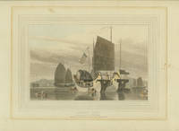
CHINA SHIPS Daniell Thos. & Willm. drawn and engraved by.
Chinese Junks.
London.: Messrs. Longman Hurst Rees & Orme. 09-01- 1810. Aquatint handcolored plate area 7 1/4 x 9 3/4 inches on sheet size 9 1/2 x 13 inches adhered to backing board. Color faded toning around plate mark from previous matting a few small scattered spots. Attractive view of junk boats at anchor. . Messrs. Longman, Hurst, Rees & Orme. unknown
Referentie van de boekhandelaar : 51037
|
|
|
CHINA / INDIA Heaney GF.; Ray G. Johnson. G. F.
The National Geographic Magazine. 1944 - 06.
Washington D.C.: National Geographic Society. 06- 1944. June 1944 issue of the magazine in paper wrappers as issued 1 inch tear to tail of spine 1/4 inch split to head of spine overall very good condition. Interesting article: 'Exploring a Grass Wonderland of Wild West China' by Johnson of a journey in Sikang with fascinating pictures; pictures of Manipur 'where Japan struck at India.' . National Geographic Society. unknown
Referentie van de boekhandelaar : 34328

|
|
|
CHINA DECORATIVE ART
Ornements de la Chine. Plate 12. Chinese cloisonne covered vase.
Paris.: Canson Libraire-Editeur. 1883. Chromolithograph image area approximately 13 x 8 inches on sheet 24 1/2 x 18 inches. Very light scattered foxing in image area scarcely noticeable; two edge tears two chips to paper at edge of sheet but all 4 or more inches from image area. Richly colored with gold design work. This is plate 12 from the exquisitely printed French portfolio Ornements de la Chine Recueil de Dessins Pour l'Art et l'Industrie par E. Collinot et A. De Beaumont featuring Chinese ornament of which only 500 copies were issued. . Canson, Libraire-Editeur. unknown
Referentie van de boekhandelaar : 38103

|
|
|
CHINA
China Making. China-Wheel. China Manufactory. THREE ENGRAVINGS.
London.: J. J. Stockdale. 1812. Engravings handcolored sheet size 4 1/4 x 6 7/8 inches one landscaper & two portrait. Each has light soiling two pieces of tape on verso of top margin outside image area. THREE SHEETS from an edition of Breton de la Martiniere "China: Its Costume Arts Manufactures &c." Engraved by A. Freschi and very attractively handcolored. Partial watermark on two sheets. . J. J. Stockdale. unknown
Referentie van de boekhandelaar : 40315

|
|
|
CHINA SHANGHAI Ke Lang edited by. Shao Cheng illus.
New Map of Shanghai. Pocket Edition. 1945.
Shanghai.: Asia Geographical Institute. 1945. 1st edition. Large color folding map 19 1/4 x 28 on sheet 21 x 29 1/2 inches folding out of cloth covered boards. Minor misfolding to the map resulting in a few extra creases but otherwise map is in very good condition with no tears. Few soiled spots to back cover of boards. There are four inset maps: "Shanghai Central of Municipal District" 3 3/4 x 3 inches; "Native City" 6 x 4 1/2 inches; "Central District" 8 x 9 inches; "Western District Extension" 3 3/4 x 4 1/2 inches. The map is on a scale of 1 :24000. Railways tramways bus routes are marked and the names of the wharves along the river. Major firms banks etc are named on the map of the central district. An attractive and detailed map of this cosmopolitan city. "Issued by Ya Kwang Geographical Institute". Marked "First Edition 1945" at lower left. Publisher is stated as the Asia Geographical Institute on the map and the East Asia Geographical Institute on the cover. Price is stated as '$600.00'. . Asia Geographical Institute. hardcover
Referentie van de boekhandelaar : 38714

|
|
|
CHINA CUSTOMS
Life on a Chinese Houseboat.
London.: The Graphic. 08-03- 1889. Full page wood engraving from The Graphic magazine August 3 1889. Faint toning to edges; very good condition. This antique print showing A Trip in a Chinese House Boat features six vignette illustrations: "We Are Mistaken for Smugglers" "Thank Goodness Dog is an Article of Diet Here" "The wit of the village discourses on the Barbarian Toilet" "A Little Argument" "Some of the Crew" and "Rivals rapidly approaching our shooting ground. Five minutes for Tiffin.The fowl is adamant." . The Graphic. unknown
Referentie van de boekhandelaar : 44230

|
|
|
CHINA BEIJING Parish HW. mapmaker. B. Baker engraver. H. W.
Sketch of the Pay-ho or White River and of the Road from Pekin to Geho taken 1793.
London.: George Nicol. 1796. Copperplate engraved map 17 1/4 x 13 inches 44 x 33 cm uneven left margin 1/4 inch at most narrow toning at edge of sheet well outside image overall very good condition. Finely engraved and detailed map of two routes to Pekin Beijing along the White River Baihe River and along the Imperial Highway from Jehol. The map was published in the account of the 1st Earl Macartney's embassy to China 1792-1794 An Authentic Account of an Embassy from the King of Great Britain to the Emperor of China written by George Staunton. The map has a scale in nautical miles and in English Miles. Much interesting commentary locating palaces and gardens type of cultivation etc. . George Nicol. unknown
Referentie van de boekhandelaar : 41641

|
|
|
CHINA BEIJING
A Boys' School Pekin.
London.: Illustrated London News. 03-01- 1873. Full-page wood engraving black and white from The Illustrated London News March 1 1873 image size 8 1/2 x 12 1/4 on sheet 11 x 16 inches. Very good condition. View of young Chinese pupils and their instructor in a classroom at the London Missionary Society. Verso includes a brief article "A Boys' School at Pekin". . Illustrated London News. unknown
Referentie van de boekhandelaar : 48656

|
|
|
CHINA BEIJING Child G. engraved by.
The Great Imperial Throne from Le Comte.
London. 1745- 1747. Copperplate engraving image 6 x 9 inches 15 x 23 cm on sheet 7 3/4 x 10 1/4 inches fine condition. An attractive view of the Great Imperial Throne in the Forbidden City Beijing China after the work of Le Comte. This engraving was published in an 18th century compendium of important travel writing: "A New General Collection of Voyages and Travels" published by Astley. . unknown
Referentie van de boekhandelaar : 44183

|
|
|
CHINA HUBEI / HUNAN Child G. engraved by.
Cities of Hu-Quang.
London. 1745- 1747. Copperplate engraving image 6 x 8 3/4 inches 15 x 22 cm on sheet 10 1/4 x 16 1/2 inches fine condition. Map of the principal cities of the province of Huguang now the present day provinces of Hubei and Hunan. This engraving was published in an 18th century compendium of important travel writing: "A New General Collection of Voyages and Travels" published by Astley. . unknown
Referentie van de boekhandelaar : 43850

|
|
|
FLORIDA / CHINA / RADIO Moller Hans cover illus.
Fortune Magazine. 1948 - 02.
NY.: Time. Volume XXXVII. Number 2. 02- 1948. February 1948 complete issue of magazine profusely illustrated in color and black and white 215pp 13 x 10 1/2 inches color pictorial paper wrappers as issued. Covers lightly worn spine cocked and rubbed; otherwise good clean condition. Many interesting articles in this beautiful publication plus elegant color and black and white advertisements. Articles include "State of Florida: It is booming and busting whooping and worrying. It is the U.S. 1948 - in a distorted mirror" "Edison Bros. Shoes" "Armstrong of Radio" "The Tyrannous Decade: How the U.S. managed in only ten years to empty a century-old reservoir of good will in China" etc. Florida-related color cover by Hans Moller. . Time. unknown
Referentie van de boekhandelaar : 45349

|
|
|
CHINA / TAIWAN SURVIVAL MAP/ EVASION MAP/ ESCAPE MAP
AAF Cloth Map - Asiatic Series. No. 34. Southeast China. No. 35. Northeast China.
Washington D.C.: Army Map Service. 07- 1945. Two color maps 23 1/2 x 19 inches printed back to back on one cloth sheet 25 1/2 x 20 1/2 inches folded as issued. Very good clean condition: few very light spots to lower edge little fraying at edges. This is an "evasion" "survival" or "escape" vintage map compiled for the U.S. Army Air Forces; these light-weight "silk" maps actually most were man-made fabrics were carried by military personnel with missions in enemy territory each map containing information crucial to facilitating escape to friendly territory. The South China side has an inset of Taiwan Formosa. Topography indicated with linear hatching; winds and ocean currents are marked as well as much information on settlements and terrain. Appears to be a 1945 issue. Scale 1:2000000. Map No. 34 includes approximate coordinates: 112 to 122 degrees east and 22 to 32 degrees north. Map No. 35 includes approximate coordinates 109 to 123 degrees east and 30 to 38 degrees north. "Compiled for the U.S. Army Air Forces by the Army Map Service.November 1943" at lower left of sheet 34 but at lower right 1944 date and smaller 7/45 notation. Northeast China side is marked RESTRICTED. . Army Map Service. hardcover
Referentie van de boekhandelaar : 40456

|
|
|
CHINA SHANGHAI
Going to the Derby at Shanghai IN COMPLETE ISSUE OF HARPER'S WEEKLY.
New York.: Harper's Weekly. 06-14- 1879. Wood engraving double page centerfold illustration sheet 16 1/2 x 23 inches with text under image in COMPLETE ISSUE of Harper's Weekly magazine June 14 1879. Issue never bound a few short edge tears overall very good condition. WITH SUPPLEMENT. The text reads in part: "it is proverbial that Englishmen are so passionately fond of horse-racing that wherever they assemble in numbers they are sure to introduce their favorite pastime. China is no exception and the interest it excites amongst the natives leads one to suppose that it is an amusement suitable to the temperament of the nation." This issue includes a back page cartoon by Bellew 4 1/2 inches square purportedly "Copied from a Cartoon in a recent number of the "Pekin Illustrated Weekly" from the "Melican" man series of a Chinese laundry worker refusing to be interviewed: "Chinaman workee Chinaman no talkee no gabbee." There also are two half page illustrations from the Blackville series stereotype images of African Americans: The Blackville Medical Man and The Blackville School-master. The Supplement contains a double page illustration: Epsom Downs - "List Men" on Derby-Day; and a single page collage of illustrations with article Life and Scenery on the River Niger. . Harper's Weekly. unknown
Referentie van de boekhandelaar : 43899

|
|
|
KOREA SEOUL / CHINA SHANGHAI
Japan. 1923 - 07.
Volume XII Number 10. 07- 1923. Complete July 1923 issue of magazine 56pp 12 1/4 x 9 1/4 inches color pictorial wrappers as issued. Covers lightly soiled with a few 1/8 inch edge tears otherwise in very good condition. Contains many interesting articles and advertisements including: "The Other Side of the Earth. Part II. Seoul to Shanghai" by Margaret Nessly plus an ad for The Hot Springs of Japan And the Principal Cold Springs. "This magazine is distributed through tourist and ticket agencies in the United States Honolulu Japan China India Australia the Philippines and other countries. In addition it is circulated on steamers of the Toyo Kisen Kaisha and other S.S. Lines". Each issue of Japan magazine includes a back cover advertisement for Toyo Kisen Kaisha. . unknown
Referentie van de boekhandelaar : 40909

|
|
|
CHINA SURVIVAL MAP/ EVASION MAP/ ESCAPE MAP
Kweilin. Fu-Chou.
War Office. 1957. Two color maps printed back to back on one fabric sheet 25 1/2 x 28 inches folded as issued. Very good condition. This fabric map also loosely described as a "silk" map is an "evasion" "survival" or "escape" map compiled for the British forces during the Cold War era and printed by the British game manufacturer John Waddington Ltd. These light-weight maps issued in large quantities during the Second World War contained information to facilitate escape to friendly territory. At a scale of 1:1000000 1 inch to 13.71 miles the Kweilin map covers the area from coordinates 108 to 114 degrees east and 24 to 28 degrees north a large portion of southern China just north of Canton. The map of Fu-Chou covers the area from coordinates of 114 to 120 degrees east and 24 to 28 degrees north a large portion of southern China just north of Hong Kong. The topography is indicated with contour lines. There is great detail with marshes lakes coral reefs etc marked. Both sides are marked RESTRICTED. . War Office. unknown
Referentie van de boekhandelaar : 41095

|
|
 De zoekresultaten per email ontvangen
 Zoekresultaten downloaden als PDF
 RSS feed


