|
|
|
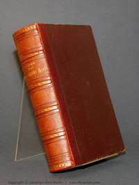
Jacques Normand
Paravents et tréteaux, fantaisies de salon et de Théâtre
Le chapeau, Le fou rire, On dansera, Si j'étais Femme, Les écrevisses, Elle est jolie, La Gervaise, La farce de la Cronette, etc. bel envoi autographe de l'auteur à " mon ami G. Raynaud, ma sympathie. " volume relié, in8, demi cuir, 18x11, très bon état intérieur, 244pp. Couvertures d'origines conservées. Paris, Calman Lévy, 1881. Edition Originale ref/293
Référence libraire : CZC-12561

|
|
|
Jacques Normand
Paravents et tréteaux, fantaisies de salon et de Théâtre
Le chapeau, Le fou rire, On dansera, Si j'étais Femme, Les écrevisses, Elle est jolie, La Gervaise, La farce de la Cronette, etc. bel envoi autographe de l'auteur à " mon ami G. Raynaud, ma sympathie. " volume relié, in8, demi cuir, 18x11, très bon état intérieur, 244pp. Couvertures d'origines conservées. Paris, Calman Lévy, 1881. Edition Originale ref/293
Référence libraire : CZC-12561
|
|
|
Jacques Offenbach
La Belle Helene: Scottish Opera Programme
Glasgow: Scottish Opera 1995 Book condition: Near Fine with just a hint of sunning to edges. 32 pages. Tickets for performance at Theatre Royal Glasgow loosely inserted. A bright copy. Scottish Opera paperback
Référence libraire : 001213
|
|
|
Jacques Paget
Debout l'Europe
Le Livre Contemporain 1957 246 pages in8. 1957. broché. 246 pages.
Référence libraire : 10005

|
|
|
JACQUES Pierre
Les sources du Conflit Européen de 1914
Paris, Editions & Librairie, Librairie Paris, Editions & Librairie, Librairie aéronautique, 1915. In-8 broché de 318 pages. Couverture jaunie avec petite tache. Peu courant.
Référence libraire : 148389

|
|
|
JACQUES Pierre
Les sources du Conflit Européen de 1914
Paris, Editions & Librairie, Librairie aéronautique, 1915. In-8 broché de 318 pages. Couverture jaunie avec petite tache. Peu courant.
|
|
|
Jacques Ranciere
The Nights of Labor: The Workers' Dream in Nineteenth-Century France
Philadelphia: Temple University Press 1989. First edition. hardcover. very good/very good. 8vo. pp.442. Temple University Press hardcover
Référence libraire : 330834 ISBN : 0877226253 9780877226253
|
|
|
Jacques Revel,Lynn Hunt
Histories: French Constructions of the Past Postwar French Thought
New york: New Press 1995. First edition. hardcover. very good/very good. 8vo. pp.654. New Press hardcover
Référence libraire : 326346 ISBN : 1565841956 9781565841956
|
|
|
Jacques Sole
Questions of the French Revolution: A Historical Overview
New york: Pantheon Books 1990. Firs tedition. paperback. very good/no dustjacket. 8vo. pp.316 Pantheon Books paperback
Référence libraire : 331828 ISBN : 0679725636 9780679725633

|
|
|
Jacques, David
GEORGIAN GARDENS : The Reign of Nature
Timber Press 1984. 240pp. Green cloth hardback DJ VG flaps glued to inside covers EX-LIB minimal markings indices bibliography chapter notes b&w and color photos and illustrations Includes: The birth of the natural style The progress of taste The heyday of the natural style Strictures on landscape gardening Repton and the picturesque Regency gardens . Hard Cover. Very Good/Very Good. Timber Press Hardcover
Référence libraire : w180825660 ISBN : 0917304918 9780917304910
|
|
|
JACR. J. A. C. R.
The Colleges of Oxford: with twenty two reproductions in colour and monochrome from 19th century prints and nine drawings
The Ariel Press 1964. Paperback. xVery Good paperback light foxing to outer covers internally fine - clean and unmarked in Good dustwrapper chipped and edgeworn esp. to top edge in Good only glassine wrapper edgeworn chipped with small losses. Paperback. Illustrated. The picture on the listing page is of the actual book for sale. The Ariel Press paperback
Référence libraire : 45883
|
|
|
Jaeckle, Erwin
Die Idee Europa.
Frankfurt/Berlin, Propyläen, 1988. 8°, 399 Seiten. Orig.Pappband mit OSU.
Référence libraire : 19116
|
|
|
Jaeger, C. Stephen
The Origins of Courtliness: Civilizing Trends and the Formation of Courtly Ideals 939-1210 The Middle Ages Series
University of Pennsylvania Press 1985-09-01. Paperback. Like New. Prompt shipment with tracking. we ship in CLEAN SECURE NEW boxes name in ink. University of Pennsylvania Press paperback
Référence libraire : WARE1321115 ISBN : 0812213076 9780812213072
|
|
|
Jaeger, Marc A
Die Zukunft des Abendlandes.
Bern, Francke Verlag, 1963. 270 S. Gr.-8° Groß-Oktav, Leinen
Référence libraire : 100676

|
|
|
JAEKEN, Godfried - WESTERLING, Hans.
L'Ecosse.
Bruxelles, éd. Artis - Historia, 1994, gd. in-4, cartonnage toilé éd., jaquette photo en coul. éd., 106 pp., 1 cartes en coul. et très nb. chromos contrecollés en coul., Table des matières, Très beau voyage en Ecosse. Bien complet des chromos. Très bon état
Référence libraire : 65909
|
|
|
Jaenen, Cornelius J., Editor
The French Regime in the Upper Country of Canada during the Seventeenth Century The Publications of the Champlain Society
Champlain Society in co-operation with the Government of Ontario 1996 Book. Very Good. Hardcover. A nice copy with minimal wear. 303 pages illustrated. Volume from The Ontario Series from The Champlain Society. Champlain Society in co-operation with the Government of Ontario hardcover
Référence libraire : 109389 ISBN : 0969342578 9780969342571
|
|
|
JAFFE,HLC. H. L.
Over utopie en werkelijkheid in de beeldende kunst. Verzamelde opstellen van H.L.C. Jaffé 1915-1984. Samengesteld door A.W. Reinink E. van Voolen & J.H. Sassen.
Amst. Meulenhoff/Landhoff 1986. 304 p. ills. Pb. 22 cm Small wrinkle in frontcover unknown
Référence libraire : 116745
|
|
|
Jaffé H. L. C.
Per un'arte nuova. De Stijl 1917-1931
8 tavole a colori e 47 illustrazioni in nero

|
|
|
Jagendorf, Siegfried;Hirt-Manheimer, Aron
Jagendorf's Foundry: Memoir of the Romanian Holocaust 1941-1944
Harpercollins 1991. Hardback. Fine/Very Good. <br/> <br/> Harpercollins hardcover
Référence libraire : 334852 ISBN : 006016106x 9780060161064

|
|
|
Jahn, Bernhard (Herausgeber)
Zeremoniell in der Krise : Störung und Nostalgie. Zum 60. Geburtstag von Jörg Jochen Berns. ERSTAUSGABE.
Marburg : Jonas-Verlag, 1998. 160 Seiten. Mit zahlreichen Schwarz-Weiß- Abbildungen. 25 cm Originalpappband.
Référence libraire : 283850

|
|
|
Jahn, C. F
Illustrirtes Reisebuch 1850. Ein Führer durch Deutschland, die Schweiz, Tyrol, Italien und nach Paris, London, Brüssel, Amsterdam, Kopenhagen, Stockholm, Warschau. Mit einer Reisekarte von Deutschland und über 300 Ansichten. Unter Mitbenutzung amtlicher Quellen herausgegeben von C. F. Jahn. Neue bis April 1850 ergänzte und berichtigte Ausgabe, Reprint der Originalausgabe Berlin 1850 [mit entnehmbarer Faltkarte]
Leipzig: Zentralantiquariat der Deutschen Demokratischen Republik, 1985. 16 cm ; Leinen
Référence libraire : 105095

|
|
|
Jahn, Hajo [Hrsg.]
Zwischen Theben und Shangai: Jüdische Exilanten in China - Chinesische Exilanten in Europa Almanach zum V. Else-Lasker-Schüler-Forum 'Flucht in die Freiheit' 1. Aufl.
Chemnitz, Berlin, St. Petersburg: Oberbaum Verlag 1998. 258 S., mit schw/w Abb., 23cm x 14cm Leinen
Référence libraire : 6400549
|
|
|
Jahns, Max.
Das französische Heer von der grossen Revolution bis zur Gegenwart: Eine kulturhistorische Studie.
Leipzig Grunow 1873. 1st Edition . Hardcover. . ~ ~ NOTE: THE PRICE OF THIS BOOK IS CURRENTLY REDUCED! ~ ~ . Octavo. Pp. xvi 800. Footnotes. Set in Gothic type. HARDCOVER bound in contemporary half calf spine with gilt raised bands between compartments blind tooling along boards marbled edges top of joint tender. In about fine condition. ~ FIRST EDITION. From the contemporary library of Master of Laws F. C. Koch with his handsome bookplate. TIMO-1 OUT <br/> <br/> Leipzig, Grunow hardcover
Référence libraire : 0611
|
|
|
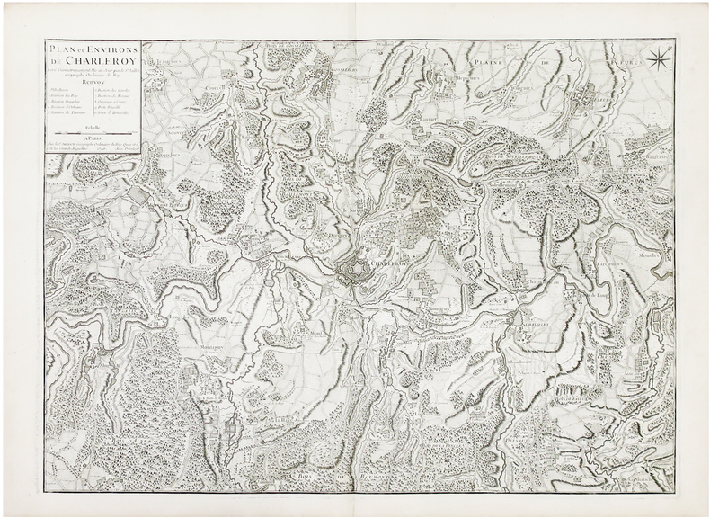
JAILLOT (Bernard).
[BELGIQUE] Plan et environs de Charleroy.
Paris, Sr. Jaillot, 1746. 480 x 666 mm.
Référence libraire : LBW03939
|
|
|
JAILLOT Alexis Hubert (1632 - 1712)
Estats De L'Empire du Grand Seigneur des Turcs en Europe, ou sont les Beglerbeglicz ou Gouverne de Romelie, de la Mer, de Bu
Dettagliata carta dell'Impero Turco e del Mediterraneo. Si estende dalla penisola arabica e l'impero di Persia a est fino alle baleari e a ovest fino all'Italia e alla Francia.Incisione su rame, in ottimo stato di coonservazione. Highly detailed engraved chart of the Turkish Empire, and Mediterranean, from Hubert Jaillot. Extends from the Arabian Peninsula and the Empire of Persia in the east to Algeria, the Balearic Islands, Italy and France in the west. Includes an elaborate cartouche, coast of arms.

|
|
|
JAILLOT Alexis Hubert (1632 - 1712)
L'Europe divisée suivant l'estendue de ses Principales Parties…
Titolo originale: "L'EUROPE / DIVISÉE SUIVANT L'ESTENDUE / DE SES PRINCIPALES PARTIES / SUBDIVISÉES EN LEURS PRINCIPALES PROVINCES / sur les Memoires les plus nouveaux / DEDIÉE / A MONSEIGNEUR LE DUC DE BOURGOGNE / Par son tres humble et tres obeissant Serviteur / HUMBERT IAILLOT Geographe du Roy / 1718." Grande carta murale in 6 fogli edita da Jaillot a Parigi nel 1718. Basata sulla cartografia di Nicolas Sanson, l'opera è un ingrandimento delle carte inserite negli atlanti di Sanson prima e Jaillot poi.Incisione in rame, coloritura coeva con ritocchi, sei fogli uniti e montati su tela, difetti minori ai margini, nel complesso in ottimo stato di conservazione.Scala di: 300.000 passi geometrici, 250 miglia d'Inghilterra, 60 leghe di Svezia, 125 leghe di Francia, 75 leghe di Germania, 100 leghe di Polonia, 90 leghe di Spagna, 300 miglia d'Italia, 50 leghe d'Ungheria, 400 leghe di Mosca, 100 leghe d'un'ora di cammino, 10 diete o giornate = cm. 11,4.Ottimo esempalrae di questa rarissima carta murale dell'Europa. "L'EUROPE / DIVISÉE SUIVANT L'ESTENDUE / DE SES PRINCIPALES PARTIES / SUBDIVISÉES EN LEURS PRINCIPALES PROVINCES / sur les Memoires les plus nouveaux / DEDIÉE / A MONSEIGNEUR LE DUC DE BOURGOGNE / Par son tres humble et tres obeissant Serviteur / HUMBERT IAILLOT Geographe du Roy / 1718." Large wall map in 6 sheets published by Jaillot in Paris in 1718. Based on the cartography of Nicolas Sanson, the work is an enlargement of the maps inserted in the atlas of Sanson and Jaillot before then. Copper engraving, contemporary colouring with touches, six sheets joined together and mounted on canvas, minor defects to margins, otherwise in excellent condition. Great esemple of this rare wall map of Europe.

|
|
|
JAILLOT Alexis Hubert (1632 - 1712)
La Mer Mediterranée divisée en mer de levant et de ponant, subdivisées en leurs principales parties ou mers…
Carta del Mediterraneo stampata a Parigi da Alexis Hubert Jaillot.Questo abile uomo d’affari nacque verso il 1632 ad Avignon-lès-Saint-Claude. Dall’infanzia Jaillot aveva mostrato un buon talento per l’arte e il disegno e da suo fratello Pierre-Simón aveva imparato la scultura. Durante il conflitto franco-spagnolo la loro città natale fu devastata, e così i due fratelli si trasferirono a Parigi nel 1657. Lì acquisirono presto una certa reputazione e il titolo di “Sculpteur du Roy”. Nel 1665, Jaillot si sposò con Jeanne Berey, figlia di Nicolas I Berey. La fortuna di Jaillot fu di entrare nel mercato cartografico in un momento particolarmente favorevole. All’inizio del 1668, sotto Luigi XIV, per la Francia iniziò un periodo particolarmente fecondo, come conseguenza della costante espansione territoriale c’era una grande richiesta di mappe che rappresentassero le conquiste francesi e le nuove frontiere. In seguito, Jaillot si associò con i figli di Nicolas Sanson, e fu in grado di commercializzare nuove carte con il prestigioso nome Sanson. Il suo atlante del 1681, l’Atlas Nouveau, divenne un tale successo commerciale che fu copiato illegalmente da altri editori. Jaillot non può essere annoverato tra i cartografi dell’epoca come i Sanson e Duval, fu però un abile incisore che seppe intelligentemente sfruttare le risorse che aveva ereditato, facendone opere mirabili. La sua fama crebbe al punto che il 20 luglio 1686 fu nominato “Géographe du Roy” e gli fu assegnata una cospicua pensione annuale; il titolo gli consentì di difendersi dai numerosi contraffattori. Una delle sue opere più belle fu Le Neptune François, o Atlas Nouveau des Cartes Marine. Dall’inizio del diciottesimo secolo la sua produzione di carte diminuì: erano richieste mappe sempre più aggiornate che non era in grado di offrire. D’altronde, i concorrenti più giovani erano geografi del calibro di Guillaume Delisle. Jaillot (m. 1712) cedette, quindi, l’azienda a suo figlio Bernard Jean-Hyacinthe.Incisione in rame coloritura coeva dei contorni, lievissime tracce di colla nelle pieghe centrali, per il resto in otitmo stato di conservazione. Map of the Mediterranean sea printed in Paris by Alexis Hubert Jaillot.Copperplate, with outline original colouring, good condition.Alexis Hubert Jaillot born around 1632 in Avignon-lès-Saint-Claude. Since childhood Jaillot had shown a good talent for art and drawing and had learned sculpture from his brother Pierre-Simón. During the Franco-Spanish conflict their hometown was devastated, and so the two brothers moved to Paris in 1657. There they soon acquired a certain reputation and the title of "Sculpteur du Roy". In 1665, Jaillot married with Jeanne Berey, daughter of Nicolas I Berey. Jaillot's fortune was to enter the cartographic market at a particularly favorable time. At the beginning of 1668, under Louis XIV, a particularly fruitful period began for France, as a consequence of the constant territorial expansion there was a great demand for maps that represented French conquests and new frontiers.Later, Jaillot joined forces with the sons of Nicolas Sanson, and was able to market new maps with the prestigious Sanson name. His Atlas of 1681, the "Atlas Nouveau", became such a commercial success that it was illegally copied by other publishers. Jaillot cannot be counted among the cartographers of the time such as the Sansons and Duval, but he was a skilled engraver who was able to intelligently exploit the resources he had inherited, making them wonderful works. His fame grew to the point that on 20 July 1686 he was named "Géographe du Roy" and was given a large annual pension; the title allowed him to defend himself against numerous counterfeiters.

|
|
|
JAILLOT Alexis Hubert (1632 - 1712)
Nouvelle Carte Marine de tous les Ports de l’Europe sur l’Océan et la Méditerranée
Nouvelle Carte Marine de tous les Ports de l’Europe sur l’Océan et la Méditerranée. Gravée et présentée à Monseigneur Phelypeaux, Conseiller du Roy en tous ses conseils, Secrétaire d’Estat, et des Commandemens de sa Maiesté, avant le Département de la Marine. Acquaforte, dimensioni 520x765 mm, firmata in lastra nel cartiglio per il titolo Par son tres humble et tres obeissant Serviteur Berey. In basso a sinistra, la firma dell’incisore, Gravée par Berey, e sotto l’imprint editoriale, A Paris Chés le S.r Jaillot Géographe ordinaire du Roy sur le Quay et a coté des grands Augustins.Bellissimo esemplare, con coloritura coeva dei contorni, nel primo stato di tre.Carta tratta da: Atlas François, contenant les cartes géographiques dans lesquelles sont très exactement remarquez les Empires, Monarchies, Royaumes et Estats de l’europe, de l’Asie, de l’Afrique et de l’Amerique […] à Hubert Jaillot, geographe ordinaire de sa Majesté.Carta nautica dell’Europa, incisa da Claude Auguste Berey, la cui firma appare sia nel cartiglio che nell’angolo in basso a sinistra. L’opera è dedicata a Jérôme Phélypeaux de Pontchartrain (1674 - 1747), segretario di Stato del Re e segretario di Stato della Marina dal 6 settembre 1699 al 1 di ottobre 1715. Alla morte di Nicolas II, a capo della tipografia Berey si insediò Alexis Hubert Jaillot. Questo abile uomo d’affari nacque verso il 1632 ad Avignon-lès-Saint-Claude. Dall’infanzia Jaillot aveva mostrato un buon talento per l’arte e il disegno e da suo fratello Pierre-Simón aveva imparato la scultura. Durante il conflitto franco-spagnolo la loro città natale fu devastata, e così i due fratelli si trasferirono a Parigi nel 1657. Lì acquisirono presto una certa reputazione e il titolo di “Sculpteur du Roy”. Nel 1665, Jaillot si sposò con Jeanne Berey, figlia di Nicolas I Berey. La fortuna di Jaillot fu di entrare nel mercato cartografico in un momento particolarmente favorevole. All’inizio del 1668, sotto Luigi XIV, per la Francia iniziò un periodo particolarmente fecondo, come conseguenza della costante espansione territoriale c’era una grande richiesta di mappe che rappresentassero le conquiste francesi e le nuove frontiere. In seguito, Jaillot si associò con i figli di Nicolas Sanson, e fu in grado di commercializzare nuove carte con il prestigioso nome Sanson. Il suo atlante del 1681, l’Atlas Nouveau, divenne un tale successo commerciale che fu copiato illegalmente da altri editori. Jaillot non può essere annoverato tra i cartografi dell’epoca come i Sanson e Duval, fu però un abile incisore che seppe intelligentemente sfruttare le risorse che aveva ereditato, facendone opere mirabili. La sua fama crebbe al punto che il 20 luglio 1686 fu nominato “Géographe du Roy” e gli fu assegnata una cospicua pensione annuale; il titolo gli consentì di difendersi dai numerosi contraffattori. Una delle sue opere più belle fu Le Neptune François, o Atlas Nouveau des Cartes Marine. Dall’inizio del diciottesimo secolo la sua produzione di carte diminuì: erano richieste mappe sempre più aggiornate che non era in grado di offrire. D’altronde, i concorrenti più giovani erano geografi del calibro di Guillaume Delisle. Jaillot (m. 1712) cedette, quindi, l’azienda a suo figlio Bernard Jean-Hyacinthe.Claude Auguste Berey (1651 - 1732) era un maestro scrittore calligrafo, incisore e commerciante di stampe francesi; secondo figlio di Nicolas I Berey e della sua seconda moglie Marie Trémison e fratellastro di Nicolas II Berey (1640 - 1667), lavorò in seguito per Alexis-Hubert Jaillot. Attivo tra il 1690 e il 1730, Claude Auguste stesso incise diverse tavole per le carte geografiche del Le Neptune François, o Atlas Nouveau des Cartes Marine. Intorno al 1697 aveva una bottega di stampe in rue Saint-Jacques, all’insegna della Principessa di Savoia. La carta è databile al 1699 - 1700, appena Phélypeaux venne incaricato; alcune p... Nouvelle Carte Marine de tous les Ports de l’Europe sur l’Océan et la Méditerranée. Gravée et présentée à Monseigneur Phelypeaux, Conseiller du Roy en tous ses conseils, Secrétaire d’Estat, et des Commandemens de sa Maiesté, avant le Département de la Marine. Etching, signed in the cartouche by the engraver Nicolas Berey II: Par son tres humble et tres obeissant Serviteur Berey. At lower left we find again the engraver's signature and the imprint A Paris Chés le S.r Jaillot Géographe ordinaire du Roy sur le Quay et a coté des grands Augustins.A fine impression, of the first state of three, with contemporary outline colour, very good condition.Taken from: Atlas François, contenant les cartes géographiques dans lesquelles sont très exactement remarquez les Empires, Monarchies, Royaumes et Estats de l’europe, de l’Asie, de l’Afrique et de l’Amerique […] à Hubert Jaillot, geographe ordinaire de sa Majesté.Nautical chart of Europe, engraved by Claude Auguste Berey, whose signature appears both in the cartouche and in the lower left corner. The work is dedicated to Jérôme Phélypeaux de Pontchartrain (1674 - 1747), Secretary of State of the King and Secretary of State of the Navy from 6 September 1699 to 1 October 1715.On the death of Nicolas II, Alexis Hubert Jaillot took over as head of the printing house Berey. This skilled businessman was born around 1632 in Avignon-lès-Saint-Claude. Since childhood Jaillot had shown a good talent for art and drawing and had learned sculpture from his brother Pierre-Simón. During the Franco-Spanish conflict their hometown was devastated, and so the two brothers moved to Paris in 1657. There they soon acquired a certain reputation and the title of "Sculpteur du Roy". In 1665, Jaillot married with Jeanne Berey, daughter of Nicolas I Berey. Jaillot's fortune was to enter the cartographic market at a particularly favorable time. At the beginning of 1668, under Louis XIV, a particularly fruitful period began for France, as a consequence of the constant territorial expansion there was a great demand for maps that represented French conquests and new frontiers.Later, Jaillot joined forces with the sons of Nicolas Sanson, and was able to market new maps with the prestigious Sanson name. His Atlas of 1681, the "Atlas Nouveau", became such a commercial success that it was illegally copied by other publishers. Jaillot cannot be counted among the cartographers of the time such as the Sansons and Duval, but he was a skilled engraver who was able to intelligently exploit the resources he had inherited, making them wonderful works. His fame grew to the point that on 20 July 1686 he was named "Géographe du Roy" and was given a large annual pension; the title allowed him to defend himself against numerous counterfeiters. One of his most beautiful works was "Le Neptune François, or Atlas Nouveau des Cartes Marine". From the beginning of the eighteenth century its map production decreased: more and more updated maps were required which it was not able to offer; Jaillot (d. 1712) ceded, therefore, the company to his son Bernard Jean-Hyacinthe.Claude Auguste Berey (1651 - 1732) was a master calligrapher writer, engraver and dealer of French prints; second son of Nicolas I Berey and his second wife Marie Trémison and half-brother of Nicolas II Berey (1640 - 1667), he later worked for Alexis-Hubert Jaillot. Active between 1690 and 1730, Claude Auguste himself engraved several plates for "Le Neptune François, or Atlas Nouveau des Cartes Marine".Around 1697 he had a print shop in the rue Saint-Jacques, under the banner of the Princess of Savoy.Themap can be dated to 1699 - 1700, as soon as Phélypeaux was commissioned; some examples of the work show, in the lower left corner, the imprint: Se Vend a Paris chez Iaillot le fils sur le Quay de l'Orloge du Palais; these are the runs of Bernard Jean-Hyacinthe Jaillot. The map had a further reprint from Louis Denis's typography.B... S. Bifolco, "Mare Nostrum, Cartografia nautica a stampa del Mar Mediterraneo" (2020), pp. 248-249, tav. 115.

|
|
|
JAILLOT Alexis Hubert (1632 - 1712)
Nouvelle carte Marine de tous les Ports de l’Europe sur l’Ocean et sur la Mediterranée...
Nouvelle Carte Marine de tous les Ports de l’Europe sur l’Océan et la Méditerranée. Gravée et présentée à Monseigneur Phelypeaux, Conseiller du Roy en tous ses conseils, Secrétaire d’Estat, et des Commandemens de sa Maiesté, avant le Département de la Marine. Acquaforte, dimensioni 520x765 mm, firmata in lastra nel cartiglio per il titolo Par son tres humble et tres obeissant Serviteur Berey. In basso a sinistra, la firma dell’incisore, Gravée par Berey, e sotto l’imprint editoriale, A Paris Chés le S.r Jaillot Géographe ordinaire du Roy sur le Quay et a coté des grands Augustins.Bellissimo esemplare, con coloritura coeva dei contorni, nel primo stato di tre.Carta tratta da: Atlas François, contenant les cartes géographiques dans lesquelles sont très exactement remarquez les Empires, Monarchies, Royaumes et Estats de l’europe, de l’Asie, de l’Afrique et de l’Amerique […] à Hubert Jaillot, geographe ordinaire de sa Majesté.Carta nautica dell’Europa, incisa da Claude Auguste Berey, la cui firma appare sia nel cartiglio che nell’angolo in basso a sinistra. L’opera è dedicata a Jérôme Phélypeaux de Pontchartrain (1674 - 1747), segretario di Stato del Re e segretario di Stato della Marina dal 6 settembre 1699 al 1 di ottobre 1715. Alla morte di Nicolas II, a capo della tipografia Berey si insediò Alexis Hubert Jaillot. Questo abile uomo d’affari nacque verso il 1632 ad Avignon-lès-Saint-Claude. Dall’infanzia Jaillot aveva mostrato un buon talento per l’arte e il disegno e da suo fratello Pierre-Simón aveva imparato la scultura. Durante il conflitto franco-spagnolo la loro città natale fu devastata, e così i due fratelli si trasferirono a Parigi nel 1657. Lì acquisirono presto una certa reputazione e il titolo di “Sculpteur du Roy”. Nel 1665, Jaillot si sposò con Jeanne Berey, figlia di Nicolas I Berey. La fortuna di Jaillot fu di entrare nel mercato cartografico in un momento particolarmente favorevole. All’inizio del 1668, sotto Luigi XIV, per la Francia iniziò un periodo particolarmente fecondo, come conseguenza della costante espansione territoriale c’era una grande richiesta di mappe che rappresentassero le conquiste francesi e le nuove frontiere. In seguito, Jaillot si associò con i figli di Nicolas Sanson, e fu in grado di commercializzare nuove carte con il prestigioso nome Sanson. Il suo atlante del 1681, l’Atlas Nouveau, divenne un tale successo commerciale che fu copiato illegalmente da altri editori. Jaillot non può essere annoverato tra i cartografi dell’epoca come i Sanson e Duval, fu però un abile incisore che seppe intelligentemente sfruttare le risorse che aveva ereditato, facendone opere mirabili. La sua fama crebbe al punto che il 20 luglio 1686 fu nominato “Géographe du Roy” e gli fu assegnata una cospicua pensione annuale; il titolo gli consentì di difendersi dai numerosi contraffattori. Una delle sue opere più belle fu Le Neptune François, o Atlas Nouveau des Cartes Marine. Dall’inizio del diciottesimo secolo la sua produzione di carte diminuì: erano richieste mappe sempre più aggiornate che non era in grado di offrire. D’altronde, i concorrenti più giovani erano geografi del calibro di Guillaume Delisle. Jaillot (m. 1712) cedette, quindi, l’azienda a suo figlio Bernard Jean-Hyacinthe.Claude Auguste Berey (1651 - 1732) era un maestro scrittore calligrafo, incisore e commerciante di stampe francesi; secondo figlio di Nicolas I Berey e della sua seconda moglie Marie Trémison e fratellastro di Nicolas II Berey (1640 - 1667), lavorò in seguito per Alexis-Hubert Jaillot. Attivo tra il 1690 e il 1730, Claude Auguste stesso incise diverse tavole per le carte geografiche del Le Neptune François, o Atlas Nouveau des Cartes Marine. Intorno al 1697 aveva una bottega di stampe in rue Saint-Jacques, all’insegna della Principessa di Savoia. La carta è databile al 1699 - 1700, appena Phélypeaux venne incaricato; alcune p... Sea chart of the Mediterranean sea, published by da Jaillot. Nicolas Berey (1606-1665), famous for his skills as painter of maps, became also engraver and, for a short period, he was also a publisher. He worked mainly in close contact with Nicolas Sanon’s workshop, his daughter married Alexis Hubert Jaillot. Copperplate, contemporary colour on the outlines, signs of humidity on upper part which partly damaged the engraving, in general in good condition.Very rare. S. Bifolco, "Mare Nostrum, Cartografia nautica a stampa del Mar Mediterraneo" (2020), pp. 248-249, tav. 115.

|
|
|
JAILLOT Alexis Hubert (1632 - 1712)
Nova Transilvaniae Principatus Tabula, ad Usum Serenissimi Burgundia Ducis
La mappa mostra la Transilvania, con rappresentazione dettagliata di tutte le città, foreste e montagne.La Transilvania è una regione storica situata in quella che oggi è la parte centrale della Romania.Acquaforte con bellissima colorazione originale, buone condizioni. Map shows Transylvania. With detailed representation of all cities, forests and mountains.Transilvania is a historical region located in what is today the central part of Romania.Copperplate, a fine impression with full original colouring, good condition.

|
|
|
Jake Arnott
L'irresistibile ascesa di Harry Starks
cartone edit. con titoli al dorso e sovrac. ill. - prima edizione it. - trad. di Delfina Vezzoli

|
|
|
Jakobeit, Cord (Hrsg.)
Gesamteuropa - Analysen, Probleme und Entwicklungsperspektiven. Schriftenreihe - Band 317 : Studien zur Geschichte und Politik
Bonn : Bundeszentrale für Politische Bildung, 1993. 740 S. kart., broschiert.
Référence libraire : 144360

|
|
|
Jakobs, Hermann
Kirchenreform und Hochmittelalter . 1046 - 1215. (= Grundriß der Geschichte, Band 7).
München, Wien. Oldenbourg, 1984. 288 S., Gr.-8°., Original-kartoniert,
Référence libraire : 481248
|
|
|
Jakobs, Hermann
Kirchenreform und Hochmittelalter : 1046 - 1215. Oldenbourg Grundriss der Geschichte ; Bd. 7.
München ; Wien : Oldenbourg, 1984. 288 S. : graph. Darst. ; 24 cm. Originalhardcover.
Référence libraire : 1077042

|
|
|
Jakobs, Hermann
Kirchenreform und Hochmittelalter. 1046 - 1215.
München/Wien, Oldenbourg, 1984. 24 cm. 288 S. : graph. Darst. kart. Sauber u. gut erhalten. 1 Biblioth.-Stemp. a. Tit.-Bl. Oldenbourg - Grundriß der Geschichte, Hrsg. Jochen Bleicken, Bd. 7
Référence libraire : 49524AB
|
|
|
Jakobs, Hermann
Kirchenreform und Hochmittelalter. 1046 - 1215. Oldenbourg Grundriss der Geschichte ; Bd. 7
München ; Wien : Oldenbourg, 1984. 288 S. : graph. Darst. Gr.-8°, kart.
Référence libraire : 164679

|
|
|
JAKOBSON,R.
Essais de linguistique générale.
Paris Éd. de Minuit 1973. 317 p. Wrs. 22 cm unknown
Référence libraire : 90057
|
|
|
JAKOBSON,R. & M. HALLE.
Fundamentals of language.
Den Haag Mouton 1956. XI87 p. Wrs. unknown
Référence libraire : 62116
|
|
|
JAKOBSON,R.
Six leçons sur le son et le sens.
Paris Minuit 1976. 125 p. Stiff wrs. unknown
Référence libraire : 62117
|
|
|
Jakobsweg - Dannhäuser, Wolfgang
Auf dem spanischen Jakobsweg. Illustrierter Reisebericht eines Pilgers.
Petersberg, Michael Imhof Verlag 2003. 244 Seiten. Mit sehr zahlreichen teils farbigen Abbildungen. Farbig illustrierter OKart.-Einband. Gutes Exemplar. 24x17 cm
Référence libraire : 142972

|
|
|
Jaksch, Wenzel
EUROPAS WEG NACH POTSDAM: SCHULD UND SCHICKSAL IM DONAURAUM. Neu bearbeitete & erganzte Ausgabe
Koln:: Wissenschaft und Politik. Ink scoring on 20 pp. else VG Hardback; owner's name; DJ-G. c. 1967. ISBN: 527 pp. Catalogs: HISTORY - EUROPE. Keywords: HISTORY - EUROPE EUROPE GERMAN. Wissenschaft und Politik hardcover
Référence libraire : BOOKS024842I
|
|
|
Jaksch, Wenzel
Europas Weg nach Potsdam. Schuld und Schicksal im Donauraum. Mit Bildtafeln, Karten und Dokumenten. (1. Auflage).
Deutsche Verlags-Anstalt; Stuttgart, 1958. 522 Seiten; graph. Darst.; Kt.; 24 cm; fadengeh., goldgepr. Orig.-Leinenband m. illustr. OUmschlag.
Référence libraire : 1221885

|
|
|
Jaku, Eddie
Happiest Man on Earth The
Sydney NSW Australia: Pan Macmillan Australia 2020. Book. Good. Hardcover with Dust Jacket. Reprint. 8vo - over 7¾" - 9¾" tall. Medium hardcover with black boards and pictorial dust jacket 340gms 195 pages coloured endpapers. A Holocaust survivor shares how he found gratitude kindness and hope in the darkest of places. Book is in good condition with minor general wear and tear and moderate page discolouration/spotting throughout. Boards are in good condition with only light shelf wear and scuffing otherwise no other pre-loved markings. Pan Macmillan Australia Hardcover
Référence libraire : BIOEUR982 ISBN : 1760980080 9781760980085

|
|
|
Jaku, Eddie
Happiest Man on Earth The
Sydney NSW Australia: Pan Macmillan Australia 2020. Book. Good. Hardcover with Dust Jacket. Reprint. 8vo - over 7¾" - 9¾" tall. Medium hardcover with black boards and pictorial dust jacket 340gms 195 pages coloured endpapers. A Holocaust survivor shares how he found gratitude kindness and hope in the darkest of places. Book is in good condition with minor general wear and tear and moderate page discolouration/spotting throughout. Boards are in good condition with only light shelf wear and scuffing otherwise no other pre-loved markings. Pan Macmillan Australia Hardcover
Référence libraire : BIOEUR787 ISBN : 1760980080 9781760980085

|
|
|
Jaku, Eddie
Happiest Man on Earth The
Sydney NSW Australia: Pan Macmillan Australia 2020. Book. Good. Hardcover with Dust Jacket. Reprint. 8vo - over 7¾" - 9¾" tall. Medium hardcover with black boards and pictorial dust jacket 340gms 195 pages coloured endpapers. A Holocaust survivor shares how he found gratitude kindness and hope in the darkest of places. Book is in good condition with minor general wear and tear and moderate page discolouration/spotting throughout. There is a pen inscription from a previous owner on the inside title page. Boards are in good condition with only light shelf wear and scuffing otherwise no other pre-loved markings. Pan Macmillan Australia Hardcover
Référence libraire : BIOEUR44 ISBN : 1760980080 9781760980085
|
|
|
Jakubowicz, E
Lokalne zespoly osadnicze na przykladzie regionu opolskiego.
Warszawa, 1977. M. 1 Kte. u. 26 Abb. 72 S. (Acta Uniw. Wratislaviensis 359/Studia geogr.29).
Référence libraire : 237875
|
|
|
Jakubowski-Tiessen, Manfred (Hg.)
Krisen des 17. Jahrhunderts. Interdisziplinäre Perspektiven. Sammlung Vandenhoeck
Göttingen: Vandenhoeck & Ruprecht, 1999. 126 S. Broschiert.
Référence libraire : 902657

|
|
|
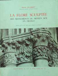
Jalabert, Denise
La Flore Sculptee des Monuments du Moyen Age en France
<p>Paris: A. et J. Picard et cie. Very Good; Covers lightly soiled and worn owner name on title page. 1965. Softcover. Light green illustrated softcover. Text in French. Many black and white photos and illustrations. Description of botanical ornamental sculpture on French medieval architecture. ; 4to 11" - 13" tall; 130 pages .</p> A. et J. Picard et cie paperback
Référence libraire : 62113
|
|
|
Jalabert, Pierre
LA PROVENCE ET LE COMPTÉ DE NICE
Paris: Fernand Lanore. Very Good-. 1938. Hardcover. Pages browned. Rebound in green cloth boards; B&W Photographs; 8vo; 238 pages . Fernand Lanore hardcover
Référence libraire : 18681
|
|
|
Jalas, Jaakko and Juha Suominen (Editors)
Atlas Florae Europaeae. Distribution of Vascular Plants in Europe. Volume 1: Pteridophyta (Psilotaceae to Azollaceae); Volume 2: Gymnospermae (Pinaceae to Ephedraceae); Volume 3: Salicaceae to Balanophoraceae; Volume 4: Polygonaceae; Volume 5: Chenopodiaceae to Basellaceae. Vol. 6: Caryophyllaceae (Alsinoideae and Paronychioideae); Volume 7: Caryophyllaceae (Silenoideae). Second Edition, 7 Volumes in III Volumes,
Cambridge University Press, Cambridge, New York a.o. 1988. 121 S. - 43 S. - 122 S. - 69 S. - 124 - 168 S. - 237 S. mit zahlreichen Abbildungen (Karten), with a lot of illustrations (maps), 4°, Original-Leinen mit Original-Schutzumschlägen, Ecken gering angestoßen, insgesamt gute und innen saubere Exemplare,
Référence libraire : 100159

|
|
|
 Recevoir par e-mail
 Télécharger en PDF
 Flux RSS


